
| |||||
| Wexford | Kilkenny | Waterford | Getting There | Tours | Gallery |
| Cork | Kerry | Clare | Tipperary | Galway | Mayo |
|
Places of Interest
Home Page
|
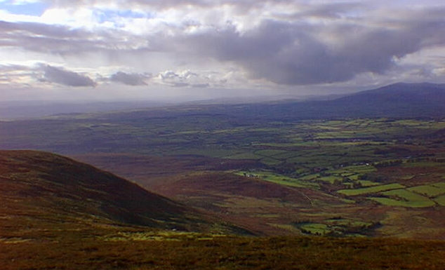
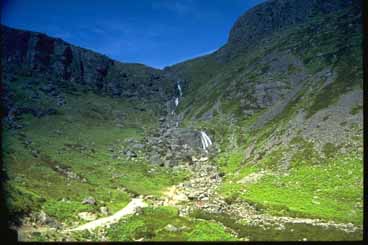 Mahon Falls
 Mahon Valley The Mahon Valley is the best know area of the Comeraghs. And in this area most people visit the Mahon Falls. There is a well maintained walking path that leads from a small layside car part to the falls itself. There are some good views here sweeping towards the town of Dungarvan and the Atlantic Ocean. My favourite time is late summer when the heathers are in bloom. Their colours dot the mountains in a blanket of pinks and purples. A circular route ascending the left hand side of the valley and crossing the top of the falls before heading up to Knockaunapeebra is an enjoyable walk. Descent can be made along the spur on the right hand side of the valley. On the way up to the Mahon Valley car park, as you pass through the gates, there is a stunted tree about 500 metres along the road on the left hand side. It is many a kid who demanded that their parents stop the car to wonder at what happens. If you stop and put your car into neutral it will roll magically back up the hill. This is a well known and unexplained phenomenon which really does work. Next door to Mahon Valley (Coum Mahon) is the Coum Tay valley which can be approached from the upper Mahon Falls car park. There are several small lakes at the top and if you walk the higher circuit you can see down into the Coumalocha in the Nire valley. There are also excellent views across to Coum Eag (the valley of death) and the Farbreaga (Fear Breige: false man) horseshoe.
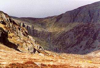
 Farbreaga Horseshoe Coumshingaun is the best example of a corrie lake in Europe. It's a spectacular coum which impresses you no matter how often you visit it. You can make a circuit of the lake from either the left or the right although it is harder to descend from the right hand side. While at the top, you can walk across to which at 792m is the highest point in the Comeraghs. There is a cairn at the top. For a good description of Coumshingaun read the 'Visitors Guide to the Comeragh Mountains' by Patrick Werner, published by the Blackstaff Press in 1978 and which can be viewed in the Waterford Room of the Waterford City library: "It is difficult to know how to write of Coumshingaun itself. Whether you speak of it as the geography textbooks do, as a magnificent example of corrie glaciation with the loch held up by a large black moraine or whether you see it as a guidebook says 'of unknown depth, associated with irresistable currents and evil spirits', in short whether you are practical or romantic, you are certain to be impressed". He adds: "It is about a mile long, roughly pear shaped, widest at it's western, precipitous end and except in winter when small streams flow down the precipices in headlong cascades, not visibly fed from any source . . . The water of the lake is constantly rippled by changing winds, sometimes steely blue in the sun, more often inky black, and always cold, though fish live in it. It is odd to speculate how they came there. I have seen it through a dazzle of sunshine, through swirling clouds of snow, through driving rain hissing off its surface and appearing and disappearing as mists eddied up and down the precipices and I have never failed to find it beautiful. Perhaps it is best to leave it at that". Near Coumshingaun is Crotty's Lake. William Crotty was a famous Waterford highwayman who was hung, drawn and quartered in the city in 1742. His hiding and look out place was a cave which overlooks the lake and after he was captured, his wife threw herself from Crotty's rock to her death on the cliffs below.
 The Corrie at Coumshingaun Coumshingaun Location: In the Comeragh Mountains. Perhaps one of the finest examples of a corrie or coum in Europe. Approached:From the Carrick-on-Suir to Dungarvan road. Park at Kilclooney bridge (GR. 348115), entering through a gate to the west, crossing a stream from which a vague path may be followed to the west. This track becomes more defined once you approach the mountain.
_____________________________________________________________________________________
Mahon Valley
______________________________________________________________________________________
Foill an Priosun
______________________________________________________________________________________
Fauscoum
 The Commeragh Mountains |
