
Performance Indicator 2.2:
"Describe volcano and earthquake patterns, the rock cycle, and weather climate changes."
The interior of earth has three parts: crust, mantle (upper and lower), and core (inner and outer). Scientists could not just take earth and get an x-ray to see inside. They sent vibrations into earth�s core and studied the changes in motion and speed as these vibrations moved into different mediums. By studying these earthquake waves a model was developed that showed Earth as having different layers. Continental crust and oceanic crust make up the thin layer on earth�s surface. The oceanic crust is dark colored and heavier than continental crust. Continental crust is made up of assorted rocks, which are 20 times older than the rocks of the ocean floor. The mantle consists of rocks heavier than that of the ocean crust. The rocks of the mantle can warp or change shape. Scientists� suspect the inner core is solid iron and nickel. Due to the extreme pressure from the above layers the iron and nickel do not have the ability to expand or melt. The outer core is made of molten iron. The movement of the molten iron is believed to cause earths� magnetic field. The movement of the liquid portion of earths� mantle may also be responsible for earthquakes, volcanic eruption and the formation of mountains and ocean basins.
Earthquakes are formed when sections of earth�s crust move past one another. Friction, the force opposing motion, prevents these plates from moving smoothly. The build up of friction causes stress, which releases as sudden jerking, or an earthquake. The crust is in the form of a plate, which is floating on molten mantle. Earthquakes release two types of waves: P waves and S waves. P waves are the primary waves that travel the fastest through the surface of earth. P waves are longitudinal while S waves are transverse. S waves are secondary waves which travel in a rolling fashion and are slower than P waves.
The theory of continental drift explains how the continents were once together. Through the years the continents slowly moved apart. If you look at the continents now it seems as if they are pieces of a jigsaw puzzle that can be put together. Fossils records have proven similar animals and plants in many different places. The plants and animals could not have traveled over such vast areas of ocean and survived unless the continents were joined at one point in time. The theory of sea floor spreading is more proof of the moving continents. The Mid-Atlantic Ridge has older rocks at the outer surface while the newer rocks are at the center of the ridge. This led to the theory of plate tectonics.
Plate tectonics combines the ides of sea floor spreading and continental drift. The continents are made of lighter rocks that ride high on the moving plates. The moving plates move in different directions and at different speeds. These plates may collide, move apart or slide past one another. Folded, tilted, faulted and displaced layers of rock also provide us with evidence of past crustal movements. Convection cells within the molten mantle could be the powerful force pushing these plates. These moving plates can form new mountains and volcanoes, which can result in causing earthquakes (earthquake information). Mount Everest is a great example of this theory. "Everest is moving at a speed of 1/16 inch to 1/4 inch each year because India, which sits on a shifting plate, is being shoved under a plate that supports Nepal and China." The entire mountain range is moving toward China.
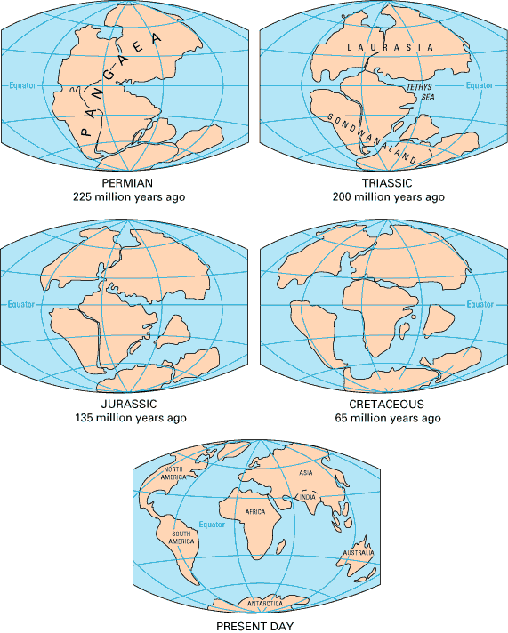
The theory of plate techonics begins with the supercontinent Pangaea. About 225-200 million years ago, this continent began to break up. The picture blow shows how todays continents came to be.
Rocks are the building blocks of Earth. There are three classes of rocks: Metamorphic, Igneous, and Sedimentary. Rocks are placed into categories based on how they were formed. The rock cycle explains how rocks were formed. Rocks may enter the cycle at any point and be fromed into any type of rock.

Weather is the temporary state of the atmosphere at a given time or place. Over a long period of time we can take an average of all weather conditions for a region. This average is referred ro as Climate. This characteristic weather pattern prevails season after season and year to year. The tilt of the earth causes uneven heating all around the world. The southern and northern hemisphere do not recieve the same amounts of sunlight during winter and summer. This uneven heating causes weather (temperature, precipitation, cloud cover, humidity and wind speed). The uneven heating of earth creates large moving air masses due to the density difference between warm and cold air. Warm air which is less dense is not affected by gravity as much as cold air which is more dense. The result of this is the creation of air currents, such as the Jet Stream and the Trade Winds. Warm winds carry more moisture than cold winds.
Some factors affecting temperature include latitude, altitude,large bodies of water and ocean currents. Latitude is what will place you in a certain climatic zone: polar, temperate or tropical. Your zone will determine your average temperatures.
Altitude is determined by how high above sea level a place is. As we have learned in the past, as we increase our altitude our air pressure decreases. As air pressure decreases the air becomes "thinner." This thin air does not conduct heat very well, so it is safe to say the higher the altitude the cooler the temperatures. If you are in Death Valley, California, you will be experiencing temperatures 114 degrees Fahrenheit. All you have to do is look to the adjacent mountains to see snow capped peaks. A short 1.5hour drive up into the mountains will revile the snow.
Water and land have different specific heats (they heat and cool at different rates). Large bodies of water can keep a place warm or keep a place cold. If you look at the picture below you will notice how New York is equal in latitude to Spain and Rome, Italy. New York has a climate which is colder than either of those two places, this is due to the Gulf Stream bringing cwarm water to Europeand the Labrador Current bringing the colder water down for the North East.

Some Hazzardous weather conditions have caused billions of dollars of damge not to mention deaths of many. These hazzardous conditions include hurricanes, thunderstorms, ice storms, tornadoes and blizzards.
