Return to Top
Washington State Park
Desoto, MO, MO 21 636-586-2995 HWY 21 to MO104
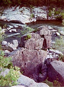
Washington State Park lies in a region of wooded hills, open glades and clear Ozark streams of 1,811 acres. You'll enjoy the park's natural communities, cultural features, recreation areas and hiking trails. The prehistoric "Mississippian" Indians used this area and left petroglyphs, rock carvings, remnants of their culture. Outdoor display area. Big River. Camp, canoe, hike. Nestled in the forest land of the east ozarks this park was once a ceremonial ground for prehistoric indians. Today the rock carvings are a special attraction.
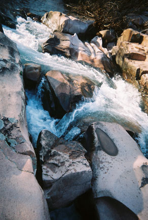
WSP represents the unique features of the eastern Ozarks as it contains a rich mixture of native forests. The Harwoods Natural Area and the Big River Flood Plain are most beautiful in the spring when the wildflowers, blue-eyed mary's, celandine poppies, bluebells, trilliums and violets are in bloom. The hills above the plains are limestone glades and savannas. These open forests and grasslands are throughout the natural area and trails. The rare species of flowering trees and unusual animal are found in WSP. The collard lizard is a favorite because it is reminiscent of a miniature dinosaur in its movement and appearance. The Big River borders the park , its dolomite bluffs offers a majestic view of the surrounding area and the river provides fishing, swimming and canoeing. There are trails and shaded campsites.
1,000 Steps Trail A 1.5 mile trail that follows the Big River floodplain up to the river bluff and back down. The bluff slope is rich wildflowers and ferns in the spring. This trail passes through the Washington Upland Hardwoods Natural Area. The name derived from the 1000 stone steps created during the 1930s, This trail is shared with the Rockywood Trail.
Oppossum Trail is a 3 mile loop that follows the ravine uphill parallel to the MO 104 Road. The trail skirts the campground and follows the scenic Big River bluffs and offers views of the valley. Also shared with the Rockywood Trail.
Rockywood Trail is a 10 mile trail with variations in its ruggedness, a clamber over glades, along high ridges and through wooded hollows. It travels through oak-hickory forests, rock outcroppings, high ridges, open cedar glades and valleys of prairie grasses and wildflowers.
Return to Top
Berryman National Recreation Trail
HWY 8 west to FS2266 or Hwy 44 to N to FS2265.
Berryman National Recreation Trail, Brazil Creek, Harmon Springs, Hazel Camgrounds suuround the 10 mile Ozark Trail- Courtois Creek section in a 25 mile loop.
Developed for horses. It can be hiked. It has many rugged segments leading from creek bottoms to ridge tops.
More for overnight camping with 4 camgrounds.
Return to Top
Bismark Lake
HWY U, Grider Rd., Lakeview Road.
Three trails are old forest roads and lakeside area, on 1,188 acres and the 210 acre Bismark Lake. Near Buford Mountain but not connected to the trail. The lake was formed by the headwaters of the St. Francois River. The lake is good sized for canoing and scenic viewing.
Return to Top


 The summit of Hughs Mountain is a climb of .5 mile. There is a beautiful view of the surrounding St. Francios Mountains and dup-close are unsual rock formations known locally as Devil�s Honeycomb. This formation is an example of igneous rock, rhyolite or volcanic rock that is the lava form of granite. These rhyolite columns are 3 to 4 feet high. The fractured rock is all round the igneuos rock glades that comprise half of the 330 acre natural area. The other half is forest land and includes Lost Creek and Cedar Creek.