

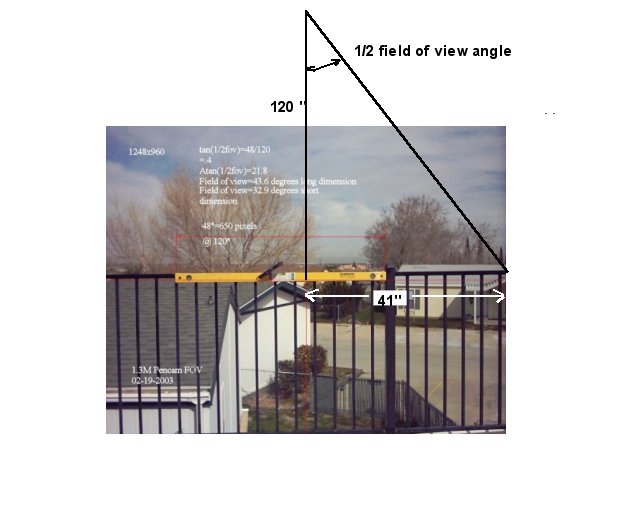
..A known quantity, in this case a 48 inch steel rule, placed orthogonally to
the plane of the imager, at a known distance, in this case 120 inches is used to find the
actual field of view (fov) of the lens being used.
The simplest photo to use is taken directly downward centered over the object
of interest... In this case the east end of the runway and pit area at the Antelope Valley Tailwinds..
The runway width is known to be 40 feet. This can be converted to pixels to deterimine the dimensions
of the area in the fov. And then using the 1/2angle equation above, the altitude of the plane at the
time the image was made is easily determined..
Image scale is determined by measuring the number of pixels of the steel rule, and proportioning
that to the overall image width.
Then using the 1/2 angle equation the field of view of the lens is found, in both directions..
This technique is used for the next aerial photo...


With this next, an oblique image, the altitude information is more difficult to extract, but it is there.

Again, knowing a dimension near the center of the image permits scaling the image. The backyards are
said to be 75 feet wide. By looking at 7 of them the dimension used is 525 feet. Which for this picture
turns out to be almost half the image width in pixels. Using the 1/2 angle equation it is now possible
to determine the distance the airplane is from the center of the image.. note this is not altitude.
To find the altitude, extending the property lines up to near the edge of the image, the pixels representing
the 525' dimension can be determined, and these propotioned to the already computed distance.
And as it happens this new measurement line is close to the edge of the fov, it is possible to presume
the angle between the two distances. With 2 sides and an angle, the resultant triangle can be determined
using the "Law of Cosines" (106.2 degrees). The interior angle found is then subtracted from 180 to get its complement (73.8 degrees).
And now knowing two angles and a side (the first distance) the altitude pops out with the sine function. It is also possible to
determine the aircraft pitch angle, as the camera is mounted looking straight down. The pitch angle will be
the interior angle previously determined, rotated 90 degrees. Further, the position of the camera
relative to the image can be found by relating the field of view to the altitude and distance using
the complementary angle. (73.8+16=89.8, or right at vertical. The airplane is over the street
at the bottom of the image)
..photo by
Dreamer

..Getting complicated ...

..Oblique photos can be the most difficult... This one by Neil Morse lended itself to analysis using AutoCAD and searching the Internet for information on the physical structure of the Oakland Bay Bridge. Drawing up a full-scale image of the bridge in AutoCAD, and then overlaying that on the image, moving the observer's lccation until a match between the image and the drawing occured resulted in the information seen in the combined image/drawing
...Flight Test aerial photography..
..A compendium of Aerial Photography information..
..Aerial photos of construction..
..Wandering Escapees in the Antelope Valley.
..Calibrating and reading aerial photos.
