|
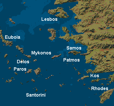
When people think of the Greek islands, they generally think of the Aegean islands, ignoring the equally attractive Ionian and Argosaronic islands. The Aegean islands, as the name implies, are the islands that lay east of Greek between Turkey and Greece in the Aegean Sea. As I discovered first hand, the Aegean Sea is huge, with a 12-hour boat ride from Athens to Lesbos and a 16-hour boat ride from Rhodes to Athens (though it stopped a lot). Because of this size the islands vary greatly because of their geography and history and thus are grouped into four groups.The Cyclades are the Greek poster children. The Cyclades are the stereotypical white washed islands with box like houses and very colorful domes. They get their name because they form a circle around the island of Delos. Delos was the birthplace of Apollo and Artimis and thus was a very important cultural and spiritual center in antiquity. Because of this the Cyclades were held in reverence. In the time of the Roman, Byzantine and Ottoman empires they were neglected. As a result the inhabitants needed to protect themselves from pirates so built maze like towns out and white washed their houses to blind and confuse invading pirates (so they could run for cover). As a result they were being neglected they were able to hold on too much of their Greek culture and are quite picturesque, even if overrun by tourists in the summer. The Dodecanese are located in the southeastern Aegean and get their name from the fact that there are twelve islands in this group. Because of their location, close to the Turkish coast and of strategic importance for the constant armies moving east (Roman, Greek, Venetian, French) and West (Persian, Ottoman) they contain a pleasant mixture of eastern and western architecture coexisting in harmony. They have wonderfully preserved/rebuilt ruins and are a joy to visit. The North Eastern Aegean are aptly named for their location. They are spread out considerably north to south and as a result share a varied histories and architectures. The Rough Guide (2001) describes this as an arbitrary arpeggio because of being spaced out and because each island has its own unique features, heritage. Visiting three of these islands and getting a good look at a fourth the only common feature I could see is that they had no common features. The last Aegean group is the Sporades, which make up the North Western part of the sea. They are very close to the mainland, mostly being sunken mountaintops left over from the land bridge that connected Turkey and Greece in the last ice age. As a result of their location, they are frequent holyday islands for Greeks and tourists alike. | ||||||||||||||||||||||||||||