Cuivre State Park
Lincoln County. Troy. MO HWY 47. 636-528-7247.
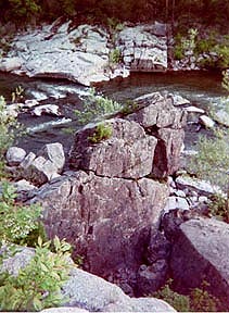
Scenic limestone bluffs offer overlooks of the Cuivre River in this park of 6,393 acres. Big Sugar Creek, an undisturbed stream of the northeast area and home to several fish species, flows through the park. Hardwood dense forests of white oak, sugar maple and northern red oak are in this southern ozark like wilderness. The bottomlands are filled with sycamore, bur oak, black walnut and hackberry tree. In addition you may see tall grass native prairies, woodland flowers, sinkhole ponds, rock-bottomed streams, springs, rocky glades (growing Missouri coneflower) and savannas that are being preserved and restored. Over 30 miles of hiking, backpacking, horseback riding trails traverse though the Lincoln Hills Natural Area, 1,872 acres. Features of this park are: Lake Lincoln (stocked lake of 55 acres), Sugar Creek and Big Sugar Creek Wild Area, Camp Sherwood Forest, Sac Prairie, Northwoods Prairie and Northwoods Wild Area. The Wild Areas are home to a variety of bird species that need large forests as their habitat, such as the pileated woodpecker and broad-winged hawk. Outdoor activities include hiking, swimming, boating, fishing, picnic sites, and camping in primitive and modern sites. The visitor center illustrates the cultural and natural history of the park.
10 TRAILS:
Blazing Star (2 miles) and Prairie Trails (.2 miles) that offer exploration of the native grasslands and savannas.
Lone Spring (6 miles) and Big Sugar Creek Trails (7 miles) traverse the wild area and welcome backpack camping.
Cuivre River Trail (7 miles) has an equestrian campground.
Hamilton Hollow Trail (1 mile) has a wide array of wildflowers and large trees, Turkey Hollow Trail (1 mile) crosses a field to upland forest through a valley to the ridge to overlook tower, and Mossy Hill Trail (1 mile) follows a wooded valley, crosses Mossy Hill to an open forest of luxurious growth.
Frenchman's Bluff Trail (2 miles) follows Goedde Creek, winds up a hill to the top of the 120 ft. limestone bluff, which offers spectacular views of the Cuivre River Valley.
Lakeside Trail (4 miles) follows along the shoreline of Lake Lincoln, where the wildflowers are in abundance in summer.
WILDERNESS AREAS:
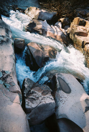
Northwoods Wild Area these lands surrounding Big Sugar Creek retain wilderness qualities rare in northern Missouri. Big Sugar Creek has characteristics similar to the streams of the Ozarks. It bisects the 1,102 acre wild area and has cut into the limestone plateau. Along the creek there are several small bluffs and streams. The forest on the hills are create a White-Oak tree canopy. Found in this area is a large variety of wildlife.
Big Sugar Creek Wild Area is 1,675 acres of lush floodplain terrain and features sculpted landscape where the creek has carved through the limestone to form its rugged forested watershed. Bluffs along the creek are very rugged. Limestone glades and their unique flora are found along the bluff tops and hillsides.
Return to Top
Graham Cave State Park
Montgmery County.
Recreational and Educational opportunities in the hills above the Loutre River. Graham Cave is a combination of dolomite and sandstone, gradually waters flowing through the sandstone, and by wind and freeze actions the large cave
was created. The entrance to the cave is arched 16 feet high
and 120 ft. wide. Artifacts were uncovered which provide information of the lifestyle of the ancient Dalton and Archaic period Native Americans, who were primarily hunters that first inhabited the cave.
Busch Wildlife Conservation Area
2360 HWY D. St. Charles. 314-441-4554.
17,500 acres. (Comprised of three Conservation Areas.) Grassland, cropland and forests. There are 32 fishing lakes from 1 acre to 182 acres in size.
Trails:
Pine Trail is .2 miles consists of a pine plantation. Dardene Creek Trail is .4 mile loop that features a stream and it wildlife. Woodland Trail is .2 mile loop, a forested woodland area. Wildlife Management Trail is .4 mile loop., this trail includes various habitat and wildlife, ponds, brush piles and forests. The Prairie Trail a .2 mile loop, offers native grasses and prairie forbs. Fallen Oak Nature Trail is a .7 mile loop, and is an asphalt trail highlighting a variety of habitats, bird feeding station and tree identification. Busch Hiking/Biking Trail is 3.2 miles it travels over a dam on Lake 19, and through fields.
Nearby Conservation areas are Maria Temps Clair, Weldon Spring and Howell Island.
Katy Trail State Park
HWY 70. St. Charles. Fifth Street Exit. Machen, mile post #27. St. Charles. 314-751-2479 or 1-800-334-6946.
The Katy Trail's 225 miles follows the Missouri River.
The Katy Trail State Park is designed for hikers and bikers.
This recreational trail of 200 miles extends from Machen, St. Charles County to Sedalia in Pettis County. The trail is developed in stages and sections. The eastern section is 38 miles and from St. Charles to Marthasville. The western section is 35 miles from Rocheport to Jefferson City. The Katy Trail meanders through a wide variety of Missouri's scenic lands
capes, limestone bluffs, wetlands, deep forests, open pastures
and historic river sites. Wildlife is abundant along the trail.
St. Charles to Marthasville
This portion of the trail is from Frontier Park in St. Charles to the trail head in Marthasville, this section is 38.2 miles.
In this section there is a variety of natural attractions, linestone bluffs border the trails through Weldon Spring Wildlife Area, more bluffs appear consisting of dolomite and sandstone. Thge Klondike Quarry area expose a fine sandstone area. A white quartz sandstone. The biological diveristy consists of wetlands and forests. Wildflowers are abundant and the trail is ideal for photography or birdwatching, because of its location along the Missouri River. The towns along the trail reflect the rich history of the region, St. Charles, Defiance, Matson, Augusta and Marthasville.
Return to Top
Lewis & Clark Intrepretive Center
701 Riverside. 636-947-3199.
The Center interprets the expedition through exhibits, literature and educational programs. $1 adults.
Point Confluence State Park, Missouri & Mississippi Rivers
St. Charles
New State Park development of 202 acres. Restoration of the area to its native wetlands and forests, characteristic of the Lewis and Clark travels. Open in 2004.
Return to Top