|
St. Francois
Mountains
Natural Area
St. Francois
State Park
2,375 acres
4 Trails:
11 miles (two loops a 6.7 and 4.3 mi.), 2.7 miles and .5 mile
8920 US Highway 67 North
Bonne Terre, MO 63628
Contact:
573-358-2173
St. Joe State Park
8,238 acres
Trails: 13.8 Miles, 1.5 mile
Hiking, Bike, Equestrian, and Paved
Hwy 67 to 32
Contact:
Park Hills, MO
573-431-1069
|
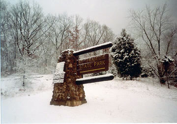
  St. Francois State Park
HWY 67 North. Bonne Terre, MO. 573-358-2173
St. Francois State Park offer visitors a chance for solitude in a 2,735 acre wilderness setting of rare plants and wild animals.
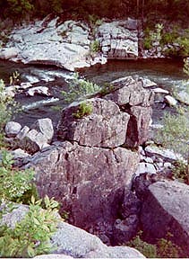
It is a natural refuge from everday life in this peaceful, natural setting of Pike Run Hills, southern boundary of the Big River and Coonville Creek of St. Francois County. The park is rich in natural history and cultural history.
Trails:
Pike Run Trail, Mooners Hollow, Swimming Deer, and Missouri Trail.
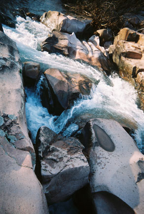
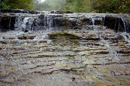
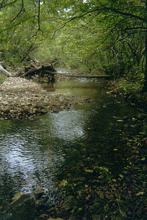
Hiking trails through the forested hills, dolomite bluffs and grassy opening glades. Along Coonville Creek Natural Area and the Big River.
Pike Run Trail (11 mi) 6.7 mi. The rugged ridge and ravine are divided into the Southern loop and 4.3 northern loop. (Elev 700-900ft) Backpack and equestrian use. It was an old logging trail so expect rough eroding ascents and descents.Expect limestone glade overlooks and small creeks and mini waterfalls, esp in spring. Mooners Hollow Trail (2.7 mi.) loop. follows the narrow steep valley of Coonville Creek. (Elev 700-800 ft.) Allow 2 hours for the hike. Trail markers are along the stream and ridge slopes. The 3-mile spring fed cool cascading waters of the Ozark stream once supplied moonshiners with this valued ingredient where they had several stills. Hiking trails located in the camping site are: Swimming Deer Trail (2.7 mi) Allow 2 hours for this trail. Forested plains and for 1 mile along the bluffs of the Big River. Missouri Trail (.5 mi.) skirts the campground,it contains a wide range of vegetation.
 Trees: White Oak, Black Oak, shagbark Hickory and Dogwood, sycamore, ash, Ohio Buckeye, silver maple, and black walnut
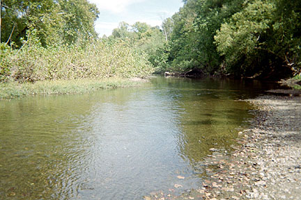
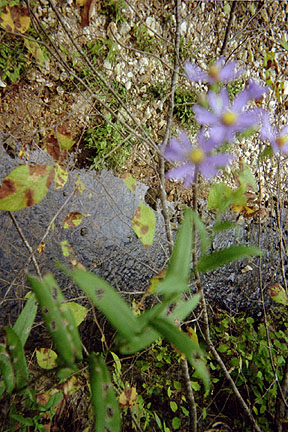
Plants: Wildflowers, such as Queen of the Prarie, mountain mint, bog Coneflower, celandine poppy, and wet meadow ferns Rock: Dolomite Bluffs Waterways: Coonville Creek-Small springs, tributaries and wet meadows feed the Ozark stream. Big River-Southern boundary ideal for wading, fishing, novice canoeing b/c shallow waters, and a few swimming holes. Animals/Fish: bass, catfish, sunfish, darter Birds: Warblers, tanagers, thrushes and flycatchers Other Activities: Picnic, campground (electronic) sites, Playground area, ball fields and shelters,
equestrian trails.
Trees: White Oak, Black Oak, shagbark Hickory and Dogwood, sycamore, ash, Ohio Buckeye, silver maple, and black walnut
Plants: Wildflowers, such as Queen of the Prarie, mountain mint, bog Coneflower, celandine poppy, and wet meadow ferns Rock: Dolomite Bluffs Waterways: Coonville Creek-Small springs, tributaries and wet meadows feed the Ozark stream. Big River-Southern boundary ideal for wading, fishing, novice canoeing b/c shallow waters, and a few swimming holes. Animals/Fish: bass, catfish, sunfish, darter Birds: Warblers, tanagers, thrushes and flycatchers Other Activities: Picnic, campground (electronic) sites, Playground area, ball fields and shelters,
equestrian trails.
Return to Top
St. Joe State Park
Hwy 67 to 32 West. State Route B, Primville Rd., Park Hills, MO 63601, 573-431-1069.
This state park is 8,238 acres. Third largest state park. Lakes and beaches.Trails:Harris Branch, Blankshire, Primvile,
Red Trail and Lakeview Trail. There are 13.8 miles of paved bicycle trails and 15 miles of wooded trails. The terrain ranges from level to fairly steep hills along some portions of the trail. Primville hiking/biking trail is connected by a .6 mile spur where the south section is 3 miles and the north section is 8 miles in length. The park contains forest growth, four lakes, including Monsanto Lake. Recreational activities are camping, swimming, boating and fishing, trails for hiking, excellent for biking and equestrian riding and portions are handicap accessible. Off road vehicles (ORV) are popular in St. Joe Park, in 2,000 acres of riding area. Nearby there are historic buildings. Lakeview Trail 1.5-mile loop. It is partially paved (.2 mile), which is ADA accessible. Red Trail 7.5-mile loop at Primville Road.
Return to Top
Knob Lick Mountain Lookout Tower
HWY 67 to Canterberry Road.
Knob Lick Mountain 89 Acres site is on the eastern edge of the St. Francois Mountains. From this Elev. 1,333 ft. there is a beautiful expansive view of the region. The trail consists of short paths , one along the glade area of the mountain crest and the other down to the base of the mountain. The 1 mile trail passes through five acres of boulders and wild flowers. The 400 ft wide open space offers a spectacular view of the St. Francois River Valley. The base of the mountain trail begins at the grassy side of the forested edge. This is an wide open path that travels downhill .25 mile.
Missouri Mountain Peaks & Summits, 88
Nearby, Castle Rock in Madison County, a mountain pillar.
In St. Francois Mountains and summits
KnobLick,
CastleRock,
Taum Sauk Mountain,
Wildcat Mountain,
Buford Mountain,
Lead Hill,
Russell Mountain,
Proffit Mountain
Bell Mountain, &
Ketcherside Mountain.
Iron Mountain Lake
Iron Mountain Lake is 100 acres. Fishing Bass
Catfish and Sunfish.
Return to Top
Azelea Wildflower Area
From JCT 00, to MO 72 or HWY 67 (roadside preserve area). Spiva Azelea & Silas Dees.
The preserve is 5 acres of wilderness area and user paths, and owned by the Nature Conservancy, yet the wildflowers may be seen along the back roads of the St. Francois Mountains. April to May are the best months to visit this small haven of colorful spring wildflowers on the level bottom and hillside. The azalea cover the rocky, open wooded hillside. Azalea, called rose azalea or wild honeysuckle, is a small perennial shrub. Many other spring flowers are in bloom in this preserve, flowering dogwood, paw paw, bedstraw, goats rue, several ferns, wild ginger, cohosh and blueberry bush.
|