Mastadon State Park & Historic Site
425 acres
3 Trails: 2.25 miles, .75 mile and .5 mile
Route 66 State Park
420 acres
Trails:
4 multi purpose trails
Valley View Glades Natural Area
225 acres
Victoria Glades Natural Area
101 acres
Washington State Park
1,811 acres
3 Trails: 1.5 mile, 3 miles and 10 miles
Pacific Palisades
692 acres
LaBarque Creek Conservation Area
1,274 acres
Don Robinson State Park
843 acres
|
Mastadon State Park & Historic Site
HWY 55. Imperial. 1050 Museum Drive. 636-464-2976.
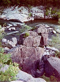
This site contains important archaelogical sites in Missouri. Excavation of American Mastadon remains and Indian artifacts of the Clovis culture, reveal they were of the Pleistocene ice age. A study site of ice age man and animals in North America up to 10,000-14,000 years ago. The Museum displays ancient specimens for a fee.
These 425 acres are open for day use for picnics and hiking. There are 3 trails: Limestone Hill (2.25 miles), steep and rugged on limestone bluffs; Spring Ranch (.75 mile) Rock Creek bottomland Bollefer Spring Stream; and the Wildflower Trail (.5 mile) passes the Callison Memorial Bird Sanctuary to the Bone Bed.
Visit Kimmswick.
Blue Owl
Route 66 State Park, St. Louis County
Note: With the closing of the Old Route 66 Bridge, there are now two different ways to access facilities at Route 66 State Park. St. Louis County.
Directions
I-44. Visitor center: Exit 266/Lewis Road; Exit 264/Hwy. 109; near Tyson County Park.
Route 66 State Park: Exit 265/Williams Rd.
Contact: (636) 938-7198. 97 North Outer Road, Suite 1, Eureka, MO 63025-1628.
This 480 acre park is located along the bluffs and woods of the Meramec River Valley. There are wide open trails to the rivers view and edge of Meramec River. There are more than seven miles of trails for hikers and family walkers, bicyclists, and bird watchers. In Spring and certain areas there are many deer roaming the park. A portion of the original Route 66, including a historic bridge across the Meramec River, runs through Route 66 State Park. A roadhouse along Route 66, built in 1935, is the park's visitor center. Route 66 - The Mother Road, quoted by John Steinbeck, author. The area was the former Times Beach Community.
Return to Top
Valley View Glades Natural Area
Highway 21 and Highway B for 4.5 miles. Hillsboro. Contact: MDC, St. Louis Regional Office, 636-441-4554; 636-458-2236
This 225 acre natural area contains Cedar Hill and Belew Creek; the area is part of a large complex of glades starting just east of the Big River, near Morse Mill and extending eastward and beyond Hillsboro and Desoto. It features large scenic glades that have diverse flora and animal life, over 250 species. The 2.5 miles Valley View Glades Trail is a loop through the glades and woodlands. The dolomite bluffs border the scenic glades. The area also features Oak Hickory forests and small creeks in the Mississippi River section of the Ozark Border Natural Division. The Natural Divisions of Missouri
Plants: Leather Flower, Missouri Evening Primrose; Little bluestem and sideoats grama grasses.
Victoria Glades
HWY BB, west of Hillsboro
101 acres of the Nature Conservancy Organization.
Plants: Leather Flower, Missouri Evening Primrose; Little bluestem and sideoats grama grasses.
Washington State Park
Desoto, HWY 21 to 104. 636-586-2995.
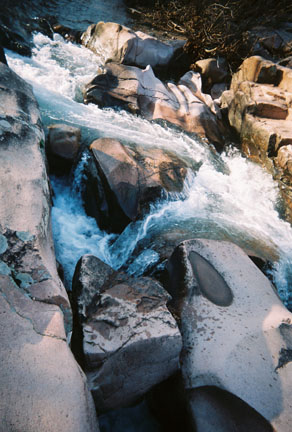
Washington State Park lies in a region of wooded hills, open glades and clear Ozark streams of 1,811 acres. You'll enjoy the park's natural communities, cultural features, recreation areas and hiking trails. The prehistoric "Mississippian" Indians used this area and left petroglyphs, rock carvings, remnants of their culture. Outdoor display area. Big River. Camp, canoe, hike. Nestled in the forest land of the east ozarks this park was once a ceremonial ground for prehistoric indians. Today the rock carvings are a special attraction. Washington State Park represents the unique features of the eastern Ozarks as it contains a rich mixture of native forests. The Harwoods Natural Area and the Big River Flood Plain are most beautiful in the spring when the wildflowers, blue-eyed mary's, celandine poppies, bluebells, trilliums and violets are in bloom. The hills above the plains are limestone glades and savannas. These open forests and grasslands are throughout the natural area and trails. The rare species of flowering trees and unusual animal are found in the park. The collard lizard is a favorite because it is reminiscent of a miniature dinosaur in its movement and appearance.
The Big River borders the park , its dolomite bluffs offers a majestic view of the surrounding area and the river provides fishing, swimming and canoeing. There are trails and shaded campsites. 1,000 Steps Trail A 1.5 mile trail that follows the Big River floodplain up to the river bluff and back down. The bluff slope is rich wildflowers and ferns in the spring. This trail passes through the Washington Upland Hardwoods Natural Area. The name derived from the 1000 stone steps created during the 1930s, This trail is shared with the Rockywood Trail. Oppossum Trail is a 3 mile loop that follows the ravine uphill parallel to the MO 104 Road. The trail skirts the campground and follows the scenic Big River bluffs and offers views of the valley. Also shared with the Rockywood Trail. Rockywood Trail is a 10 mile trail with variations in its ruggedness, a clamber over glades, along high ridges and through wooded hollows. It travels through oak-hickory forests, rock outcroppings, high ridges, open cedar glades and valleys of prairie grasses and wildflowers.
Return to Top
Pacific Palisades Conservation Area
1.5 miles south of Pacific on Route F, then 1/10-mile east on English Road.
Pacific Palisades Conservation Area is a 692-acres. This area contains forest, cropland, and fields, a stream (Meramec River) and sand and gravel pits which provide seasonal fishing and birdwatching.
LaBarque Creek Conservation Area
1,274 acres in northwestern Jefferson County, Missouri. It is south of Pacific and southwest of Eureka. The LCCA is part of the Henry Shaw Ozark Corridor.
Don Robinson State Park
843 Acres
|