
This report is an addendum to the Paleontological Locality Data Report that was filed at the Prehistoric Museum of the College of Eastern Utah in November 1999.
This interim report presents the results of investigations carried out from June to November, 1999. The investigation is not complete. All observations and conclusions are tentative. They may be altered or corrected as a result of further work.
Readers are advised that the authors of this report are NOT professional geologists or paleontologists and all observations and conclusions should be evaluated accordingly.
The area described in this report is administered by the US Bureau of Land Management and is subject to all its applicable laws and regulations. In particular, collection of many of the concretions may be subject to the laws regulating the collection of petrified wood.
A HTML version of this report is available
online at:
www.angelfire.com\ut\pegnbob\InterimRpt.htm
Copies of this report in HTML and Microsoft Word© format
are available on CD-ROM by request to the authors.
Table of Contents
(Click on desired
Title to go directly to Item - Click on browser "Back"
button to return to this page.)
TITLE
#Purpose
#Disclaimer
#Caution
#Distribution
Table of Contents(This page)
#List
of Illustrations
#Acknowledgements
#INTRODUCTION
#Location
#Previous Work
#DESCRIPTION
OF CONCRETIONS
#Concretions
from the Ferron Sandstone
#Concretions
and Fossil Wood From the Tununk Shale
#Indented
Concretions
#Diagenetic
Orientation of Indentations
#Unindented
Concretions
#Woody Concretions
#Petrified
wood not in concretions
#Flattened
Concretions
#STRATIGRAPHY
#Basis of Identification
#Correlations
to previously named strata
#DISCUSSION
#PLANS
FOR THE YEAR 2000 FIELD SEASON
#References:
LIST
OF ILLUSTRATIONS
(Click on Figure
Number to go directly to Illustration - Click on browser "Back"
button to return to this page.)
#Figure 1. A typical large Ferron concretion in situ.
#Figure 2. Partially disintegrated large
Ferron concretion lying on weathered Tununk shale surface.
#Figure 3. Partially disintegrated large
Ferron concretion with shelly concretion still in center.
#Figure 4. The interior of a shelly Ferron
concretion prepared for display.
#Figure 5. The weathered interior of a
shelly Ferron concretion.
#Figure 6. Top (3/4) and profile views
of a typical concretion with a single indentation.
#Figure 7. Photos of two typical indentations.
#Figure 8. Six single-indentation concretions
found on surface.
#Figure 9. Two concretions with two indentations
each.
#Figure 10. A concretion with three indentations.
#Figure 11. Three views of a concretion
with two indentations.
#Figure 12. Side and 3/4 end views of
an elongated concretion.
#Figure 13. A concretion with two large
indentations.
#Figure 14. Concretion of Figure 13 opened
around cut through axis of indentation.
#Figure 15. Concretion of Figures 13
&14 opened.
#Figure 16. An indented concretion cut
through axis of indentation.
#Figure 17. Close-up view of indented
area of Figure 16.
#Figure 18. An indented concretion in
situ in bedrock.
#Figure 19. Cross section view of unindented
concretion.
#Figure 20. Woody concretion that was
split by weathering.
#Figure 21. Typical woody concretion
disintegrated by weathering.
#Figure 22. Petrified wood from disintegrated
concretion with animal boreholes.
#Figure 23. Woody concretion with wood
partially exposed by weathering.
#Figure 24. Probable woody concretion
with elongated indentations.
#Figure 25. Side and cross-section views
of typical petrified wood.
#Figure 26. Side and cross-section views
of flattened concretion.
#Figure 27. Overview of northern one-third
of study area.
#Figure 28. Closer view of northwest
end of study area.
#Figure 29. Two views of the sandstone
layer that caps hills containing concretions. (Northwest end.)
#Figure 30. Two views of sandstone layer
that caps hills containing concretions.(Center)
#Figure 31. Aerial photo of area producing
unusual concretions.
#Figure 32. Geologic Map of area where
unusual concretions originate.
We would like to thank the following people for their interest and participation in this project:
Don Burge, Director of the College of Eastern Utah Prehistoric Museum. Don was always ready with help and encouragement, and we found, in a book he recommended and loaned to us, the first hints of a solution for the puzzling phenomena we were finding.
Dr. R. V. Dietrich, Professor Emeritus of the University of Central Michigan. We have met him only via the Internet, but Dr. Dietrich answered our first tentative Email with kind interest, and since that time has given generously of his time, knowledge and advice. His appropriate questions have kept us on course, and the fact that a scientist of his accomplishments was interested in our investigations inspired us to continue.
Mrs. Rose Difley, Graduate Student in Paleontology at the University of Utah. Rose was the first trained scientist to show interest in our project and her ability and willingness to procure technical papers and to share the benefits of her contacts at the "U" has made the continuation of this project possible. And also to Rose's husband, John, who took time from a Sunday afternoon to subject one of the concretions to his mason's saw, thus giving us our first look at the inside of the mystery.
Dennis Geary, Master of the Rock Saw and strong companion on long hikes. Dennis never refused our requests for "just one more saw cut", and he always remained cheery while lugging a heavy pack of rocks across the desert. And to Dennis' wife, Theresa, for her cheerful companionship on desert trips, and for not objecting when Dennis spent his evenings sawing rocks for us.
Dr. Steven Manchester, Assistant Curator of the Florida Museum of Natural History. His generous interest and encouragement helped greatly in the preparation of this report. His identification of the taxonomy of the first thin sections prepared from the concretions preserved the momentum of this investigation and gave additional reasons for continuing it.
Dr. Elisabeth Wheeler, Professor at the State University of North Carolina. Dr. Wheeler's interest and encouragement have been an inspiration. She is continuing her support as this report is being prepared.
The study area is located along the northeastern flank of the San Rafael Swell in Emery County, Utah. The exact location is recorded in a Paleontological Locality Data Report filed in the Prehistoric Museum of the College of Eastern Utah in Price, Utah.
Molenaar & Cobban (1991) measured and described the overall stratigraphy of an area which includes the area of this report.
Witkind (1980) mapped the surface geology of the area described in this report.
Riemersma (1989) described the stratigraphy of Ferron Sandstone and Tununk Shale members of the Mancos Shale in the area described by this report.
Balsley (1969) studied the concretions found in the Ferron Sandstone that directly overlies the study site. He was the first worker to propose the "excrementation" theory for the origin of the masses of mollusc shells found in some of the concretions. The area of origin of the concretions that are the subject of this report is immediately adjacent to and stratigraphically below the area covered by Balsley. Many weathered remnants of the concretions Balsley described have moved down-slope onto the study site.
The authors are unaware of any previous studies of the unusual concretions that are the subject of this report.
Concretions from the Ferron Sandstone
These concretions are described here only because their weathered remnants are distributed over the area where the concretions that are the main subject of this report are found.
Balsley (1969) described these concretions as follows:
"Two distinct types of concretions occur in the zone: large (1 to 6 feet in diameter), spherical to elliptical, slightly fossiliferous, to unfossiliferous concretions {figure omitted}, and small (3 to 14 inches in diameter) ovoid, highly fossiliferous concretions {figure omitted}. The spherical concretions are about one-fifth as numerous as the ovoid ones. Several examples {figure omitted} were found in which ovoid concretions were found included in the spherical ones. This evidence … shows that the spherical concretions were formed after the ovoid ones."
For this report we will refer to the above large spherical concretions as "large Ferron concretions" and the small concretions as "shelly Ferron concretions".
Figures 1 to 5 show typical examples of the Ferron concretions.

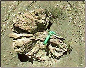
Figure 1. A typical large Ferron concretion in situ. The rock hammer is 33cm long
 |
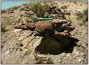 |
| Figure 2. A disintegrated large Ferron concretion lying in the Tununk Shale surface. | Figure 3. A disintegrated large Ferron concretion with shelly concretion still in place in center. |
 |
 |
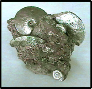
| Figure 4. The interior of a shelly concretion prepared for display. | Figure 5. The weathered interior of a shelly concretion lying on the Tununk Shale. |
Numerous weathered concretions of the types pictured above are scattered over the area of origination of the concretions that are the focus of this report.
Concretions and Fossil Wood from the Tununk Shale
This report describes only the concretions and fossil wood that are found in a specific area of restricted size as defined later in this report. There is no intent or claim to coverage of all of the Tununk Shale. All specimens found to date were at least partially exposed on the surface.
Indented Concretions. These concretions are characterized by one or more indentations in the periphery. They are the most numerous of any type found in the study area. They are round to ovoid to cardioid, usually quite regular but occasionally irregular in profile. They are round to slightly flattened in cross section. They measure 10 cm to 30 cm on their largest dimension.
The indentations are round to somewhat flattened and resemble the attachment point of the stem of an apple or melon. They are 1.5 cm to 5 cm deep. Concretions with a single indentation are most common, but a few with two, three, or more indentations have been found.
Although only a partial census has been made, we estimate that there are 100 to 200 indented concretions exposed in the study area. We searched several areas with apparently identical stratigraphy within a few miles of the study area - no indented concretions were found. We have not found any descriptions of similar concretions in a search of the literature and Internet sources.
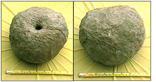
Figure 6. Top (3/4) and profile views
of a typical concretion with a single
indentation. Largest dimension is about 20 cm.
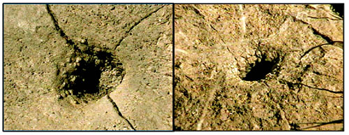
Figure 7. Photos of two typical indentations. Note cracks radiating from indentations. Most specimens have these cracks.
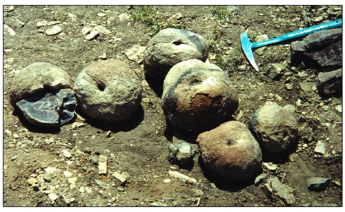
Figure 8. Six single-indentation concretions found on surface in an area about 10 meters in diameter and collected in one area for photo. Concretion on left is shown as found, i.e.; opened by weathering. Note crack running through indentation on uppermost concretion. Most indented concretions show similar cracks which appear to be caused by weathering associated with the indentations. Rock hammer is 27 cm long.
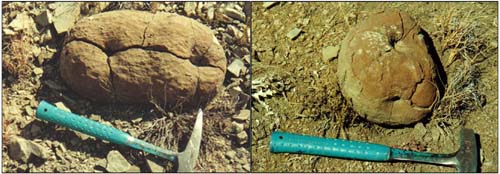 Figure 9. Two concretions
with two indentations each. Note that concretion on left has indentations
with axes nearly parallel - concretion on right has indentations
with axes perpendicular.
Figure 9. Two concretions
with two indentations each. Note that concretion on left has indentations
with axes nearly parallel - concretion on right has indentations
with axes perpendicular.

Figure 10. A concretion with three indentations - axes of all three are parallel. White on surface is similar to caliche - probably a recent deposit.

Figure 11. Three views of a concretion with two indentations - one indentation in each end. Axes of both indentations are roughly parallel to each other and to the long axis of the concretion.
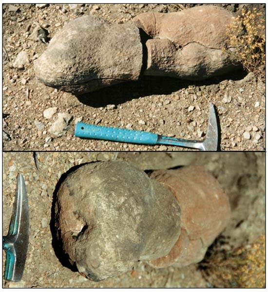
Figure 12. Side and 3/4 end views of an elongated concretion with two large indentations - one near center and one at left end - and two smaller indentations. Concretion was found broken with two parts separated by 2 or 3 meters. Parts were placed in approximate pre-weathered relation for photos.
The components of indented concretions are complex, and can be
described as follows:
* A thin (<0.5cm)outer cover of tan/gray/brown sandstone.
* A body of dense, dark gray to black rock, presumed to be carbonate.
The carbonate occupies all of the interior space of the concretion
not occupied by the components described below.
* Veins of crystal resembling septarian nodules. The thickest
crystal veins are 5cm wide. They are thicker in the center of
the concretions and thinner, tapering to a point, as the veins
near the outer edge of the rind. All crystal veins appear to be
connected. The crystals vary from white, through brown, to dark
gray/near black in color. The crystals dimensions range from 1cm
to microscopic. The veins reach the exterior of the concretion
only at the deepest points of the indentations.
* Black inclusions in the crystal veins. These inclusions are
larger and blacker than the largest, darkest crystals.
* One concretion (see Figures 15 & 16) has an unusual inclusion
with cell structure easily visible to the naked eye.
* No indented concretion has been found to contain voids.
* No indented concretion has been found to contain shells.
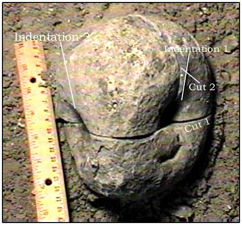
Figure 13. A concretion with two large indentations. Saw cuts have been made through the axes of both indentations. A possible small third indentation is visible below indentation 1.
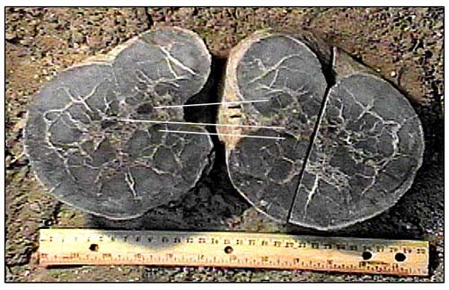
Figure 14. Concretion of Figure 13 opened around cut through axis of indentation 2. White lines connect sides of black inclusions that were divided by cut.

Figure 15. Concretion of Figures 13 & 14 opened around cut through axis of indentation 1. White line connects parts of black inclusion that were separated in cutting process.
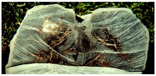
Figure 16. An indented concretion cut through axis of indentation,
revealing inclusion with cellular structure (See Figure 17) at
indentation. Concretion is 20cm diameter.
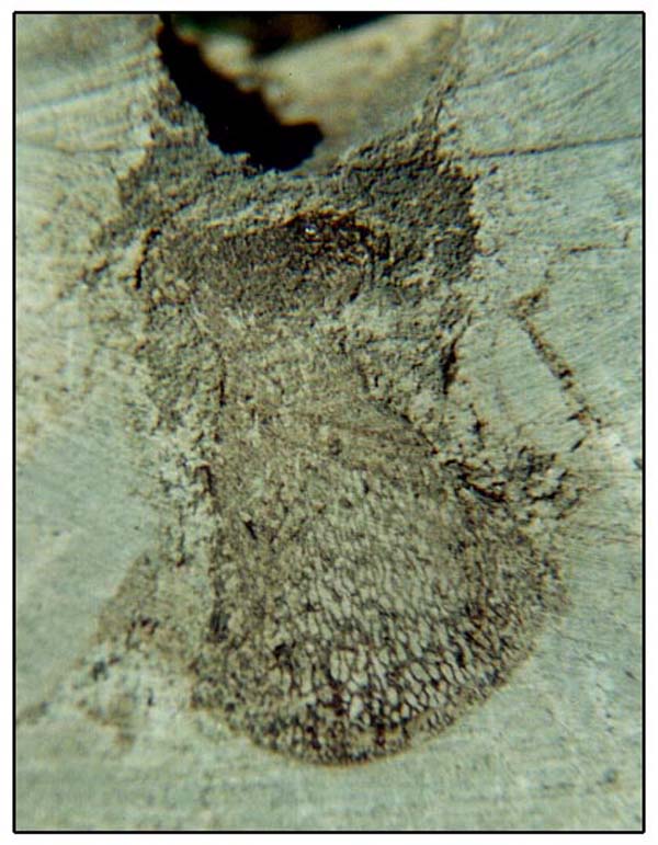
Figure 17. Close-up view of indented area of Figure 16. This is
the only example found to date of such cellular structure in an
inclusion. Inclusion is 4cm high x 2.5cm wide.
Diagenetic Orientation of Indentations. It seems likely that understanding the process of formation of the indented concretions will be assisted by knowledge of the orientation of the indentation during formation. Unfortunately, only two indented concretions that were unequivocally located in situ in bedrock have been found. In both cases the axis of the indentation was horizontal.
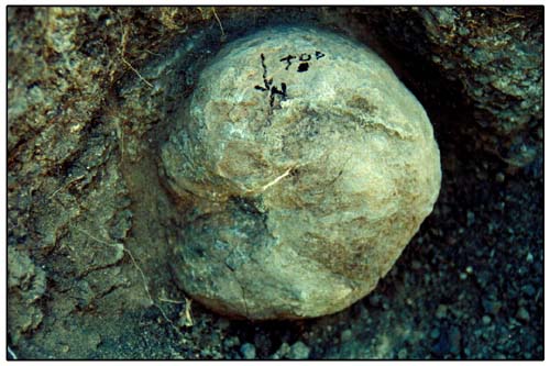
Figure 18. An indented concretion in situ in bedrock. The concretion is embedded in the side wall of an arroyo eroded into the Tununk shale. Top of concretion is marked. Arrow points approximately North.
Concretions without indentations occur in the same area as the indented concretions. They have not been found outside that area. They are significantly less numerous than the indented concretions. Based on the few unindented concretions that have been opened, the interior crystal veins do not reach the surface of the concretion and black inclusions do not occur.
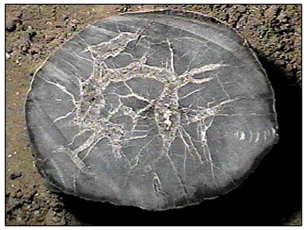
Figure 19. Cross section view of unindented concretion.
Woody Concretions. Concretions containing petrified wood occur in the same area as the indented and unindented concretions. They have not been found outside that area. They are approximately one half as numerous than the indented concretions. They are very susceptible to weathering and are frequently found nearly disintegrated.
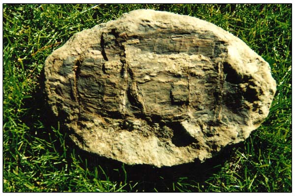
Figure 20. Woody concretion that was split by weathering. Split is parallel to long axis of concretion and divides it into two approximately equal parts. Dimensions are 25 x 16 x 7cm.
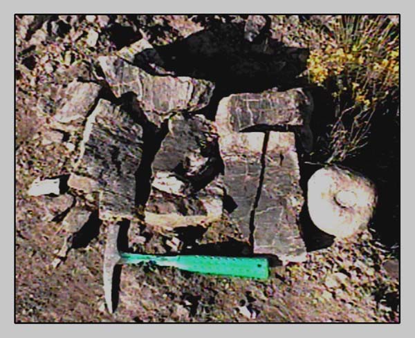
Figure 21. Typical woody concretion disintegrated by weathering.. Thin sections from this wood identified as Paraphyllanthoxylon. Species is probably utahensis. (Identification via Email from Dr. Steven Manchester) P.utahensis has been previously reported only from the 8 to 16 million year older Cedar Mountain Formation (Tidwell, 1998, p46, 223 -Thayne et al, 1983).

Figure 22. Petrified wood from disintegrated concretion with animal boreholes filled with white crystalline material. Specimen is 9 x 6.5 cm.

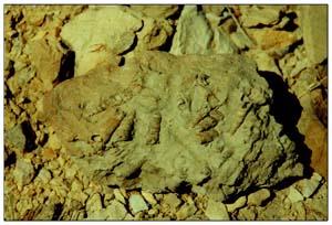
Figure 23. Woody concretion with wood partially exposed by weathering. Note apparent branch scars.
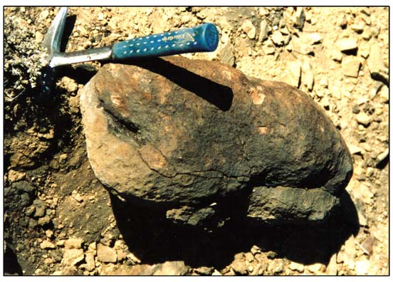
Figure 24. Probable woody concretion with elongated indentations. Classification as woody is based on similarity to many partially disintegrated woody concretions and apparent petrified wood visible in indentation at end.
Petrified wood not in concretions.
Fragments of petrified wood with dimensions up to 20cm are scattered
over the surface of the study area. Compared to the wood from
disintegrated concretions, the wood is significantly harder and
more dense. The exterior color is tan/brown. In some cases the
fragments can be reassembled into logs (with some pieces missing)
up to 75cm long. None of these wood fragments have been found
in situ and we cannot eliminate the possibility
that the fragments have been eroded from a strata which previously
overlaid the Tununk Shale. This wood has not been cross-sectioned
or otherwise identified as to taxonomy.

Figure 25. Side and cross-section views of typical petrified wood
from study area.
Flattened Concretions. A small number of flattened concretions - round in outline, 25 to 50cm in diameter, 5 to 10cm thick, were found in the study area. They appear to weather out of the Tununk Shale near the lower limit of the strata containing the indented concretions.
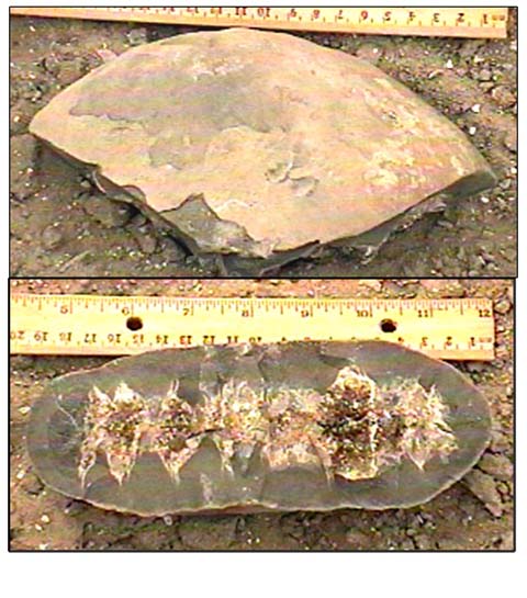
Figure 26. Side and cross-section views of flattened concretion
from study area.
Basis of identification. Our identification of the large scale stratigraphy of the study area is based on Witkind (1980) and is confirmed by comparison with the stratigraphy and measured sections in Balsley (1969), Molenaar et al (1990) and Riemersma (1989).

Figure 27. Overview of northern one-third of study area. View from west. Unusual concretions occur in range of low hills below Ferron Sandstone cliff.
Figure 28. Closer view of northwest end of study area. Unusual concretions weather out of low hill in center-to-right foreground(Arrow). Hill is capped by sandstone shown in Figure 29.
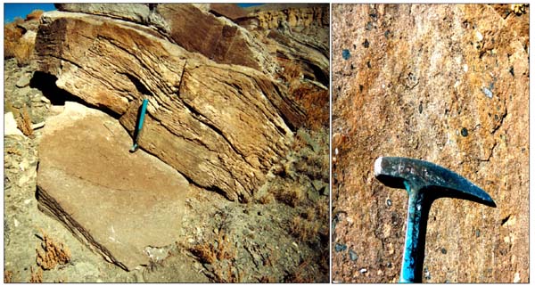
Figure 29. Two views of the sandstone layer that caps hills containing concretions. Photo made at northwest end of study area. Distorted bedding (left) and pebbles in sandstone (right) indicate high energy environment.
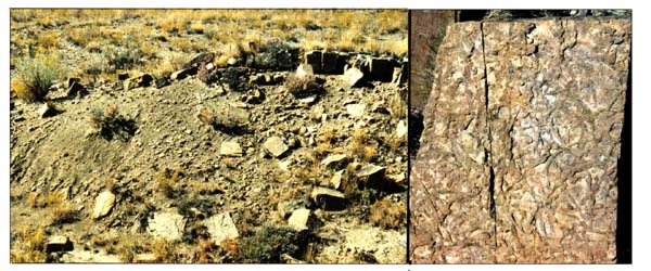
Figure 30. Two views of sandstone layer that caps hills containing concretions. . Photo made at center of study area. (This sandstone layer believed to be the same as the layer in Figure 29.) Even bedding (left) and well preserved bioturbation (right) indicate environment with lower energy than that at north end. Bioturbation is due to Ophiomorpha and/or Thalassinoides.
Figure 31. (Below)
Aerial photo of area producing unusual concretions. (From NAPP
5846-92.) Red arrows indicate range of low hills where concretions
originate. A points to location of Figs. 28,29 - B points to location
of Figure 30. 
Figure 32. Geologic Map of area where unusual concretions originate. From Witkind (1980). Map is scaled to match aerial photo above. The blue arrows connect corresponding features on the two Figures. Heavy blue lines indicate location of range of low hills where concretions originate. Geologic strata key assigned by Witkind: Kmu(Light yellow)="Unamed Upper Shale"; Kmf(Green)= Ferron Sandstone; Kmt(Yellow/Green)=Tunuk Shale; Kdc(Light Blue/Green)=Undifferentiated Dakota SS & Cedar Mountain Formation, Qal=Quarternary Alluvium.
The unusual concretions described in this report are found in an area a few hundred meters wide and about 3.2km (2 miles) long located on the northeast flank of the San Rafael Swell. The concretions originate from the southwest facing slopes of a range of low hills. Many of the concretions are found on the slopes where they originated. Some have migrated to level areas at the bottom of the slope and others are found in arroyos draining the hills.
The range of hills producing the concretions is located in the Upper Cretaceous (Turonian) Tununk Shale Member of the Mancos Shale. The range lies parallel to, and a few hundred meters to the southwest of, a high cliff formed by the lower unit of the Ferron Sandstone.
The slope producing the concretions is composed of easily weathered gray shale. The shale is capped by a 1/2 to 2m thick layer of resistant tan/gray sandstone. The capping sandstone is generally darker in color and coarser in texture than other sandstone layers in the Tununk. The capping layer grades from semi-conglomeratic and complexly cross bedded at the northwest to sandy, evenly bedded, and strongly bioturbated at the center of the range. It is not well exposed, and thus is not here described in the southeast end of the range.
Measured sections have not been made in the study area, but it is estimated that the capping sandstone lies 20 to 50 meters (vertically) lower than the lowest part of the Ferron Sandstone. The shale layer containing the concretions is estimated to be 10 to 20 meters thick. The shale layer is underlain by a 1/2m thick layer of light tan, fine grained sandstone that is similar to many other layers in the Tununk.
Correlations to previously named strata. Because the capping sandstone layer seemed to be so closely associated with the unusual concretions, and because it was distinctive, we searched the literature in an effort to find if other authors had described it.
The following quotes are from Riemersma (1989). (Page1) "A distinctive offshore deposit is a medium-grained sandstone of the Woodside unit, contained within the Tununk Shale. These sandstones were influenced and possibly deposited by episodic storm currents." (Page 6): "The Tununk Shale Member records the first major marine transgression of the Upper Cretaceous in Utah. A 10 meter thick siltstone and sandstone interval is contained within (gradational upper and lower contacts) the Tununk Shale along the east flank of the San Rafael Swell. This interval was first termed the Woodside unit of the Ferron Sandstone by Cotter (1975). However, studies presented here indicate that the Woodside unit is 25 meters below the Ferron (at sections 6 and 7) and does not appear to be related to Ferron deposition; thus it is better placed within the Tununk Shale Member." [Author's note: Reimersma's Sections 6 & 7 are located approximately 24km (15miles) west of the area of this report.)
On Page 15 Riemersma states, "The Woodside unit is exposed
as a number of thin (<1meter) fine- to medium- grained sandstone
beds which weather as benches within the Tununk Shale (Fig. 7)."
[Author's note: Figure 7 is a photo of a sandstone bed appearing
very similar to our Figure 30. The caption to Riemersma's Figure
7 identifies the location of the sandstone bed in the photo as
his section 13, which is 3 to 5 miles southeast of the area of
this report.] "Sandstone beds are commonly bioturbated and
fossiliferous, occasionally trough cross-bedded and separated
by up to 6 meters of bioturbated siltstone."
On Page 18, Figure 8, Riemersma presents cross-sections through
the Ferron and Tununk Members at his locations 5 through 20. These
cross-sections show the Woodside Unit present at location 12 and
at other locations to the southeast. The Woodside is absent at
location 11 and other locations to the northwest. The study area
of this report is located between locations 11 and 12.
In a detailed cross-section in his Figure 9, Page 19, Riemersma indicates that a bioturbated sandstone)(BSS) facies located 8meters below the top of the Woodside Unit contains concretions at the northwest end of the deposit (southeast of the study area). He does not further describe any concretions that occur in the BSS facies. He does describe (Page 21) concretions that occur in a transitional siltstone facies(TBS), apparently a few miles to the southeast of the study area, as follows, "Large brown concretionary masses are commonly contained within the facies. Concretions, occasionally septarian, are up to 1.5 meters in diameter and appear to be diagenetically associated with thick accumulations of bivalves (Exogyra)."
Starting on Page 127 Riemersma discusses the concretions found
in the Ferron Sandstone in detail. These discussions do not appear
to relate directly to the concretions that are the subject of
this report.
Riemersma concludes his description (Page 34) of the Woodside
Unit as follows, "A complete understanding of the depositional
history of the Woodside unit is hampered by an absence of east-west
exposures and uncertainty of the location, orientation and type
of shoreline." (Emphasis added to above sentence by present
author.) "Fouch et al. (1983) postulate a Tununk age shoreline
in extreme western Utah some 70 kilometers from the northernmost
outcrop of the Woodside sandstone. Though the eastern and western
extent of the unit is unknown, the Woodside unit appears to be
an isolated offshore sandstone unit pinching out to the northwest
and southeast. The unit does not appear to be part of a progradational
shoreface sequence. The gradational upper and lower boundary with
the Tununk Shale, and the absence of a coarse-grained lag suggest
that major erosional conformities are not present."
In all, Riemersma devotes 22 pages (out of a total of 137) to
the Woodside Unit. In studying this data, we have found nothing
contradicting the hypothesis that the strata producing the concretions
are a correlate or an extension of the Woodside unit.
Molenaar and Cobban (1991) describe the "Coon Spring Sandstone
Bed of the Tununk Member." Their description of the units
of the Coon Spring Bed seem to match Riemersma's description of
the Woodside Unit in the following aspects.
* Geographic location. Both authors describe a strata that extends
from the southeast and ending at, or just south of, the location
of this study. (Stratigraphic location: Thirty to fifty meters
below the bottom of the Ferron Sandstone. (Included chart)).
* Bioturbation. Both authors describe bioturbation by Ophiomorpha
and Thallasinoides.
* Concretions. Both authors describe large concretions to 1.5m
diameter.
* Both authors state that the depositional conditions of the strata
are incompletely understood.
In our studies we have seen nothing contradicting the idea that the Coon Spring Bed is closely related to the Woodside Unit and to the strata that produce the unusual concretions.
The authors believe that the following
unusual features of the study area merit further investigation.
* The occurrence, in a relatively small area, of a large number
of concretions with one or more indentations. The indentations
of all the concretions are of similar appearance. To the authors
knowledge, no similar indentations have been previously described.
* The occurrence of, in a location of marine origin and co-located
with the above concretions, a significant amount of petrified
wood. The wood has been identified as a species previously reported
only from a strata that is 8 to 16 million years older than the
strata under study. Most of the wood is contained within concretions,
but some that has not yet been identified might be of a different
taxon.
* The indented concretions contain small inclusions which have
not been cross-sectioned, but which resemble, at least in color,
the petrified wood found in the woody concretions.
* The occurrence of the above phenomena closely associated with
a sandstone layer which appears related to a rock layer previously
reported by two workers as being of incompletely understood origin.
The most difficult question in further investigation of the area are connected with understanding of the mechanism of formation of the indentations.
Most authors agree on the following general
statements:
* Concretions are formed around some object foreign to the sediments
that surround them. The foreign object is often a fossil.
* Concretions form soon after the sediment is deposited, and usually
in shallow water.
* Early in their formation concretions pass through a stage of
gel-like composition.
* Concretions with septarian-like veins are formed when a gas
is formed within the gel-like mass. The gas expands to cause cracks
in the gel which are then filled with liquids from which the crystals
precipitate.
In our search the publication describing
concretions which most closely resemble the indented concretions
(Zangeri et al, 1969, Pages 105-109) describes concretions in
which gas pressure has been built up, then escaped, producing
a brecciated interior and a collapsed upper surface. The edges
of the collapsed area in the concretions described by Zangeri
are angular, rather than showing the smooth curve of the concretions
of this report, and the collapsed areas are located on the top
(and sometimes the bottom) of the concretions, not on the sides
as with the indentations we have found.
We hypothesize the indentations in the concretions in the study
area were formed as follows:
* Gas formed inside the concretions while they were in a gel-like
state.
* After the gas pressure had inflated the concretion the gas escaped,
or was reabsorbed slowly, allowing the "rind" of the
gel to be bent gently rather than brecciated.
* We cannot offer an explanation of the mechanism that might have
caused the presumed slow escape/absorption. Observations to date
indicate that the phenomena that caused the indentations acted
at the side of the concretion, but this may be contradicted by
further field work.
* Observation fosters the feeling that the formation of the indentations
was affected by the black inclusions which occur in close association
with them.
Another interesting phenomenon is the
appearance of large amounts of petrified wood in the Tununk Shale.
The Tununk is a marine deposit - one authority places the nearest
shoreline, at the time of deposit of the petrified wood, at 70
kilometers from the site . Some amount of wood might become waterlogged
and sink to the bottom in any marine environment, but the amount
in the study area exceeds what we would expect. Thus, the amount
of wood present suggests a very near-shore environment and this
is borne out by the coarse-grained, nearly conglomeratic strata
overlying the study area.
Further investigation of the study area
appears capable of yielding new information about:
* The mechanism of formation of the indentations.
* The general mechanism of formation of concretions.
* Depositional environment of the strata in which the concretions
and petrified wood occur.
* Evolution of the genus paraphyllanthoxylon.
PLANS FOR THE YEAR 2000 FIELD SEASON
Evaluation of further data from this study is critically dependent on continuation of the excellent help and advice the authors have received from the academic community.
The authors intend to accomplish as much
as possible of the following:
* Conduct a search the study area for concretions in situ.
* Make a census, including description and map location, of all
indented, nonindented, and woody concretions and non-concreted
petrified wood exposed in study area.
* Continue search in nearby strata that are similar to study area
to insure that the full extent of the deposit has been determined.
* Dissection and thin-sectioning of all types of concretions.
* Measurement of stratigraphic sections of study area at northwest,
center, and southeast locations.
Balsley, John K., 1969, Origin of Fossiliferous Concretions In The Ferron Sandstone, Southeastern Utah, Master's Thesis, Univ. of Utah, Department of Geology
Hintze, Lehi F. 1988. Geologic History of Utah. Brigham Young University Geology Studies Special Publication. p 54-55.
Molenaar, C.M. and Cobban, W.A. 1990. Middle Cretaceous Stratigraphy on the South and East Sides of the Uinta Basin, Northeastern Utah and Northwestern Colorado. USGS Bulletin 1787-P.
NAPP 5846-92. 1963. USGS National Aerial Photo Project, Photo # 5486-92.
Riemersma, P.E., 1989, SEDIMENTOLOGY AND DEPOSITIONAL HISTORY OF THE LOWER FERRON SANDSTONE AND RELATED MEMBERS OF THE MANCOS SHALE FORMATION, EAST-CENTRAL UTAH, Master's Thesis, Univ. of Utah, Department of Geology and Geophysics.
Thayne, G.F et al, 1983. Flora of the lower Cretaceous Cedar Mountain Formation of Utah and Colorado, Part 1. Paraphyllanthoxylon utahense. The Great Basin Naturalist 43-3.
Tidwell, W.D. 1998. Common Fossil Plants of Western North America, Second Edition. Smithsonian Institution Press.
Witkind, Irving J. 1980. Reconnaissance Geologic Map of the Mounds Quadrangle, Carbon and Emery Counties, Utah. USGS Miscellaneous Investigations Series Map I-1202.

