
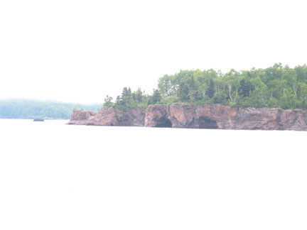
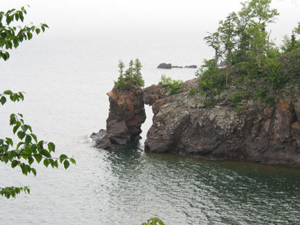
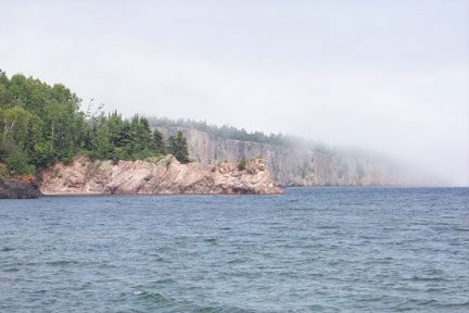
| These photos show some of the additional wonder of the
geology of Minnesota. These structures are in Tettegouche State Park, a few miles northease of
Silver Bay. The formation of sea caves (right) and sea arches (lower
left and right) are landforms expected to be in ocean environments but
because of the size of the lake and the igneous rocks on the North
Shore they are features found in Minnesota. A sea cave forms when the
inside part of a bay is undercut by water erosion faster than the
point. If caves on opposite sides of the point meet a sea arch is
formed. Given more time the arch will collapse and form a sea
stack. The remains of a sea stack can be seen in the lower lower photos
that are small "islands" of rock at the end of the point to the
southeast of the arch. The rugges cliffs of the Park are a result of the midcontent rift that flows through Lake Superior, along the St. Croix River through the middle of Iowa into Nebraska and Kansas. The rift formed a volcanic fissure eruption of basaltic magma that hardened into the basalt, diabase and gabbro rock of Lake Superior's North Shore as well as the basalt rocks at Interstate State Park. The glaciers that left Lake Duluth (now at a lower water level called Lake Superior) exposed the rock and presented some of the features of the lake. As a result of either the glaciers or other geologic processes the bedrock has tilted slightly toward the lake. |
 |
 |
 |
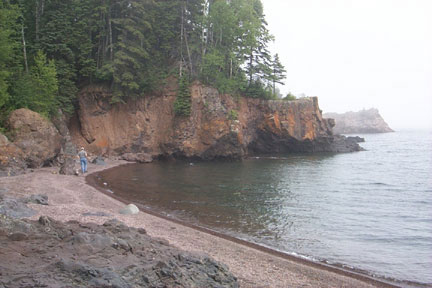
| Each point is actively being
eroded by the wave action. As the erosion causes small parts of
the cliffs to be broken away the waves carry them to the bays and
deposit them. These beach deposits causes the bay to be built up over
time. A general term for deposits piled in any manner in a marine
environment is accretion. The accretion in a bay combined with the
erosion of a point causes a smoothing of the shoreline. The wave action
will smooth the rocks that are broken away from the bedrock. As the
rocks roll and bang into each other the rough edges become rounded and
form the soft beach sands or pebbles. |
The cliffs in the lower photo
form Shovel Point. The bedrock of the cliffs is rhyolite, a reddish
fine grained rock of granitic magma. Theses cliffs and those of
Palisade Head (the hightest point above the lake on the shore) are both
great rock climbing opportunities in the Park. Palisade Head bedrock is
a balaltic magma rock between gabbro and basalt called diabase. |
 |
 |
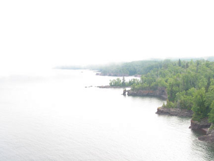
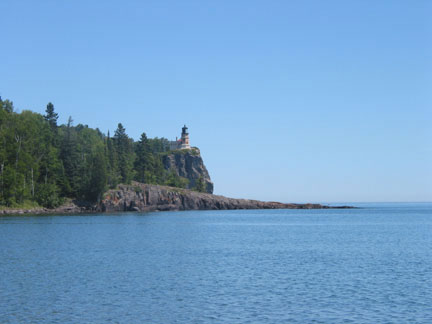
| In another example of a sharp cliff in Minnesota we can see
the Split Rock Lighthouse at Split Rock State Park. The lighthouse was
constructed as a result of ships crashing into the shore or nearby
"sunken islands" in fog or stormy weather. As you can see in the photos
above fog on the water is possible even when it is clear on the land.
Fog commonly forms over the water because it is much colder than the
land. The water of Lake Superior stays very cold even at the end of a
hot summer the lake temperature only a few feet from shore is seldom
more than 50°F. The lighthouse is now of little use because of improved global positioning satillite (GPS) technology that can tell ship captains the ship's positon better than any lighthouse. The high cliffs of anorthosite meant that the lighthouse did not need to be very tall in order to send the light signal. The shoreline at this point of the lake is much smoother than further North and much of the "beach" is covered with rocks about 5 inches in diameter. |
 |
 |
 |
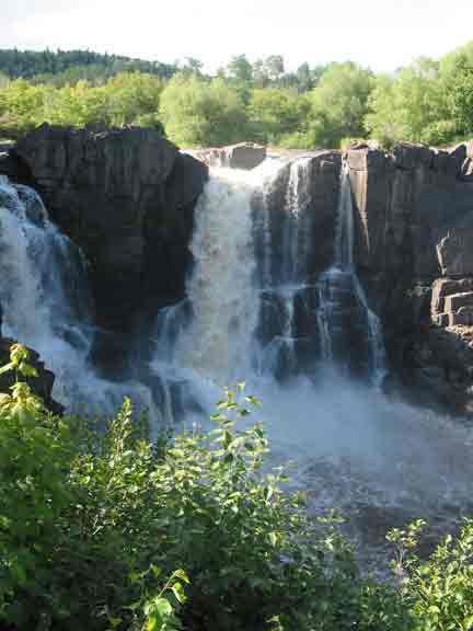
| Pigeon River water falls at Grand Portage and is part of Grand Portage State Park. The Pigeon River
is the dividing line between the United States and Canada between Lake
Superior and Lake of The Woods. The hard
upper rock is diabase dike, a rock of basaltic magma composition
that
is intermediate in composition between gabbro and basalt. A dike is an
intrusion of magma across (discordant) layers of country (already
present) rock. In
this case the diabase is formed in an intermediate process between fast
(basalt) and slow (gabbro) cooling. A structure similar to a dike but parallel to the country rock is a sill. A sill is a tabular (table like) structure that is concordant (lies parallel to the layers or original rock). Other examples of discordant rock structures are laccoliths and batholiths. In each of these examples the molten rock intrudes (squeezes into) cracks, seams or joints in the original rock. The underlying rock is a soft shale1 that errodes easily and leaves the waterfalls. Grand Portage in French means "The Great Carrying Place". The Pigeon River near the lake has nearly 20 miles of falls and rapids that make navagation impossible so the early French traders and local Native Americans would have to carry their canoes around the falls on trips from Lake Superior to other areas in what is now the Boundary Water Canoe Area (BWCA) and the Quetico Provincial Park (Candada). The falls are estimated to be between 100 and 130 feet high with an average water transportation of 3200 gallons per second. In the winter ice forms a sheet from 10 to 20 feet thick over the top of the rocks as the river continues to carry water to the lake. |
 |


