
 |
 |
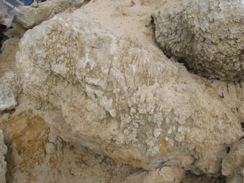
| In a close-up view of one of the sandstone "boulders" the
almost sugar like quality is apparent. Clumps of the damp sandstone can
be pulled from the thick layer but it easily crumbles in your
fingers. The very rounded and smooth nature of the sand grain
indicate a long
period of transport and erosion before it was deposited here. The
absence of fossils and plant material are evidence of a beach
environment and great erosion of granitic (the source of the quartz
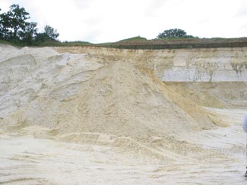
sand) material to produce this thick layer of sandstone. Sand is deposited in beach environments, near the shore as larger pieces fall out of the water with the reduced velocity. Further from shore mud (which becomes shale) is deposited as mud will stay suspended in much lower velocity currents. The shale at the top of this formation indicates that the water at this location was getting deeper overtime because the shale (mud) is being deposited in the far shore (deeper) areas after the sand was deposited in the near shore (shallow) areas. The sand from this quarry is being used as animal bedding or for fill in building construction. In other places in Minnesota the same formation is used for sandpaper, glass making and as frac sand for increasing the production of oil wells. |
 |
 |
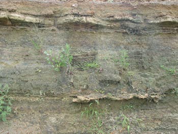 |
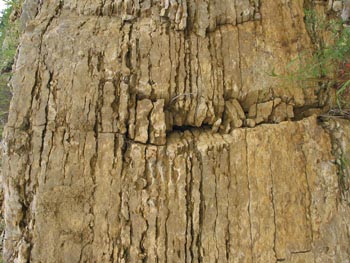
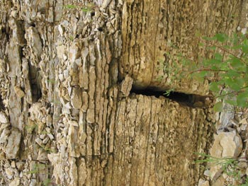
| "The formation in the photos above is the Glenwood shale. The
formation contains some fossils of small marine life. Shale is
basically compacted mud with the fossils forming imprints in the mud as
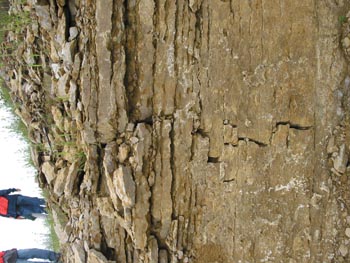
it turns to a soft dark green to black rock. The photo at the right and those below show the Platteville limestone. At the center of each of these photos there is a natural joint in the rock. These joints are not due to any human activity but are the result of natural cracking in the rock layers. Notice in particular the photo at the bottom right the size of the joint. It is places like this that are the start of sinkholes and caves that populate so much of this area of Minnesota. Water from rain or melting snow will funnel into these joints and dissolve some of the rock. As the rock dissolves the cracks get bigger, eventually forming caves and sinkholes. Notice the uneven thickness of the layers in the limestone. This feature is often used by builders to keep walls more stable by interlocking the sizes. The layering is a function of the deposition of the limestone. Limestone is essentially calcium carbonate, the remains of marine animal shells. As the shells dissolve in the water and then re-precipitate the limestone rock is formed. The formation goes in cycles with a thin layer of shale or other similar types of rock between the layers of limestone. The thickness of the layers is telling a story of how the rock was formed. In times of great amounts of animal life the rocks are thicker and when there is not so much life the layers of rock are thin. We can observe situations that are similar to this today that are related to the depth of the water. The relationship of the thin and thick layers of rock then tell us that not only was this area covered by a sea or ocean, but that the depth changed over time providing the different thicknesses of the rock layers. |
 |
 |
 |
1.
MN DNR 2004 Minerals Education Workshop guide pg. 5


 Next
Next