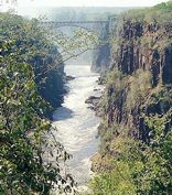
The Victoria Falls - Zimbabwe
The Victoria Falls constitutes one of the most spectacular natural wonders of the world. The Local people call it "Mosi-oa-Tunya" -- the smoke that thunders and the Falls are remarkable.
There is a magic about them manifested in the towering column of spray when the river is high, the thunder of the falling water, the terrifying abyss and tranquil lagoons upstream in which hippo and deadly crocodiles lurk.
The Victoria falls is 1 708 meters wide, making it the largest curtain of water in the world. It drops between 90m and 107m into the Zambezi Gorge and an average of 550,000 cubic metres of water plummet over the edge every minute.
Remarkably preserved in its natural state, Victoria falls inspires visitors as much today as it did David Livingstone in the 1860's. The falls and the surrounding area have been declared National Parks and a World Heritage Site, thus preserving the area from excessive commercialisation.
Seasons:
The river's annual flood season is February to May with a peak in April. The spray from the falls typically rises to a height of over 400 metres (1,300 ft), and sometimes even twice as high, and is visible from up to 50 km (30 miles) away.
During the flood season, however, it is impossible to see the foot of the falls and most of its face, and the walks along the cliff opposite it are in a constant shower and shrouded in mist. Close to the edge of the cliff, spray shoots upward like inverted rain, especially at Zambia's Knife-Edge Bridge.
As the dry season takes effect, the islets on the crest become wider and more numerous, and in September to January up to half of the rocky face of the falls may become dry and the bottom of the First Gorge can be seen along most of its length.
The minimum flow, which occurs in November, is around a tenth of the April figure.
Towns
Victoria Falls town (in Zimbabwe) lies on the southern bank of the Zambezi River at the eastern end of the Victoria Falls themselves. Victoria Falls Airport is 18 km south of the town and has international services to Johannesburg and Namibia.
Livingstone (in Zambia) is a historic colonial city and tourism centre for Victoria Falls lying 10 km south on the Zambezi River, and a border town with road and rail connections to Zimbabwe on the other side of the Falls. The Airport has connections to Lusaka and Johannesburg in South Africa.
National Parks
Open to visitors throughout the year, the Victoria Falls National Park in north-western Zimbabwe protects the south and east bank of the Zambezi River. It covers 23.4 km˛ extending from the larger Zambezi National Park about 6 km above the falls to about 12 km below the falls.
A notable feature of the park is the rainforest which grows in the spray of the falls, including ferns, palms, liana vines, and a number of trees such as mahogany not seen elsewhere in the region.
Mosi-oa-Tunya National Park in Zambia is an UNESCO World Heritage site and is twinned to the Victoria Falls National Park on the Zimbabwean side. The Park covers 66 km˛ (25.5 square miles) from below the falls in a north-west arc along about 20 km of the Zambian river bank.
It froms the south-western boundary of Livingstone and has two main sections, a wildlife park at its north-western end and the land adjacent to the Victoria Falls.
The national parks contain abundant wildlife including sizable populations of elephant, buffalo, giraffe, zebra, and a variety of antelope.
Activities
A number of activities can be undertaken. The 'Flight of Angels' provides a fabulous vista of the falls, the upstream river and its many islands and for the more adventurous there is microlighting with stunning views of the Fall.
Rafting the wild rapids below the Falls is a very popular adventure. Visitors can also kayak, canoe, fish, go on guided walking safaris, ride on horseback and lunch on Livingstone's Island.
Game viewing via boat or open vehicles is a popular activity above the falls or in in Chobe in Botswana.
Location: Victoria Falls, Zimbabwe
KING'S PARK - Perth Australia
Kings Park is a 4.06 square kilometres (1,003 acres) park located on the western edge of Perth, Western Australia central business district. The park is a mixture of grassed parkland, botanical gardens and natural bushland on Mount Eliza.
Kings Park and Botanic Garden overlooks the Swan River and Darling Range and showcases an outstanding collection of Western Australia flora. It is a popular place for picnics, pleasant walks, cultural and ceremonial events.
Nearly two thirds of the Park is natural bushland containing 319 species of native plants and around 80 bird species. The balance of the Park is made up of superbly cultivated gardens and open recreational areas.
For Western Australians and for the many interstate and international visitors, Kings Park and Botanic Garden is a place of inspiration, relaxation, recreation and wonder. The Botanic Gardens and Parks Authority manages Kings Park and Botanic Garden in accordance with the Kings Park and Botanic Garden Management Plan 2004-2009, to ensure the conservation of native biological diversity and cultural heritage icons, while providing for the diverse range of visitor interests.
Sent in by Robyn, Perth Australia
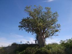
The term bushland usually refers to an area that has only a sparse flora and fauna. This term was first used to describe the harsh Australian Outback and the red semi-desert that covers a significant part of the inner continent. The soil is usually very salty and therefore only specialized plants and animals can survive. Human survival in the bushlands has a whole mythology evolving around it, with the legendary stories of trackers and bushrangers deeply entrenched in Australian folklore. Probably the best survivors out there are the Aboriginals, who have learned how to blend in with nature and become a part of it.
Great Barrier Reef
One of Australia's most remarkable natural gifts, the Great Barrier Reef is blessed with the breathtaking beauty of the world's largest coral reef. The reef contains an abundance of marine life and comprises of over 3000 individual reef systems and coral cays and literally hundreds of picturesque tropical islands with some of the worlds most beautiful sun-soaked, golden beaches. More Information
Sent in by Jan
KAKADU NATIONAL PARK
Kakadu National Park an Australian Natural Icon covers almost 20,000 square kms and is 257 kms East of Darwin the capital city of the Northern Territory, Australia. Kakadu National Park is a World Heritage listed area that has been listed for it's cultural and natural heritage and Kakadu is the largest terrestrial national park in Australia. Life in the park depends on the water, also in respect to the tropical monsoon climate that produces the downpours of the tropical humidity of the "wet" season, and the milder weather of the "dry" season.
Kakadu is the second largest national park in the world and and is home to approximate number of species: Mammals: 62, Reptiles: 123+, Birds: 280, Freshwater Fish: 51, Insects: 10,000, Frogs: 25, Plants: 1,275. (many are rare and occur only in Kakadu)
More information
Sent in by Jan, Australia.
Los Glaciares National Park, ARGENTINA
The Los Glaciares National Park is located in the Southwest of the Province of Santa Cruz, bordering with Chile. There are 47 glaciers in the Park. Some of them are the Upsala, Spegazzini, Mayo, Perito Moreno -all of them flowing into the Lago Argentino (Argentino Lake)-, Onelli, Ameghino and Fr�as. The Argentino, Roca and Viedma lakes are also within the Park. Tourists from all over the world come to this place attracted by the glaciers, the outdoor activities and the fauna.
The first settlers were the AoniKenk -actually known as "tehuelches". They used to hunt guanacos and pick roots, seeds and herbs for food. The first sailors to arrive in these lands were Fitz Roy and Darwin. They came on the "Beagle". From that moment on, Luis Piedrabuena, Gardiner, Feilberg and Francisco Moreno visited the area.
The climate is cold and winds reach a speed of 120 km/h (75 miles per hour) during the spring and the summer. Therefore, it is important to be extremely careful when going along the local routes, as they are made of rubble and the snow and the ice sometimes become a big problem. Within the park, lenga is the most common tree as it is also in southern Argentina, where it rains quite frequently.
More information
Los Cardones National Park
The Cardones National Park wa screated on 20th November 1996, becoming the third National Park of the province of Salta,North west Argentina, that already had two forest gems: El Rey and Baritú National Parks.
Ir beautiful tall cacti that grow on the sides of its peaks(Trichocereus pasacana), are what give the national Park its name. Legend has it that according to the ancient population they are guards that control the valleys and mountains against the presence of intruders.
Its 64.117 ha. reserve a representative sector of the main Andes Biomas of northwest Argentina.It has an altitudinal difference that ranges from 2.600metres a.s.l in the bottom of the Tin-Tin Valley, up to5.226 metres a.s.l. in the Malcante Peak. It is limited mainly by the mountain chain and river valleys.
Climate
Most of the area has a purely arid climate: dry and warm with average winter temperatures of 11ŞC with minimums just below freezing, and average summer temperatures of 18şC with maximums of 30. Rainfal is few and far between, the annual average being less than 200mm which falls mainly in the summer (November to March)though it doesn't rain the same in all areas nor does it get the same quantity every year.Occasionally there can be snow fall in the valleys, and in the peaks the precipitation falls as hail.
Topografía and soil
There are three types of environment: That of the hills with their pronounced relieve of soliod rocks and roocky soil; that of the foothills and slopes, with more gentle slopes and acumulation of fluvial debris; and that of the lower depressions made ou of fine red dessert soil, salty and sandy brought down as river sediment.
The peaks shoe up for their variety of colours, ranging from several shades of red, blues purples and greens, and there are also many well conserved fossils remains of snails, algae, fish and dinosaurs
More Information on this Park
IGUAZU NATIONAL PARK, Misiones, Argentina
It was declared Natural Patrimony of the Humanity by the UNESCO. It comprises an area of 67.000 hectares, including its connected reservation.
It nearly constitutes the last exponent of the subtropical forest in the country and includes the world famous Iguazu Falls.
Its existence is aimed at the preservation of the already mentioned falls and of a neighbouring zone representative of the original forest surroundings of Misiones (before the deforestation carried out by men), last integral refuge of the regional flora and fauna.
This forest used to be an extension of the Brazilian southern forest.
The ground of the Iguazu National Park is reddish and its organic matter comes from the leaves and vegetation which grow densely in the region favoured by the high temperatures and heavy rains.
Its relief consists of light elevations of about 30 metres of height and gullies of about 60 m.a.s.l.in the falls
The Iguazu Falls make up a semicircle of aproximately 2700 metres consisting of 275 falls. Appart from the Garganta del Diablo (Devil's gorge), other well known falls are the Bozetti, Dos Hermanas (Two Sisters), San Martín, Adán and Eva, Tres Mosqueteros (Three Musketeers) and Rivadavia.
The park lodges more than 400 species of birds, about 2000 vegetal species and an immeasurable world of insects making of this ecosystem one of richest natural environments of the country.
It possesses interpretation paths and complete installations for the tourist, including footbridges to appreciate the astounding falls "from the inside"
You can also carry out several activities related to adventure tourism.
Langley
-not so much a park, more a local beauty spot
Downtown Langley, Greater Vancouver
Fronting the Fraser River to the north and Washington State to the south, Langley is located in the geographic centre of the Lower mainland, nestled between Surrey to the west and Abbotsford and the lush farmland of the Fraser Valley to the east. From Vancouver, it's less than an hour's drive east along Highway 1 or via Highway 7. Take a short trip across the Fraser River on the Albion Ferry which enables motorists to make a direct connection between Highway 7 on the north shore and Highway 1 on the south.
Named after Thomas Langley, a prominent Hudson's Bay Company director, Langley is considered to be the official birthplace of British Columbia. The colony of B.C was originally proclaimed here, at Fort Langley, although the capital moved from here to New Westminster, before finally settling at Victoria on Vancouver Island.
The valley land between the Fraser River and the Canada-US border ripples away like the wake behind a troller. Early settlers didn't have an easy go of it; the land was boggy and thick with mosquitoes in summer. But having come this far, they dug in, cleared the trees, farmed the land, and, in season, hunted and fished for wild game. You can still get a scent of those years as you pedal the backroads along the border of Surrey and Langley.
In the 1830s, the Hudson's Bay Company began to develop and farm approximately 810 hectares of land in the area known as Langley Prairie. Today, Langley has almost 40 percent of the total agricultural land in the Fraser Valley, giving agriculture a major role in the economy of the region. With more farms than any other municipality in BC, Langley has the largest number of horse farms, the largest number of rabbit farms, the most sheep, and almost half of the mushroom farms in the province.
Without a doubt, the most interesting and popular attraction in the Langley area is the Fort Langley National Historic Site. The fort, preserved and restored to its original 1850s' condition, is a gateway to British Columbia's early history. Visit the lovingly restored buildings of Fort Langley in the summer months, when the park's staff, dressed in period costumes of the era, go about their business blacksmithing, churning butter and making wagon wheels.
Population: 115,326
Location: Langley is located on Highway 1A, 31 miles (50 km) southeast of Vancouver.
National Parks in the UK
CANNOCK CHASE
In England and Wales , there is a huge variety of scenery and landscapes, from dramatic coasts to remote mountains. Those landscapes considered most valuable are designated as National Parks or Areas of Outstanding Natural Beauty (AONBs). These landscapes are protected by law and managed to maintain their special character for now and the future.
Cannock Chase was designated as an AONB in 1958 because of its beautiful landscape, its wildlife and its history. Cannock Chase is the largest surviving area of lowland heathland in the Midlands . Lowland heath is an internationally scarce and threatened wildlife habitat. The AONB also has extensive areas of forest and woodland along with areas of designed parkland, sand and gravel quarrying and mixed agriculture.
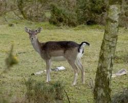
Cannock Chase and its associated animal and plant communities are part of an historic landscape dating back thousands of years. Wild deer still roam the Chase and are probably descended from the original herd introduced in Norman times for hunting purposes.
Once upon a time this vast area was the 'Happy Hunting' ground of Kings and Queens of England who came here to enjoy a good day's sport with local Lords and Ladies.
These day's the 26 square miles of Cannock Chase form an internationally acclaimed area of outstanding natural beauty, and the heathland, woodland and valley wetlands are decreed a site of special scientific interest. The rolling heathlands, some flat, others on higher ground, are the largest surviving heathland areas in the Midlands, as such, they provide valuable habitats for invertibrates, along with the rare Nightjar, Lizards and Adders and, important and unusual wildlife include the Cannock Chase berry, a magnificent herd of Fallow Deer and the Woodlark.
There is so much round here that is rare and green, the majestic woodlands, valley's and heathlands, provide an oasis right in the heartland of a great industrial town. A far cry from when the Chase was a private hunting ground for Kings, it is now a paradise for locals and visitors alike. Every corner you turn leads to some fresh delight, there are Bridleways, Forrestry Commission Trails and the Staffordshire Way runs right through.
During it's long history the Chase has been used for mining, charcoal and glass making also feature in it's history. The areas use as a Military Training Ground goes back to the 1870's. It is also known to have been used for training our troops prior to World War one and two.
A short distance away from Cannock Chase is Shugborough Hall, this exquisite mansion is home to the earls of Lichfield. This mansion home stands in beautiful grounds and contains a fine collection of furniture and other period treasures. The grounds are studded with classical follies such as the Arch of Hadrian, the Doric Temple and the Tower of the Winds.
Cosford Aerospace Museum is but a few miles along the M54 and from this point you can also reach two other great houses, Weston Park and Boscobel House.
Sent in by Pat B. April 2009
Great Smoky Mountain National Park
A Wondrous Diversity of Life
Ridge upon ridge of forest straddles the border between North Carolina and Tennessee in Great Smoky Mountains National Park. World renowned for its diversity of plant and animal life, the beauty of its ancient mountains, and the quality of its remnants of Southern Appalachian mountain culture, this is America’s most visited national park.
Wildlife
Most visitors come to the Smokies hoping to see a bear. Some 1,500 bears live in the park. From the big animals like bears, deer, and elk, down to microscopic organisms, the Smokies have the most biological diversity of any area in the world's temperate zone. The park is a sanctuary for a magnificent array of animal and plant life, all of which is protected for future generations to enjoy.
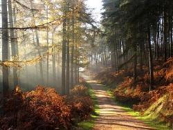
Autumn Leaf Season
The park usually experiences an autumn leaf season of several weeks as fall colors travel down the mountainsides from high elevation to low. Fall colors can typically be seen from October through early November in the park. However, the timing of the color change depends upon so many variables that the exact dates of "peak" season are impossible to predict in advance.
More Information
Mentioned by Lindalou, Alabama
Beautiful America, National Parks
Return to main page