


Rivington Village
Rivington Village is peaceful and tranquil and is the old heart of the parish that is outside the Lever Park area. Rivington Village Green is said to be a remnant of the former Anglo-Saxon Common where it was usual to build the houses around the common land. Rivington is said to be one of the “ington” settlements from 650AD.4) From 664 to 668 Chad was Bishop of York and his diocese extended from the North Sea to the Irish Sea and from the river Tees to the rivers Humber and Mersey, and he was renowned for travelling all over his diocese on foot. During this period of intense missionary activity in the North of England Saxon inhabitants of Rivington were baptized into the Christian faith.
Trough and Stocks
A stone water trough dated 1860 in place until the early 21st first century was situated at the lowest part of the green and was a relic of the horse transport days and was placed there after the rearrangement of the roads due to the construction of the reservoirs.
The stocks on the village green were previously sited in the garden of the Vicarage overlooking the road on the curve going to the church, until moved to the current location in the 1960s'. In centuries past the churchwarden and village constable patrolled the village and anyone disregarding the sanctity of the Sabbath could face being bound in the stocks. 5) 6) The village stocks have one stone inscribed T W 1719. A flag pole was once located on the green.
Existing Buildings
Rivington village is a conservation zone and was not part of Lord Leverhulme public park, it is the home of local residents.
On the left is the Vicarage rebuilt 1884.
On your right you have a Mill Hill cottages, the houses with gardens, one with an inscribed stone J.H. 1788 and the row behind, were originally named the School Houses as boarders from the Grammar School were taken in here.
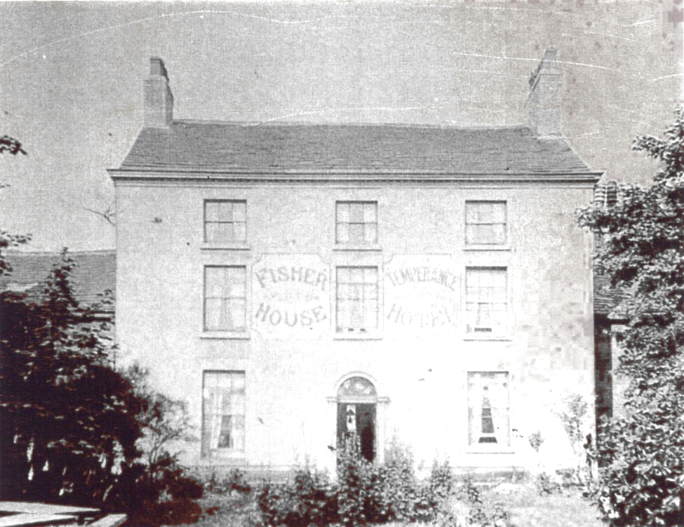
The track adjacent leads to Fisher House, a Georgian house with a walled garden, once home of the Rev. John Fisher, Vicar of Rivington from 1763 to 1813, a more recent inhabitant was Phoebe Hesketh who was a English poet, she died in 2005. The Georgian building was 'Fisher House Temperance Hotel' during the build of the resovoirs.
As you look toward the village green you will see the stocks, these were originally located in the Vicarage garden and placed on the green in the 1960s. There is a large house on your right that adjoins the stone cottages, this is known as School House and the cottages adjoining were once individual private homes but have since been converted into one. The cottage's to the left of School House are not as old as they appear. The door of the cottages closest to the Chapel was a former post office where there was once a traditional red telephone box located nearest the Chapel until 2005 and a Victorian post box was once located on the wall.
The Unitarian Chapel is dated 1703 on its date stone, walking through the Chapel yard to the left side of the Chapel will take you to the Tea Rooms, located in what was the Chapel’s School Room. The Rivington village Tea Room's have been a feature for many years and certainly worth a visit, the location is relaxed and dog friendly.
Chapel House sits on land leased for 2000 years by Robert Andrews to the Chapel Trustee's for the use of a Minister, 27 Oct. 1766.7)across the road is New Hall Barn which is currently planned for conversion to a house and was the former site of New Hall Farm.
Walking toward the reservoir to Horrobin Lane the view on your right is Rivington Anglican Church, founded 1566 and its Lynch Gate erected 1923, the Church was rebuilt in 1666 and greatly internally altered by 1861, its porch was added that year. The Church is an active Anglican place of worship. Additions have been added in recent years in keeping with its purpose as an active place of worship with regular services on Sundays.
There are old stones located at the entrance of the Church which were retrieved from Ridgmont House at Horwich in the 20th century, a former collection of the Ridgway family, which between 1907 and 1925 were used by Lord Leverhulme as garden ornaments. The stones are believed to be remains of the first Horwich Parish Church. The Church has a small bell house, although it does not contain a bell and is used as a tool shed by the Church grounds men.
Across the road there is the Village Hall which on the site of the old village Smithy, the Rivington Brass band practiced there from 1864 to 1884. The band is now the Rivington & Aldington Brass Band and has its own premises.
Standing further back is old Grammar School, rebuilt 1714. Walking further down Horrobin Lane toward the reservoirs you will see a car park, that is the site of the replacement Old Black A Moors and Bowling Green Pub, the original was demolished for the Upper Rivington Reservoir, the replacement was demolished in 1903, behind the car park is located the Rivington Bowling Green and Pavilion. Ahead of you are the Lower and Upper Rivington reservoirs.
Past Buildings

As you first enter the village, from Great House on Rivington Lane you passed over Hall Brook by crossing Croft Bridge, located there was once a house called Croft Gates, shown on early OS maps, there are no remains of it. The 1881 census shows the occupier as Betty Ball, a widow, then age 74.
Buildings that are known to have been rebuilt are the Vicarage, the Grammar School and the Anglican Church. Prior to the construction of the reservoirs between 1850 and 1857 there was little interest in the area, the area of the reservoirs had become known as the Lancashire Lake District by the Victorians. The first book to be published was the History of Rivington, by Thomas Hampson in 1893.

The original Inn was known as the
locally as the 'Black Lad' although it is recorded on maps as the
Black A Moor's, it was demolished c.1850 and its
land was taken for the upper Rivington reservoir.
A replacement public house and hotel were built
closer to the Church, which caused some controversy within
Temperance circles at the time, the new pub was called the Bowling
Green and the hotel given the name Black A Moor's Head Hotel, it was used during the
build of the reservoirs, this to was also demolished 1903 after
Liverpool Corporation complained of risks to the drinking water due
to issues with sewage treatment and close proximity to the water. New Hall Farm was demolished in 1905 and once
stood across from the Chapel, the remaining barn is being converted
to a house. At the time Liverpool Corporation did attempt to acquire
and demolish all buildings including school, chapel, church, every
home in the village and all farms in the catchment area, at
Rivington they did not succeed.
Entering the village on Rivington Lane from the direction of Great House Tea Rooms you cross a stream called Hall Brook, over Croft Bridge, you walk under the shadows of the tree's of Mill Dam Wood on your left, the area to your right is known as Mill Hill.

Within the deeds for the Pilkington family of Rivington Old Hall were once a mill and kiln for corn, mentioned in 1544 and again in 1611 8), all signs of the original Mill are long lost except in the name of the areas within the village being Mill Hill is now the site of Rivington Chapel.
A Short History of Rivington by Irvine, pg 120 identifies the land adjoining Mill Hill as Goosehey, being where School House was built in 1789 for the School Master, this is the larger building on the same row as the former post office. The name of Mill Hill had later been applied to a larger area extending to Croft Bridge, taking in the Victorian boarding houses then known as School houses, now named Mill Hill cottages.
Mill Dam wood is on the water course of Hall brook, behind the Vicarage, a Smithy operated a little further along where there is now the Village Hall.
In woods between croft bridge and the vicarage there is a ruin that is likely remains of a water wheel, a preindustrial source of power, the name indicates it also once had a dam, a pond was located next to Vicarage, likely created from the dam on the Hall Brook. Water Wheels were common place, often enclosed in their own covered stone building, almost every home had one. The Old Hall used theirs to churn butter. first OS Map there is what appears to be a pond, consistent with names given to those area's.
Spinning and bleaching were also once prominent activities in the
pre industrial revolution period, one located at Knoll woods, at the
River Douglas also operated a public house known as Tigers, it was
closed and demolished by 1868. In the 18th century Samuel Oldknow
of Anderton, a well known cotton manufacturer was connected to
Rivington Chapel.
Weaving was a common occupation in old Rivington, cottages and farms
frequently adapted for that purpose. Samuel Oldknow Jnr had in 1779
bought a number of Samuel Crompton of Bolton's spinning mules and by
1782 started to use the putting-out system of production in the
area, whereby raw cotton was distributed to spinners and yarn to
weavers who worked in their homes and workshops to return the
finished product to his factory for checking.
Club Day


This is an account of Club Day, a regular annual event at Rivington, with an usual method of deciding who was to be Mayor, a position that the locals did not take seriously. The fancy dress may be insensitive from a modern point of view, in the late Georgian and Victorian period Black faced minstrels were a hugely popular act in live performance and marionette shows. In this period the inhabitants knew little of people from Africa and Asian continent, except through books and music halls.
Further details at V & A
Press Report Bolton Chronicle 10th July 1858
John Moore, a blind fiddler was charged with causing a disturbance in Rivington Village on the morning of 25th of June.
C.J. Darbishire Esq. one of the Magistrates said that at 4.0 am. on that day he was awoken by a great disturbance and someone kicking at the door. He found nine men at the back door, one of whom had his face blacked was sitting on a form in the midst of them. The defendant had a squealing fiddle and was fiddling as hard as he could.
He told them to desist and go away, but they asked for some money for a benefit and then they would go. He eventually forced them off the premises. The defendant was drunk and he believed all the others were as well.
It was an old custom on the Eve of Club Day that the first man who got drunk was dignified with the title “Mayor of Rivington”. His worship was then plied with brandy and other spirits until he lost his senses. His face was blacked and he was carried on a shutter through the Village, money being demanded at different farms and other places to support the dignity and hospitality of the office, and eventually His Worship was tumbled into the Mill Dam.
A man had nearly died two or three years ago so that part of the procedure had been abandoned, Mr. Darbishire said it was a disgraceful custom and he was determined to suppress it.
In reply the fiddler said, “If I had known I was going to Mr. Darbishires I should not have gone with them. He was bound over to keep the peace.
It would appear that the practice had certainly annoyed the local J.P the pub went up for let a year later. Bolton Chronicle 19th February 1859: To be let, The Blackamoor’s Head in Rivington with Meadow and Pasture land and garden. Possession can be given in May. Contact J. Howarth, New Hall.

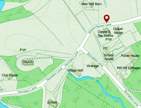
View Larger Map
Above was location of Black a'Moor Hotel, seen in the earlier photograph
Explanation
The coloured lines show the rights of way.
The following colours are used for the coloured lines:
solid red line: footpath;
solid fuchsia line: bridleway;
solid green line: restricted byway;
solid blue line: byway open to all traffic.
If you click on a coloured line, some details about that right of way will appear.
References
Copyright Paul Lacey 2010