
|
Fayette
and Westfield
Iowa Site Links: |
Of Westfield and Fayette, Iowa before the
Whites
MY PERSONAL OVERVIEW
BEFORE THE EUROPEAN INVASION,
THE IOWAY NATION
AND OTHER NATIVE AMERICANS LIVED IN THE COUNTY FOR HUNDREDS OF YEARS.
The
area which now includes Fayette County had been the settled land of a number native
cultures for several thousand years before their displacement by the invasion of the
European culture in the mid-1800's. European culture has survived only 150 years in
the area, with significant long term impact on the environmental quality.
MOST SETTLEMENTS WERE ALONG THE WATERWAYS.
In Fayette County, as with all the early European settlements, most of the major native
villages were located along streams for water, navigation and wildlife resources.
The river plains and valleys flooded and therefore offered a more fertile, easier to
cultivate, deeper soil for growing crops. The habitat variety supported a more
diversified and abundant source of useable plants and animals for the hunter, gather,
basic agricultural societies.
NATIVE AMERICANS WERE QUITE
SUCCESSFUL IN THE FAYETTE AREA. The land, water, air easily
sustained the native populations because of a relatively insignificant impact on the
overall environment. The population remained relatively low (2-6 per square mile, as
opposed to the 20-45 for early Europeans) due to limiting environmental factors and the
level of technology. Hunting was still with native chert (a form of high calcium
flint) points and knives, with snares and deadfalls and fishing with nets and by
hand. Agriculture still consisted of working small plots, hand tilled with wooden
hoes or small palm shaped chert hoes held in the hand or attached to various
handles. The native cultures were highly organized and had developed sophisticated
rituals and methods of surviving, utilizing the land's resources on a renewable, long term
basis. That was not planned, just the way the culture had developed within environmental
guidelines.
THE WHITE MIGRATION WAS RAPID AND
POWERFUL. With the arrival of the European culture in the late
1840's there was a rapid transition to a more sophisticated level of agriculture and
organized manufacturing. The ability to work iron, the ability to dam streams and
use oxen and draft horses for power, the ability to manufacture, the ability to plow
massive amounts of land and cut the trees in mass, the ability to mass migrate and
mass transport, the ability to domesticate plants and animals at a prolific rate.
EUROPEAN TECHNOLOGY AND LIFESTYLE
OVERTOOK THE COUNTY IN ABOUT TEN YEARS. There would be a rapid
impact on the land and water. In the span of years from about 1848-1860, the natives
would be displaced, the land would be surveyed, granted or purchased. Many European
style villages would spring up on the river bottoms, near trail waypoints or on a
knoll of prairie land. Farming would initially be in the hills and valleys as the true
tall or wet grass prairie to the west would be very difficult to work until better steel
tipped plows were developed around 1860. Whole families would rapidly move
into the area, migrating from anywhere east or from Europe, with the promise of new
land, new wealth, a new life.
the IowaY(EXTRACTED FROM THE IOWAY NATION SITE)
IOWAY HISTORY, AND THE MAKING OF TREATIES
Prehistory-1680s
The Iowa and related tribes like the Otoe, Missouria, and Hochunk (Winnebago) (and others like the Omaha) descended from Spirit Animal Clan ancestors in mythological times. They recognized an ancestral bond, as well as their separate tribal identity. Their sacred tales related the importance to their origin as a people of a place called Red Earth or Red Banks, apparently in modern-day Wisconsin. Archaeologists have recognized their common origins in a pottery-making culture the archaeologists call Oneota. The Oneota also were among the first to use red pipestone.
Oneota was a term coined by archaeologists, and is not the term used by the Ioway and their relatives for our ancestors. (See Oneota). Further proof of this relationship lies in the similarity of the languages of these peoples. The Ioway, Otoe, and Missouria languages are grouped together by linguists as "Chiwere," a term the Otoes used to refer to themselves.
The Ioway lived in ancestral lands in Iowa since time immemorial, in villages along the Missouri and Mississippi Rivers and their tributaries like the Upper Iowa River and the Iowa River. Occasional arguments might develop into small-scale battles, but war was a sport and a religious event rather than a necessity.
With the coming of the first French explorers, their world began to change. Wars to the east and increasing epidemics began to cause increased strife among the tribes of Iowa, especially between the Illini who were being pressed west by the Iroquois and the Hochunk (Winnebago). The Sioux were also being pushed south from Minnesota by the Ojibwa, and the Sauk and Fox (Meskwaki) were also being pushed from Michigan and Illinois into Iowa lands.
1680-1750
The Ioway were caught up in the turmoil of the times. Hard feelings developed among previous friends and relatives over territory and resources. Alliances were built and broken and built again. An increasing flow of nonIndian traders into Iowa lands made things worse, as the traders manipulated alliances and injuries to their advantage.
Soon it was apparent that Iowa lands were being looked upon as the territories of different foreign nations, such as the French, Spanish, and British. Not only were threats coming from the east, they were approaching from the west as well, with mounted warparties of the Padouca (Comanche and Apache) coming to gather slaves among the horse-poor prairie peoples for the Spanish in the Southwest.
1750-1815
The wars of the foreigners, the French and Indian war, the Revolutionary War, the War of 1812, swept the Iowa into the thick of intrigues and betrayals. Old friends now had become enemies, and the Ioway were decimated and alone. War was the law of the land. Finally, with the success of the Americans over their rivals, the foreigners (whitemen) were ready for peace so they could settle the lands they had won. First, they had to convince the Indians to stop fighting. It was ironic, since it was the white wars and disease which caused the intensity of competition and hatred between the Indian tribes at that time.
1815-1836-- And beyond: The making of treaties, and the making of white people
Treaties began to be pushed on the Indians by the foreigners. The treaties were made this way:
1. A treaty was made to recognize friendship between the U.S. and the tribe (For the Ioways, this was the Treaty of 1815)
2. The U.S. told tribes to stop fighting and make peace. To do this, the best way was to draw lines between the tribes so they would stay in their own territory. This was alien to Indian ways, because although village areas were considered to be owned by a tribe, the larger hunting territories were usually shared. The establishment of boundaries was supposed to make peace, but its real purpose became clear very soon-- in the whiteman's ways, you need to define and mark a piece of land and designate an "owner" so you can "buy" it from him and make it your own. (For the Ioways, this phase was marked by the Treaties of 1824, 1825, 1830, and 1836).
3. Once a tribe was marked off to separate the tribes for "peace", then the foreigners began to demand the lands be sold to them, since the tribes did not "use" the lands in a way that the foreigners thought they should be used and owned. Once the foreigners wars were over and the tribes pacified, there was money to be made and new lands to be settled, and the Indians were in the way of progress. (The Ioways sold their original homelands in the Treaties of 1824, 1836, and 1838).
4. Finally, once the biggest part of the tribe's lands were gone, then there
was pressure to take away the Indian habit of holding lands in common (instead
of individual ownership), and to cut down Indian lands piece by piece until
individual Indians held individual parcels- or even better, that the Indians
were driven far out of sight into a new country and their last bits of land were
divided up and owned the way land was supposed to be owned and used-- by white
farmers. Or even by Indians who now acted and believed like white farmers. And
more and more because of intermarriage with neighboring white farmers who wanted
"some of that there free Injun land", began to look like white
farmers. (For the Ioways this last phase was marked by the Treaties of 1854,
1861, and 1883, as well as by the individual land allotments that began in 1885
and continued through 1887, and the General Allotment Act of 1890-- and it
continues today).
LINKS REGARDING THE NATIVE AMERICAN CULTURES OF THE FAYETTE AREA
for a complete look at the treaties with the IOWAY
the IOWAY NATION site
U. of I. Iowa's
Cultural Heritage site
Native North Americans, whose language belongs to the Siouan branch of the Hokan-Siouan linguistic stock (see Native American languages); also called the Ioway. They, with the Missouri, the Omaha, the Oto, and the Ponca, are thought to have once formed part of the Winnebago people in their primal home N of the Great Lakes. Iowa culture was that of the Eastern Woodlands area with some Plains area traits. In 1700 the Iowa, separated from the parent nation, lived in Minnesota. Their population in 1760 was some 1,100. In 1804, according to Lewis and Clark, the Iowa lived on the Platte River and there were some 800, smallpox having reduced the population. In 1824 they ceded all their lands in Missouri and in 1836 were assigned a reservation in NE Kansas. Some of them later moved to central Oklahoma, and in 1890 land was allotted to them in severalty.
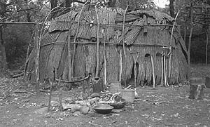
Pre1800
The Native American’s had successfully occupied Fayette County for
hundreds of years, hunting, gathering, planting in small field. Their villages
were generally along the streams and their trials followed the same
"best" pathways that had developed from centuries of successful
occupation of the land with significant ecological damage.
The Turkey River valley near Elgin was named Shin Bone Valley by the Indians. The area had been the home of many Indians. Anthropologists believe the Red Ocher people lived here before the birth of Christ, and perhaps until 500 A.D. They left the small, round burial mounds like those seen by the early settlers between Elgin and Lutra.
Next came the Hopewell Indians, who built much larger burial mounds, as these Indians buried implements and food with their dead for the afterlife. At least two large mounds in the area that can still be seen are attributed to the Hopewell Indians. The Red Ochre and Hopewell overlapped in time, but by about 600 A.D. both were gone.
Then came the Effigy Mound builders. Their burial places were small mounds, or mounds of animal shapes. Elgin is on the western edge of the Effigy Mound builders' territory. The last of them seem to have left the area about the time Columbus discovered America in 1492.
Then the Sioux, Algonquin, and many other tribes lived in the area. They recognized the burial places of previous people, and buried in the same place. Remains then of several civilizations may be found in one spot.
In 1675, when Marquette first discovered the land called Iowa, the Illini Indians inhabited the area.
1800
Iowa in the early 1800's belonged to the Indians. The Sioux warred with the Sac
and Fox, eventually catching the catching the peaceful Winnebagoes in between, after they were moved
from Wisconsin to the neutral grounds starting in about 1825. Northeastern Iowa had
been dominated by Sac/Fox settlement for many years up to this point. The general
population density had been low, at about 3-20 people per square mile. The
native
Americans of the area lived mainly by hunting and gathering natural game and plants with a
little agriculture involved. They had made a successful living for centuries.
1803
Iowa formed a portion of the American territorial
acquisitions from France, by the so-called Louisiana purchase in 1803, and was politically
identified with Louisiana until 1812, when it merged into the Missouri
Territory.
But when in 1803 the United States government obtained the state as part of the Louisiana Purchase, the Sac, Fox, and loway tribes possessed the entire territory which is now the state of Iowa.
The Fox had one of their principal villages on the banks of the Turkey River. North of the Sac and Fox nations was the hunting ground of the Sioux tribe,,who frequently invaded the Sac and Fox territory, resulting in fierce battles. Innumerable Indian arrowheads and spearheads were unearthed when the early settlers tilled the soil.
1812
The area that would be Iowa was merged into the Missouri Territory
1825
The Formation of the Neutral grounds
(sections taken from "History of Fayette County, Iowa 1878" and from
"Fitch's Fayette County History of 1910")
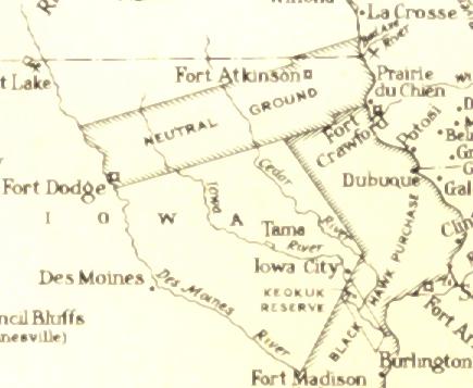
The ground seen on the map was a strip of land set
aside in 1825 at a treaty conference in Prairie du Chien, with the intend of separating
the Sioux to the north and Fox/Sac nations to the south. The Winnebagoes were
displaced starting in 1833 from Wisconsin to occupy the neutral grounds (the trail from
Dubuque to Fort Atkinson and the Fort would be constructed starting in 1840), until they
were moved out and to Minnesota by 1848, at which time the northeastern 3/5ths of the
county was opened to the "white tide." Basically the Fayette County area
was dominated by the Ioway tribes of the Oneota Indian Culture and sometime in the 1600's
by the Sac/Fox tribes until this time, as is evident by the massive burial grounds in what
is now the Elgin Valley (shinbone valley) and in the Wadena Valley. The native
American cultures of the Fayette area generally compbined both prairei and woodland
characteristice as they lived on the interface between the two natural habitats. The
cultures combined gardening or small field skills with hunting, gathering lifestyles.
The Black Hawk Wars and thus the Black Hawk "Purchase" acquired the strip
of land along the western side of the Mississippi River as noted on the map, so by 1833
the southeastern 2/5ths of what is now Fayette County was opened to white
settlement. The neutral ground's southern boundary ran across the Fayette Valley
area, with the Black Hawk Purchase to the south. On the map the left upper tip of
the "F" in Fort Crawford is about the position of the Fayette Valley. The
few white settlers in Fayette County during the early 1840's, where generally located in
log cabins along the southern boundary of the neutral grounds about 2 miles south of
Fayette. It would not be until the late 1840's that whites would settle permanently
in the Fayette Valley. From about 1849 on, there would be very rapid acceleration
of two settlements in the valley with the area of the present main street surviving
and rapidly becoming one of the several dozen prosperous pioneer villages of Fayette
County.
the Sac and Fox Nation site
Prior to June, 1833, the entire State of Iowa was in the undisputed possession of the Indians---Sacs and Foxes---while north of their territory, in what is now Minnesota, were the hunting grounds of the Sioux. Between those nations , a state of constant warfare existed. Boundary lines were unknown to the native Americans, and bloody conflicts between these hostile and war-like tribes were frequent as they made incursions upon each other's territory.
In its effort to secure peace ('more likely land, territory and power') among the tribes of the Northwest, the Government of the Untied States, represented by William Clark and Lewis Cass, negotiated a treaty on the 19th of August, 1825, at old Fort Crawford at Prairie du Chien, Wisconsin, with the Chippewas, Sacs and Foxes, Menominees, Winnebagoes, etc., in which it was stipulated and agreed that the US should run a line between the Sioux on the north, and the Sacs and Foxes on the south, commencing at the mouth of the Upper Iowa River, ascending said river to its west fork, thence up that fork to its source, thence crossing the fork of the Red Cedar River on a direct line to the second or upper fork of the Des Moines, thence in a direct line to the lower fork of the Calumet, and down the stream to the Missouri.
The Indians, however, did not very scrupulously observe this imaginary line and a "Neutral Ground" was established. In a treaty of July 15, 1830, the Sac and Fox band ceded a strip of country twenty miles wide on the south, and the Madawakanton, Wapakoota, Wahpeton and Sisiton bands of Sioux, ceded twenty miles on the north of the line of 1825, from the Mississippi River to the Des Moines.
The southern boundary of the neutral ground was located through Fayette County but "inasmuch as no line of public surveys has been closed on the south line of the neutral ground in after years, no precise locus of the boundary can be designated in reference to Government Surveys. Some years ago Andrew Hensley cut a blaze on an oak tree on Section 24, Township 93 north, Range 8 west, and this blaze would represent the southern boundary of line as of 1833."
Thus a strip of neutral territory, forty miles
wide extended from the Mississippi River west to the East fork of the Red Cedar River, was
established between these ferocious tribes, on which they were permitted to hunt and
fish in common, but were forbidden to fight. The southern boundary passed through
Fayette County on a line running about two miles north of Wadena, through the Fayette
valley, and about three miles north of Maynard. The boundary will ill defined and
basically cut across the county at a light angle from the east toward the southwest, with
about 3/5ths of the county land mass being in the neutral territory, thus the bottom
southeastern 2/5ths was legally opened to white settlers from about 1833 on, while that
area north of the line in neutral terriorty did not legally open up until the Winnebagos
would once again be displaced to Minnesota in 1848 after a 1946 treaty. Thus the
Wilcox cabin built around 1840, the first permanent cabin in the county, was built
just below the neutral territory line, two miles southwest of present Fayette.
1830
In 1830 the United States "bought" a strip of land 20 miles wide from the Sioux and another 20 miles wide from the Sac and Fox. This was called 'Neutral Ground.' Both tribes could hunt and fish in the area provided they did not interfere with each other on United States territory. The southern boundary of this Neutral Ground passed through Fayette County, going southeast across Illyria, Westfield, Center, Harlan and Fremont Townships.
1830 the Wisconsin Territory was formed, and in 1837, under the jurisdiction of that territory, Dubuque County was divided and the boundaries of Fayette County were defined. In 1836 some of the first surveying would be done in Fayette County, south of the Neutral Ground.
1832
In 1832 the U.S. government established the neutral strip of land
about forty miles
wide in northeaster Iowa with the southern border of the "neutral ground"
running through present Fayette. The Sioux were to be to the north of this strip and
the Sac and Fox to the south. And the Winnebagoes would be shortly displaced from
Wisconsin to occupy the neutral ground and a fort would be built at Fort Atkinson as an
outpost into the area under the guise of Indian protection.
The Black Hawk Purchase
The
Black Hawk War closed in August of 1832. The Sac and Fox Nation by treaty ceded to
the United States a strip of land on the west side of the Mississippi River, 50 miles
westward, from the south line of the neutral ground to the Missouri state line as viewed
on the map at the top of this page.
1833
The Winnebagoes were displaced starting in 1833 from Wisconsin to occupy the neutral grounds.
The Winnebago reserve on Neutral Ground and the first attempt at lodgment in fayette county
In a treaty with the Winnebago Indians made in 1832, the area which would include the neutral ground was ceded to that nation in exchange for Winnebago lands on the eastern side of the Mississippi. The Winnebago of Wisconsin would basically be displaced to the neutral ground and acted as a buffer between the other Indians groups. By 1935 the Winnebagoes had been gotten across the Mississippi River in large enough numbers that there was established on the Yellow River in Allamakee County, a combined farm, school and mission, which would then be removed when Fort Atkinson was built in 1840-41, also to include a combined farm, school and mission reaching into the present Auburn township of Fayette County, above the present St. Lucas. There the 2,900 Winnebagoes remained for eight years until they were removed again by "treaty" in 1848 to Minnesota.
Fayette County was actuarially opened for white settlers in four separate tracts. In 1833, the Black Hawk Purchase opened the southeastern 2/5ths. West of that, in 1837, a small additional purchase from the Indians, and in 1842 the rest of the southwestern portion was opened along with the much larger purchase embracing at least half of Iowa below the neutral grounds. In 1848, the remainder of the county, more than half, to the north and northwest which was in the neutral grounds was opened up with the displacement of the Winnebagoes to Minnesota. Officially the treaty was signed in 1846 and there had been white settlers exploring the entire county.
1834
The Iowa area, in 1834, came under the Michigan
organization.
1836
In 1836, Iowa came under the Wisconsin
organization.
From all testimony available it appeared reasonably certain that the first work done by whites in Fayette County, aside from surveys, was an attempt to build a mill near the mouth of Otter Creek (to become Elgin), which was on the Winnebago Reserve. Apparently Edson and Grant, from the valley of the Turkey River, below where Elkader now stands, went up to the mouth of Otter Creek in 1836 or 1837, built a shanty, commenced to build a dam, got out the timber for a mill frame and hauled it to the spot, and made excavations. It was stated that when the work had progressed thus far, they discovered it was on the reserve and left, when the Indians burnt their shanty, set fire to the timber and destroyed the dam. Other accounts state that when the Indians discovered that white men were trespassing on their domain, they made complaint to their agent at the old Winnebago Mission in the northern part of Clayton County and the agent notified Edson and Grant to leave forthwith. Since Edson was a surveyor and Grant a farmer, it was reasonable to conclude that they attempted to locate the mill with full knowledge they were trespassing and hoped to conciliate the Winnebago owners but failed to accomplish that purpose and were compelled to abandon their enterprise and improvements. Samuel Conner stated that when he came to the county in 1848, a large portion of the timber remained unburned and was used by the first settlers as fuel for their lime kilns, and that most of the evidence of the mill race had been obliterated. This was unquestionably the first attempt of the whites to make lodgment in Fayette County.
1837
The Brush Creek and Taylorville area of SE Fayette County, Iowa was
surveyed shortly after 1836 after the land taken from the native American’s by
the U.S. government in the Blackhawk War and Blackhawk "Treaty." White
settlers began immediately "probing" Native lands to claim as their
own. Westfield Township's southern border was surveyed in 1837,
during the first survey in the county.
1838
The map above of the Black Hawk "Exploitation" will show the lines of neutral ground and the Black Hawk territory taken. At this time there were only four townships in Fayette County surveyed and open to settlement, Putnam, Fairfield, Smithfield and Scott, which included the area of Brush Creek (Arlington) and Taylorsville.
1839
Trappers and traders knew the area on the
east side of the Turkey River Valley in the present day Elgin area as "Sac Bottom" (now Sec. 10 and 31). This area
was an immense Indian burial ground with graves so shallow that the bones of those
interred could be seen protruding from the ground.
1840
The trail from Dubuque to Fort Atkinson and the Fort in the Neutral Grounds would be constructed starting in 1840. This trail, now called the "Old Mission Trail," would cut diagonally across Fayette County from the SE corner to the NW corner, passing through Brush Creek/Arlington across the Corn Hill area, and just south of Fayette near the Wilcox Cabin, and then swing out to the west of Westfield/Fayette by a couple of miles before going just to the east of Randalia and on north. Remember, none of these settlements were present then. Only Native Americans lived in the area, while a few white trappers, settlers and others were probing and exploring for possible "taking over" of resources and land.
Fayette County was actuarially opened for white settlers in four separate tracts. In 1833, the Black Hawk Purchase opened the southeastern 2/5ths. West of that, in 1837, a small additional purchase from the Indians, and in 1842 the rest of the southwestern portion was opened along with the much larger purchase embracing at least half of Iowa below the neutral grounds. In 1848, the remainder of the county, more than half, to the north and northwest which was in the neutral grounds was opened up with the displacement of the Winnebagoes to Minnesota. Officially the treaty was signed in 1846 and there had been white settlers exploring the entire county.
EARLY WHITE SETTLERS ARRIVED IN FAYETTE COUNTY, THE INDIANS WOULD BE DISPLACED AND TWO VILLAGES WOULD BE ESTABLISHED IN THE FAYETTE VALLEY
Links:
Living History Farms
near Des Monies, Iowa
Elgin Then and Now 1848-1988
The History of
Iowa, by Dorothy Schweider, ISU
IOWAY NATION
the Sac and Fox Nation site
Winnebagoes
SITE CONTENT USE STATEMENT---The material on the Iowaz pages is dedicated the Ancestors of the Fayette Valley and Area. The Fayette and Westfield Timeline is a collection of notes from various sources with a significant amount of material from personal evaluation and background, including personal speculation and opinions. Donation of materials has occurred but credits are generally not listed as the main purpose has been the personal piecing together of Fayette history, thus much of the material has been re-written. I want to make the info and pics available for genealogy and historical interests in a timely fashion so much of the material is being uploaded in rough draft form and then refreshed as editing occurs. All pages are very large and will take a long time to load. If they "time-out" try using the refresh button, as your browser will basically restart where it left off. An attempt has been made to include ALL of the information with names so that those with genealogical interests might associate with the the history and lifestyles of their ancestors from the Valley. Nearly every pic in the site has been taken with a Sony FD91 digital camera. There will be hundreds of pics regarding the Fayette area available on albums uploaded to Photopoint.com. You will find links into Photopoint albums sprinkled thoughout this site. Learn to use Photopoint as there are many pics of interest to you there. Any reproduction of this site or it's contents for other than personal non-profit genealogy and history use requires express written consent.
Site page links:
[] Fayette
History Index [] Iowa
Z Sitemap [] Email Iowaz
[]
|
|


Sign
our Guest book
IOWAZ
SITEMAP
Any reproduction of this site or it's contents requires express written consent.
