Site hosted by Angelfire.com: Build your free website today!
<\/body><\/html>') newWindow.resizeBy(picWidth-newWindow.document.body.clientWidth,picHeight-newWindow.document.body.clientHeight) newWindow.focus() } //-->
Logan Pass Summit, Mountain Goat, Bear Grass.
HUGEfloods.com Home Page Not much time? ... Click here for a quick Ice Age Floods summary Ice Age Floods Feature of the month For many years one man understood the clues but no one would listen Glacial Lake Missoula Channeled Scablands of Eastern Washington Temporary Lake Lewis Columbia Gorge Explore the variety of features created by the Ice Age Floods Columbia River Basalt Group The Pleistocene Grand Coulee Dam and the Columbia Basin Irrigation Project Washington Wines Ice Age Floods Institute


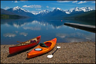
Lake McDonald, Glacier National Park.
Lake McDonald


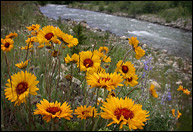
Glacier National Park wildflowers.

Tour the Ice Age Floods Region

Tour Stop A - Logan Pass and Hidden Lake Overlook

I'll try to have suggested tour completed by the end of March 2012
(Will list 35 sites). ... 9 Feb 12 ... Tom

Use caution visiting flood features listed (especially with pets and children) and be aware of the many hazards related to driving and hiking in Montana, Idaho, Washington and Oregon!

Sites listed here are a few of the locations that I (Tom) have found interesting. Just trying to list a few suggested features (with variety in mind along a basic route rather than thousands of miles of driving) along the Ice Age Floods National Geologic Trail.


Hidden Lake overlook in Glacier National Park.

Hidden Lake Overlook- is not in the Flood Region ... but ... Is a perfect starting point for an Ice Age Floods tour. Glacier National Park visitors will find many excellent interpretive displays that describe the most recent Ice Age. Check "Going-to-the-Sun Road" and Hidden Lake trail conditions before traveling to this location. Hiking to the overlook may involve hiking on steep snow or ice.


1. Lake Columbia Strandlines 8. Moses Coulee 14. Sentinel Gap 20. Streamlined Palouse Hills
2. Steamboat Rock State Park 9. West Bar Giant Current Ripples 15. Mattawa Bar and Erratics 21. Devils Canyon
3. Lake Columbia Varves 10. Potholes Coulee 16. White Bluffs (Hanford Reach) 22. Badger Mountain
4. Dry Falls State Park 11. Frenchman Coulee 17. Drumheller Channels 23. Chandler Narrows
5. Deep Lake Potholes 12. Ginkgo State Park 18. Washtucna Coulee 24. Badger Canyon
6. Lake Lenore Caves 13. Wanapum Clastic Dikes 19. Palouse Falls State Park 25. Wallula Gap
7. Ephrata Fan

A. Logan Pass/Hidden Lake B. National Bison Range C. Camas Prairie Ripples D. Rainbow (Dog) Lake
E. Eddy Narrows - Sandpoint, ID

F. Lake Condon G. Horsethief Butte/The Dalles H. Multnomah Falls Area I. Willamette Meteorite
J. Bellevue Erratic

Glacier National Park National Bison Range Mission Valley Overlook Camas Prairie Giant Current Ripples Rainbow (Dog) Lake Eddy Narrows and Sandpoint, Idaho Lake Condon Horsethief Butte and The Dalles Multnomah Falls Area Willamette Meteroite Trail The Bellevue Erratic Wallula Gap Chandler Narrows Badger Coulee (Canyon) Badger Mountain Devils Canyon Palouse Falls State Park Streamlined Palouse Hills Washtucna Coulee White Bluffs (Hanford Reach National Monument) Drumheller Channels Mattawa Bar and Erratics Sentinel Gap Ginkgo State Park Frenchman Coulee & Echo Basin Potholes Coulee West Bar Giant Current Ripples Moses Coulee Ephrata Fan Deep Lake Potholes Glacial Lake Columbia Varves Steamboat Rock State Park Glacial Lake Columbia


All photos by Tom Foster unless otherwise noted.

HOME Space CONTACT Space SITE MAP IAFI Space LINKS Space © 2008

Ellensburg
Lake Missoula
Lake Lewis
Ice Age Blog
Ice Age Express
Feature of the Month
The Mystery
25 Features
Channeled Scablands
Ice Age Floods Videos
Columbia Gorge
Feature Types
Columbia River Basalt
The Pleistocene
Grand Coulee Project
Washington Wine
Ice Age Floods Inst.
The Bonneville Flood