
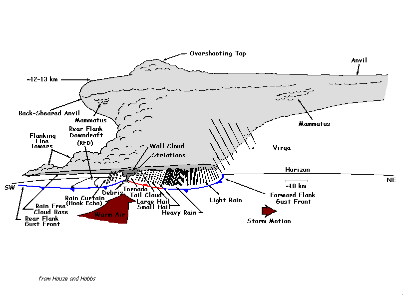
Meteorological TermsAdvection: The horizontal transport of an airmass or atmospheric property by horizontal wind. Examples are advection of warmer air, colder air, moistening air, drier air, vorticity, etc. AFD: Area Forecast Discussion. AFD's are a technical discussion for the upcoming forecast period... and are issued by local NWS Offices several times per day. They are meant for office-to-office coordination, and are also widely used by many meteorologically advanced individuals. Air Mass Thunderstorm (popcorn storm): A thunderstorm that is not associated with fronts, or other large scale storm systems. They are reliant on sunshine for formation, can develop quickly, and usually last for a short time. Air mass thunderstorms are most likely from the mid afternoon through the mid evening... dissipating rapidly with sunset... on warm and moist spring and summer days. These storms are usually not severe, but occasionally are. (an example of a very severe air mass tstm was on June 20, 1998.) When they do reach severe limits, the most likely threat is damaging wind and possibly large hail. Remember, torrential rain, deadly lightning, gusty winds, and small hail can occur with any thunderstorm. ALY: The ID for the Albany, New York, National Weather Service Forecast Office (NWSFO). This office covers much of eastern New York State, southern Vermont, far western Massachusetts, and far northwest Connecticut. BGM: The ID for the Binghamton, New York, National Weather Service Forecast Office (NWSFO). This office covers central New York State and northeast Pennsylvania. KBGM, or just BGM, is also the ID for the Binghamton Regional Airport. Bow Echo: A line of thunderstorms (usually severe) which takes on a 'bow-shaped' look on a radar screen, seen on radar as an outward bulge in the line, toward the direction of movement. Damaging thunderstorm winds are possible anywhere along the line, however are most likely at the apex (usually center) of the bow echo, many times producing a swath of thunderstorm damage. Fairly often a gustnado will develop along the leading edge, but they are typically short-lived, with the main threat being thunderstorm winds. As a bow echo matures in its life, sometimes thunderstorm rotation may evolve at the northern and/or southern ends of the bow echo, thus creating potential for a brief tornado. Click here for an example radar image of an intense bow echo. This particular one would be considered a large bow echo. Frequently they are much smaller. BUF: The ID for the Buffalo, New York, National Weather Service Forecast Office (NWSFO). This office covers southwest and western New York State. KBUF, or just BUF, is also the ID for the Buffalo International Airport. Cap: Technically, any location above the ground where an air parcel would not be able to continue to rise by itself due to the parcel of rising air being cooler than the air it's rising into. Thus... a cap does not necessarily have to have an inversion present; in other words, a rise in atmospheric temperature with height is not necessary for a cap to exist. However, there often is a "pocket" (or layer) of warmer air (relative to the air below and above it) above the ground. A cap can typically be found somewhere between 2,000 and 15,000 feet above sea level, though rarely would extend through that entire height. The exact location of a cap within the above given height range changes with geographical location and with each event. A cap acts to either delay or completely inhibit the development of thunderstorms. Some caps are able to be broken though, and others can keep an entire day thunderstorm-free (even if significant instability is available). When a cap breaks, or dissipates, however, thunderstorm development (often severe) can result very rapidly. Explanation: When air parcels rise, they must constantly be warmer than the surrounding air in order to continue to rise on their own. Normally this is the case, but when a cap exists, the parcels rise into warmer air, making the parcel cooler than the surrounding air. Thus, they are not able to rise further and develop into thunderstorms. If a parcel/developing cumulus cloud were to break through the cap, it would shoot upward very quickly as it entered the cooler air again, often developing into a severe thunderstorm. CAPE: Acronym for Convective Available Potential Energy. CAPE indicates the amount of energy an air parcel would have if it were lifted. In turn, it shows (and is directly associated with) the potential strength of updrafts within convective clouds. The higher the number, the more energy available for convective development. In general, CAPE values below 1,000 J/kg (joules per kilogram) are usually considered fairly low... while values at or above 4,000-5,000 J/kg would be very high. As is true with all severe weather indicators though, there is no "magic" value where severe convection becomes likely. Other atmospheric conditions play a significant role in the formation of severe weather, and must all be evaluated to determine severe weather potential. If favorable dynamics or vertical wind profiles are present, and CAPE is low, severe weather can and does still occur. Isolated supercell thunderstorms and tornadoes can and do occur with values below 1,000 J/kg if other favorable conditions are present. CLE: The ID for the Cleveland, Ohio, National Weather Service Forecast Office (NWSFO). This office covers much of northern Ohio, and far northwest Pennsylvania. KCLE, or just CLE, is also the ID for the Cleveland International Airport. Condensation Funnel: A funnel shaped cloud associated with a rotating column of air, which is associated with convection. This is what makes a tornado visible. It forms from condensed water droplets, as all clouds do. Sometimes parts, or even all, of the condensation funnel will not be visible... thus making the tornado invisible. This does not affect the strength of a tornado one way or another. The only way to identify if a tornado is on the ground without any condensation funnel, is to look for rotating debris beneath the thunderstorm. Convection: In meteorology, the vertical transport of moisture and heat by updrafts and downdrafts. Cumulus clouds, showers, and thunderstorms are all forms of convection. While the term is most widely used referring to thunderstorms, it is only one type of convection. Showers that don't become thunderstorms, and all cumulus clouds, are other forms of visible (moist) convection. Invisible (or dry) convection also occurs on many days without moist convection, in which case we would never see the visible phase. Dry convection is the phase before a cumulus cloud forms, as an invisible air parcel rises but before the water vapor condenses into liquid water droplets to make the cloud visible. In meteorology, convection is basically the opposite of advection. Convection is a major factor in our atmosphere and weather, and is a term frequently used by forecasters. The opposite of convection is stratiform. Convective Outlook(s): Issued by the SPC several times daily, indicating where the threat of thunderstorms and severe thunderstorms, if any, will be in the continental United States for the next 72 hours. These outlooks are aimed more toward forecasters, and individuals who are advanced in the meteorology field, rather than the general public... as they are technical guidance outlines/discussions. The Day-1 Outlook is issued/updated 5 times a day, valid until the next morning. The Day-2 Outlook is issued twice per day, valid for the next day. Finally, the Day-3 Outlook is issued once per day, valid for the third day into the future from the point of issuance. Four risks are used to describe the coverage (and often severity) of convective activity in the Day-1 and Day-2 outlooks; See "General Thunderstorms", "Slight Risk", "Moderate Risk", and "High Risk" for details on each category. Slight risk, Moderate risk, and High risk are used to describe the coverage of severe thunderstorms... not necessarily the intensity of them (however it usually reflects it). Convective Temperature: The temperature that air at the surface must be heated to for convection to begin freely (ie, resulting from heating from the sun only). The convective temperature does not necessarily apply to convection that forms from forcing along fronts or other means. Thus... convection can easily occur before or after the convective temperature is reached, if an air parcel is forced upward from another source. The convective temperature is found by examining a sounding, and is useful only if atmospheric conditions throughout the day do not significantly change. Often, convective temperatures can be quite useful for predicting when convection will begin on summer days, since sunshine can be what initiates convection on numerous summer days. CTP: The ID for the State College, Pennsylvania, National Weather Service Forecast Office (NWSFO). This office covers a large section of Pennsylvania... including all of central PA, from the Allegheny mountains to the Susquehanna Valley. CWA: County Warning Area. Each National Weather Service office has an area of responsibility which they issue forecasts and warnings for, called the County Warning Area. Debris Cloud: A cloud of dust and/or debris, seen at and/or just above the ground, associated with most tornadoes. A debris cloud confirms the presence of a tornado, even if a condensation funnel is not present. The term debris cloud(s) (or just simply 'debris') is also sometimes used to describe the high clouds blown off the tops of thunderstorms. These clouds, sometimes also called 'blow-off', can spread hundreds or thousands of miles downwind from the actual location of the parent thunderstorms. Derecho: A widespread line of intense severe thunderstorms that produce significant damage to property and pose a serious threat life, primarily by thunderstorm winds. Major derechos can down many thousands of trees, and damage and destroy hundreds and thousands of buildings along its path. Some people use the term 'derecho' to loosely, and a number of events are incorrectly classified as a derecho. To be classified as a derecho, all of the following criteria must be met: Dew Point: The dew point temperature is the temperature to which the air must be cooled to reach saturation (assuming air pressure & moisture remain the same)... and thus indicates when dew, frost, fog, and clouds form. The dew point is a direct measure of the amount of moisture present in the air, and directly affects how you feel... or in other words... measures the amount of humidity in the air. Remember, the temperature never drops below its dew point, but can be equal to it. A detailed discussion and examples of dew point verses relative humidity has been made for this website. That page is filled with all the facts about the subject, and clears up much of the confusion that some people have when it comes to dew point and relative humidity. Downburst (a.k.a., thunderstorm winds): A sudden damaging wind that accompanies many severe thunderstorms... and on rare occasions, showers. A downburst is simply the damaging form of a downdraft. Wind speeds with a downburst can approach 160 mph on some instances, however are more frequently less than 100 mph. The minimum wind speed would be considered by most to be 58 mph, which is the lower limit for a severe thunderstorm. Either way, damage is done. Damage can resemble that of a strong tornado, and downburst damage is often incorrectly blamed on tornadoes. Downbursts can be divided further into two main types; See Microburst and Macroburst}. Downdraft: A sinking column of air within and underneath a shower or thunderstorm. Every thunderstorm contains a downdraft (which is not necessarily damaging) However, a downburst (which is damaging) only occurs in severe thunderstorms. Thus, a downdraft may not always be a downburst, but a downburst is always a downdraft. An updraft is the opposite of a downdraft. Energy Helicity Index (EHI): The EHI takes into account both vertical shear and instability, and is computed directly from storm relative helicity and CAPE values. So, a high EHI indicates either a strongly sheared environment, an unstable atmosphere, or both. It is a pretty simple value to figure out if you have the helicity and CAPE already at hand. To find EHI, multiply CAPE and helicity, and divide that number by 160,000. This answer will be your EHI. For example, a CAPE of 2000 and a helicity of 200 gives an EHI of 2.5. In general, EHI numbers of 1 or greater indicate an increasing risk of severe weather. Values greater than 5 are extreme, and may indicate the possibility of intense supercell thunderstorms and violent tornadoes if other favorable conditions are present. As is true with all severe weather indicators though, there is no "magic" value where severe convection becomes likely. Other atmospheric conditions play a significant role in the formation of severe weather, and must all be evaluated to determine severe weather potential. Flash Flood: A flooding condition in which the onset occurrs relatively rapidly... and only lasts for a short period of time, often 6 hours or less. They are most commonly caused by local heavy rains associated with convection. Most often, flash floods occur on streams and creeks rather than rivers. However, ice jam breaks may cause a flash flood on a larger river. Significant flash floods can be extremely destructive, and deadly, primarily due to the sudden unleash of torrents of water. In some regions, a flash flood may begin in literally just a few minutes, even with a previously dry creek bed. Raging waters can suddenly infiltrate an area, wiping away mostly everything in its path. Other flash floods are not quite as violent, but can also occur very quickly. Some flash floods can easily carry away huge boulders, any car or large truck, and houses... and rip apart roads. Thus, flash floods need to be treated with the utmost respect. Remember, flash flooding is the #1 killer in the United States. Flash floods should not be confused with a river flood, or sometimes called just a flood. Funnel Cloud: A condensation funnel associated with a rotating column of air, which is NOT in contact with the ground, extending from the base of a towering cumulus or cumulonimbus cloud... almost always a thunderstorm. Since a funnel cloud by definition is not touching the ground, a funnel cloud is NOT a tornado (despite the media using the terms interchangeably). Only when the rotating column of air reaches the ground is it a tornado. In addition, the entire condensation funnel may not necessarily be visible if it touches down and becomes a tornado. Sometimes the upper half of the funnel will only be visible by a condensation funnel, while the rotating column of air is still in contact with the ground (although not visible) and thus it is still a tornado. Then, the only way to tell if a tornado is on the ground is by dirt, dust, and flying debris (see debris cloud). Note: All funnel clouds do not touch down and become tornadoes. Out of the thousands of funnel clouds each year, less than 1,000 touch down and become tornadoes. General Thunderstorms: Term used in the daily Convective Outlook issued by the SPC. The area outlined as "general thunderstorms" (abbreviated 'gen tstms') shows where most or all thunderstorms are forecast to remain below severe thunderstorm levels. On some occasions, however, a very isolated thunderstorm or two will become severe even within the general thunderstorm area. This does NOT necessarily mean the forecast was wrong. A higher risk can't be used for every single severe thunderstorm that occurs, otherwise many areas would frequently be in slight risks, while almost nobody would see severe weather. Bottom line is this: while most of the time there will be no severe weather in general thunderstorm areas, very isolated severe thunderstorms will occasionally occur. See "Slight Risk", "Moderate Risk", and "High Risk" for additional outlines used in convective outlooks. Gust Front: The leading edge of gusty surface winds (a short distance ahead of thunderstorms) produced by shower or thunderstorm downdrafts. A gust front acts in many ways like a small scale cold front... as gust fronts usually are associated with a sudden wind shift, gusts of wind, and a rapid drop in surface temperature. Gust fronts separate the thunderstorm/rain cooled air from the air (usually warmer) outside of the thunderstorm. In some cases, especially with lines of thunderstorms, damaging wind gusts will occur along the gust front just prior to the actual thunderstorm, and there may be little or no rain falling at the time. Visually, there may be a shelf cloud or roll cloud associated with the gust front. Most people agree that a gust front is basically the same as an outflow boundary, with only minor differences. Generally, the term gust front is used when the convection that formed it is still present, and the gust front is still relatively close to the parent convection. It is called an outflow boundary when either the gust front gets too far ahead from the parent convection, or the convection that formed the gust front dissipates... yet the boundary still remains. Gustnado: A small, short-lived, relatively weak (usually winds less than 110 mph) "tornado". They usually form along the leading edge of the thunderstorm gust front, or downburst. They are NOT directly associated with rotation within the parent thunderstorm, and thus do not form from a funnel cloud working its way down toward the ground. Instead, they form from a swirl at the ground and extend upward. Thus, by definition, a gustnado is not really a true tornado... although they are often refered to as one by many trained people, and this is generally accepted among the meteorological world. Gustnado circulations may never reach the cloud base, but in some cases may reach the cloud base... making it difficult for even experienced Spotters or Chasers to distinguish the difference between it and a true tornado. Visually, there is usually no condensation funnel present... often making their presence seen only by flying dust and debris. Since gustnadoes are not associated with storm scale rotation (a mesocyclone), as noted above, they are basically impossible to warn for specifically, and they tend to occur randomly with many severe thunderstorms. Therefore, tornado warnings are usually not able to be issued, and a severe thunderstorm warning may be your only warning. Gustnado damage, which is most commonly of F0 or F1 intensity, is usually embedded within a larger area of downburst damage. Helicity: Helicity values are used to show where there will be enough rotation/shear for thunderstorms to develop mesocyclones (i.e., the rotating part of a thunderstorm). Helicity values are obtained from looking at the lowest several thousand feet of the atmosphere (mostly commonly from surface up through 3 km) in a vertical wind profile. Further, it is measured relative to thunderstorm motion, and is called Storm Relative Helicity. Where helicity does not exist, thunderstorms grow completely vertically, and the falling precipitation soon cuts-off (or "chokes") the updraft... killing the storm. Helicity is needed to maintain the organized structure of thunderstorms, allowing them to not only develop past severe limits but also sustain themselves for an extended period of time. There is no set value where mesocyclones become imminent, but usually widespread values of 150 or more favor the development of mesocyclones (and the resulting possible tornadoes). However, with other conditions favorable, values of less than that are enough to support isolated mesocyclone development. The higher the Storm Relative Helicity (SRH), the more intense and widespread supercell thunderstorm mesocyclones are likely to be. In extreme cases, values may reach or even exceed 600. Helicity and CAPE are frequently used in conjunction with each other to determine thunderstorm location and intensity, and each of them put into an equation make the Energy Helicity Index (EHI). High Risk: Term used in the daily Convective Outlook issued by the SPC. Within the region outlined by a high risk, the following is forecast to occur: 20 or more tornadoes (with at least 2 being of F3 intensity or higher), and/or an exceptionally widespread line of very intense severe thunderstorms causing over 50 reports of wind damage or severe gusts, including numerous 80+ mph reports/damage. Large hail will also often occur in high risk areas, sometimes very large hail. A high risk is very rare... and implies that widespread severe, and often extreme, weather is expected. Significant tornado outbreaks and major derecho events are prime candidates for a high risk. A PDS statement is virtually always issued on high risk days. Inversion: Refers to an increase in temperature with height through a certain layer in the atmosphere. There are several different types of inversions. A 'stratospheric inversion' is usually always there... but that is located tens of thousands of feet aloft and you won't hear the term talked about very often. Affecting us at the ground, and occurring with great frequency, is the 'nocturnal inversion'... which typically is present by early morning on over 75% of all days. Hence its name, nocturnal inversions (sometimes called radiation inversions) obviously occur at night... specifically during mainly clear and calm nights. On these types of nights... colder air sinks down into the valleys/lowest spots available, while warm air from the daytime rises, with a rise in temperature as one would go up to the ridgetops and just above. Nocturnal inversions usually dissipate quickly after sunrise during morning. Another type of common inversion is the 'subsidence inversion', usually the result of an area of high pressure. Subsidence inversions can be very strong with a sharp rise in temperature. The location of the base of the inversion can vary quite a bit... being just a few thousand feet above the surface on some occasions, to over 15,000 feet aloft at other times. Subsidence inversions are usually 2,000 to 3,000 feet thick. They form from downward moving/sinking air, usually in association with a high pressure system, and thus covering a relatively large region. As a layer of air (again, 2-3Kft thick usually) moves downward, it compresses (i.e., the layer of air gets thinner). Downward moving, compressed air heats up... and thus creates the inversion. Another type of inversion is a 'frontal inversion', which occur with many fronts. They are usually most significant with warm fronts, as warm air "overruns" the colder air at the surface. The final type of inversion is called a 'marine inversion'. These occur along the coastline of oceans, and the shores of larger lakes, when cool ocean (or lake) waters cool a warm airmass at the surface. KI: The K Index is one of many instability indicators... and shows the potential the atmosphere has to generate air mass thunderstorms, and is also used for forecasting flash flood potential. The higher the number, the better chance for air mass thunderstorms to form (with other favorable conditions). The following is used to determine the KI: 850mb-500mb lapse rate, plus 850mb dew point, minus 700mb dew point depression. A KI of below 15-20 show a stable airmass where air-mass thunderstorms don't occur. KI's in the mid and upper 20s show isolated to scattered air-mass thunderstorms are possible. KI's above 30 usually indicate a rather good liklihood of widespread, scattered to numerous air-mass thunderstorms. KI values can reach or exceed 40 sometimes, but are not as common as values in the 30s which are considered substantially high. As is true with all severe weather indicators though, there is no "magic" value where convection becomes likely. Other atmospheric conditions play a significant role in the formation of thunderstorms and severe weather, and must all be evaluated to determine convective potential. In the case of the K Index... it can sometimes be misleading. For example, since the KI takes into account mid level moisture, if very dry air aloft is present then the KI would be fairly low, yet air mass thunderstorms can still occur if the low levels are substantially moist. LEWP: Acronym for Line Echo Wave Pattern. A LEWP is a line of thunderstorms which has a wavy-shaped bulge in it... partially resembling a bow echo. The main difference in appearance (on radar) between a LEWP and a bow echo is that a LEWP contains not only a segment of the line bowed outward, but also inward. It may appear as somewhat of an "S" on a radar screen... though usually not as dramatically curved as the letter "S". Damaging thunderstorm wind gusts are the main threat with a LEWP, but tornadoes (especially gustnadoes) have been known to occur. LI: Stands for Lifted Index. The lifted index is one of the numerous measures of air stability, measured in degrees Celsius (C). It is calculated from the difference between the temperature of a rising air parcel and the surrounding air temperature at a specific level above the ground. By far, the most common level this temperature difference is taken at is at the 500mb level, which is located around 18,000 feet above sea level. For example, say you had a 500mb air temperature of 0 degrees celsius (0C)... and the temperature of a rising air parcel by the time it reached 500mb was 6C. This would give a lifted index of -6C, since the parcel temp is 6 degrees warmer than the surrounding air temp. If the parcel temp was 6 degrees cooler than the surrounding air temp... the lifted index would be +6C. Of note, the LI can be taken at any level other than the 500mb level, using the same idea as given above. However, unless it is otherwise mentioned, forecasters are virtually always refering to the temp difference at the 500mb level. The lower the LI number, the more unstable the atmosphere is. Generally, LI's below zero (negative numbers) are needed for thunderstorm development. Above +1 or +2 represents a more stable airmass, and thunderstorms are not likely. Below -4, widespread thunderstorms are possible, along with severe weather. As is true with all severe weather indicators though, there is no "magic" value where severe convection becomes likely. Other atmospheric conditions play a significant role in the formation of severe weather, and must all be evaluated to determine severe weather potential. LL: Abbreviation for Low Level. When ended with another meteorologically used term... this refers to the lower part of the atmosphere. Common examples include low level moisture and Low Level Jet (LLJ)... but multiple other words can be used after the prefix 'Low Level' to complete a meteorological phrase. LSR: Stands for Local Storm Report. These are issued by local NWS offices to give a brief summary of severe weather that just occurred in their forecast/warning area (known as a CWA). Significant/high wind gusts, large hail, tornadoes, wind damage, flooding, or any other significant weather may be found in an LSR... along with the time and place of occurrence. These are PRELIMINARY reports, and much of the time there is more damage that occurred that just simply isn't on the LSR, usually because it was not reported to the NWS. Thus, do not consider an LSR to be a full report of all the damage from a storm... but rather an outline. LWX: The ID for the Sterling, Virginia, National Weather Service Forecast Office (NWSFO). This office covers much of Maryland, northern Virginia, and far eastern West Virginia. Macroburst: A damaging downburst wind produced from a severe thunderstorm (or on rare occasions a shower), that covers an area more than 2.5 miles wide, usually lasting for quite a few minutes, sometimes up to half an hour or so. Macroburts can cause significant damage over a relatively large area, compared to microbursts. MCC: See Mesoscale Convective Complex. MCS: See Mesoscale Convective System. Mesocyclone: A rotating updraft which persists for an extended period of time, containing strong rotation and extending through a fairly deep vertical layer within a convective cloud (almost always a thunderstorm). A mesocyclone is usually a few miles in diameter, and is where a tornado (which is much smaller than the mesocyclone itself) may develop from. If used correctly, a mesocyclone is a radar term indicating specified rotational criteria... and NOT something that is visual. However the presence of a something visual, such as a wall cloud, may indicate the presence of a mesocyclone. Mesoscale: Used to describe weather events with sizes of less than synoptic scale events. Hence their names, MCC's and MCS's are mesoscale events. Mesoscale events include some squall lines, bow echoes, derechoes... and events that cover generally anywhere from a few miles to a few hundred miles. Mesoscale Convective Complex (MCC): A large area of thunderstorms (larger than an MCS), usually round or oval shaped, that contains cloud top temperatures of -32C or less across an area at least about the size of Ohio state... and cloud top temps of -52C or less over an area about half that size. This criteria must be met for at least 6 hours. MCC's normally form in the afternoon or evening, typically reaching their peak intensity at night. At this time, flooding becomes the main threat. Severe weather (damaging wind, large hail, tornadoes) may occur at any time... but is most likely during the daylight hours. Mesoscale Convective System (MCS): An organized area of thunderstorms, on a scale larger than individual thunderstorms. They persist for at least several hours, and can be linear or somewhat round in shape. Squall lines, most bow echoes, and derechoes are a few examples. MCS's are used to describe thunderstorm clusters that do not meet the criteria of an MCC. Basically any organized area of thunderstorms can be termed an MCS. Other than that, and the complex lasting for at least several hours, there is really no specific criteria to be met. Microburst: A damaging downburst wind on or near the ground produced from a severe thunderstorm (or on rare occasions a shower), that covers an area less than 2.5 miles wide. Microbursts last for less than 5 minutes usually, but occasonally last longer. Typically, microbursts are the strongest type of downburst wind (but not to discount a macroburst), and are capable of immense destruction with peak winds reaching anywhere from 60 to 160 mph in seconds. Microbursts are a significant hazard to aviation... and have caused multiple deadly plane crashes among our Nation's major airports. Wind speeds can change dramatically from one side of an airport to the other. Microburst winds are also a significant hazard to everyday life on the ground... capable of destroying buildings, moving cars and trucks, and uprooting/snapping many trees of any size. They should be treated no differently than tornadoes. Moderate Risk: Term used in the daily Convective Outlook issued by the SPC. Within the region outlined by a moderate risk, the following is forecast to occur: 30 or more reports of hail 1" or larger, and/or 30 or more convective wind damage or severe wind gust (58+ mph) reports, and/or 6-19 tornadoes. NCEP: Stands for National Centers for Environmental Prediction. NCEP is a branch of the NWS, which belongs to NOAA... within the United States Department of Commerce. NCEP, with its Headquarters located in Camp Springs, Maryland, has 9 specialized centers. Some of the more common ones include the Hydrometeorological Prediction Center (HPC), Storm Prediction Center (SPC), and Tropical Prediction Center/National Hurricane Center (TPC/NHC). NCFR: Narrow Cold Frontal Rainband. NCFR's are a cold season convective event, which may or may not contain lightning. On radar, they are seen as a very narrow line of convection along a cold front... which may or may not be embedded within a larger area of stratiform precipitation. NCFR's are known for producing sudden strong winds with their passage. Sometimes, if atmospheric conditions are favorable, the wind gusts can become damaging to trees and structures. Gustnadoes have also been known to occur along the leading edge of some NCFR's. Heavy, but brief, rain is also a common characteristic of an NCFR. For additional information and examples of NCFR's... see our dedicated page about cold season severe weather. NHC: Stands for National Hurricane Center... located in Miami, Florida. NHC is also interchangeably called TPC (Tropical Prediction Center). NHC/TPC is government agency, within NOAA, and specializes in the forecasting and warning of all tropical weather systems across the Atlantic Ocean, Caribbean Sea, Gulf of Mexico, and the Eastern Pacific Ocean. NOAA: Stands for National Oceanic and Atmospheric Administration. NOAA is an agency within the U.S. Department of Commerce. There are numerous branches within NOAA, including the National Weather Service (NWS). NOAA Weather Radio (NWR): NOAA Weather Radio, or NWR, is a continuous broadcast of weather information... 24 hours a day all year long. Broadcasts originate from your local NWS Office. Immediate broadcast of life-saving severe weather watches and warnings will be received. When severe weather is not present... 7 day forecasts, hourly weather conditions from around the region, marine forecasts, and other information will be available. Prices for these radios range from as low as $20 to more than $50 (depending on the model/features), and can be purchased from most electronic stores and catalogs. This price is small, since it may one day save your life. NWR: See NOAA Weather Radio. NWS: Stands for National Weather Service. The NWS is a branch of NOAA, which is in turn an agency within the United States Department of Commerce. It has been universally agreed that the NWS will be the ONLY people to officially issue weather watches, warnings, advisories, statements, etc. The NWS is comprised of various different offices... including over 120 local weather Forecast Offices, 13 regional River Forecast Centers, and the National Centers for Environmental Prediction (NCEP)... among others. NWSFO: National Weather Service Forecast Office. There are over 120 local Forecast Offices across all 50 of the United States. OKX: The ID for the Upton, New York, National Weather Service Forecast Office (NWSFO). This office covers southeast New York including Long Island (where office is located), southern Connecticut, and far northeast New Jersey. Outflow Boundary: An outward flow of air from a shower or thunderstorm, separating the rain cooled air from the surrounding air. They result from the downdrafts of a convective cloud (usually a thunderstorm). Outflow boundaries are similar in some ways to a cold front, in that their passage includes a sudden windshift and temperature drop. Outflow boundaries can travel hundreds of miles from their point of origin, and persist for more than a day... even when the thunderstorms that created them dissipate. They also make a good trigger for additional shower and thunderstorm development hours later or even the next day. An outflow boundary and gust front are basically the same thing for all intensive purposes, just a different way of saying it. Generally, the term outflow boundary is used when the convection that formed it has already dissipated, or the boundary has gotton too far ahead from the parent convection. It is usually called a gust front when the convection that caused the boundary still remains, and the boundary is still relatively close to the parent convection. Thus, a gust front would come before an outflow boundary... and the gust front is only around for the length of the thunderstorm(s), while the outflow boundary may persist well after convection dissipates. PBZ: The ID for the Pittsburgh, Pennsylvania, National Weather Service Forecast Office (NWSFO). This office covers east-central Ohio, much of western Pennsylvania, northern West Virginia, and Garrett county Maryland. PDS: Stands for Particularly Dangerous Situation. This is an area of enhanced wording in SPC text, which is used on high risk days, and occasionally moderate risk days. A full PDS severe weather outlook type statement is also issued on high risk days. It implies that the threat of severe thunderstorms, and usually tornadoes, is very good... with a significant outbreak of severe weather expected. These statements are very rarely used. Thus, if one is issued for your area, take it very seriously! PHI: The ID for the Philadelphia PA/Mount Holly NJ, New Jersey, National Weather Service Forecast Office (NWSFO). This office covers most of New Jersey (except the far NE), southeast Pennsylvania and the southern Poconos, all of Delaware, and far eastern Maryland. PHI should not be confused with PHL (or KPHL)... which is the identifier for the Philadelphia International Airport. Both abbreviations are commonly used in the meteorology world. PNS: Stands for Public iNformation Statement. PNS's are issued by local NWS Offices, usually as needed (as opposed to a scheduled issuance). They may contain various types of information... such as (but not limited to) recent storm surveys, rainfall and snowfall total amounts from a recent storm, a list of record temperatures broken in a recent warm or cold spell, announcements about open houses at the local NWS, winter and severe weather preparedness information, etc. Relative Humidity (RH): A ratio between the amount of moisture actually present in the atmosphere, and the amount of moisture needed for saturation of the air at a given temperature. As its name implies, RH is a relative value - relative to the temperature at a specific time. RH tells how close the air is to becoming saturated, but NOT directly how much moisture is in the air. The dew point tells this. A detailed discussion and examples of dew point verses relative humidity has been made. That page is filled with all the facts about the subject, and clears up much of the confusion that some people have when it comes to dew point and relative humidity. You are encouraged to read this if you don't know about the subject. River Flood (or Flood): A flooding condition that occurrs over a relatively long period of time... and usually does not begin suddenly. A river flood, sometimes just called a flood, occurrs on larger rivers hence its name... but also could refer to flooding on streams and creeks that lasts for a relatively long period of time. River floods can last for days... weeks... or even months, inundating vast areas of land. River floods are usually predicted with much better accuracy than flash floods, due to what causes them. A river flood is typically the result of longer term or frequent rain events that saturate soil over a region, significant snowment (often accompianed by a rain event and warming temperatures), or tropical weather systems. These longer term and relatively widespread events make river floods strikingly easier to predict than a flash flood. However, despite one lasting for days, weeks, or months (river flood) and the other lasting for hours (flash flood)... both can cause extensive damage, and unfortunately unnecessary deaths. Roll Cloud: A low, tube or cylinder shaped, horizontally situated cloud... usually associated with a thunderstorm's gust front (occasionally with cold fronts). Unlike shelf clouds, which are more common, roll clouds are completely detached from the thunderstorm base. Scud: Small, ragged or shredded, low cloud fragments that are unattached from a main (larger) cloud. They are the result of cool, moist air, and are often seen along and behind thunderstorm gust fronts, and sometimes cold fronts. Severe Thunderstorm: A thunderstorm which possess one or all of the following: damaging convective winds in excess of 58 mph; large hail 0.75" (3/4", or about dime size) or greater in diameter; a tornado. Remember that severe thunderstorms, without the presence of a tornado, can and do mimic tornado damage, taking lives & property. Downbursts (microburts and macroburts) come from a severe thunderstorm. Note: Rain or lightning are NOT criteria for a severe thunderstorm. Very heavy rain and frequent (deadly) lightning can occur with ANY thunderstorm. Unless winds of 58 mph or more, 3/4" hail or larger, or a tornado occurrs with the thunderstorm... it is not a severe thunderstorm. Severe Weather: Generally, the term severe weather is frequently used to describe any destructive weather event. However, used properly, and as usually defined by the NWS, it mostly applies to severe thunderstorms... which would include damaging winds, large hail, and tornadoes. The Media commonly uses the term severe weather to describe all types of weather that make an inconvenience, however this is incorrect usage of the phrase. It should be reserved for weather which poses a significant, and not exceptionally frequent, threat to life and property... such as severe thunderstorms. Shelf Cloud: A low, horizontal, semicircular cloud associated with a thunderstorm's gust front (occasionally with cold fronts). It is attached to the base of the main cloud above it... which is almost always a thunderstorm. Short-Fuse Warning: A warning issued by local NWS offices for a localized weather hazard, which lasts for a short time (usually between 30 minutes and 3 hours). Severe Thunderstorm Warnings, Tornado Warnings, and Flash Flood Warnings are the three main types of short-fuse warnings. Each one means there is a notable and immediate threat to life and property in a localized area. Shower: With the term used correctly, all showers are convective in nature. Some people (including some forecasters) incorrectly use the term shower to describe any non-steady rain event. Most of the time, showers are scattered in nature and it is not raining all the time at any specific location in a region. Rain may start suddenly, and intensely with the onset of a shower... with hail and gusty winds possible in some showers. However, sometimes showers will develop so numerously that it will be raining for a few hour period in most locations... with only a few breaks in the area of precipitation. However if convectively induced, this rain is still termed showers. The opposite of showers, and thus convection, is stratiform precipitation. Slight Risk: Term used in the daily Convective Outlook issued by the SPC. Within the region outlined by a slight risk, the following is forecast to occur: 5-29 reports of hail 1" or larger, and/or 5-29 convective wind damage or severe wind gust (58+ mph) reports, and/or 3-5 tornadoes. SPC: Stands for Storm Prediction Center. SPC is a branch of the NCEP, which is a branch of the NWS, which belongs to NOAA... within the United States Department of Commerce (hope you got all that!). SPC is located in Norman, Oklahoma, and continuously monitors and forecasts severe weather. They are responsible for issuing all severe thunderstorm and tornado watches across the Lower 48 United States. In addition, they prepare multiple convective outlooks each day, among other severe weather prediction and logging of severe storm reports. Squall Line: A solid (or nearly solid) band/line of active thunderstorms. Squall lines usually form ahead of cold fronts... sometimes over 100 miles ahead. The thunderstorms are often, but not always, severe along the line. Squall lines are typically fast moving, with the main threat damaging downburst winds. Although brief tornadoes... likely gustnadoes... are possible along the leading edge of the line, the thunderstorm winds are of more significance. Most bow echoes, and all derechoes, are types of squall lines. Storm Relative: Relative to the movement of a thunderstorm. Common terms are Storm Relative Helicity (SRH) and Storm Relative Velocity (SRV)... though there are a number of others. Storm Scale: Used to describe weather events with sizes of individual thunderstorms. Compare with mesoscale and synoptic scale. Stratiform: Stratiform referrs to significant horizontal development... compared to the vertical, and thus opposite, development of convection. Stratiform clouds often (though not always) cover large regions with overcast skies... and the clouds are relatively thin and extensively spread out horizontally. Stratiform rain is also much the same... with often steady and widespread rain/snow over a particular region. Stratiform clouds and precipitation indicate a stable atmosphere, whereas convection (showers) indicates an unstable atmosphere. The two form under virtually completely different conditions, and should be recognized as opposites. Supercell: A severe thunderstorm with an intense, long-lived, rotating updraft, known as a mesocyclone. Virtually all F4 and F5 tornadoes come from supercell thunderstorms (weaker tornadoes can also come from a supercell). Damaging downburst winds and large hail are also dangers from a supercell. Since supercells are exceptionally long-lived storms they can travel many counties, even entire states, before dissipating... with a total lifetime of several hours. Click here for a diagram of a classic supercell thunderstorm. SVR: Abbreviation for severe. Synoptic Scale: Used to describe weather events/systems with sizes on the order of several hundred miles or greater. Many fronts (cold, warm, occluded, stationary) and high and low pressure systems are synoptic scale weather events. Thunderstorm (tstm): By definition, any storm which contains lightning. Thunderstorms are the basis of just about all severe weather phenomenon. Forecasts are frequently based on the development of thunderstorms, since they are what produce tornadoes, downbursts, hail, and most flash floods. A thunderstorm is much more than just thunder & lightning. Violent activity is occurring within virtually every thunderstorm. Updrafts and downdrafts suck air up into the storm (updraft) and then it comes back down (downdraft). Thunderstorm Winds: Basically, any winds produced by convection... referring primarily to a shower or thunderstorm. They occur directly under and/or around active showers/thunderstorms. Downburst winds directly under a thunderstorm, and the leading edge of the winds out ahead of thunderstorms with the gust front would be appropriately termed thunderstorm winds. The term thunderstorm winds is basically used to differentiate between those winds produced from a shower/thunderstorm... compared to those from a tornado, or other winds associated with fair weather. Tornado: A violently rotating column of air that is in contact with the ground, extending from the base of a thunderstorm. A condensation funnel does NOT need to be present to have a tornado. A debris cloud tells whether a tornado is present. Tornadoes are the most violent small-scale storms on earth. The fast swirling winds can reach speeds of over 300 mph in the most violent ones, destroying virtually everything in their path. Luckily, these strength tornadoes make up only about 1% of all tornadoes. TPC: Stands for Tropical Prediction Center... located in Miami, Florida. TPC is also interchangeably called NHC (National Hurricane Center). TPC/NHC is government agency, within NOAA, and specializes in the forecasting and warning of all tropical weather systems across the Atlantic Ocean, Caribbean Sea, Gulf of Mexico, and the Eastern Pacific Ocean. Training: The repeated movement of convection over a specific area. This is many times the cause of locally high rainfall amounts and flash flooding. Examples of a couple training situations follow: 1). A line of thunderstorms aligned from west to east, moving east. 2). A line of thunderstorms aligned from southwest to northeast, moving northeast. The storms continuously move over the same area, unlike a north to south line of storms, moving east, which pass over an area quickly. TSTM: Abbreviation for thunderstorm. TTI (or just TT): Stands for Total Totals Index. The TTI is an indicator of the amount of instability in the atmosphere, and takes into account the temperature difference between the low and mid levels and the 850mb dew point. It is derived from two other indicators: the Cross Totals (CT) and Vertical Totals (VT) Indexes; both of these added together make up the Total Totals Index. The higher the TT value, the more unstable the air is. Values for forecasting thunderstorms vary from location to location across the country, but generally values of less than 38 or 40 show a stable airmass in which thunderstorms are unlikely. Values in the low to mid 40s may support isolated to widely scattered thunderstorms, and mid to upper 40s scattered thunderstorms with isolated severe ones. Values in the low/mid 50s support scattered/numerous thunderstorms with multiple severe weather occuranes. Upper 50s/60+ shows an atmosphere that supports widespread thunderstorms and severe weather. Once again though, these values will vary by a few numbers across the country. And as with all severe weather indicators, one alone does not tell the whole story. All indicators must be used together to get a full picture of severe weather potential. Updraft:: A rising column of air within and underneath a shower or thunderstorm. The updraft begins the birth of a cumulus cloud, shower, or thunderstorm. Every thunderstorm contains an updraft for at least part of its life. A downdraft is the opposite of an updraft. Virga: Precipitation falling from clouds which evaporates before reaching the ground. Visually, it may appear as streaks or wisps hanging down from a cloud but not reaching the ground below. Warning: An official statement issued by local NWS offices, meaning that a hazardous weather-related event is imminent or already occurring. A warning means that there is a serious threat to life and property. Warnings are issued for significant winter storms, flash floods, floods, severe thunderstorms, tornadoes, high winds, hurricanes, etc. It is necessary to remember the difference between a watch and a warning; they are the difference between life and death. Watch: An official statement issued by the NWS, meaning that a hazardous weather-related event is possible in the near future. Watches are issued for significant winter storms, flash floods, floods, severe thunderstorms, tornadoes, high winds, hurricanes, etc. Winter storm and hurricane watches are typically posted 12-48 hours ahead of the storms expected arrival, while severe thunderstorm, tornado, and flash flood watches may be issued only a few hours or less in advance. In general, watches are issued before a warning. The only exceptions are in flash floods, severe thunderstorms, and tornadoes -- if these events are isolated a watch will not be issued, rather just a warning. Otherwise, a watch will be issued. The difference between life and death may depend on you knowing the definition of a watch and warning. WSR-88D: Weather Surveillance Radar - 1988 Doppler. These NEXRAD radar units were installed starting in 1988 (completed in the 1990s), to help detect severe weather, such as microbursts and tornadoes. They give much better detail and accuracy than the old 1957 and 1974 units... no longer in use. In addition to showing the location and intensity of virtually all precipitation with great detail, the 88D's can detect rotation within thunderstorms, showing where a tornado may be produced. The systems also can detect microbursts, whcih pose a major threat to aviation. Microbursts have caused dozens of plane crashes in the 1960's through the 1980's. Unfortunately, numerous crashes were deadly, taking hundreds of lives. The most widely known deadly crashes occurred at New York's JFK airport, New Orleans, Louisiana, and Fort Worth, Texas... although there are many others. WW: Abbreviation for Weather Watch. Even more specifically, it referrs to tornado and severe thunderstorm watches issued by the SPC. WX: Abbreviation for weather. Email: BowEcho@ptd.net |
