
| This page and its contents were "borrowed from a number
of sources. I will credit each in the body of this page.
***BE ADVISED*** |
CLICK ON MAP FOR LINK INFORMATION
================================================
TAKEN FROM: http://24.0.127.109/missouri.html
The comments and sidebars are the author's.
. .not mine. The text was "lifted" and "placed"
here as seen.
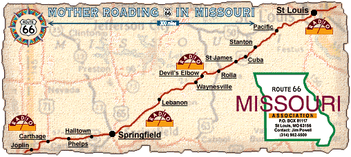
BEGINNING #1
Downtown St. Louis to Kirkwood via Watson Road - City Route 66 after
1933
Route 66 orginally entered St. Louis just north of downtown via McKinley
Bridge. Follow Salisbury to Natural Bridge Ave. Take a left on Florissant
until you come to 12th St (Tucker). Continue on Tucker to Gravois
Ave. Veer
right onto Gravois and drive to and turn right onto Chippewa. Look
for Ted
Drews Frozen Custard at 6726 Chippewa. Chippewa becomes Watson Rd.
Follow
Watson Rd to I-44 (City of Kirkwood).
BEGINNING #2 - THE ONE I AM GOING TO FOLLOW
Chain of Rocks to Kirkwood
via Bypass Route 66 around St. Louis
This newer alignment basically bypassed St. Louis while a City Route
66 went
into town. After Route 66 crossed the Mississippi River, it followed
the
basic path current-day Interstate 270 to Lindbergh Blvd. As far
as I can
tell, no evidence of the original road is left. At Lindbergh, you
go south,
passing through St. Louis' suburbs. In Kirkwood, Route 66 rejoins
City Route
66 at Watson Rd.
Kirkwood to Times Beach/Eureka
From Kirkwood, you follow Watson Rd till it joins Interstate 44.
For the
next 11 miles, you ride I-44. At Exit 266, Route 66 reappears north
of the
superslab. But you can't drive on it. This stretch of Route 66 is
closed
because of an environmental nightmare, Times Beach. When I last
drove this
road, cement barricades had been erected preventing you from crossing
the
Meramec River. You must continue on I-44 to the Eureka Exit.
Eureka to Gray Summit
Follow the north frontage road of I-44 through Eureka and then follow
the
I-44 Business Loop that goes through Pacific. At Gray Summitt, Route
66
follows Missouri 100 to the I-44/U.S. 50 interchange.
Gray Summitt to Sullivan (& Meramec Caverns) & Stanton
From Gray Summit, follow SR 100. After passing to the north of I-44
look for
the intersection with AT. Follow AT passing St. Mary's road and
Bock Rd. AT
turns into M and follow M past O to US 50. Cross over US 50 and
continue on
the north frontage road of I-44. As you approach St. Clair, cross
I-44 at
the Exit 242 to the south frontage road. Enter St Clair on Commercial
Ave.
Follow SR 47 south to SR 30. Route 66 continued straight after the
SR 30
intersection, but this is a deadend. Just after the SR 30 intersection,
turn
right and cross I-44 for the frontage road. Take the north frontage
road
west until the JJ intersection. Cross I-44 and use the east frontage
road
south. To visit the Meramec Caverns,
follow W. Continue on the east/south
frontage road through Oak Grove and to Sullivan.
Sullivan to Rolla
Follow Springfield Road (SR 185) through Sullivan. At Elmont, you
must jog
right to the west/south frontage road of I-44. Follow the south
frontage
road through St. Cloud to Bourbon. Follow the "Old Highway 66" signs
around
Bourbon. Continue straight past the intersection with C. Route 66
becomes
the south frontage road of I-44. In Cuba, Route 66 follows Washington
Blvd
to the intersection with SR 19. Continue straight on ZZ out of Cuba.
Continue along the south frontage road and KK to St. James. In St.
James,
Route 66 is James Blvd. On the west side of St. James, Route 66
becomes the
north frontage road of I-44. You can see what remains of Route 66
from
downtown St. James on James Blvd, but to continue your drive of
Route 66,
you must use SR 68 north, cross I-44, and go west on the north frontage
road. Continue on to US 63 and Rolla.
Rolla to Waynesville
Turn south on US 63, cross I-44 and enter Rolla on BUS I-44. Follow
Bishop
Blvd (US 63) to Kings Highway. Note: An older Route 66 alignment
followed
Pine St to 6th St and curved to Kings Highway. At Kings Highway,
follow BUS
I-44 back to I-44. Before I-44, take the south frontage road/Martin
Springs
Dr and follow this to Doolittle. Unfortunately, from Doolittle to
Arlington
and the Piney Rivers is a dead end road. You must use I-44 from
Doolittle to
the Jerome Exit (#172).
![]() with
pictures*****
with
pictures*****
Follow the north frontage road from the Jerome exit. At I-44 Exit
169, cross
to the south frontage road and continue on to Devil Elbow along
Z. This is a
4 lane stretch and one of my fondest memories
of US 66 before I-44 was
completed. Enjoy the rush through the hills
here and the fading, cracking
yellow paint that once marked Route 66 on
the concrete road.
(Devil's
Elbow)
There is a special side trip here. Just before you cross the Big
Piney
River, there is turn off to your left. This is an old section of
Route 66
that passed through Devils Elbow. It rejoins Z on the other side
of the
river. When I-44 peaks it's ugly head, continue on the south frontage
road
to St. Robert. Continue onto Waynesville and SR 17. Follow SR 17
south from
Waynesville back to I-44.
Waynesville to Lebanon
Cross over I-44 and continue on SR 17 to the junction of P and NN.
Turn
right onto P and follow it west to Laquey. Here, original Route
66 turns
south on AA. A newer version went straight and is under I-44 in
the
distance. Follow AA to AB and turn right. Continue to Hazelgreen
and then
drive west on the south frontage road of I-44. At F, cross I-44
and take the
north frontage road into Lebanon.
In Lebanon, Route 66 follow Seminole to Mill Creek Rd. Turn right
onto Mill
Creek Rd, then veer left onto Elm. Follow Elm out of Lebanon back
to I-44.
Lebanon to Marshfield
Follow W, the north frontage road of I-44. Route 66 did cross I-44
in this
section into Caffeyville, but the road is destroyed and did come
back to the
north of I-44. At Phillpsburg, cross I-44 on C and turn right CO
which
becomes the south frontage road of I-44. Look out for CC or a turn
off to
Conway and take this south away from I-44. Follow CC from Conway
and enjoy a
section away from I-44. Continue on to Marshfield. Through Marshfield,
follow Hubble Dr.
Marshfield to Springfield
Leaving Marshfield, briefly join SR 38 and then take a left on OO
(Washington). OO becomes the south frontage road of I-44. Follow
into
Strafford. In Strafford, continue straight on SR 744 into Springfield
(Kearney St.).
An original routing of Route 66 into Springfield from Strafford involved
going south on SR 125 to YY and heading west to Glenstone. In Springfield,
YY is Division.
Springfield
At Glenstone Ave, turn left (south) onto Business Route 65 and head
2 miles
to St. Louis St. Turn right (west) on to St. Louis Street. The road
will
split to go around the central square of town and rejoin, becoming
College
St. follow College St. to Chestnut Expressway and continue west
to I-44.
Alternative routings of US 66 include following Kearney from Glenstone
to
West Bypass (US 160). Turn left on West Bypass to College and turn
right
onto Chestnut Expressway (BUS I-44).
Springfield to Carthage
At I-44, you continue heading west on Missouri 266. This road stays
relatively close to the Interstate, but it's still far enough away
to
ignore. From here to Carthage, you get a glimpse of the upcoming
plains.
After Halltown, Missouri 266 turns into Missouri 96. Sections of
the
original road can be seen at times on the north side of the road
right-of-way.
A new spot to hit is Red Oak, MO. Check it out.
Carthage (Diner)
Visit the beautiful courthouse in downtown Carthage. Carthage is
home of
several Civil War battles.
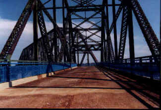
Route 66 entered Carthage on Central. At MO 571, it headed south
to Oak St
on Garrison. On Oak St (corner with Braum's Dairy Store), it headed
east
over the unusual bridge over the railroaad tracks and then angled
southwest
near the country club. After the road straightens out, you're blessed
with
the Route 66 Drive-in. The screen is still there as well as the
neon sign
out front.
Continue down this road till it bends to the left. You're on the
outskirts
of Brooklyn Heights. Cross over US 71 and continue to the T intersection
(Leggitt Road is the road sign I saw.) Follow this tree lined stretch
as it
curves SW then W again. At Pine (next T intersection), turn left
and head
south to Main St. ( I believe there is a street light here.) Turn
right
(West) onto Main and go through Carterville. On the western side
of town,
there is a zig-zag as Route 66 prepares to enter Webb City.
Webb City
After crossing over the railroad tracks, Route 66 met a fork in the
road.
Take the left fork (if you watch the cement, you can tell that a
previous
concrete road sweeped to the left) and this road turns into Broadway.
Follow
Broadway through downtown Webb City. Cross Main St and then turn
left onto
Webb St. Go 1/2 block again to Broadway and head out west again.
At
Jefferson (a school is on your left), turn south to MacArthur Blvd
(US 71).
Follow to Madison (or Ridge Line Rd) and turn left toward Joplin.
Alternative routings of Route 66 in the Webb City to Joplin include
following Broadway past Madison to Powell and SR 171. Continue on
SR 171 to
SR 43 and head south to 7th St. in Joplin.
Joplin
Follow US 71 (Ridge Line Rd) to Zora. At Zora turn right and follow
it to
Florida Ave (about a 1/4 mile). Take Florida to Utica St (about
0.2 mile)
and then notice how the road sweeps to the left. You're in front
of a
Nazarene Church. Turn to the left and drive down Euclid to St. Louis.
At St.
Louis (not marked, but the stop sign with the road that just went
across a
bridge), turn left and go across this bridge.
Follow St. Louis to Broadway. Turn right onto Broadway and head for
Main St.
At Main St., turn left (south) and head for 7th St.
An alternate route is following US 71 on Florida to 7th St and heading west.
In Joplin, Route 66 had two alignments. The original I just guided
you down
and the later one when I-44 was basially around. This newer Route
66 is now
MO 66 and crossed Joplin on 7th St. When US 66 was decertified in
Illinois
and most of Missouri, US 66 began at I-44 and SR 66.
What is strange and I hope to find something out about this. The
bridge over
the railroad tracks for 7th St is being repaired. The company doing
the work
has set up detours. Instead of using MO 66 signs, they are using
the Route
66 US highway shields. Why? I don't know, but it is odd and I checked
these
signs closely. They appear to be aluminum signs with 66 stickers
to them. I
WANT ONE!
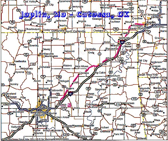
Joplin to Kansas State Line
head out of Joplin on Missouri 66 (7th St). As you get closer to
Kansas, (5
miles from downtown Joplin), watch for the green signs pointing
to the
original routing of Route 66 into Kansas. This section gives the
driver a
sense of the scale of mining done in the Galena area for lead and
zinc. You
can drive onto Galena on the newer alignment as well.
Total mileage ????? Estimate 300 miles
===============================
E-mail
================================
