|
|
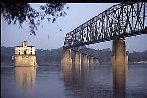 Once part of the fabled Route 66, the Old Chain of Rocks Bridge crosses one of the most historic and scenic sections of the Mississippi River. Officially opened in June 1999 as a multi-use recreational trail, the Bridge is 1-mile in length and 24 feet wide. It was named for the rocky shoals in the river just to the south. The Bridge offers a panoramic view of the St. Louis skyline and the Mississippi River, as well as, the old water-intake towers that pose as castles. It is part of the 40-mile riverside Confluence Greenway Project. Parking is available at the entrance to the Bridge on the Missouri side and along the street on the Illinois side. Hours of operation: Open daily (including holidays) from June 1, 2002 through May 31, 2003 from one-half hour before sunrise to one-half hour after sunset daily. Directions: From Missouri - (St. Louis County) Take 270 East, exit Riverview south. (St. Louis City) Take 55/70, exit Adelaide, go right to Hall Street, go left, to Riverview, entrance is at intersection of Interstate 270 and Riverview. From Illinois - Take 270 West, exit Route 3 South, then West on Old Chain of Rocks Road.
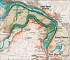
View a map of the Confluence Greenway.
|