NOTE: This file was scanned from the original document provided by the Virgnina Department of Transportation to the public at the May 27, 1999 Design Public Hearing. Every attempt has been made to include all of the informational content of that document. The format, however, has been modified to be consistent with online viewing. This document was scanned, and reformatted for online viewing by Peter T. Kleeman. Please email comments to Peter Kleeman at techniquest@netscape.net.
STATE PROJECT NO.
U000-104-102, RW-201, C-501
0631-002-128, C-502, B-612, B-657
PROJECT: U000-104-102, RIW-201, C-501
0631-002-128, C-502, B-612, B-657
FROM: 0.228km (0.14 Mile) SOUTH OF ROUTE 250 BYPASS
TO: 0.083km (0.05 Mile) NORTH OF ROUTE 631 (RIO ROAD)
BRIDGE OVER NORFOLK SOUTHERN RAILWAY
LENGTH: 3.323 km (2.06 MILES)
INTRODUCTION
The purpose of this Design Public Hearing is to provide an opportunity for any person, acting on his/her own behalf or representing a group or body, to offer comments or submit written material concerning the proposed Mclntire Road Extension project, also known as Meadow Creek Parkway Phase I. Arrangements have been made to take your oral testimony regarding the design aspects of this project. A comment sheet is also available, giving you the opportunity to offer written comments and suggestions regarding the design aspects of this project. All comments from this meeting, both oral and written, will be included in the official record. All comments and recommendations included in the record will be considered by the Commonwealth Transportation Board prior to its final decision regarding the design characteristics of this project.
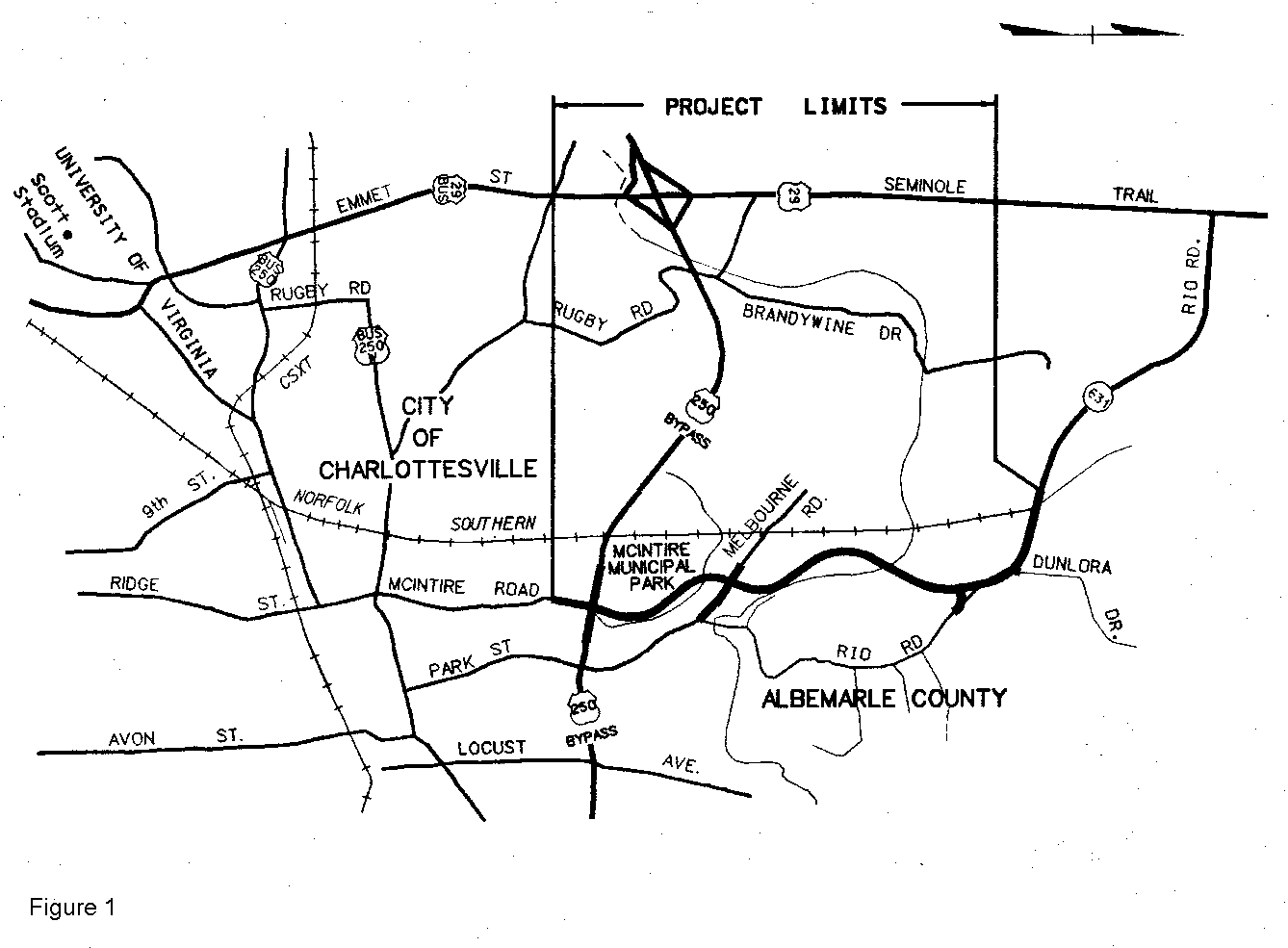
PROJECT DESCRIPTION AND LOCATION
The proposed project begins in the northeastern section of the City of Charlottesville and continues into Albemarle County. Construction of this project will begin 0.228 km (0.14 mile) south of Route 250 Bypass and will end 0.083 km (0.05 mile) north of the Route 631 (Rio Road) bridge over the Norfolk Southern Railway. The southern project limit ties into existing McIntire Road just north of Harris Street. The project then proceeds on new location from the Route 250 Bypass, crossing Melbourne Road with an at grade intersection, to meet existing Route 631 (Rio Road) in the vicinity of CATEC. The northern project limit is near the intersection of Greenbrier Terrace and ties into the widened segment of Route 631 (Rio Road). The project will provide two lanes for traffic in each direction, separated by a raised median or center turn lane. Left turn lanes will be provided at Route 250 Bypass, Melbourne Road, the Tie in at existing Rio Road, and Dunlora Drive. The total length of the proposed project is 3.3 km (2.1 miles).
PROJECT HISTORY
Plans for extending McIntire Road were first proposed in the Charlottesville Major Arterial Street and Highway Plan in 1967. The project later became part of the Charlottesville Area Transportation Study (CATS), Year 2000 Transportation Plan which was adopted by the Charlottesville/Albemarle County MPO in 1985. A Location Public Hearing was held for the project in 1986. Following the public hearing, progress on the McIntire Road Extension project was suspended because the City had concerns about traffic impacts on downtown Charlottesville and a pending decision on the Route 29 Bypass alignment. As a result, the southern terminus of the McIntire Road project was changed from Preston Avenue to the Route 250 Bypass.
On February 18, 1992, the Charlottesville/Albemarle County MPO passed a resolution amending the CATS Plan to include improvements adopted by the City, County and Commonwealth Transportation Board (CTB). The resolution included the McIntire Road Extension project. A second Location Public Hearing was held on April 26, 1994, due to the change in the southern terminus. The Location Corridor was approved by the CTB on September 15, 1994. After the CTB approval of the location corridor, a Citizen Information Meeting was held on October 15, 1996. Since that time refinements to the design have been made with input from the Meadow Creek Parkway Design Advisory Committee. This committee was appointed by the MPO members to provide community consensus on issues related to vehicle, pedestrian, bicycle, and transit transportation on the Meadow Creek Parkway.
PROJECT PURPOSE AND NEED
The purpose of this project is to provide improved traffic flow from the northern part of Albemarle County to the southern and eastern sections of the county, and to relieve congestion on Route 29 between Route 631 (Rio Road) and Route 250. The project will provide a more direct connection for county residents north of the city with downtown Charlottesville and will help reduce traffic from residential streets, particularly Park Street and the southern part of Route 631. The Extension will also provide improved access from the downtown area to Route 29 North.
TRAFFIC DATA
The 1999 Average Daily Traffic on existing McIntire Road south of the Route 250 Bypass is 22,800 vehicles per day. The 1999 Average Daily Traffic on Rio Road South of Penn Park Drive is 21,500 vehicles per day.
| The design year 2023 traffic projections on McIntire Road Extension are: | |
| Route 250 Bypass to Melbourne Road Melbourne Road to Relocated Rio Road Relocated Rio Road to Route 631 |
31,500 Vehicles/day 35,700 Vehicles/day 48,100 Vehicles/day |
The traffic projection for year 2023 on McIntire Road south of the Route 250 Bypass is 26,500 vehicles per day.
DESIGN
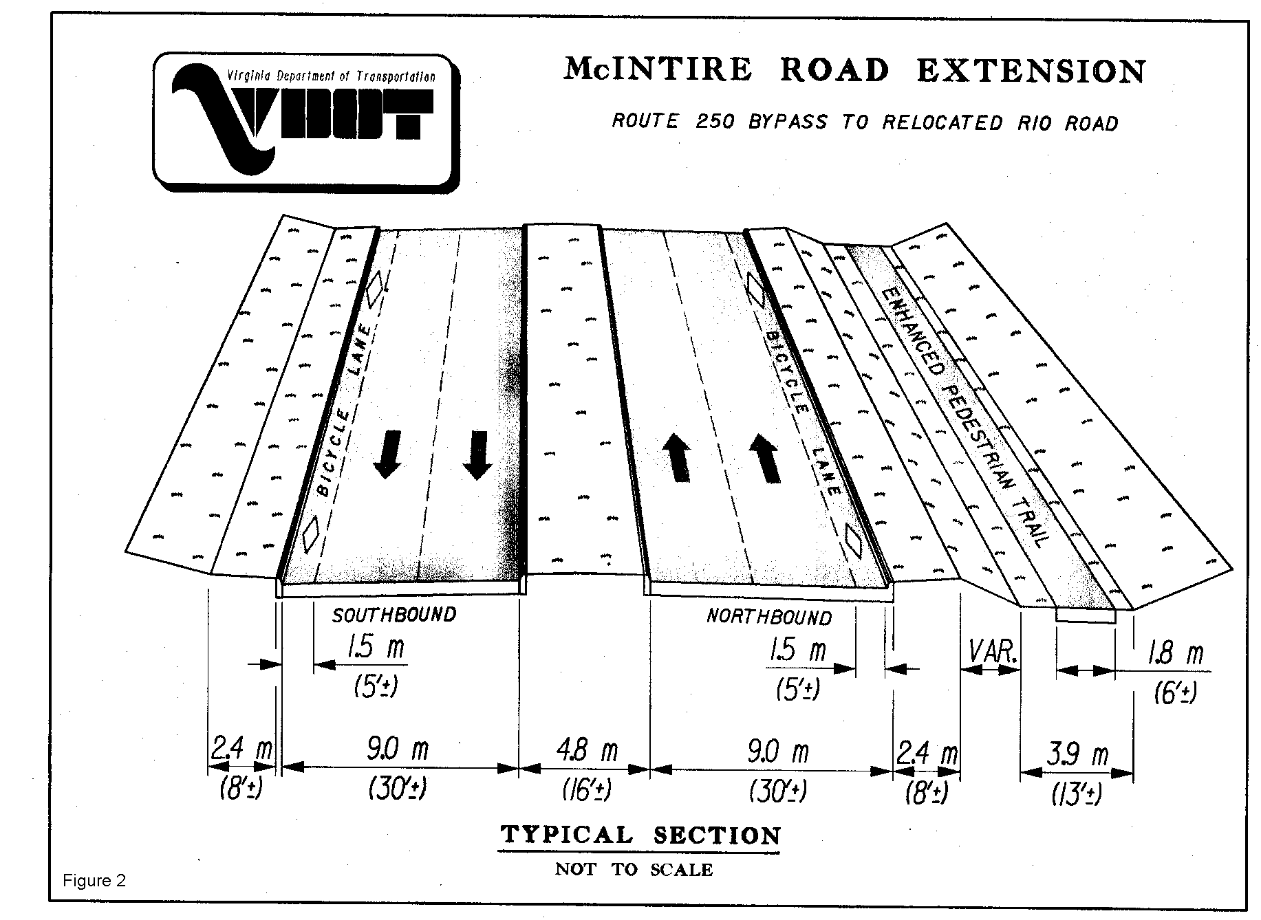
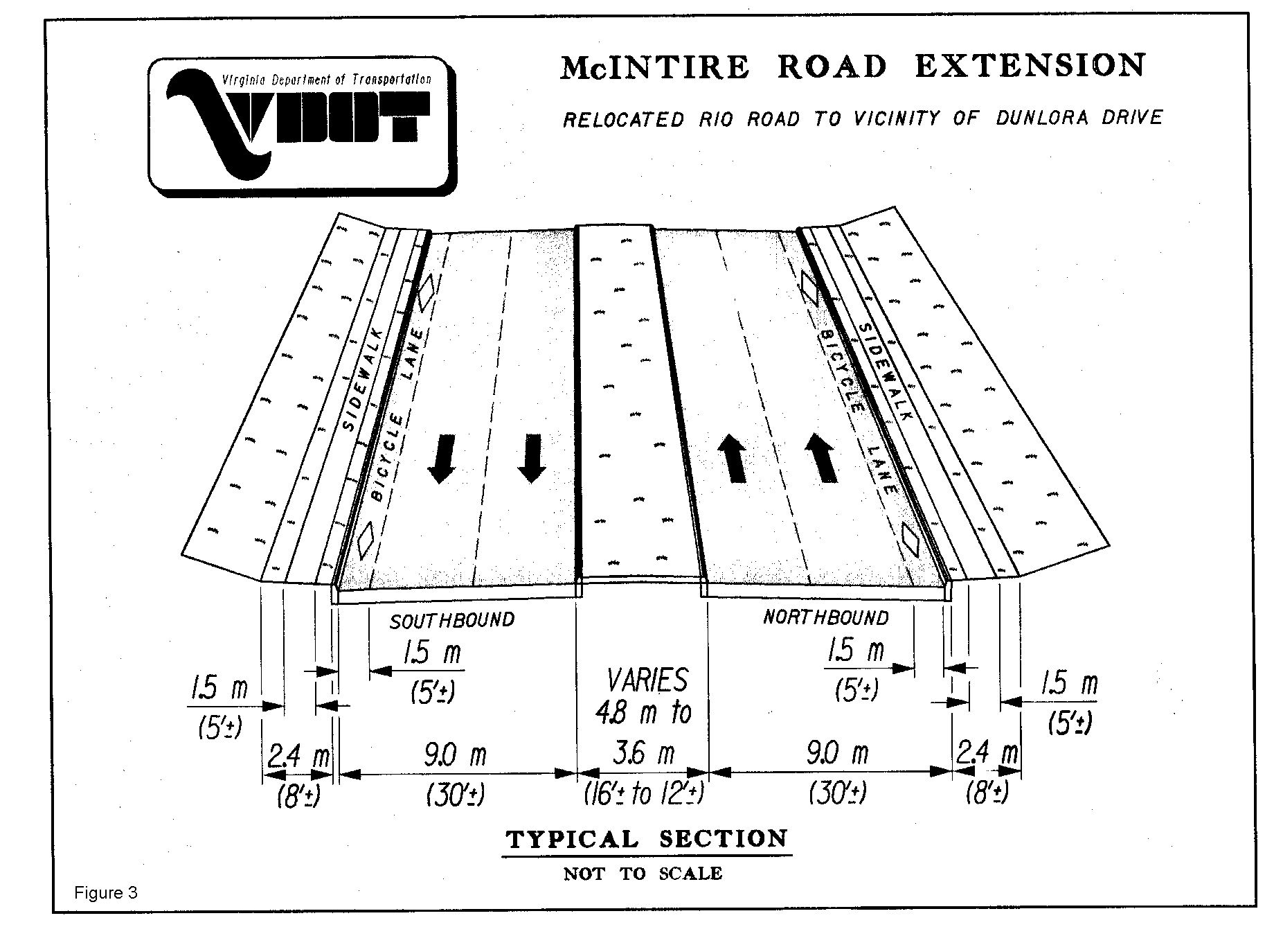
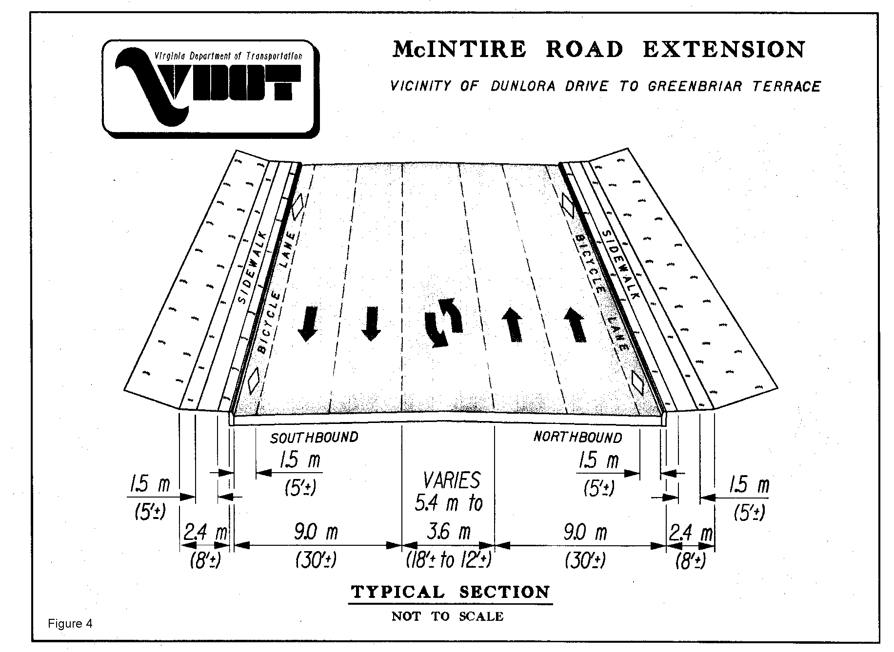
The proposed design provides a new four-lane divided highway with two 3.6 m (12 feet) lanes in each direction separated by a 4.8m (16 feet) and variable width raised median between Route 250 Bypass and just south of the Existing Route 631 (Rio Road) bridge over the Norfolk Southern Railway. The existing portion of McIntire Road south of the Route 250 Bypass will be widened from three lanes to five in order to receive the double left turn movement from the westbound Route 250 Bypass and accommodate a dedicated left turn lane for the northbound approach on McIntire Road. This widening only involves 200 m (650 feet) of Existing McIntire Road south of the Route 250 Bypass. At the northern project limit the roadway tapers to four lanes with a 3.6 m (12 feet) center turn-lane. A 1.5m (5 feet) bicycle lane is being provided on each side of the roadway along the entire length. A 1.8 meter (6 feet) enhanced pedestrian path is proposed on separate alignment between Route 250 Bypass and Relocated Rio Road.
A new bridge will be constructed to carry McIntire Road Extension over Meadow Creek and a new bridge is to be constructed to replace the existing Route 631 (Rio Road) bridge over the Norfolk Southern Railway. The roadway typical sections are illustrated in Figures 2, 3 and 4.
Dedicated turn lanes are proposed at the intersections of McIntire Road with Route 250 Bypass, Melbourne Road, Relocated Rio Road and Dunlora Drive. Traffic Signals are proposed at the intersections of McIntire Road/Route 250, McIntire Road/Melbourne Road, and McIntire Road/Relocated Rio Road.
Stormwater management ponds will be provided in accordance with State Stormwater Management Regulations. Four ponds are currently proposed on this project. As an alternative to these proposed ponds, a single regional wetpond located between McIntire Park and McIntire Road Extension is being considered. If a single regional wetpond is to be constructed in lieu of the four ponds, then additional funds from an outside source will be required.
Landscaping will be included in the project and will be coordinated with the City and County.
RIGHT-OF-WAY/IMPACTS
This project is being designed as a Limited Access Facility from the Route 250 Bypass to Relocated Rio Road. From Relocated Rio Road to the northern terminus at Route 631 (Rio Road) a minimum 26.1 m (86± feet) right-of-way width is required. Additional right-of-way will be required at turn-lanes, where the median is introduced and to accommodate bus turn-outs. Temporary construction easements and permanent drainage easements will also be required. As the project is finalized, permanent, utility and temporary construction easement locations shown on the public hearing plans may change. Minor improvements to adjacent streets may be required as part of this project. There are no relocations of residences or businesses.
ENVIRONMENTAL CONSIDERATIONS
The Project will require water quality permits for the impacts to Meadow Creek and Schenks Branch.
ESTIMATED COSTS
This project is estimated to cost $22.7 million which includes engineering, right-of-way, utilities and construction.
REMAINING ACTIONS
| Receive and Review Comments from Public Hearing Commonwealth Transportation Board Action Begin Acquisition of Right-of-Way Construction Advertisement |
Summer 1999 Fall 1999 Winter 1999 Spring 2001 |
WRITTEN COMMENTS
Written comments to be made part of the official record for this Design Public Hearing should be submitted within ten (10) days after this meeting to:
Mr. Donald R. Askew
Culpeper District Administrator
Virginia Department of Transportation
1601 Orange Road
Culpeper, VA 22701
(540) 829-7500