

~*~
* ~~~ * ~~~ * *** * ~~~ * ~~~ *
The following is the application (less the narrative which is not applicable) that asked for the recognition as a Virginia Historic Landmark and a listing on the National Register of Historic Places for the Ripley property at Purtan Bay in Gloucester County, Virginia. It was prepared by the Werowocomoco Research Group. (44GL32. DHR File #036-5049)
Added to it are corrections to the information submitted by the Princess Pocahontas Foundation in Bold type.
Betty DeHardit,
Princess Pocahontas Foundation
(Rev. 10-90)
NPS Form 10-900 OMB No. 1024-0018
United States Department of the Interior
National Park Service
NATIONAL REGISTER OF HISTORIC PLACES
REGISTRATION FORM
1. Name of Property
historic name Werowocomoco Archaeological Site
other names/site number 44GL32, DHR File #036-5049
2. Location
street & number 3051 Ginny Hill Road not for publication N/A
city or town Gloucester vicinity N/A
state Virginia code VA county Gloucester code 073 Zip 23061
7. Description
Summary Paragraph
The Werowocomoco Archaeological Site (44GL32) is a Native American village situated on Purtan Bay along the York River in Gloucester County, Virginia and which dates to the Late Woodland (A.D. 900-1607) and Early Contact (A.D. 1607-1609) periods. When the English founded Jamestown in 1607, it served as the capital of the Powhatan chiefdom and the principal residence of the chiefdom’s paramount chief, Powhatan. In 1609 Powhatan abandoned Werowocomoco and moved his capital further west to put additional distance between him and the English at Jamestown. Werowocomoco has been documented through archaeological surveys and excavations since 2002 to encompass 45 acres. It is in an excellent state of condition, being largely in pasture, agricultural fields, and forest as well as extensive lawns associated with a residence on the property.
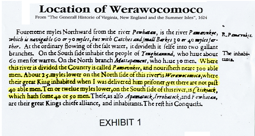
Captain John Smith’s description of where he was taken when he was captured is “Where the river is divided the country is called Pamaunkee, and nourisheth near 300 able men. About 25 myles lower on the North side of this river is Werowocomoco, where their great King inhabited when I was delivered him prisoner;” This places it at present day Wicomico about 13 miles from Purtan Bay. . (Smith's: Generall Historie of Virginia, New England and the Summer Isles (1624)
(
(Exhibit 1))
Background
Situated at Purtan Bay on the York River in Gloucester County, Virginia, the Werowocomoco Archaeological Site encompasses 45 acres of land currently in pasture, agricultural fields, forest, and residential lawns (Photo 1). This well-preserved site is the location of the capital of the Powhatan chiefdom in 1607 when the English arrived at Jamestown and served as the principal residence of the chiefdom’s paramount chief Powhatan until 1609. At that time he moved the capital further west due to the closeness of the English at Jamestown and growing hostilities between the English and Powhatans. As the capital of the Powhatan chiefdom at the time of the founding of Jamestown, Werowocomoco is of national significance.
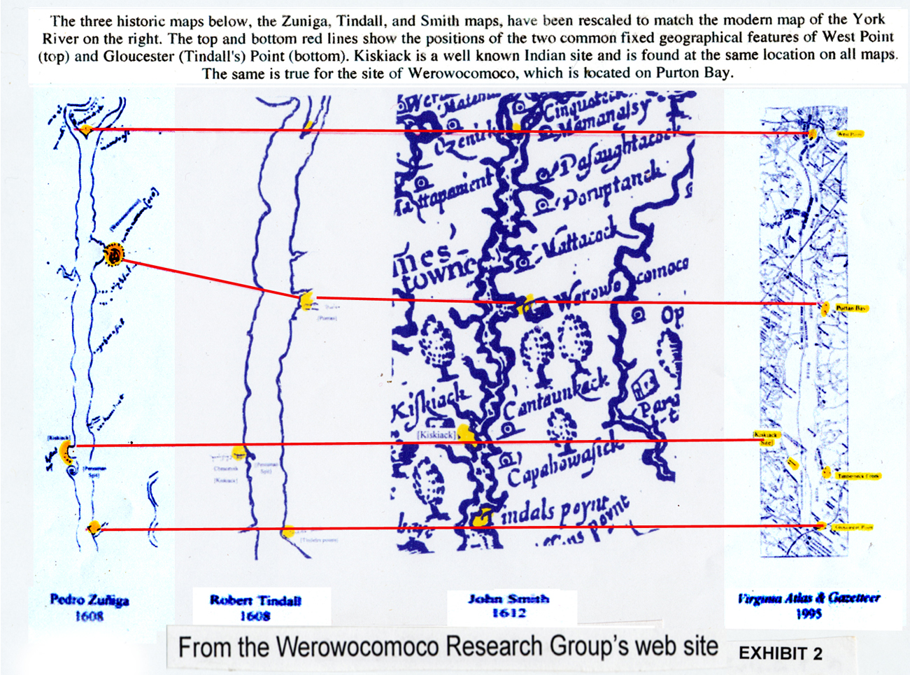
Its location at Purtan Bay is clearly established in historic maps and descriptions dating to the initial years of the Jamestown settlement. Efforts to identify Werowocomoco’s location draw on the Jamestown narratives and early maps of the region. Primary cartographic sources for Werowocomoco’s location include Tindall’s 1608 Draft of Virginia, the 1608 ZuŇiga Map, and Smith’s 1612 Map of Virginia. Tindall’s Draft represents the oldest surviving map prepared by a Jamestown colonist (Mook 1943). The enigmatic Zuniga Map was originally identified in a Spanish archive with an accompanying 1608 letter to Philip III of Spain from Don Pedro de Zuniga, Spain’s ambassador to England, informing him of developments at Jamestown. The map appears to be a copy of a sketch John Smith sent to England along with his True Relation (Barbour 1969:238).
If the Zuniga map was a copy of Smith’s map, it is a very, very poor one. It had a drawing on it that is not on Smith’s map, and no identifiable creeks along the York River that are on Smith’s map. About the only thing identifiable that is on Smith’s map, is the division of the York River at West Point. (
(Exhibit 2).)
Don Pedro Zuniga was the Spanish ambassador to England and a spy for the King of Spain. Alonzo de Velasco was another. “ [Don Pedro de] Zuniga [former Spanish ambassador to England] has removed to the house of the Lieger Ambassador, Alonzo de Velasquez [Velasco], in the Barbican, that he may more freely transact his secret business. …….. He sends scandalous reports of English affairs to Spain and Italy” (Alexander Brown, 1890 “The Genesis of the United States”)
Smith’s formal Map of Virginia was subsequently published in 1612 accompanied by text describing Powhatan society. This well-known map went through at least eleven revisions and multiple printings (Stephenson and McKee 2000:28). The Zuniga, Smith, and Tindall maps are oriented such that west is at the top, reflecting a reference point from the Chesapeake Bay or the Atlantic Ocean. Portions of each of these maps for the York River environs, provided at the same scale, can be seen in Figure 1. Using known landmarks such as the confluence of the Mattaponi and Pamunkey rivers at modern-day West Point, the village of Kiskiack at the U.S. Naval Weapons Station (see below), and Gloucester Point at the mouth of the York River, the maps clearly place Werowocomoco at Purtan Bay.
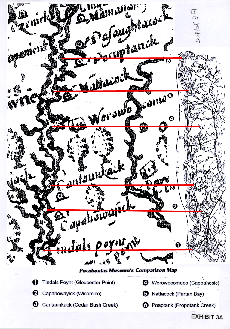
The Research Group’s comparison map is not to the same scale. Their comparison is an alteration of a comparison of Smith’s map and a modern map in the Pocahontas Museum in Gloucester, Virginia. Dr. Randolph Turner (a member of the Virginia Department of Historic Resources and the Werowocomoco Research Group) saw it in 2000, when he visited the museum to identify Indian artifacts that were brought in by citizens. In the museum’s comparison, Poropotank Creek and Gloucester Point are lined up on Smith’s map with a modern map. (
(Exhibit_3A)
Early maps were not that accurate. In “Virginia in Maps” by Richard W. Stephenson & Marianne M. McKee, 2000, is; “William Hole (who drew Smith’s map) was not noted as a cartographer when he prepared the Smith map. He borrowed images from Theodore Harrior’s 1585-1586 description from the Roanoke colony. In addition to topographical information, the map included several vignettes about the region.”
In “History Matters, the U. S. Survey Course on the Web, Tools of the Historian: Empires, Maps and Meaning” there is“ Even historians who are sensitive to their own role as interpreters of the past, however, are sometimes guilty of treating materials such as maps as presentations of facts. ……. Those who design maps assume they know or make assumptions about which places, boundaries, people and activities should be highlighted, which are secondary, and should be excluded all together.”
Werowocomoco was the name of the present day Wicomico area until 1900 when a Post Office was established there by John Edwin Hogg. The U. S. Post Office Department rejected Mr. Hogg’s submission of the area’s name, Wowocomoco, as too long. They named the Post Office “Wicomico” instead. If this had not occurred, there would no confusion today!
Among maps around that time that show Werowocomoco at the Wicomico are; “Part of Colonial Virginia drawn and engraved to accompany Cook’s Virginia” in 1883, and the map in “Barnes’ History of the United States” by James Baldwin dated 1907.
Obviously, the comparison map in the Pocahontas museum impressed Dr. Turner, because he used an altered version of it when he made the announcement of “finding” the location of Werowocomoco to the press. (
(Exhibit 2)
In order to place Werwocomoco on Smith’s map at Purtan Bay on the modern map - the location the Research Group claim it was - they had to reduce the modern map. In doing this, it now placed Purtan Bay (Nattacock) on Smith’s map at Propotanks Creek on the modern map. It also placed Propotanke Creek on Smith’s map up near West Point. (
(Exhibit 3A),
(Exhibit 3B))
In the museum’s comparison, all the locations on Smith’s map appeared at locations known today as Indian sites.
Robert Tindall, one of the original colonists, accompanied Christopher Newport to the villages of Powhatan and Werowocomoco (Barbour 1969:104-107). Tindall describes himself in a letter as “gunner to Prince Henry” and later references indicate he became a master mariner (Mook 1943:373). Tindall’s map includes a remarkable amount of accurate detail given its early date, depicting the James from its mouth to the village of “Poetan” (i.e., Powhatan) symbolized with anicon of a yihakan (house). “Prince Henry’s River” (i.e., the York) extends from its mouth to a location west of the Pamunkey – Mattaponi confluence. The village of “Pamonke” (i.e. Pamunkey) appears in a location west of this confluence that approximates the area of the contemporary Pamunkey Reservation. Downstream from the Pamunkey – Mattaponi confluence on the north side of the York, Tindall depicted a second village labeled Poetan, this one signified by four Native houses. The shoreline at Poetan suggests a bay fed by three streams that enter in the vicinity of the village. Scholars (e.g., Brown 1890:151,188; Tyler 1901; Mook 1943:379) have long agreed that “Poetan” represents another name for Werowocomoco given that the village was known primarily as Powhatan’s residence, and Tindall was known to have visited the location.
Tindall’s map only shows two creeks ( possible Propotank and Little Propotank that are above Purtan Bay) on the North side of the York River from Gloucester Point to West Point, both above the “Poetan” they mention. There are five others along the York River, Timberneck Bay, Carter’s Creek, Aberdeen Creek, Jones’s Creek, and Fox’s Creek between Gloucester Point and Purton Bay.
The Zuniga map shows only one creek on the north side of the York River at the location of the “D” mentioned by the Research Group. It is so large it appears to be a river, not a creek. (
(Exhibit 2).)
Lyon G. Tyler, historian, in 1901 was the first persons to suggest that “Purtan Plantation”, located on the upper side of Purtan Bay, not the Ripley property, was the location of Werowocomoco. It is about 12 miles up river from the traditional location at Wicomico. The claim was that Purtan was an alteration of “Poetan” which was an alteration of “Powhatan”. This does not apply to the Ripley Property. The name of their property was “Glenco” until they changed the name to Werowocomoco in the last year or so.
The idea that Poetan was an alteration of Powhatan and that Powhatan stands for Werowocomoco takes a lot of imagination. The name “Poetan” is a family name. There is a “Poetan’s Swamp” in James City County, Virginia (the location of Werowocomoco?). There is “ Purton Village” a town in Wilshire, England, “Purton” is also a family name. There is a “Purtan Industries” in Gloucestershire, England”
On the other hand, a location named Powhatan does not necessarily stand for Werowocomoco either. If this were so, Powhatan near Richmond, Virginia, could also be the location of Werowocomoco, and - as the Research Group claim - where Capt. John Smith was saved by Pocohontas!
It is more likely that Purtan Plantation and Purtan Bay were named after a locations in England, as so many other locations in Gloucester County are, like “Gloucester” itself.
The only other York River settlement depicted on the map is “Chescoyak” (i.e., Kiskiack), a village that functioned almost as a gateway to Werowocomoco for the English who generally traveled by boat (Underwood et al. 2003). Consistent with other early maps, Kiskiack is placed on the southwest side of the York upstream of its mouth. Recent research conducted by the William and Mary Center for Archaeological Research (Underwood et al. 2003) has identified the archaeological site of Kiskiack on the grounds of the Naval Weapons Station, a location that corresponds closely with Tindall’s Draft. Tindall’s Draft lacks a scale, making distances on the map unclear. However, by using the approximately 25 mile distance from the Mattaponi-Pamunkey confluence (today’s West Point) to “Tindall’s Point” (today’s Gloucester Point) as a gauge, distances from Poetan / Werowocomoco to other reference points on the York may be estimated accurately. The distance from Pamunkey village to the Pamunkey – Mattaponi confluence is approximately 5 linear miles or 10 – 15 miles by river. The distance from the Pamunkey Mattaponi confluence to Poetan / Werowocomoco is 11 miles, while the distance from Poetan / Werowocomoco to Chescoyak / Kiskiack is approximately 10 miles, and the distance to Tindall’s / Gloucester Point is approximately 14.5 miles. These closely match distances from Purtan Bay as measured on a modern map of the York: Purtan is 11 miles below West Point, 11 miles above the Naval Weapons Station at Indian Field Creek, and 14 miles upriver from Gloucester Point. Tindall’s Map also accords well with the York River shoreline at Purton Bay, which is fed by Purtan, Leigh, and Bland creeks, Given this rather remarkable congruence...
This application says ”Tindall’s map lacks a scale, making distances on maps unclear” (see above) There is no way to determine what a mile was on the map, It also ignores Smith description of where the village was, that is,” about 25 miles from where the river divides” at West Point and that Kiskiack was 12 miles from Werowecomoco not the other way around. (Smith's: Generall Historie of Virginia, New England and the Summer Isles (1624) (
(Exhibit 1).)
...it is not surprising that scholars have long agreed that Purtan Bay represents the location of Werowocomoco.
Actually, the earliest that anyone suggested that Werowocomoco was not at Wicomico, its traditional location, was Tyler in 1901. (according to the Werowocomoco Research Group!)
The Zuniga Map adds additional detail to the York River landscape and expands the region covered to include areas to the south of the James described by Roanoke colonists as well as the Rappahannock and Potomac drainages. The map is consistent with Tindall’s in the relative placement of Jamestown, Werowocomoco, Kiskiack, and the Mattaponi-Pamunkey confluence. The Zuniga Map includes the names of 68 villages Smith visited prior to June 1608 and additional names beyond the core James / York area apparently drawn from Native informants and from reports of the Roanoke Colony (Barbour 1969:238). Notations on the map include the expression “20 miles above this C. S. [word crossed out] was taken” and dotted lines that trace the route on which Captain Smith was taken during his captivity.
Several villages, including Kiskiack on the York, are identified as a scatter of dots (apparently depicting houses) lining the riverfront or embayed areas along the river. Additional notation on the map includes the path Smith took during his December 1607 – January 1608 captivity and scattered dots that appear to represent dispersed house locations in some Powhatan villages. At Werowocomoco the cartographer added an unusual set of symbols that appear as dots surrounding a double “D” shaped pattern. Within the two “D”s are three additional dots.
Werowocomoco is not the name written at the location the Research Group describes on the Zuniga map. You will note that in the picture of it from their web site, the name does not even have enough letters to spell it. In addition, on that picture someone has added “(oco)” to the end of the name to give the impression that it does! (
(Exhibit 4).)
Above the picture, the Research Group has also written “Waruwocomoco”, possibly because the letters after the “W” on the Zuniga map appear to be “Watuw---” not “Werow-” or “Wera---” as sometimes spelt in Smith’s book (
(Exhibit 4))
“Scattered dots (apparently depicting houses)” may be true, but it does not prove the location of any specific village.
The Research Group said that the Zuniga map is a copy of Smith’s, but the Zuniga map and no other map show this “D”. We find “Werowocomoco” on maps after 1800 at Tinberneck Creek. Among these maps are; “Part of Colonial Virginia drawn and engraved to accompany Cook’s Virginia” in 1883, the map in “Barnes’ History of the United States” by James Baldwin dated 1907, and “Chief’s Powhatan’s World, 1607” in “Love and Hate in Jamestown: John Smith, Pocahontas, and the Heart of a New Nation” by David A, Price, published in 2003.
The significance of this notation is unclear, but its large size clearly conveys its strategic importance alongside Jamestown. Clearly a detailed sketch drawn by someone with much greater familiarity with the James and York than areas beyond these rivers, the document is particularly valuable as an informal map drawn by hand “in the field” rather than as a formal, engraved map. The map apparently reflects Smith’s recordation of a Chesapeake landscape that he experienced first-hand more broadly than any other colonist while Powhatan resided at Werowocomoco.
The Research Group is writing about Zuniga’s map - not Smith’s. Zuniga never visited the new world, and it has never been proved that his map is an actual copy of Smith’s map. It is only a theory. They certainly do not resemble each other except for the division of the York River at West Point. (
(Exhibit 2))
As Turner and Opperman (1993:72) (Turner is Randolph Turner, a member of the Research team) have noted, the chaotic mix of dots, blobs, and odd marks on the Zuniga map likely reflects Smith’s efforts to characterize an unfamiliar landscape of dispersed Native villages and community forms with which he was unfamiliar. Smith’s later Map of Virginia clearly evolved out of some version of the Zuniga Map...
First the Research Group says that – “ the Zuniga map is a copy of Smith’s sketch”, now they say – “Smith’s map evolved out of some version of the Zuniga map”. Which is true? Actually there is very little similarity between the two maps. (
(Exhibit 2))
...though the later document had changed considerably as it was standardized according to the formal mapmaking style of early seventeenth-century England. Where Smith had experienced the Chesapeake landscape while passing through it (as indicated by the captivity trail on the Zuniga Map) the formalized Map of Virginia effectively obscured the events leading to its creation.
It is only a theory that the Zuniga map shows the captivity trail of Smith, and an unlikely one at that, since it is not shown on Smith’s map and Zuniga was not with Smith or even ever in America.
This concealment parallels a broader colonial process: beginning in the fifteenth century European colonists’ narrative accounts of new places were replaced by maps, documents that “colonized” space in the process (de Certeau 1984:118-122). Named places associated with varied topologies, histories, and memories were conflated through their inclusion on the same Cartesian plane. Smith’s Map of Virginia achieves this by excluding much of the detail found on the ZuŇiga Map, detail that may prove valuable in understanding the Chesapeake cultural landscape circa 1607.
Smith’s map has more details, (
(Exhibit 2),
(Exhibit 3A))
Even so, Smith’s 1612 Map of Virginia is invaluable for its comprehensive coverage of the Chesapeake region and its accurate rendering of Virginia tidewater physiography. Distances on the map from Werowocomoco closely match those on the Tindall Map. Werowocomoco is depicted as 14 miles upstream from Tyndall’s Point and 9 miles above Kiskiack. It is also 11 miles below the confluence of the Pamunkey Ritver (labeled here as the “Youghtanund”) and the Mattaponi.
The Virginia State Library said that Tindall’s map looked like human intestines! The Research Group said that in this application the “Tindall’s map lacks a scale, making distances on maps unclear” So, how do they determine the mileage? Also, the group start their measurements at Tindall Point whereas Smith started his at West Point, - (Smith's: Generall Historie of Virginia, New England and the Summer Isles (1624)
The shoreline includes a bay and indentations suggesting three creeks. The map has, however, excluded most of the notations found on the Zuniga Map. Settlements are depicted as either points (ordinary houses) or yihakans (kings’ houses). The map implies a uniformity and spatial boundedness to Native settlements that fail to match the archaeology of Contact period settlements. Such settlements generally consist of dispersed villages with variable communal organization (cf. Turner and Opperman 1993). (again Turner is a member of the Research Group) The cartographic sources may be combined with other written references to Werowocomoco’s landscape in order to determine whether Purtan Bay matches these descriptions. From Smith’s second (1986a:63) visit to Werowocomoco we learn that the village was situated on a shallow bay some 12 miles from Jamestown that was choked with “ooze” and fed by three creeks all “within lesse then a mile” with the York River channel being 1 1/2 miles away.
It was previously said by the Research Group that the Zuniga map is a copy of Smith’s map. The above appears to say it was the other way around. This would be remarkable since Zuniga never visited America.
There is “ooze” at Wicomico and all along the York River. The truth is that Wicomico is 12 miles from Jamestown and Purtan Bay is about 15 miles from Jamestown.
In the text of his Map of Virginia (1986b:173) Smith modifies the distance from Jamestown slightly to 14 miles. Smith described the confluence of the Pamunkey and Mattaponi rivers and Native settlements in this region, noting “Where this river is divided the Country is called Pamaunke, and nourished 300 able men. About 25 miles lower on the North side of this river is Werawocomoco, where their great king inhabited when Captain Smith was delivered him prisoner” (1986b:147).
This quote is from Philip L. Barbour’s book, “The Complete Works of Captain John Smith”. However. the exact quotation of what Smith’s said is “where I was delivered” (Smith's: Generall Historie of Virginia, New England and the Summer Isles (1624) (
(Exhibit 1))
Smith also offers some indications of Werowocomoco’s layout by describing Powhatan’s house as situated thirty score from the water. Whether this refers to a distance of 600 feet or 600 paces (or roughly 1,500-1,800 feet) is left unclear in the text, yet the implication is that Powhatan met Smith and Newport in a structure spatially removed from the riverfront. Smith’s references to the shallow bay fed by three creeks fits the Purtan Bay area well with Purtan, Leigh, and Bland creeks being present here. These three creeks are all within less than one mile of each other, and the York River channel is over one mile to the east of the mouth of Leigh Creek. Smith’s comment on the “ooze” here is a well know feature of Purtan Bay and its broad but very shallow nature.
“Ooze” is known at many locations on the York River. Timberneck Bay has three creeks - Timberneck, Cederbush and Sally White’s Cove
Purtan Bay is located 13 miles northeast of Jamestown, again, according with the Map of Virginia.
The Research Group said before it was located 12 miles from Jamestown. Timberneck Bay is 12 miles from Jamestown; Purtan Bay is about 15 miles from Jamestown.
On first glance, Smith’s reference to Werowocomoco as 25 miles below “where the river is divided” is puzzling. Traveling 25 miles below the Pamunkey /Mattaponi confluence on the York takes one to Gloucester Point.
Smith said “about” 25 miles from West Point, Virginia. Timberneck Bay is about three miles from Gloucester Point. - (Smith's: Generall Historie of Virginia, New England and the Summer Isles (1624) (
(Exhibit 1))
Purtan Bay is only 12 or 13 miles from West Point, about half the distance.
The three early seventeenth-century maps of the area described above consistently place Powhatan villages (including Werowocomoco) well upstream of this location. In fact, if the village of Kiskiack was indeed roughly 10 miles downstream of Gloucester Point that would place it at the York River mouth. Returning to the text, though, it is clear from the first sentence in the passage that Smith is referring to the “Country called Pamunkey” rather than the confluence of the Mattaponi and Pamunkey rivers (Montague 1972).
“the County is called Pamaunke” does not mean “a village some 13 miles upstream from where the river is divided”. If you say “at Gloucester Point the county is called Gloucester” are you referring to Gloucester Court House 12 miles away?
Neither the Tindall map nor the Zuniga map shows any location as Werowocomoco.
The core of Pamunkey territory was located some distance west of the Pamunkey River’s mouth. In fact, the village labeled “Pamonke” on Tindall’s map of the York was located approximately 21 – 26 miles upstream from what is today Purtan Bay. A related and intriguing explanation to Smith’s 25 mile reference can be found on the Zuniga map. Roughly 25 miles upstream from the location of Werowocomoco, the map shows an island in the Pamunkey River with the river here dividing around the island.
One could not ignore the division of the river at West Point and go several miles up the Pamunkey River to an island and call that “where the river divides”. One would not call a river going around an island ”where the river divides”. In fact, the only thing that is shown the same on all three maps, Smith’s, Zuniga’s, and Tindall’s, is the division of the York River at West Point.
The York River is a very unusual river. At West Point, it divides into two separate new river of about equal size. They are not branches or creeks that flow into the York River, they are actually two separate rivers that join at West Point. They even have different names, Pamunkey and Mattaponi. At West Point they join and become a different river -–the York River. (
(Exhibit 2),
(Exhibit 3A),
(Exhibit 3B))
It is conceivable that this location, in the heart of Pamunkey territory, was what Smith was referring to in his reference on "where the river is divided.”
See the last reply.
Despite the overwhelming evidence for Werowocomoco being at Purtan Bay, one additional location needs review. William Stith in his 1747 History of Virginia suggests that Werowocomoco was in the Shelly-Timberneck area to the east of Purtan Bay based upon a misreading of Smith. This appears again in publications by Charles Campbell and Henry Howe dating to 1845 and 1846 which in turn was repeated by William Meade in 1857. As documented by Montague (1972), focus was placed on a ruined chimney that was named “Powhatan’s Chimney” and attributed to be what remained of a house the English were to build for Powhatan in 1609. Stith’s mistake was in taking a quote by Smith (see above) about Werowocomoco being 25 miles below Pamunkey territory
The Group now claims it as fact! Smith did not say “Pamunkey territory” he said, “where the river divides”. (
(Exhibit 1))
See quotations later from Campbell, Meade and Page on Powhatan’s Chimney.
and assuming that the measurement began at the confluence of the Pamunkey and Mattaponi rivers, which is modern-day West Point. Following this approach, others have assumed that the ruined chimney at Timberneck Creek marked the location of Werowocomoco. However, measuring 25 miles from West Point places one at modern-day Gloucester Point (but not at Timberneck Creek which is over three miles to the west),
Again, Smith said “about 25 miles” not “25 miles” He also describes it another time as 20 mile from West Point. Purtan Bay is only 11 or 12 miles from West Point, a big difference. (Smith's: Generall Historie of Virginia, New England and the Summer Isles, 1624) (
(Exhibit 1))
a location totally inconsistent with the early 17th-century maps noted above. Further, and critical here, is the remainder of Smith’s statement, which advocates of the Timberneck location ignore; Smith specifically notes that the village of Kiskiack is 10 to 12 miles below Werowocomoco.
The Research Group say positively that Smith is wrong when he said the location of Werowocomoco was 25 miles from where the river divides, but he is right when he “specifically notes” that Kiskiach is 12 miles from Werowocomoco!
which if located at Timberneck Creek would place Kiskiack well past Gloucester Point, a position totally inconsistent with the Tindall, Zuniga, and Smith maps! In actuality, the village of Kiskiack has been recently identified as being at the U.S. Naval Weapons Station which as noted above, is 11 miles below Purtan Bay, a perfect fit with the Smith quote and consistent with the location provided on the above-noted maps (see Figures 1 and 2).
The Kiskaick Indians moved quite a bit. They started at Poquosan flats. Finally they crossed the York River and ended up at Cash. There is a road on Route 14 about three miles from Main Street, Gloucester, named Indian Road, and traditionally said to be the road that the Kiskiak Indians traveled. Frances Lamb’s map, “A Map of Virginia and Maryland” 1676, show that the Kiskiak (Cheeseak) Indians were in Gloucester on the Piankatank River at that time.
In “Records of Colonial Gloucester Virginia” by Polly Cary Mason, Augustine Warner was granted 2500 acres in 1682 - “On the S side if Paenkatank R. lying about the branches of old Cheescake town & adjoining Indians land to SE of old Chiscake”
Additional inconsistencies can be found when comparing the location of Timberneck Creek with Smith’s description of the bay and three creeks at Werowocomoco. As discussed above, Smith notes Werwocomoco being in a shallow bay with three creeks all of which were within less than a mile distance. This is a perfect fit for Purtan Bay and the three creeks there. The same is not true of Timberneck Creek which is not part of a bay with the two nearest creeks, Cedarbush and Carter. Further, the distance from Timberneck Creek to Carter Creek is approximately three miles and not the “within lesse then a mile” distance Smith notes and what actually occurs at Purtan Bay.
The York River has changed over the years. There is constant erosion. Meade, Campbell and other early historians described the area where Powhatan’s Chimney is located as Timberneck Bay. There are three creeks in that area, Timberneck, Cederbush and Sally White’s Cove.
Even the actual marl chimney at Timberneck Creek is inconsistent with what one would expect for English construction in 1609. As recent archaeological research at Jamestown has documented, early structures were of simple construction with chimneys typically not made of brick or stone. Had the massive chimney (made of marl blocks that had to be quarried from the York River cliffs and then brought to the site) been constructed in 1609, it would have been far superior to anything at Jamestown and certainly would have been commented on (Montague 1972).
Charles Campbell in “ History of the Colony and Ancient Dominion of Virginia” published in 1860, wrote:
“ Powhatan and the treacherous Dutchmen who had been sent to build him a house, and who were attracted to the abundant good cheer that they enjoyed at Werowocomoco, now together plotted Smith’s destruction. ……….As the party sent forward to build the house had been there about two weeks, and as the chimney is erected after the house, it may be probably inferred that ‘Powhatan’s Chimney’ was built by the Dutchmen. It indeed looks like a chimney of one of those Dutch houses described by Washington Irving in his inimitable ‘Legends of Sleepy Hollow’ It is the oldest relic of construction now extant in Virginia and is associated with the most interesting incident in our early history. This chimney is built of stone found on the banks of Timberneck Bay and easily quarried”.
Thomas Nelson Page in “Old Yorktown”, published in Schribner’s Monthly, October 1881 wrote;
“A few miles below here on the buff in Powhatan’s Chimney, the sole remaining relic of the royalty of the old Indian king. It had the honor of being built by Captain John Smith, and was erected on the requisition of the king for ‘a house, a grind stone, fifty swords, some guns, a cock and hen, with much copper and many beads’, The fireplace is wide enough to roast an ox, and there is great suspicion that it has served to roast other cattle – Payankertank rebels and the like.” Scribner’s Monthly also printed a picture of the chimney. This was before the chimney fell down in 1888.
There are two other constructions made of marl built in this area. One is Grace Episcopal Church in Yorktown built in 1697 and the other “The Old Stone House”: in James City County, also built by Smith.
It is to be noted that the Research Group has to discredit Powhatan’s Chimney because it was built at Werowocomoco, and exists as proof of the location of that Village. (Smith: Generall Historie of Virginia, New England and the Summer Isles (1624)
Finally, the limited archaeological research at the chimney does not support an early 17th-century construction date (Brown 2001).
Brown is David Brown, a member of the Research Group. There has never been archaeological research performed at the Catlett’s Island where abundant numbers of Early Archaic to Late Woodland Period artifacts have been found, nor has there been one at Carmine’s Island, both at Wicomico. It use to be a regular event for the neighborhood of Powhatan’s Chimney to pick up Indian artifacts around the chimney
In short, there simply is no evidence to suggest that “Powhatan’s Chimney” was ever actually associated with Powhatan or even built during the initial years of the Jamestown settlement.
Bishop Meade, who visited the chimney in the early 1830’s said in his book “Old Churched, Ministers and Families of Virginia” published in 1857:
“On a high point of land divided by Timberneck Creek and Mr. Catlett’s farm, the former seat of the Manns, there is a wooden frame room, of recent construction, attached to a low Dutch-built chimney intended only for a single story house. The chimney has recently been covered on the outside with a coat of plastering. The fireplace within was eight feet four inches wide -- that is the opening to receive the wood -- and four feet deep, and more than six feet high, as that the tallest man might walk into it and a number of men sit within it around a fire, All this was royal enough; but as any of the old chimneys in Virginia, especially of the negro quarters, were as large in former days, when wood abounded, my skeptician was not entirely removed until I perceived, in the only crack that was to be seen outside of the wall, something which showed that the material was no ordinary kind of stone, but like that of which the old church of York was built, -- via: marl out of the bank, which only hardens by fire and by exposure. To render this more certain, I asked the owner of the house if he would not get me a small block of the material from the bottom of the chimney, near the ground so as not to injure it. He obligingly consented and bringing an old axe, by repeated and heavy blows disengaged from the chimney a fragment of it, which I found to be what I had conjectured, -- a particular kind of marl, composed of shells, and which abounds on some of the high banks of the York River, on both sides, I am now satisfied that this is really the stone chimney built by Captain John Smith.”
Taken together, the documentary and cartographic sources leave no doubt that the Purtan Bay vicinity represents the location of Werowocomoco. Besides Montague’s contribution noted above, other scholars confirming the Purtan Bay location include Brown (1890), Tyler (1901), Gray (1934), Mook (1943), Lewis and Loomie (1953), Noel Hume (1994:225), Rountree (1989, 1990, 2005), Haile (1998), and McCartney (2001). This view also has been presented in recent publications by the Association for the Preservation of Virginia Antiquities (Kelso and Straube
2004:24; cf. Packer 1989:7 and Lindgren 1993:42-43.), Virginia Department of Historic Resources (Turner 2003), Gallivan et al. 2005), National Park Service (Rountree et al. 2005), and National Geographic Society (Borne 2005:49).
None of these writers published before 1890. Turner is a member of the Research Group and is employed by the Virginia Department of Historic Resources; Rountree and Turner wrote a book together; Montague, in ”Richard Lee the Emigrant 1613? -1664” wrote:
“His (Col. Lee) home was on the north side of the river, at the head of Tindall’s Creek (now Sarah’s Creek) and near the Indian community of Capahosic Wicomico. He was living there when his oldest son, John, was born in 1642. In modern terms, his home was a half-mile southeast of Hayes on Route 17 in lower Gloucester County, that is some two miles of Gloucester Point and two miles of Wicomoco.”
”The statement on John Lee’s silver tankard at Oxford (Queen’s Collage, London, England) that he was born at ‘Capahowasick Wickacomoco’ has caused much confused and confusing speculation. Family historians identify “Capahowanik’ with the modern Capahosic, on the north shore of the York River twelve miles above Gloucester Point. In the inscription, they have interpreted ‘Wickacomoco’ as a reference to the Lees’ home in Northumberland. However, Richard and Ann Lee could not have been living near modern Capahosic when John Lee was born, and it is unnecessary to go to Northumberland to find a Wicomoco when the name still survives two miles from their home on Tindall’s Creek”,
The following authors are also among those who said that Werowocomoco is located at present day Wicomico and that Powhaten’s Chimney, located there, is the one that Capt. John Smith had built for Powhatan:
Dr. William Carter Stubbs, one of South’s most noted historians and genealogists, who when hearing about Lyon G. Tyler’s allegation that Purtan Plantation was the site of Werowocomowo, called it a myth; William Stith, a professor at William & Mary, author of “History of the First Discovery and Settlement of Virginia”; Mary Wyatt Gray, whose family lived in the Purtan Bay area, and wrote the only textbook on the history of Gloucester; Dr. John W. Wayland, former professor of history at Madison College who wrote “A History of Virginia for Boys and Girls”; Sally Nelson Robins who was born on Timberneck Creek, a historian, genealogist and columnist for the Richmond Times Dispatch; John Esten Cooke author of “Virginia, a History of Her People”: Robert A. Brock, former corresponding secretary of the Virginia Historical Society; Dr. Royal Bascom Smithey who wrote “History of Virginia, a Brief Textbook for Schools”; Alfred Bragby, Jr., who wrote “Werowocomoco” published in the William & Mary College Quarterly, July, 1941; General William Booth Taliaferro, CSA, of Gloucester, who was born in 1822 and gave an address on the location of Werowocomoco published in the William & Mary Magazine; William ap William Jones who edited the historical edition of the Gloucester Gazette, Justin Winsor, Liberian of Harvard University and corresponding secretary of the Massachusetts Historical Society who wrote ” Narrative and Critical History of America”, published in 1884; Henry Howe, 1846, and the Federal Government, National Park Service, who placed a highway sign across the York River from Timberneck Creek saying that across the river was the site of Werowocomoco.
The Association for the Preservation of Virginia Antiquities was formed partly because of Powhatan’s Chimney. When it fell down in 1888, the news was noted in the newspapers. Mary Geoffery Gault heard about it and started the movement that ended in the formation of the APVA. This organization believed that the chimney was authentic. They rebuilt it in the 1930’s.
While historians have long identified Purtan Bay as the location of Werowocomoco, it was not until 1977 that the site first appeared in the Commonwealth of Virginia’s archaeological inventory files as 44GL32. It was then that Virginia Commonwealth University archaeologist L. Daniel Mouer visited the property and upon finding Native American artifacts dating to the Late Woodland/Contact period identified the site as the “possible location” of Werowocomoco. A brief survey by the Gloucester County Archaeological Project followed in 1978-79. Just over two
decades later, Gloucester-based archaeologists David Brown and Thane Harpole visited the site and met with the owners Bob and Lynn Ripley to discuss the 1978-79 survey. At that time, Lynn Ripley showed them a remarkable collection of Native American artifacts she had amassed over the years as she walked her property. Recognizing the potential significance of this collection, Brown and Harpole contacted the Virginia Department of Historic Resources (DHR) in 2001. At that time Randolph Turner visited the site and confirmed that many of the artifacts dated to the Late Woodland/Contact period (ca. A.D. 900 to the early 17th century). The sheer volume of the collection clearly indicated to him that the site could only be Werowocomoco. With the enthusiastic encouragement and support of the owners and assistance from the DHR, Harpole and Brown (2003) conducted a comprehensive archaeological survey of the site.
Purtan Plantation, not the Ripley property, has been suggested as the location of
Werowocomoco only since 1901. The existence of Indian artifacts is not unusual in Gloucester County. The largest collection we ever saw was Buck Thornton’s in Bena, in the lower part of Gloucester County. Nor does the existence of copper and a bead necessarily make the site the location of Werowocommoco. If this were true, there would be Werowocomoco all over Gloucester County.
Through a combination of screened shovel tests at a 50 ft. interval and selected test excavations, the site was documented to encompass approximately 45 acres. This area includes an entire lower terrace facing Purtan Bay to the west and with Leigh Creek to the north and Bland Creek to the south. The site’s western, northern, and southern edges are defined by a 20 ft. AMSL contour line, while its eastern boundary is at the eastern edge of an upper terrace at 30 ft. AMSL. Late Woodland period artifacts (ca. A.D. 900-1607) were found throughout the surveyed area. In addition, the survey results, combined with surface collections gathered by Lynn Ripley, document Early and Middle Woodland (ca. 1200 B.C. – A.D. 900) and Archaic (ca. 8000 – 1200 B.C.) occupation as well as later post-Werowocomoco occupation dating from the late 17th through 20th centuries A.D.
As additional confirmation of 44GL32 as the location of Werowocomoco, the DHR conducted earlier in 1989 a comprehensive archaeological survey of the sole other location inside Purtan Bay, a small neck of land immediately to the north and defined by Leigh Creek to its south and Purtan Creek to its north. Much to the surprise of the archaeological survey team, the property contained no significant Late Woodland/Early Contact period occupation. This is in graphic contrast to what the survey of 44GL32 encountered. In late 2002, knowing that 44GL32 was indeed Werowocomoco, DHR entered into a partnership with the owners, Brown and Harpole, and the College of William and Mary, forming the Werowocomoco Research Group. In addition to Brown, Harpole, and Turner, additional members include Martin Gallivan, an archaeologist with the College of William and Mary, and Danielle Moretti-Langholtz, head of the American Indian Resource Center at the College of William and Mary.
The Werowocomoco Research Group met with the Virginia Council on Indians in November 2002 and Virginia Indian tribal leaders in February 2003 to inform them of what the group believed to be a firm identification of Werowocomoco and to solicit their advice on how to proceed. At their
suggestion, an advisory board was formed of representatives of the descendent community tribes to take an active part in formulating research goals and policy for future investigations at the site. This board has since played a critical role in the Werowocomoco project, both in terms of subsequent field investigations and public outreach projects.
Archaeological excavations began in 2003 and have continued to the present. A combination of exploratory test units and block excavations have documented intact Late Woodland/Contact period deposits virtually throughout the 45 acres nominated (Figure 3). As expected, and typical of Powhatan villages, intensive occupation is found along the waterfront at Purtan Bay. Here have been documented literally hundreds of postholes from former structures in addition to other cultural features as well as well preserved faunal and botanical remains (Photo 2). It also is here that one finds the highest density and diversity of Native American artifacts on the site, with the Late Woodland/Contact period date being confirmed by the presence of shell tempered fabric impressed, simple stamped, and plain ceramic shards as well as triangular projectile points (Photo 4).
Unexpected, however, was continuation of intact Late Woodland/Contact period deposits to the east away from Purtan Bay. Here at a distance of approximately one thousand feet from the waterfront, two parallel ditches were discovered, each being approximately 2-3 feet wide and 1.5 feet deep (Photo 3). These ditches virtually bisect the property in a north-south direction, thereby dividing the site into a western portion nearest the water and an eastern portion bordering an interior upper terrace edge. The presence of solely Native American artifacts in all but the very tops of the ditches suggest they are indeed of Native American origin. This is further confirmed by two radiocarbon dates, one from each ditch, A.D. 1400-1450 and A.D. 1400-1460 (both calibrated ages at the two sigma range; cf. Gallivan et al. 2005). Intriguingly, Smith (1986a:69) describes
Powhatan’s house at Werowocomoco as being “some thirtie score” from the waterfront. If one assumes he was referring to paces, this places the structure ca. 1,500-1,800 feet from the waterfront as it existed in 1607-1609, and clearly to the east of these ditches. Limited test excavations to the east of these ditches have documented the presence of Late Woodland/Contact period occupation here in association with intact postholes which are undoubtedly the remains of former structures. Given the virtual uniqueness of the ditches in tidewater Virginia archaeology from the perspective of their location away from the waterfront, it is possible that they serve as a divide between the secular portion of the site nearest the water and perhaps a more restricted, possibly sacred, area to the east. This interpretation is consistent with descriptions of Powhatan temples which are documented as having their entranceway and associated sacred fire facing east. It also is consistent with the use of Werowocomoco as the capital of the Powhatan chiefdom and principal residence of its paramount chief, who was at the pinnacle of not merely secular but also sacred power in the chiefdom
Daniel Herman Weiskotten, Historian and Archeologist, formerly with the Chesterfield Historical Society of Virginia, the Children’s Museum of Virginia and the Virginia Association of Museums, wrote:
“ The Richmond paper showed several shots of many artifacts of hundreds of artifacts from the site [the Ripley property] unfortunately, not one of the many artifacts shown were from the time of Pocahontas, excepting perhaps one nice incised potsherd shown, Hundreds of projectiles points of all kinds are shown, dating back thousands of years. The pottery is shown also, but it (the one piece excepted) would be some centuries before the little lady lived.”
“Now, having grown up studying the protohistoric period (the time between material influence via trade and actual contact with Europeans) I would say that there is a massive and diverse assemblage missing from what has been found.”
“In my home field of Iroquoian (Central New York) it is pretty well established that European materials are making it to the Inland groups in the second half of the 16th century (1550 onward). These items include glass beads, ornaments and tools made of brass, iron blades and such. By 1600 native made pottery is scarce, chert projectiles are rare, and complete European-made tools such as iron axes, knives, kettles, glass beads and wampum are found in great numbers, virtually to the exclusion of their native-made counter parts. Other materials found with them (welk shell fragments, shell tempered pottery) and distribution patterns indicate that this material was flowing in from the south via the Chesapeake and from the north via the St. Lawrence.”
“Now, consider that Pocahontas was but a wee child when John Smith crossed her path in 16-0 whatever, and considering that Indians groups hundreds of miles up the Chesapeake Bay and hundreds of miles inland beyond that had loads of European goodies for at least a couple generations previous, then one would assume that the Indians living right on the corridor through which these wondrous materials passed would also have acquired at least some of them and left them behind in their archaeological assemblages.”
“Now, it is possible that the lady who found the artifacts didn't think to pick up the scrap brass, but I can assure you she could not have ignored all the pretty beads, some of which in this period are the size of juicy grapes and all the colors of the rainbow. She should have glorious handfuls of beads if the site is what it is supposed to be.”
http://listserv.tamu.edu/cgi/wa?A2=ind0305&L=arch-l&F=&S=&P=8699
Further confirming 44GL32 as the location of Werowocomoco is a unique cache of European artifacts found by a relic collector in 1997 and which dates to the first half of the 17th century. The cache is remarkably consistent with early English accounts of items desired by the Powhatans during the initial years of the Jamestown settlement and includes a copper-alloy pot, fragments of a copperalloy ‘seal-top’ spoon, two copper-alloy ‘King’s Touch’ tokens dating to the reign of James I, nine complete and three fragments of small copper-alloy beads, over 3,500 small white beads and 300 small blue glass beads, one larger spherical blue/white chevron bead, and one wrought iron lathing hammer with hatchet end (Gallivan et al. 2005). It is precisely such types of items that Powhatan and his district chiefs attempted to maintain a monopoly on during trade with the English to further enhance their status. Related, 20 copper artifacts found elsewhere at Werowocomoco have been tested by chemical analysis and found to be markedly similar to a group of copper and copper-alloy artifacts excavated from the early 17th-century English settlement of Jamestown (Hudgins 2005). They also display a similar composition to other copper artifacts found at the Contact period village of Kiskiack downriver from Werowocomoco and a Paspahegh village near Jamestown. In all cases, these artifacts likely were obtained though trade with the English at Jamestown during the early 17th century. Selected examples of copper fragments found at Werowocomoco, including one rolled bead, are illustrated in Photo 5.
See above!
These items only prove that there was an Indian Village at that location, not that it was Powhatan’s main village. There was an Indian village at that area on the York River according to Smith’s map,” Nattacock”. (Smith’s Map in Generall Historie of Virginia, New England and the Summer Isles (1624) (
(Exhibit 3A),
(Exhibit 3B).)
We do not question that the site may be of significant historical interest, but not for the reason that it was Werowocomowo, the site of the Pocahotas incident. This should not be used as the reason the Ripley property is designated a Virginia Historical Landmark and placed on the National Register of Historic Places.
To date, less than 5% of Werowocomoco has been archaeologically excavated. While excavations will continue through at least 2007, the 400-year commemoration of the founding of Jamestown, the vast majority of the site’s acreage (well over 75%) will remain preserved for future generations. As part of its public outreach program, the Werowocomoco Research Group has maintained since 2004 a web site (http://powhatan.wm.edu) which is updated on a regular basis to convey to the public the results of ongoing archaeological investigations at Werowocomoco. Situated within the nominated acreage are four non-contributing buildings: a residence, workshop/garage, equipment shed, and dog kennel. All date to the mid-20th century. Given the minimal area encompassed by them and the 45-acre size of Werowocomoco, these buildings have not significantly impacted the archaeological resources here.
Summary Paragraph
The Werowocomoco Archaeological Site (44GL32) is significant in that it can address important historical and archaeological issues related to the evolution and structural organization of chiefdom societies as well as the effects resulting from interactions between indigenous Native American societies and the initial English settlements in North America. Werowocomoco meets the following three criteria established by the National Register of Historic Places:
Criterion A. The site is associated with events that have made a significant contribution to the broad patterns of history, namely
* The site was the capital of the Powhatan chiefdom and the principal residence of its paramount chief, Powhatan, at the time of the founding of Jamestown in 1607 by the English.
No proof or documentation.
The site represents the sole location where Powhatan and Captain John Smith met face-to face, and where according to Smith Pocahontas saved his life in 1607.
No proof or documentation.
Criterion B. The site is associated with the lives of persons significant in our past, namely
* The site served as the principal residence of Powhatan from at least 1607 until 1609 and as the capital of the Powhatan chiefdom reflects his role as paramount chief.
No proof or documentation.
* As the dominant Native American leader in coastal Virginia, it was at Werowocomoco, and there alone, that Powhatan met with the English during the initial years of the Jamestown settlement, a period critical to the history of our nation.
No proof or documentation.
* Werowocomoco represents the sole site currently identified as to precise location that is known to have been a residence of Powhatan during his adult life.
No proof or documentation.
The site is directly associated with Pocahontas, the daughter of Powhatan, being the location where Captain John Smith claims that she saved his life during his captivity in December 1607.
No proof or documentation.
Criterion D. The site has yielded, or is likely to yield, information important in history, namely:
The site contains well preserved archaeological deposits that can provide significant new information on Native American lifeways during the Late Woodland and early Contact periods, including adaptive changes associated with the evolution of a chiefdom society.
The site, being the location of historically documented interactions between the Powhatans and English during the initial years of the Jamestown settlement (1607-1609), is likely to contain significant new information on such interactions and their effects on both Powhatan and English society.
No proof or documentation.
Following a May 2003 press conference announcing the beginning of archaeological excavations at Werowocomoco, the project received international attention. Articles appeared statewide in Virginia as well in such other newspapers as the Baltimore Sun, The New York Times,
Chicago Tribune, Los Angeles Times, and Times of London as well as televison coverage on “CBS Evening News” and “Discovery Channel-Canada.” Similarly within recent years alone, a number of publications from both scholarly and popular perspectives have appeared on Powhatan and Pocahontas (cf. Allen (2003), Price (2003), Rountree (2005) and Townsend (2004)) as well as two internationally distributed movies, Walt Disney’s Pocahontas and New Line Cinema’s The NewWorld. This scholarly and public interest graphically illustrates the importance of Werowocomoco and its role in the nation’s history as reflected both before and during the initial years of the Jamestown settlement. Indeed, the Werowocomoco Archaeological Site is considered to be of national significance.
Although publicity does create interest, it is not documentation that the Ripley property is the location of Werowocomoco.
This assessment is based on (1) it representing the capital of the Powhatan chiefdom from at least A.D. 1607 to 1609, (2) its direct association with early English exploration in North America and Native American/English interactions during the initial years of the Virginia Company period, (3) it being the sole location anywhere in present-day Virginia where the paramount chief Powhatan and Captain John Smith met face-to-face, (4) its association with Pocahontas, with it being here that Smith decribes Pocahontas as saving his life, and (5) its excellent state of preservation. This evaluation is consistent with the contextual requirements for national significance established in the National Park Service’s 1992 National Historic Landmark Theme Study entitled “Historic Contact: Early Relations Between Indians and Colonists in Northeastern North America, 1524-1783.”
No proof or documentation.
9. Major Bibliographic References
Those in italic were written by members of the Research Group.
Allen, Paula Gunn 2003 Pocahontas: Medicine Woman, Spy, Entrepreneur, Diplomat. HarperCollins, New York.
Barbour, Philip L., editor 1986 The Complete Works of Captain John Smith. University of North Carolina Press, Chapel Hill.
Borne, Joel K., Jr. 2005 …Following in the Wake of John Smith. National Geographic 207(6):46-49.
Brown, Alexander 1890 The Genesis of the United States. W. Heineman, London.
Brown,
Brown, David A. 2001 The Curation and Archaeological Assessment of the Gloucester County Archaeological Project (GCAP). Report on file at Virginia Department of Historic Resources, Richmond.
Certeau, Michel de 1984 The Practice of Everyday Life. University of California Press, Berleley.
Gallivan, Martin D., Thane Harpole, David A. Brown, Danielle Moretti-Langholtz, and E. RandolphTurner, III 2005 The Werowocomoco (44GL32) Research Project: Background and 2003 Archaeological Field Season Results. Virginia Department of Historic Resources Research Report Series No. 15; College of William and Mary Archaeological Research Report Series No.1.
Gray, Arthur 1934 “Purtan,” The Site of Werowocomico. Virginia Magazine of History and Biography 42:116-122. Hamor, Ralph
1998 A True Discourse. In Jamestown Narratives: Eyewitness Accounts of the Virginia Colony, edited by E. W. Haile, pp. 792-840. RoundHouse, Champlain.
Harpole, Thane H., David A. Brown, and Anthony W. Smith 2003 The Search for Powhatan’s Seat of Power: A Survey and Salvage Excavation of a Portion of the Ripley Property, Site 44GL32, Gloucester County, Virginia. Report by Data Investigations, Hayes, Virginia. Copy on file at Virginia Department of Historic Resources, Richmond.
Hudgins, Carter C. 2005 An Interim Report Concerning the Chemical Analysis of Copper Base Artifacts Recovered from the Werowocomoco Site (44GL32). Report on file at Virginia Department of Historic Resources, Richmond.
Kelso, William M., and Beverly Straub 2004 Jamestown Rediscovery, 1994-2004. Association for the Preservation of Virginia Antiquities, Richmond.
Lewis, Clifford M., and Albert J. Loomie 1953 The Spanish Jesuit Mission in Virginia, 1570-1572. University of North Carolina Press, Chapel Hill.
Lindgren, James M. 1993 Preserving the Old Dominion, Historic Preservation and Virginia Traditionalism. University Press of Virginia, Charlottesville.
McCary, Ben C. 1981 The Location of Werowocomoco. Archeological Society of Virginia Quarterly Bulletin 36:77-93.
McCartney, Martha W. 2001 With Reverence for the Past: Gloucester County, Virginia. Gloucester 350th Celebration Corporation, 1651-2001. Dietz Press, Richmond.
Montague, Col. Ludwell Lee 1972 Powhatan's Chimney, Gloucester County. Discovery 4(3):1,6-10.
Mook, Maurice A. 1943 The Ethnological Significance of Tindall’s Map of Virginia, 1608. William and Mary College Quarterly Magazine 23(4):371-408.
Packer, Nancy Elizabeth 1989 White Gloves and Red Bricks, APVA 1889-1989. Association for the Preservation of Virginia Antiquities, Richmond.
Price, David A. 2003 Love and Hate in Jamestown: John Smith, Pocahontas, and the Heart of a New Nation. Alfred A. Knopf, New York.
Rountree, Helen C. 1989 The Powhatan Indians of Virginia: Their Traditional Culture. University of Oklahoma Press,
Norman. 1990 Pocahontas’s People: The Powhatan Indians of Virginia Through Four Centuries. University of Oklahoma Press.
Norman.2005 Pocahontas, Powhatan, Opechancanough: Three Indian Lives Changed By Jamestown. University of Virginia Press, Charlottesville.
Rountree, Helen C., Wayne E. Clark, Kent Mountford, Grace Brush, Alice Jane Lippson, Robert L. Lippson, Michael B. Barber, Robert Carter, Edward W. Haile, Antony F. Opperman, and E. Randolph Turner, III 2005 John Smith’s Chesapeake Voyages, 1607-1609. U.S. National Park Service. Chesapeake Bay Gateways Program, Annapolis. Available Through CD.
Smith, John 1986a A True Relation of Such Occurrences and Accidents of Noate as Hath Hapned in Virginia (1608). In The Complete Works of Captain John Smith, edited by Philip L. Barbour, vol. 1, pp. 3-117. University of North Carolina Press, Chapel Hill.
1986b A Map of Virginia With a Description of the Countrey, the Commodities, People, Government, and Religion (1612). In The Complete Works of Captain John Smith, edited by Philip L. Barbour, vol. 1, pp. 119-190. University of North Carolina Press, Chapel Hill.
1986c (With William Symond and Others) The Proceedings of the English Colonie in Virginia,[1606-1612] (1612). In The Complete Works of Captain John Smith, edited by Philip L. Barbour, vol. 1, 191-279. University of North Carolina Press, Chapel Hill.
1986d The Generall History of Virginia, New-England, and the Summer Isles (1624). In The Complete Works of Captain John Smith, edited by Philip L. Barbour, vol. 2, pp. 25-488.

Producing Indian Pipes, Pottery, Stone-bladed Knives, Rawhide and Leather Goods for Sale

Stone’s Educational Archaeology Links
The Golden Age of Exploration and the Settlement of Virginia
Virginia's First Peoples:
A FREE Hands-On Cultural Materials Lecture
Program for Schools in Virginia Beach
Clovis and before:
The First Arrivals to America
Stone's Archaeology Pages
What IS Archaeology?
