
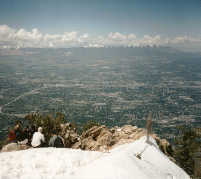
The view (west) from the top of Mt. Olympus
The Mt. Olympus trailhead is not located in Big Cottonwood Canyon. It is located to the north of the mouth of the canyon. If, from the mouth of Big Cottonwood Canyon, you drive north and turn east onto Wasatch Blvd. and follow it as it bends to the north. There is a prominent sign that marks the trailhead parking lot.The trial begins with a steep climb to the top of a popular rock climbing rock. This really gets your heart pumping by climbing about 200 feet elevation in just under 1000 feet distance. After this the trail continues a steady and moderate climb up a series of long switchbacks. I look at the first half of the hike as having 3 sets of switchbacks. The first set begins at the trailhead and ends when the trail bends around a corner and heads into Tolcats Canyon. The second set begins when the trail comes out of Tolcats Canyon and back into view of the Salt Lake Valley where it does a series of shorter switchbacks and ends when it heads back into Tolcats Canyon. At this point you might think you are about to cross the Tolcat Stream (which is usually running from spring to mid-summer) but the trail begins its third set of switchbacks as it once again comes out of Tolcats Canyon and does a few more long switchbacks and ends when it comes back into Tolcats Canyon and finally crosses Tolcat Stream.
The stream-crossing marks the half-way point of the trail at 1.82 miles. It is also a great place to stop for a while. The stream, running under the shade of trees, provides a nice, cool place to rest.
Immediately after the stream-crossing, the trail begins the last 1.88 miles of the trail in a series of about 20 very short switchbacks that climb 600 feet. When the switchbacks finally end, the trail straightens out and begins a steep and continuous climb of 1,400 feet to a saddle which lies a short distance below the summit. You are about half-way between the end of the switchbacks and the saddle when the forest changes from primarily Scrub Oak and Juniper to Pine Trees. At the saddle is another great spot to take a good, solid rest before the final ascent. From here the view of the Salt Lake Valley is partially blocked by forest.* To the east and south, however, there is a wonderful view of the Lone Peak and Twin Peaks Wilderness Areas.
*As a result of a severe wind storm on May 3, 2001 you’ll notice many fallen trees around the saddle. This wind storm had gusts over 100 mph which toppled and snapped 20-40+ large pine trees. In some places on the saddle the trail is now blocked by many of these fallen trees. However, a new path has been clearly established around them.*
The final stretch of the trail is my favorite part. It weaves its way up a rocky scramble climbing about 600 feet in 1/4 a mile. This final scramble does require the use of hands but is suitable for most hikers. It also seems to go by faster because you are using your hands and thinking more about where your next step will be rather than how tired you are. The view from the top of Mt. Olympus is Spectacular. It consists of the entire Salt Lake Valley, much of Utah and Davis Counties to the south and north respectively, and much of the Great Salt Lake.
Be sure to exit the summit at the same place you entered. By leaving another way you might find yourself stuck among cliffs. Just keep your eye open and watch your step.
