
MOTORING HOLIDAY IN NORTH EAST INDIA
By H V KUMAR
H V Kumar and his friends drove all the way from Mumbai to visit the 7 sisters of North East India in November-December 2001 by car. This is their story.
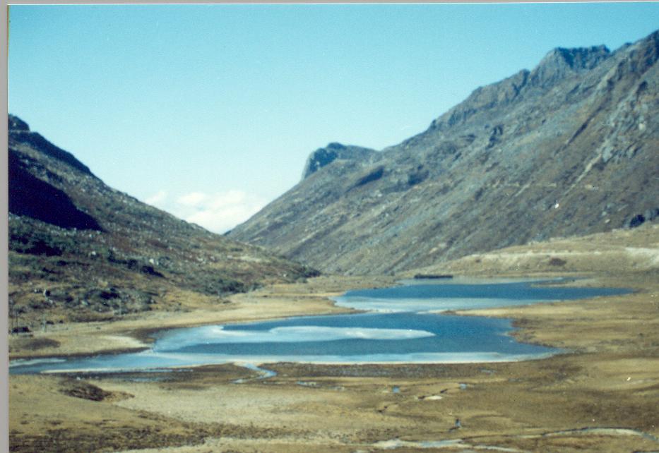
PT Tso Lake, near Tawang, Arunachal Pradesh
Guns. Gun running. Terrorists. Kidnapping. This is what we were told.
Post card sceneries. Exotic destinations. Friends. This is the story we will tell you.
A motoring holiday in North East India in the winter of 2001. Driving down from Mumbai, we covered 15 states and 10,000 kms in 18 days. 2 days driving by night, the remaining 16 days in 16 different places – we never woke up looking at the same ceiling again! Most of the days, we witnessed the glorious sunrises and equally spectacular sunsets. Sounds implausible by Indian motoring standards, but believe me, this was no rally, it was the tourist’s day (or is it days) out!
We were driving a Daewoo Matiz car out of Mumbai. No, we did not head straight out to Kolkata, but we went down to the fertile basins of the River Krishna and Godavari in Andhra Pradesh, via Hyderabad and Vijayawada. Then the drive up the East Coast to seek the blessings of Lord Jagannath at Puri in Orissa. We navigated Kolkata’s Park Street and Chittaranjan Avenue in evening peak hour conditions, a map on the lap and the memories of a visit over 15 years ago.
En route to Siliguri, Bengal is a conveyor belt of paddy fields and we almost mistake the River Ganga at Farakka for the Arabian Sea, so wide and blue that it is flowing through the 100 plus sluice gates to Bangladesh on the other side. You ponder on the meaning of river civilisations.
The gateway to the North East is arguably Siliguri. Go north, and you climb up to Darjeeling and Sikkhim, straight East is the plains of Assam. Startled by our fog lamps perhaps, an elephant charged at us when we were whizzing by the Jaldapara and Buxar wild life sanctuaries. Luckily, we ducked just in time and dodged the grey largeness that lunged at us in the darkness. The Bengal Police dissuaded us from venturing into Assam in the night, and so we held the border post in a resort hotel in the village of Barobisha.
Our arrival in Assam the next day morning was not entirely uneventful – An encounter with a certain "Inspector Rana" unpleasantly reminded us that Assam is being torn between internal conflicts – the Bodos on the North Bank of the River Brahmaputra, the ULFA on the South. Luckily for us, we assuaged his bruised ego. Some more miles down the road, almost on Guwahati, a mob waylaid us and politely extracted "donations" (we did not want to test their behavioral responses when impolite!).
There are only 2 bridges across the River Brahmaputra for almost 700 kms through Assam. We crossed the first one at Saraighat to enter Guwahati that is located on the South bank of the mighty river. Guwahati is a bustling city, basking under the benevolence of the Goddess Kamakhya. Drink in the view of this tempestuous river from the courtyard of the Bhubaneswari Devi temple. Guwahati is the virtual centre of this part of India, and a cosmopolitan mayhem. Our friendly travel agent Jungle Travels had organised our permits in advance saving us a lot of bother and time.
The roads of Assam were superb. Paddy fields and tea estates. They say the best tea in the world grows in the Assam plains. For those of you who have seen tea grown on steep mountainsides in Ooty and the Nilgiris, here it is in undulating terrain. Well populated along the banks of the River Brahmaputra but equally ravaged by it during the monsoons, the river dictates the economy and mood of the state and its people.
If there is one place we wanted to go "once in a life-time", that was Tawang. Arunachal Pradesh – a state hugging the Himalayas, gurgling streams, roaring waterfalls, swirling mists and deep valleys. The progression up the road to Tawang from Tezpur is a lesson, would be a delight for the botanist. From tropical fauna, comprising coconut palms and banana plants, climb the zigzag roads to meet the clouds and under the shade of the lofty conifers, we touch stratospheric heights and travel through desert-like landscapes shorn of trees. We see a new definition of blue in the skies above us, pollution free and pure, but prickly heat from the blazing sun. This is truly one of the few incomparable journeys of the world, if you have the guts for the narrow roads – towering cliffs on one side, abyss on the other. The roads curve round itself again and again ascending rapidly. The Buddhist culture is omnipresent, what with prayer flags, wheels, and the occasional gompa or monastery. The ascents are very steep: remember, we are climbing up from near Mean Sea Level to a height of 13,700 feet, up and down like a roller coaster.

Road to Tawang
Bomdila, the largest town on the road from Tezpur to Tawang, is a one-street town that we cross in under a minute. Don’t be fooled by the fact that Tezpur to Bomdila is only 180 kilometres – instead of the typical 4-hour journey elsewhere, this one takes almost a full day. The next stretch of 180 kilometres takes as much time. We left very early that day at 3 a.m. and traveled from Tezpur to Tawang in the same day. We were well wrapped up to combat the cold of the winter.
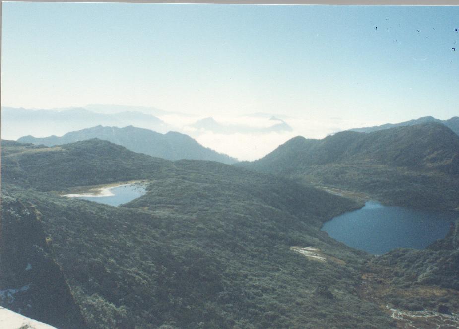
From Bomdila onwards, the villages become even more scattered and the land forbidding. The army has full control over the area and you cross several camps on the way. The highlight of this journey is the Se La Pass – at 13,700 feet lauded as the second highest motorable road in the world. We were already above the cloud line and once there at Se La Pass the car window becomes a virtual aircraft window. The Se La Lake is a sheet of white almost 6 months in a year, but when we first saw this enchanting expanse of blue water, the freeze was setting in. We slid on snow on the road rising away from the suspension Jainath Bridge. The mountains all around were dripping snow to form rapids and cascading streams of water.
Se La Lake
Tawang is at a height of about 3500 metres and bitter cold. Buddhism radiates all around. Don’t be disappointed that Tawang is not the usual type of tourist destination. No parks, no fancy eateries, no shopping malls. The Tawang Monastery is one of the largest in this part of the world, and headquarters of one of the sects of Buddhism. The huge prayer hall has a statue of Buddha that is a few stories high, and richly decorated with tapestries, thankas and carvings. We are very close to the China border: in fact, during the 1962 war, both Tawang and Bomdila were annexed by the Chinese armed forces. Most interestingly, we are as close to Beijing as we are to Mumbai – over 4,000 kilometres! On the way to Bum La that is the border, we cross the P T Tso Lake and the Takstsang Gompa, one of the oldest Buddhist monasteries in the region.
PT Tso Lake
We are back to the plains of Assam, cruising along the South bank of the River Brahmaputra. Our next port of call: the Kaziranga National Park, the home to the one-horned Indian Rhinocerous. The jeep safari on the dirt track that is rebuilt every year after the earlier one is washed away by the floods is very scenic. A treasure trove of wild life – various species of deer, innumerable birds, otters, etc. The tall elephant grass is home to the Rhinos, 15 of who were sighted during the couple of hours that we took the tour. Beyond the vast grasslands was thick forestland where the most important inhabitant is the Elephant.

Rhino at Kaziranga
The River Brahmaputra dominates the landscape. Jorhat, one of the largest towns in Assam, is on the banks of the river. At Nimati Ghat, the ferry crosses the 10-odd kilometres with of the river to reach Majuli, which is considered to be the largest River Island in the world.
After Arunachal and Assam, now it was time for us to pay our respects to the others in the family of 7 sisters. Nagaland was hosting the Great Hornbill Festival when we drove into Kohima, the capital city. Kohima has a lot of history – this town resisted the advance of the Japanese forces during the World War II. The War Memorial pays homage to the thousands of soldiers, both British and Indian, who fought for British India. Kohima is a nondescript town otherwise and not very well endowed in tourism infrastructure.
This is total bamboo country. Hills and hills covered with bamboo trees. Houses made of bamboo. Bamboo shoots for breakfast, lunch and dinner. Handicrafts made of bamboo. Bridges of bamboo across streams.
From Kohima to Imphal and the state of Manipur. Recent insurgencies in Nagaland have been tough on the Manipuris since their only all-weather road to the rest of India was often blockaded by pro-Naga terrorists. The beauty of the countryside keeps you awake. Terraced rice fields in the wide valleys surrounded by hills. Near the town of Karong, we travel through a valley bursting with the yellow of sunflowers.

Karong, Manipur
Manipur is an ancient kingdom mentioned in the Mahabharata. It is said that Arjun was betrothed to the daughter of the king of Manipur. The Keibul Lamjao National Park early in the morning has a mystic atmosphere, with the mist snaking down to the waters of the Loktak Lake. The Sangai deer is so small, some not larger than a dog and we strain our eyes to sight them grazing in the marshy grasslands. The nearby town of Moirang witnessed history when Netaji Subhash Chandra Bose hoisted the Indian tricolour for the first time when the Indian National Army swept across the Burmese forests to shake the British Raj at its foundations. The international border is not far away, and the shops are stocked with not Nirma and Amul chocolates, but with velvet blankets from China and groceries from Thailand.
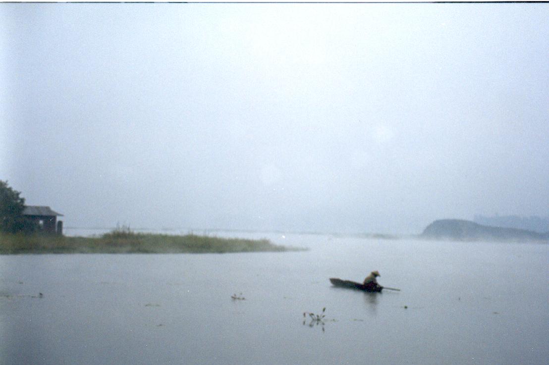
Loktak Lake, Manipur
Now was to come the worst or rather most adventurous part of the trip. There are 3 ways to get to Silchar, which is in the southern part of Assam from Imphal. Fly Indian Airlines. Take the long road via Kohima and Hafflong. We took the third: NH 53 direct to Silchar. What masquerades, as NH 53 is a dirt track that does not see any vehicle on most days. Probably closed completely during the rainy season. "Gun-runners" highway, which is what it, is called locally. But let me tell you that it is one of the most scenic highways I have ever traveled in India. The 2 army checkpoints were astounded at our audacity to ask to go through that road. On being asked for advice, they took the line from the Hindi movie Border, "Marega ya marenga" (Assault or die)! They told us that people are not just kidnapped, they are also scalped for no rhyme or reason whatsoever. Well, the condition the road is in, even the terrorists will find it difficult to lurch towards us, and the road is so full of craters and mountain-high in muck. We virtually lifted and carried our car in places, and speeded by the 150 odd treacherous portion in something like 8 hours – crawling at less than 20 kph. On a more serious vein, this countryside is the favourite camping ground for several terrorist groups and their smuggling route for arms from Burma and other places from where arms are supposed to come from. Bamboo jungles surround us all the way. Whew, we reached the other end at Jiribam to be detained by the Manipur border police who suspected us of being gunrunners ourselves. An hour of questioning later, they shook their heads in disbelief and congratulated us for coming out of it alive. The Assam side of the border was no better – police checking twice and apparently bandit-infested country. We were rather happy that we had taken the precaution of hiding our cash and valuables in at least 4 different places in the car!
Silchar, a night later and after wrestling with the Mizo authorities for permits to visit their capital city, we were in Aizwal in the Mizo hills. This city vibrates even at midnight unlike the rest of the region that goes to bed by 8 p.m. They say that the fires of the insurgency movements of the past still burn, but we probably got the best hotel rooms of the trip here and met hospitable people. Although the state is steeped in cultural tradition and rich cultural heritage, we had too little time in this touch-and-go trip, but yet managed to soak in the ambience of this hilly state and resolved that this is one town we must visit again. The state is so far-flung, exotic and picturesque that even a weeklong holiday out of Aizwal may be found wanting. The warm Madrasi family who we befriended told us that we were the first tourist visitors to the home they have lived in Mizoram’s capital since 1984!
Now it was the turn of Meghalaya, the land of clouds. Believe me, the sun did not spy out even once, it was so overcast and cool the whole day we were there deserving the sobriquet. Long the capital city of the whole North Eastern region, Shillong is a typical British contonment town, built on the lines of Shimla. Parks, waterfalls, statues and lots of hotels. But we had our sights zoomed in on that charming place from our school geography lessons – Cherapunjee. Not for us Mynsram which has wickedly usurped the title as the rainiest place in the world. Take a sample – in Mumbai, it rains 3000 mm annually, Cherapunjee gets 12000 mm. One day in 1977, it rained nearly 3000 mm here in 24 hours! Alas, it did not rain while we were there but the mighty waterfalls of Nokhalikai at Cherapunjee Point peeping through the constant fog assuaged our spirits somewhat. Somewhere way below the rock cliffs are the plains of Bangladesh and another world altogether.

Cherapunjee
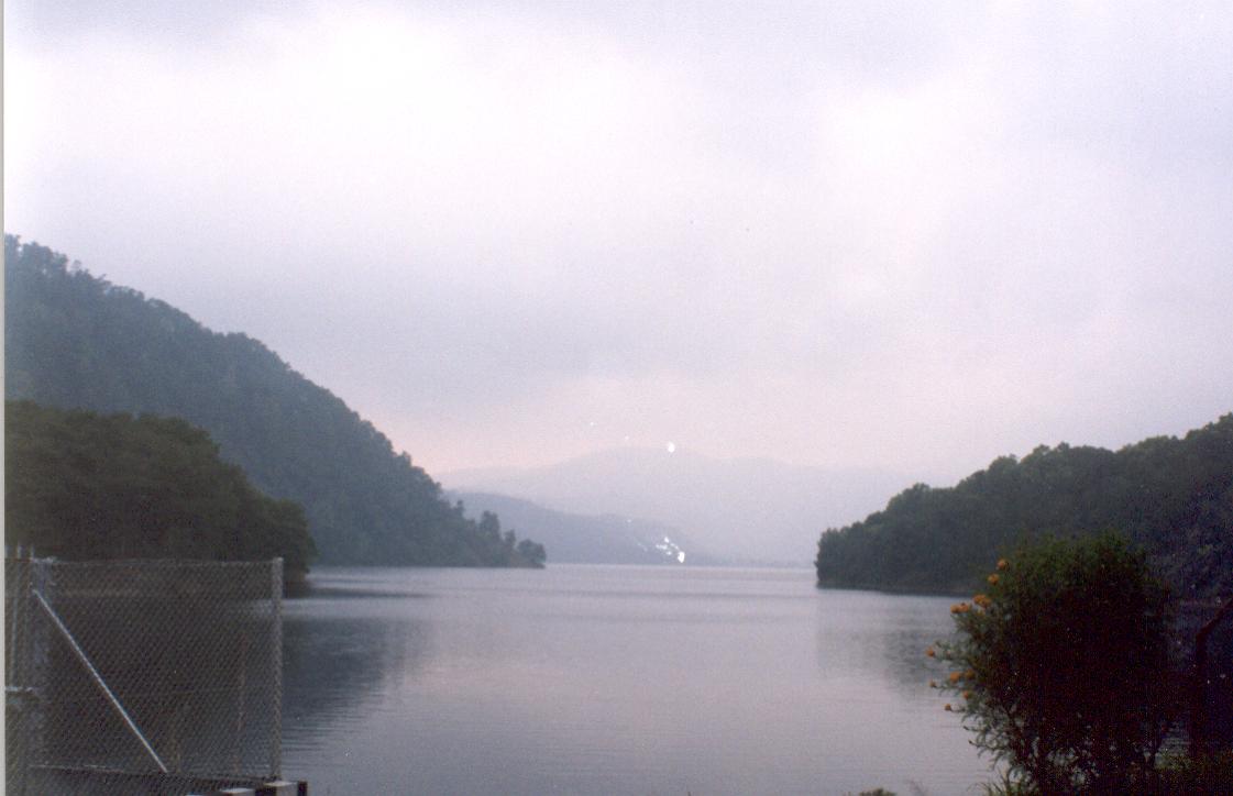
The best was yet to come on the way back to Guwahati from Shillong. The spectacle of the Umiam Lake took our breath away, it could keep a professional photographer busy a full week, and more perhaps.
For the first time when we drove out of the North East region that night, we felt scared at the eeriness of the lonely country side that is totally desolate after 8 p.m. To drive home the disappointment of Cherapunjee, it rained cats and dogs that night in Assam. Back to Bengal, we had a torrid time at midnight crossing a biggish river (what happened to the original bridge – blown up?) on what was a mix between a footbridge and a footbridge – certainly made of bamboo! Heavier vehicles swam across! We survived the night and narrowly missed sunrise at Tiger Hill in Darjeeling. This Queen of the Hills wore a wet saree and left us cold, but the Fairy Queen chugs on as it has done for over a century. We were all travel-weary and ready to hit the road back home – only 3,000 kms, that is!!
Starting from Darjeeling, we had a dream run back home. The first day, we whizzed past the fields of Bengal, Kolkata and halted at Kharagpur overnight. Fearing bandits in the Bengal-Bihar border, we woke up and left late (i.e. 500 a.m.) and ended up at Raipur by 900 p.m. The River Mahanadi was no mean sight at both Hirakud Dam as well as Baragarh. But the wilderness and poverty in this part of Orissa touched our hearts. The garage mechanics who spend 3 hours repairing our car said it was free because he could not solve our problem. The day was miserably hot and served a reminder that Orissa has real hot summers……and hot winters too. The last day of the trip saw us beating the Howrah-Mumbai Gitanjali Express from Raipur to Mumbai – we did 1,200 kms that day from 300 a.m. to 900 p.m., through Chattisgarh and the entire width of Maharastra from Nagpur to Mumbai.