FROM UNIVERSAL PRESS SYNDICATE FOR RELEASE: WEEK OF SEPTEMBER 25, 1998 COLUMN OF THE AMERICAS by Patrisia Gonzales and Roberto Rodriguez 1847 MAP ENDS IMMIGRATION DEBATE
Our recent column in which we revealed the existence of the 1847 Disturnell Map, the official map of the Treaty of Guadalupe-Hidalgo, has riggered an avalanche of letters from hundreds of readers in every corner of the country. The map, which is housed in the National Archives in Washington, D.C., indisputably shows a site -- "Antigua Residencia de los Aztecas," or Ancient Homeland of the Aztecs -- somewhere in the Four Corners region of the U.S. Southwest.
During a recent trip up the Colorado River, we found that the site is not in northern Arizona (as we originally wrote), but in Utah. The map shows that the ancient homeland is north of an area called "Apacheria" near the "Nacion Navajoa" and also the land of the "Moquis" -- the name given to the Hopis by the Spaniards. Many of the original place names were first changed by Spaniards, then subsequently by the U.S. government after the 1846-48 war against Mexico.
This map incontrovertibly proves that rather than being foreigners, Mexicans (and Central Americans, who were also Nahuatl-speaking peoples) are indigenous to Arizona, New Mexico, Colorado and Utah. It also corroborates the oral traditions of Hopi, Pueblo and Lakota Indian elders -- that Nahuatl-speaking peoples are their relatives.
One reader who is familiar with the area, Esteban Diaz of San Bernardino, Calif., wrote: "My grandfather was born in that area of Apacheria (he was Apache), and he would always tells us that this was our land. Clearly he was right." To us, it's as if the map has lifted an oppressive aura of "suspicion" from the psyche of Mexicans/Central Americans -- populations that have been deemed to be illegitimate by some in U.S. society. Another reader, Anita Quintanilla in Berkeley, Calif., wrote: "I would like a copy of the map to display in a prominent place for the whole world to see!" Some readers are speaking of putting the map up as a billboard along the U.S./Mexican border that proclaims "Welcome to Your Ancestral Homeland."
The "Antigua Residencia" site also corresponds to the general location that Cecilio Orozco, a professor of education at California State University at Fresno, has long contended is the "Aztec" point of departure on their southward migration. He argues that the migration story of Mexican people was never a myth. In fact, he has located the point of departure in Utah and, more generally, the Four Corners region. This area, he said, was called -- "the old, old colorful land." He has published two books on the subject, "The Book of the Sun, Tonatiuh" (self-published) and "Las Letras del Licenciado Alfonso Rivas Salmon" (Marin Publications).
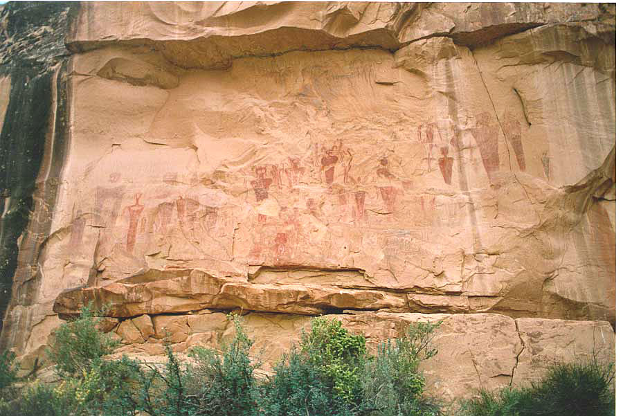
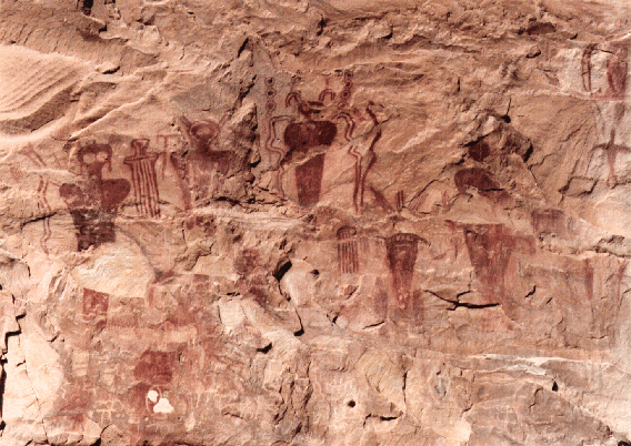
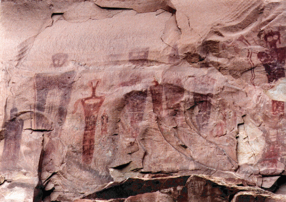
The actual name of the people who lived in Tenochtitlan (present day Mexico City), when the Spaniards arrived there in 1519, was Mexica (pronounced Meshica). Several hundred years earlier, one of the migrating tribes had been called Aztecs, and the original name of their migrating descendants were the Nahuatl (people of the four rivers), said Orozco. He's found evidence of a glyph in Sego Canyon, Utah, from 500 B.C., which he said corresponds to the "Book of Tonatiuh," also known as the Aztec calendar.
Orozco said he came upon the site through a process called "archeo-astronomy." He saw a photograph of four rivers in Utah in 1980, and based on previous research, recognized a mathematical formula in the photo that led him to believe that this was the place of origin of the Mexicas' ancestors. Subsequent trips and research has confirmed his thesis, he said, adding that there are at least 2,500 archeological sites in the area.
The moral argument used against Mexicans in the immigration debate -- that they are invading aliens -- has been rendered completely baseless by Orozco's research and the map. It ends the debate. He related that he spends lots of time presenting this information to children so that they know that "our roots are absolutely here in the United States." Mitch Garcia, a reader from Colorado, wrote that when he's told to go back to where he came from, his mind travels to Saguache, Colo., and a bit farther to northern New Mexico, homelands to at least five generations of his family: "This is information that was not documented in a book, but rather in our hearts by mama and papa and their mamas and papas. I then come back to the present and realize I'm really not that far from 'home.'" No child should ever be made to feel like an alien anywhere in the world. This map, to the chagrin of xenophobes, moves our society in a better direction.
COPYRIGHT 1998 UNIVERSAL PRESS SYNDICATE * Both writers are authors of Gonzales/Rodriguez: Uncut & Uncensored (ISBN 0-918520-22-3 UC Berkeley, Ethnic Studies Library, Publications Unit. Rodriguez is the author of Justice: A Question of Race (Cloth ISBN 0-927534-69-X paper ISBN 0-927534-68-1 Bilingual Review Press) and the antibook, The X in La Raza and Codex Tamuanchan: On Becoming Human. They can be reached at PO BOX 7905, Albq NM 87194-7905, 505-242-7282 or XColumn@aol.com Gonzales's direct line is 505-248-0092 or PatiGonzaJ@aol.com ------------------------------------------------ * Professor Cecilio Orozco can be reached directly at: cecilioo@csufresno.edu Or you can visit his website at: http://www.inconnect.com/~rvazquez/sunstone.html * Copies of the map in color can currently be obtained at two locations. Contact them by e-mail or call them for details: