Jo had an interest in things celtic and mystical and when she told me about 'ley-lines' the cynic in me decided to determine for myself whether there was anything in it.
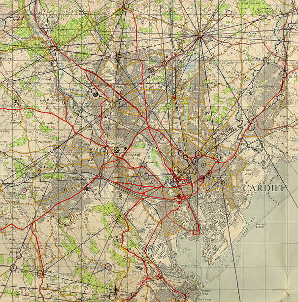
I bought two OS (1966, 1" series) maps and proceeded to plot ancient sites on one map and modern artefacts on the other (pubs, post offices, hospitals and railway bridges). The map noting modern artefacts was ruined, the other was not, as you can see.
Lisvane church figures predominantly with at least ten alignments passing through it. The Butetown-Roath-Lisvane-Rudry-Twyn Tudur alignment appears to deviate 31.6" E from True North. Can anyone supply a date as to when this line might have represented True North (tectonic drift?)?Similar alignments can be found elsewhere in the UK, eg;
although it can be implied that many of these date from the christian era, for example;
Flood defence and avenue (19th cent?) aligned on Llandaff cathedral.However, the origin of these appears to rest with cultures predating, or contemporary with, the megalithic period. What struck the author as important was that some intersections occured some miles out into the Severn estuary. Papal edicts decreed that, in order to get the pagans into the churches, they be built on pagan sites. Apart from those near sacred yew trees, these often stood in prominent sites with a readily available source of building material, such as stone, eg;
These dolmen types were originally covered with a mound of earth which has since been eroded away, and are usually associated with use as tombs, this one (Pentre Ifan) being contemporary to the later construction phase at Stonehenge.An interestingly large cairn can be found locally at ST092733, west of Tinkinswood. This has a roof composed of a single stone some 40 tons in weight, averaging 2' in thickness (indicating, by the effort required to move it, that this was a site of some significance). From my own point of view the major point of interest here is that the tomb was closed with a stone which at one time, I believe, was horizontal. The outer face of this is rough hewn but the side presented to the tomb interior is deeply scored and weathered to a relatively smooth finish. One is reminded of fertility rites involving human sacrifice and perhaps this stone was used for the dismemberment of the sacrificial victim. It's 'new' use as a stopper for the tomb may indicate the discontinuance of the older religion, it's scored surface then being denied (to adherents of the former religion) it's former use. Oriented to the east (approximately 76 degrees from N), and thus the sunrise.
Smaller cairns situated within walking distance to the south and east probably date from the same period, and to the north, on the Garth mountain, three more command a pretty stupendous view of the surrounding countryside. As time permits I'll take some photos and angular measurements to be included here.
Stonehenge, which Tinkinswood appears to pre-date, took on it's 'stone' attributes with the arrival of the first from Wales. The site being deemed sacred for some considerable time, the first phase (3000-2920 BC) consisted of a circular ditch and bank (the henge). The second, timber uprights, the third, the bluestones (about 2600 BC from Preseli) and the fourth, the sarsons (2500-2000 BC) when the open pasture around the site became intensively farmed (also contemporary with much tomb-building in the Scilly Isles and the activity in the Preseli Mountains from which the bluestones came, perhaps as an already extant circle?). Three large postholes (in the current car-park) must be taken into account when considering the earliest layout, the mid-winter sunset being thought to be most important, as at Newgrange. If an influx from Portugal/Spain is possible, a landing is likelier to have been nearer Carn Meini, than Wiltshire. The similarity, in that a bluestone ring exists also there, but nowhere else, could be an honour to ancestors whose people did well, the Welsh ring being thought older, The timber uprights could hint at a temporary roofed space, this being useful for a mid-winter festival.
Standing within the stones, as at Avebury, it seemed natural to negotiate the gaps between them, some of which are so narrow that only a small child could pass through. At the time, and now still, it is felt that the sizing of the gaps of the stones at Stonehenge was as important as the placement of the stones themselves. It, I believe, can be seen that winding ritual dances or movement were integral with these structures and each stone had it's own identity. One can speculate that each may even had had it's own nominated 'dancer/s' or even that the horizontal stones supported by the sarsons had 'runners'. Think of these carrying torches at night, then consider how many people could surround the 'monument' and how far it could be seen.A 'stonesthrow' ENE from Stonehenge are Durrington Walls dating to 2500 BC. Here a 16m wide ditch, 6m deep, was surrounded by a 3m high bank of chalk over a distance of a mile. Two wood 'circles' have been found inside the circle (one 'reconstructed') together with the only Neolithic road found in Europe, leading straight to the River Avon, a similar arrangement to that found at Stonehenge, downstream (it should be noted that there are two rivers in the area, so named). Alignments at Durrington suggest a mid-winter significance and middens point to much social activity possibly at this time.
The river might well have played a part in ritual linking the two sites. If the stones represent the ancestors, and wood the living, a journey between the two might signify a transition between them. Water was the most magical medium and this trip would have been taken through islets covered in reeds and willows. Perhaps there were stages, and even oracles.
The arrow-pierced occupant of the burial found near the entrance of Stonehenge begs comparison to the rich contemporary burial to the east. One wonders if they were related; the wayward son of the respected man perhaps having gone too far, hunted and killed like the pigs at Durrington. Perhaps we now know the time of year he was shot down.
Some 210 miles almost due north is Thornborough, N Yorks (SE2979) at the same age (5000 years old) which has 3 henges faced with gypsum with a ditch inside and out, the banks broken by a path through the centre of the henges. The layout resembles Orion's belt, Orion rising above the central path (viewed from N) about mid-Aug (at time of construction). The flatness of the land to the east of Thornborough might have had mid-winter significance. Stonehenge, Durrington and other similar sites, it is felt, supported similar events at similar times of the year.
Once surveyed, henge creation could have become a sport, with competing tribes, families and clans vying for the most prestigious demonstration of resource, power, etc, in creating them, perhaps as some rich christians used to think that by building a bigger church a more direct ascent to heaven was achieved. It required large numbers of people to dig the henges, but even the little ones could gather some stones. Multiply this by a couple of hundred, or thousand, and over a few years structures on such a scale become feasible, especially if an obligation is added.
Many ancient sites appear to be designed to accommodate large crowds who, obviously, are expected at the same time of year. With the renewal of the solar year, the mid-winter solstice, the significance has been carried down even to today, Mithras having being superceded by the Roman Christ, for example.
The areas within the henges are considered to be archaeologically clean compared to the surrounding area. At Durrington even dog waste is swept into pits outside. Quite a party, huh? But well organised and ready for next year.
For an interesting insight into earlier religions I would recommend to the reader the work of Robert Graves, especially 'The White Goddess', 'The Greek Myths' and the Larousse 'Encyclopedia of Mythology'. One must also bear in mind the considerable amount of archaeology that has yet to be considered, let alone done, on the continental shelves.
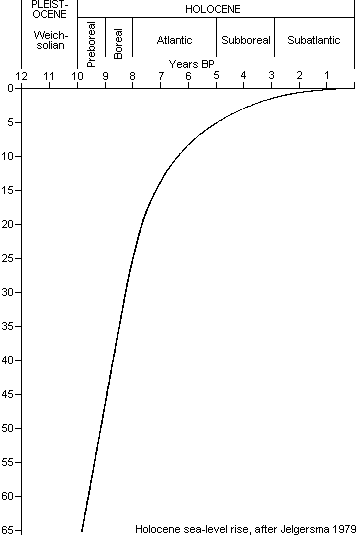
It has been recognised since the early 20th century that archaeological remains of prehistoric human habitation are also present on the sea-bed, which contains sediments dating from throughout the last 500,000 years and much of which has only been submerged for the last 5,000 when sea-level climbed to within 10–12m of its current height.


At the end of the last Ice Age the water level was probably 400 feet lower than it is today. The entrance to the ancient art gallery, including penguins, discovered in a cove near Cap Morgiou, near Marseilles, dated to some 18-20,000 years ago and thus several thousand years older than those of Lascaux, is some 121' (37m) below sea-level. The areas known now as the North Sea, English Channel, Irish Sea, St George's Channel and the Severn Estuary may well have been forest and grassland with large freshwater lakes teeming with wildlife.
Middle Palaeolithic peoples demonstrate the earliest undisputed evidence for art and other expressions of abstract thought such as intentional burial of the dead. Domestication of the dog as a hunting companion probably dates to the Mesolithic, or Epipalaeolithic.
Link to 'Arthurian' chronology.Perhaps the decline in sea-level rises was apparent through oral tradition. After all, with rises averaging an inch a year, distinct changes would have been evident in a single lifespan, let alone a tribe's. Is it coincidence that megalithic cultures arise 'on the turn' as it were? Or were extant structures, already lost, being recreated? Are there connections with world-wide legends of a 'deluge'? Interestingly, coastlines, around which many human societies settle, are not as stable as one may think, eg;

Notwithstanding sea-level fluctuations, like those above, land masses free of the weight of ice can rise as in the case of Norway, which is still doing so today. A cave on the west coast of Scotland, once at sea-level, is now 100' (30m) above it. A so-called "structure", 600 feet long and 90 feet high, said to be about 10,000 years old, thus obviously predating the edifices of the ancient Egyptians and Babylonians, is now under about 75 feet of ocean near a small island named Yonaguni southwest of Okinawa. The main argument that the object has not been manufactured by nature, is that if that had been the case, one would expect debris from erosion to have collected around the site, but there is none. Experienced divers express the view that so many 'natural' features could not be expected to congregate in such close proximity to each other. What appears to be a road surrounding the building has been cited as further evidence that the structure was made by humans, together with smaller underwater stone mounds and objects nearby. Like the main structure, these are made of stepped slabs and are roughly 10m wide and 2m high.
The thought of a predominantly agricultural society producing a food surplus sufficient to enable it's members to engage in the long-term art of arranging very large stones may not seem so strange considering the present day occupation with a roughly round object that is thrown or kicked. For rapid progress the weather would have had to be fine and dry. It has been suggested that the beaker people's beakers contained a cannabis beverage, probably alcoholic, whose recipe swept Europe, thus resulting in a fashion for this particular implement. Doubtless, other combinations were freely tried. It certainly would have been a sight, with the teams' supporters singing and chanting. Just like today. Then there would have been the years of tales that went with it. An attractive proposal, put forward by Graves, as to how the stones were moved over some sections involves a set of shear-legs surmounted by a tribe's totem symbol, giving rise to a legend of giants moving them.
Proportionately speaking, what could be achieved today with such resources?
sonics | Tinkinswood | Preseli Hills | Pentre Ifan | harvest | ghosts