
Detachment #1, 305th Flight Control Squadron of the US Army Air Corp began radar operations on the island of Ie Shima, just west of the Motobu Peninsula of Okinawa, in mid-1945. The tiny island, captured early during the invasion of Okinawa, had an airfield that supported American fighter aircraft operations. The Detachment was emplaced there in support of those operations.
By September 1945, the parent unit, the 305th Flight Control Squadron, had arrived from Hawaii and it was tasked to establish radar operations on Yontan (Yomitan) mountain, a 220 meter peak a few miles north of Kadena Air Base overlooking Yontan (Yomitan) Airfield, Okinawa. By then, Yomitan was also an operational Army Air Corp airfield. The terms Yontan and Yomitan are the same name. Yontan being in the local dialect and Yomitan being more precisely Japanese. Exactly how long the unit remained on Ie is not known, however, by 1946 they had relocated to a SeaBee Camp called "Camp Makibaru". Read about the establishment of the camp in the document called "Was Bishigawa Makibaru?"
The camp, located in a triangle formed by the confluence of two streams, was re-named Bishigawa after the Bisha "gawa" or Bisha "river" that was formed by the two streams. The Bishagawa flowed westward from there into the East China Sea. The name is also written as "Bishigawa". Bishi - Bisha - tomaytoe - tomahtoe!
That river flowing into the sea is formed by a north fork flowing south from the interior of central Okinawa, and a south fork which flows in a more southwesterly course from the interior of central Okinawa. The south fork was the major stream year-round, but during periods of heavy rain, both streams became torrents, flooding and closing unimproved roads. Modern reservoirs reduce that hazard today.
Old maps show the seaward flowing river as the Bishagawa, while modern maps show it as the Hijagawa. Old photograph captions and modern maps both describe the southern fork as the Hijagawa. An area, similar to a district or division, just north of the river is called "Hija". The Japanese character for Hija is nearly the same as the one used for Bija. 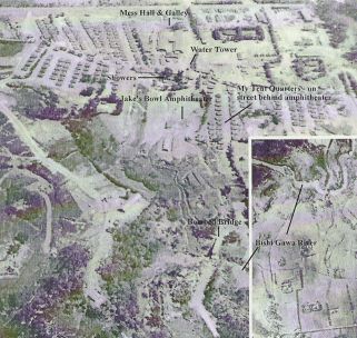 The only difference being the addition of two tiny dots that changes the enunciation from Hija to Bija. Hisha and Bisha are another way they may be written in our Roman characters as the "sha" and "ja" sounds are very similar. I am told that the only difference in the name of the river is to be found in our translation of the Japanese and that Hija is the most correct. The term "Bishi" is undoubtedly a G.I. corruption of the word Bisha. Something G.I.'s have been quite famous for. So, for our purpses, Bishi, Bisha, and Hija are all interchangeable and the south fork was the Bishagawa. No maps found identify the north fork.
The men who were at Camp Bishagawa refer to the "River" without specifying which (north or south fork). They speak of their hut "backing up against the river", bluffs "overlooking the river", the roads being "closed by the river" and "swimming in the river" without specifying the location of the river or identifying it on a map. No maps, outlines or "sketches" of the Camp Bishagawa layout have been found. Using the aerial photograph of the camp that was taken in 1945, a map or ooutline of the camp could be const5ucted.
In July 1946, the 305th Flight Control Squadron became the 623rd Aircraft Control and Warning Squadron, still providing air control and defense for Okinawa from Yontan Mountain.
The original Camp Bishagiwa consisted of tent billets and a few huts for assorted activities. Quonset hut construction was begun in 1946 and within a period of time replaced all the canvas/wood structures. Facilities were built not only to house the personnel. Headquarters and staff offices, chapel, dispensary, dining hall, supply and maintenance facilities, water towers, recreation buildings, Post Exchange and even an outdoor stage/movie theater, were all constructed. Facilities with names like "Comet" and "Buzz-In" would go up over the next few years (and some came down during the ferocious typhoons that regularly lashed Okinawa). In September 1947 the Army Air Corp became the US Air Force and our comrades at Camp Bishagiwa hardly flinched. If other units shared Camp Bishigawa with the 623rd ACW, that information is not yet forthcoming.
In the spring of 1948, the 623rd ACW Sq was joined at Camp Bishigawa by another ACW Squadron, the 624th. With this growth came a new ACW command for both Squadrons, the 529th ACW Group, which was headquartered at the Camp. Camp Bishigawa was expanding, as were USAF radar operations on Okinawa. Over the next 3 years new radar sites were established up and down the Ryukyu Island chain and another ACW Squadron, the 851st, was formed as were Detachments for the off-island radars stations. These were the heydays for the Camp. For pictures and information, visit the 623rd ACW Assn website www.angelfire.com/pe/623ACW and click on the "Bishigawa" line at the bottom of that home page.
But things change and so it went for Camp Bishagawa. In 1952 the 529th ACW Group Hq, along with the 851st ACW Squadron relocated to Naha Air Base south of Kadena Air Base. In July 1956 the 624th ACW Sq relocated to it's radar site on the Motobu Peninsula and the 623rd ACW began to relocate to it's radar site at Yozadake in southern Okinawa. The 623rd ACW Squadron officially relocated in Aug 1956, leaving Camp Bishagawa forever!
What became of Camp Bishagawa between then and 1958 remains to be learned. But it is known that the USMC used the camp for training purposes as early as 1958 and were, in fact, well established there by then. The 3rd Battalion, 3rd Regiment, 3rd Marine Division had an entrance sign that read " Camp Bishagawa" alongside a USAF unit sign that read, "Headquarters Area - Okinawa Airmunitions Depot - 546th Ammunition Supply Squadron". Did they share Camp Bishagawa with the USMC, or did they only share a common access road? The Marines used the existing Quonset buildings and facilities until at least 1960/61. To see photographs of the camp during 1958/59 and read more about it, visit a former Bishagawa Marine's website www.bobrohrer.com and click on "Okinawa".
Sometime after the USMC departed camp Bishigawa it became a US Army facility. This had to have been before June 1962.
By June 1962 the US Army 1st Special Forces Group had moved into the camp. It was later officially named Camp Dominick Sansone, in honor of a 1st SFG Green Beret "KIA/Body Not Recovered" in Viet Nam in December 1964. One article about SFC Sansone can be found on the internet at http://www.pownetwork.org/bios/v/v350.htm
Either before the 1st SFG occupied the camp, or at some point after, the Army's 808th EAB (Engineers) demolished the old camp, leveling all of the nearly 20 year old "temporary" buildings. They performed major excavations to prepare the location for its future use. This included removal of many slopes, grading, performing land fills and preparing a foundation for, what appears to be, a very short (helicopter?) runway. It appears that they also constructed at least 4 permanent, single story, buildings.
The 1st SFG were said to still be at Camp Sansone in July 1968, which may or may not be correct. Additional information should be forthcoming from the many 1st SFG veterans available on line. Also, the 808th EAB is part of a large Army Engineer Association and more information about the demolition and re-construction of Camp Bishigawa may one day become available.
Bill Choate, a 623 ACW Sq Bishigawa veteran from 1946 -47, said that he worked on Okinawa in 1966 and lived across Highway 1 from Bishigawa in a CIA compound called Morgan Manor (not to be confused with the civilian owned housing area by the same name in the same area). In a 2004 letter he said that he had visited his old camp location in 1966 and found it vacant and abandoned and that only crumbling foundations remained.
In an attempt to learn more about the fate of Camp Bishigawa, I visited the site in 2002, but was unable to gain access. I was able to photograph some locations that had been photographed in the 1950's (gates, bridges, access roads, etc.) outside the camp and to correlate the two. I visited with the Installation Engineers at Kadena Air Base to review maps and to learn about current occupants of the site. Although the location is now essentially a part of the huge USAF ammunition storage facility, a Restricted Area, there are two major units not affiliated with ordnance at the old camp location. They are the PACAF-wide sentry dog (K9) training facility and a USAF Engineer unit Detachment that uses the facility for temporary flightline construction and maintenance training. I also confirmed that Yontan Mountain, the old radar site, had been handed over to the US army in the early sixties and had become Hawk Missile Site 10 in 1961. I had occasion to visit Site 10 during the years 1965-1967 when I was assigned to the major Army Air Defense Command on Okinawa. At the time, I did not know that it had once been a USAF radar site. It was very interesting to learn on this visit that the old Site 10 remains a Japanese Self Defense Force Air Defense missile unit, and has a modern civilian golf course for a neighbor up there on Radar Hill! Some of those 2002 pictures can be seen on Bob Rohrer's USMC website.
Returning in 2004, I was more fortunate and was granted escorted limited access to the Kadena ammunition storage area to visit the old Camp Bishagawa site. Nothing remains of the old Camp Bishigawa, not even a concrete foundation! I was allowed to photograph the old camp location. The permanent buildings described to me by Vets from the 1st SFG appear to remain intact, with the addition of a few other buildings. The short runway dominates the site and there is a large hanger-like building at the east end of it. I photographed the entire area as it appeared. Bishagawa veterans will be able to recognize some of the terrain features, like the athletic field area, elevated slope where the headquarters and flagpole stood and possibly even some of the trees. I have found that many old trees still stand around Okinawa and their branch formations form a signature that says "I'm bigger, but it's me"! Again, those pictures and a professionally blended panorama constructed from my series of pictures are on Bob Rohrer's web site.
The JSDF missile site is still up on "Radar Hill" and there is Radome tower up there that is visible from below the site from Ishikawa on the east side of Okinawa and from several points along the west coastline.
I hope that this report will satisfy the "whatever happened to?" questions many Bishigawa veterans have had over the years. You will always have your memories of adventures and comrades to share. But did you know that there is another thing that will always be with you and which you can be sure of ? In spite of all the changes you've read about here, if you can remember the clear skies full of sunsets, sunrises, stars, moon and scudding clouds; the wood smoke lingering over the valleys, the smell of the sea air, the cooling breezes and the hush of dawns on the mountain, it will all still belong to you, for all of that all remains today, just as you left it. It remains because you were a part of it.
Things Yet to be Learned About Camp Bishigawa
1. Names of other units that occupied the camp with the 623rd ACW.
2. Maps, sketches, outlines of the camp and its surroundings.
3. Strip map of the road into camp and up to Yontan Mountain.
4. Map, sketch, outline of radar site on Yontan Mountain.
5. Date the USMC 3/3 occupied the camp.
6. Date they departed the camp.
7. Date the 808th EAB demolished the camp.
8. Date new permanent buildings were constructed.
9. Date the 1st SFG occupied the camp.
10. Date they departed the camp.
Old Camp Bishigawa, Okinawa
ddl 7/27/04
Edited and posted to the 623rd site by J London, Feburary 2005. [KG]