|
|
International Scale of River Difficulty
The classes below are the American version of the rating system used throughout the world. This system is not exact. Rivers do not always fit easily into one category and there may be regional interpretations. This information is from American Whitewater.
Class I: Easy - Fast moving water with riffles and small waves. Few obstructions, all obvious and easily missed with little training. Self-rescue is easy.
Class II: Novice - Straightforward rapids with wide, clear channels which are evident without scouting. Occasional maneuvering may be required, but rocks and medium-sized waves are easily missed by trained paddlers.
Class III: Intermediate - Rapids with moderate, irregular waves which may be difficult to avoid and which can swamp an open canoe. Complex maneuvers in fast current and good boat control in tight passages or around ledges is often required. Strong eddies and powerful current effects can occur.
Class IV: Advanced - Intense, powerful but predictable rapids requiring precise boat handling in turbulent water. May be large, unavoidable waves and holes or constricted passages demanding fast maneuvers under pressure. Rapids require �must� moves above dangerous hazards. Self-rescue is difficult.
|
Paddling The Tuna Creek
(also know as the TUNUNGWANT)
All photos on this page are click-able to view larger images
|
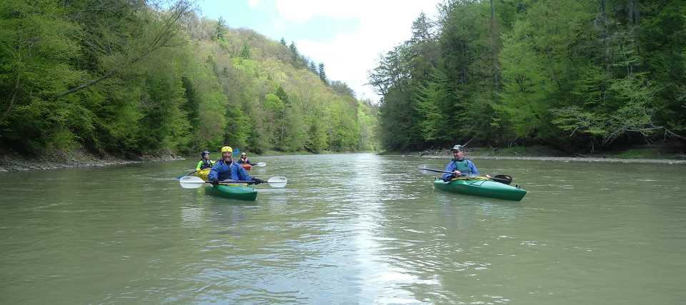
Tuna creek- Section One:
This is a trip on the Tuna Creek (also know as the TUNUNGWANT), from Bradford Pa. to Limestone NY.
This is a fairly slow, meandering creek (or river). It's perfect for canoes as well as kayaks, or even inflatables.
there is at least one real nice deep sand "beach" along the way (a prominent sand bar).
The launch is at Bolivar Drive in Bradford, Just off the Foster Brook exit on 219. This is the first exit on 219 for Bradford if you are coming from the north (Rt 86/17). It's normally a 1 1/2 to 2 hour trip down to "Rockin' Rick's" in Limestone. It's 3.91 miles in the creek (by boat). We pull out where the Tuna crosses Limestone Run Road.
You can print out the full sized version of the first map below. It shows the creek trip, the start/finish, and the nearby roads.
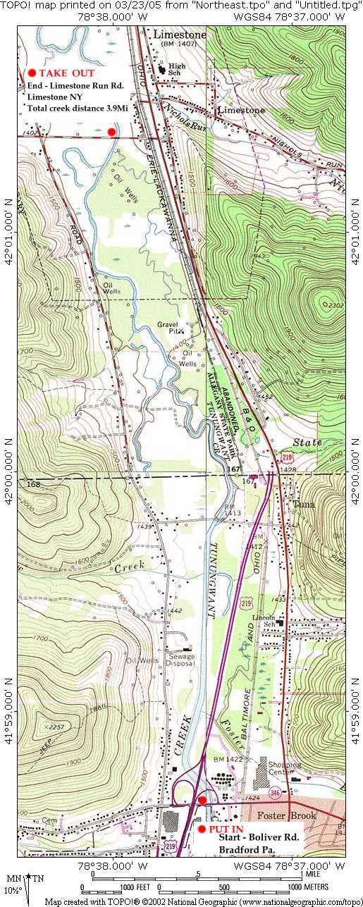
Printable Map- Click to enlarge
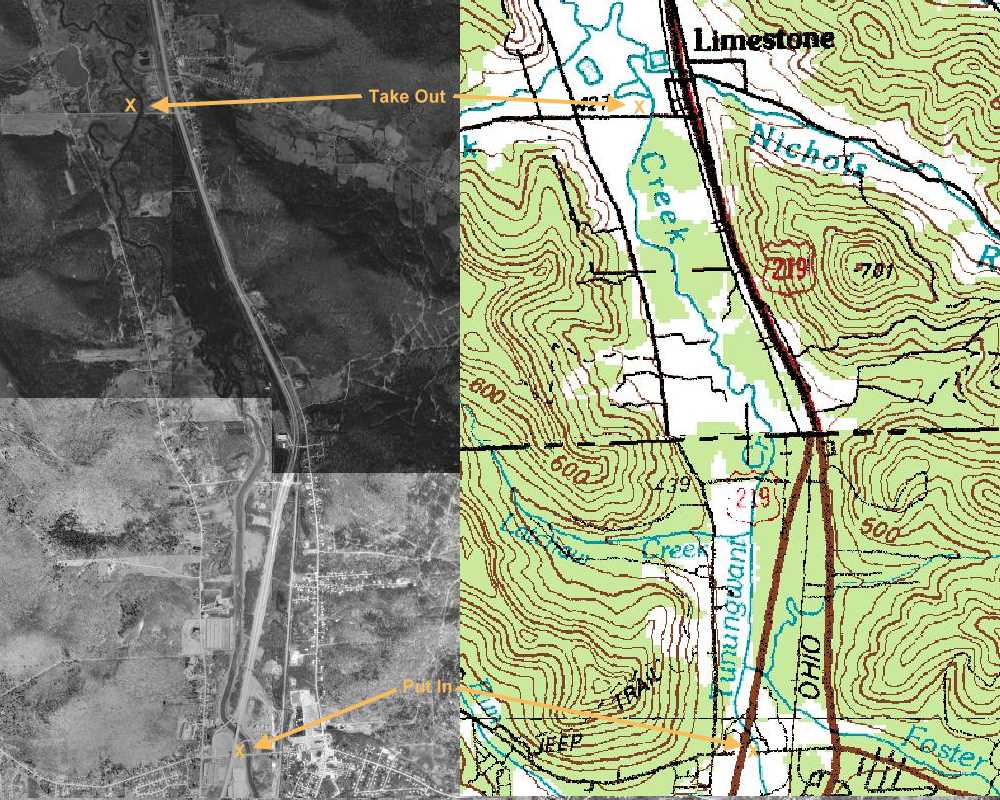
Printable Topo/Photo Map- Click to enlarge
Directions to the Tuna Creek kayak/canoe trip.
Directions from the north of Bradford, West (Jamestown, Buffalo, Erie) and East (Olean, Cuba, Wellsville).
Coming from NY state (east or west). Get off Rt 86 (formerly rt 17) at the "Bradford Limestone" exit. Head south on rt 219 (toward Bradford/Limestone).
Get off Rt 219 at the first Bradford exit (Foster Brook). The end of the exit is Bolivar Drive. Make a left onto Bolivar Drive, and go back UNDER the expressway (219) . There is a small trail head on the left (pull into the chain link fence) near the creek just past the underpass.
This is where we will start from. It's a small parking lot near the creek.
Directions from south of Bradford:
From 219 south into Bradford, take the last Bradford exit (Foster Brook). At the end of the exit, make a right onto Bolivar Drive. IMMEDIATELY after crossing the river, the trail head parking lot is on the right. Pull in the driveway between the chain link fences.
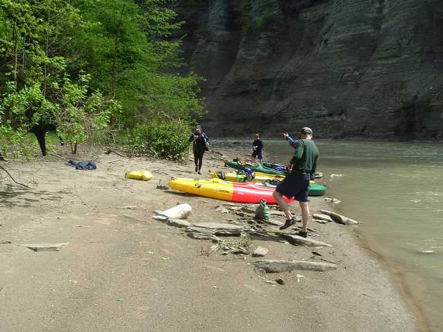
Here are pic's from a trip we did Saturday Mar 26th. It's sort of a "mini virtual tour" for those who has never been on the Tuna Creek.
Click the image to view full size

The "Crook Farm Trail" trailhead where we will start

This is the end of the trip (pic taken from bridge where we end)

This is the parking lot at the end of the trip
Tuna creek- Section Two:
Wednesday April 13th at 5 PM (4:30 to set cars) we are going to do a trip down the Tuna Creek from "Rockin' Ricks" in Limestone NY to Irvine Mills Bridge. This trip will take about an hour and a half to two hours. It (now) gets dark at 8:00 or so. Wednesday will be 55 and sunny ... so this should be a real nice early season trip .... BUT you must have a wetsuit (I have several to loan).
Tuna Creek Trip Map:
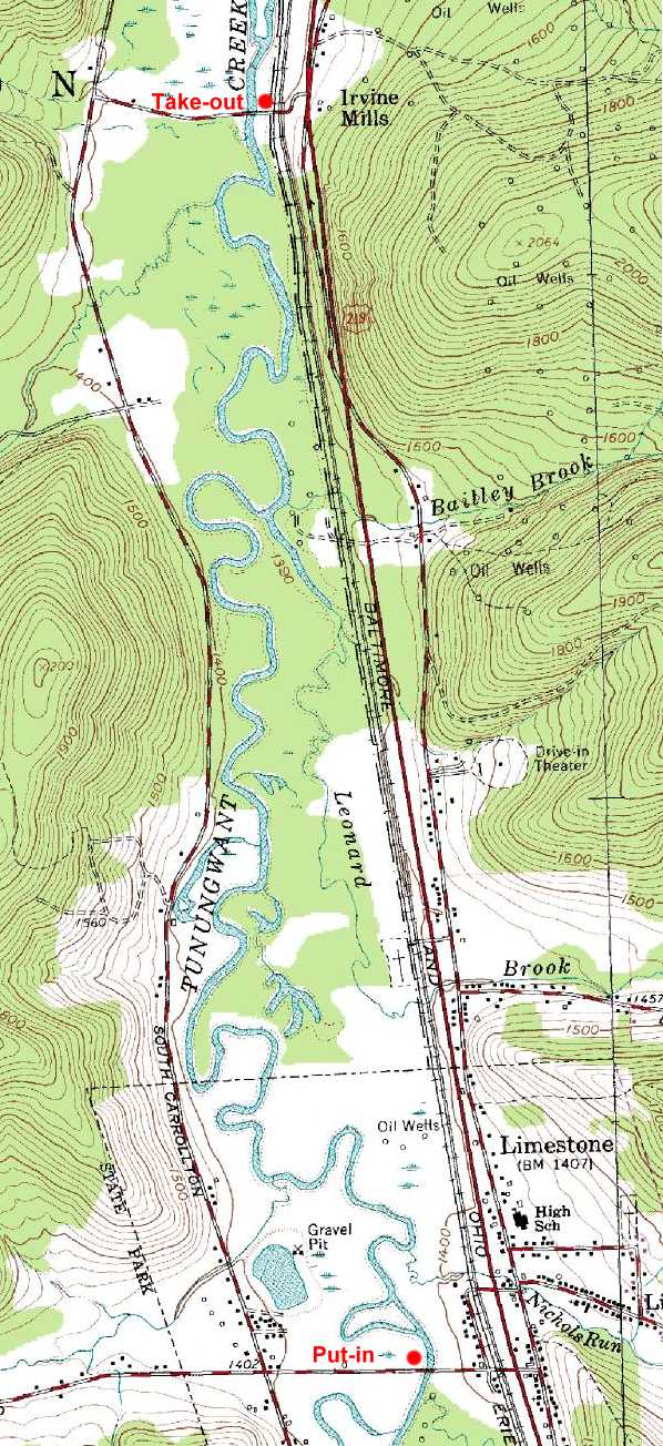
"Section Two"
|
Hi John,
I'm Don Shelters with the Zoar Valley Paddling Club and a good friend of Bruce Kershner's. A good friend of mine opened up a new raft company with the best self bailing rafts in Gowanda. His name is Trevor Heberline. His company is Snow And Rain Adventures, phone # is 1-866-889-7272 the address is 77 South Water St. Gowanda, N.Y. 14070. He has good rates, great new self bailing boats and some of the more experienced guides.
Could you please post his information on your web site?
Thank you in advanced.
I live in East Otto, 5 minutes from the main or south branch and plan on meeting you on one of your hikes.
Keep up the great work in Zoar (website etc....)
We have started a not for profit group called Cattaraugus Creek Watershed Task Force. we are a diverse group with many concerns for the whole watershed.
Peace, Stay connected, Don
|
Paddling Zoar Valley - Gowanda, NY
All photos on this page are click-able to view larger images
  
Just above Gowanda Passing Knife Edge Ridge Paddling through the "Gallery of the Giants"

Mick McMillan
May 15th SUNDAY ZOAR VALLEY NY
Kayaking in Zoar Valley
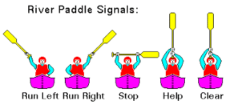
This was supposed to be a large trip! Nearly everybody cancled on us! I guess the weather was suposed to be bad, but we lucked out and it was a perfect day! The trip was Mick, Dave R, Mandy, Jake, and I. We took one truck and two cars to carry 5 boats.
We were on the water at 12 noon, but didn't come off the water until about 5:50. It was a long and fun day. I got to photo some waterfalls I missed out on on previous trips and we had a great lunch on the beach (Blue Boat Beach). After lunch, we climbed Knife Edge Ridge and logged a Geocache that is at the top. We also met two different groups of people and dogs at the top of the canyon.
The water level was about 2.25 on the Gowanda guage so we had a fun, but slow trip. The only other boaters we saw was a family in a raft.
There was only one guy at the nudie beach as we past. It was a cooler day and partly cloudy and most nudist won't dare to cross the creek (confluance) when the water is at 2 feet and above.
All in all it was a real fun day. Too bad everybody cancled out on this great trip!
Pic's from May 15th 2005
  
Pic's from May 15th 2005
Pic's from May 15th 2005

Pic's from May 15th 2005
Here are some helpful links to
find out just how much water is flowing in the creek. You might want to
check it out before hiking (in the stream), kayaking, canoing or
anything that might involve crossing the stream.
The CATTARAUGUS stream flow (NOAA)
The CATTARAUGUS stream flow (USGS)
The NOAA menu page
The NOAA Catt Creek Gage
The Creek Gage Guidelines main menu
The Guidelines for reading the Gage height
The Zoar Valley Paddlers Message Board
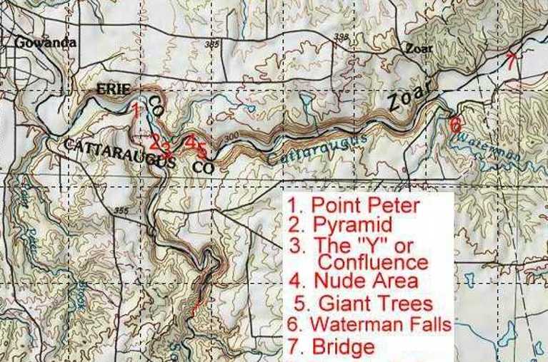
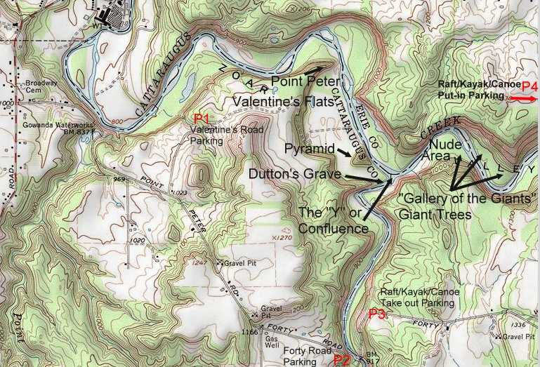
Zoar
Valley State Multiple Use Area
The Zoar Valley State
Multiple Use Area (MUA) is a 2927 acre state
owned multi use area located in the Town of Otto, Cattaraugus
County. Zoar Valley Gorge is centered around the Cattaraugus
Creek, and the South Branch of the Cattaraugus Creek. White water
rafting is popular on the Cattaraugus Creek, along with hiking,
exploring, photography (with many scenic waterfalls) and sunbathing,
bird watching, among other interests. These state lands
are included in the towns of Otto, Persia, and Collins. This is a VERY
dangerous area, so take great care! Some people may want to be aware,
there is an area with nude sunbathing and skinny-dipping. Although
there have been (false) reports that the "Nude Area" is no more, the
"Nudie Beach" (upstream from Valentine's Flats) is quite popular, and going strong. Although "swimming" is officially banned, all summer
long, you will see people playing in the water, up and down the creek!
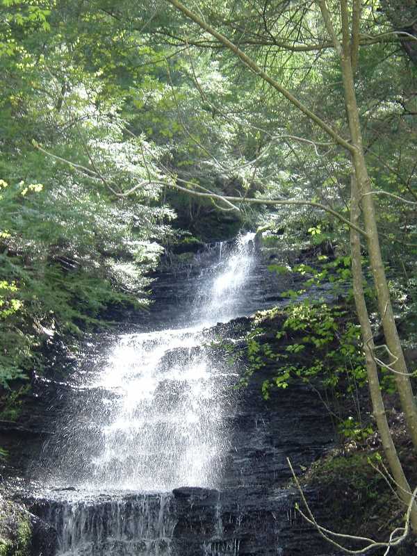
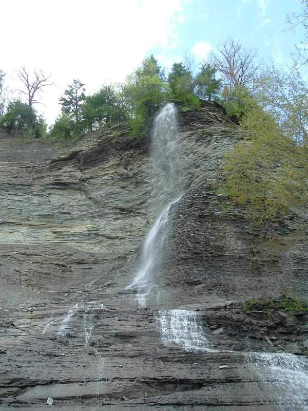
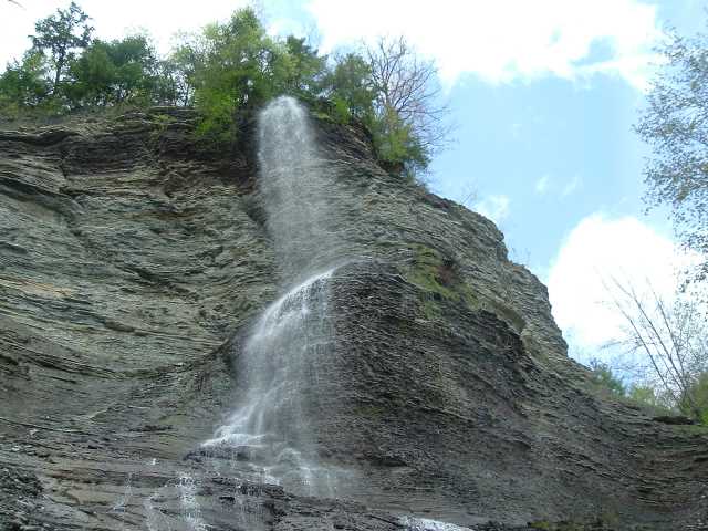
There are many waterfalls in the area, some are called "cascades" that
rain down from the cliffs that reach heights of 500 feet! NOTE: The MUA and Deer Lick Conservancy ends upstream from the Bear Point oxbow, and it is PRIVATE PROPERTY from Deer Lick Sanctuary to further upstream (on the South Branch). PLEASE do not trespass by hiking off the Zoar MUA property. I provided several detailed
maps (among the photos below) that you can print out as a guide for
hiking, kayaking and exploring.
DIRECTIONS TO THE AREA:
From Buffalo (I-90), take US Route 62 south to Gowanda. In
Gowanda, take the fifth left (east) on E. Hill St (0.6 miles
after crossing the creek). Drive to Broadway Road (0.6 miles).
Head south (right) on Broadway Road until reaching Point Peter
Road (0.7 miles). Turn east (left) onto Point Peter Road.
From the south, Jamestown, Take 62 into Gowanda, look for E Hill Street on your right, then drive to Broadway Road (0.6 miles).
Head south (right) on Broadway Road until reaching Point Peter
Road (0.7 miles). Turn east (left) onto Point Peter Road.
From the south, Salamanca, Olean, Bradford Pa, take 353
(Salamanca) to 62 at Dayton and go right into Gowanda. Then, look for E
Hill Street on your right, then drive to Broadway Road (0.6 miles).
Head south (right) on Broadway Road until reaching Point Peter
Road (0.7 miles). Turn east (left) onto Point Peter Road.
THEN ONCE YOU ARE ON POINT PETER ROAD:
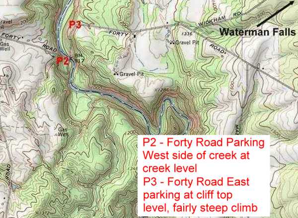
Valentine Flats Road is 1.0 mile from
Broadway Road, with a parking lot at the end.
Forty Road is the next left after Valentine's and has a large parking lot.
For Rafting Information Call:
ADVENTURE CALLS
RAFTING
(716)532-4996)
ZOAR VALLEY CANOE
(716) 532-2221 (800) 724-0696
Snow And Rain Adventures
phone # is 1-866-889-7272
77 South Water St. Gowanda, N.Y. 14070.
| Rafting and Kayaking is one of the biggest
attractions in our region. There are several bodies of
water in which to enjoy a full day of fun and
excitement. For general guidelines on our local rivers
and creeks - click
here. |
 |
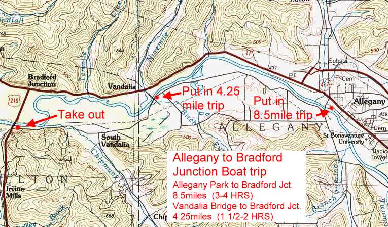
Allegheny River - The 54-mile trip on the Allegheny
River, devoid of dams, can be made without interruption at
sufficient water heights. At Clean, two large pipes crossing the
River's bed may cause a problem during low water. Near the
Junction of the Tunungwant Creek, vertical log piles are
concealed below the water surface. Log piles are also present in
other locations, especially above Portville.
At Salamanca, a shallow rift occurs above and below the
bridge. There are also some rifts between Salamanca and Red
House.
From Vandalia to the Allegheny Reservoir, most of the trip is
through the Seneca Nation of Indians' Reservation. The trip
through the Allegheny Reservoir can be rated smooth to rough
depending on the wind.
Cattaraugus Creek - Cattaraugus Creek offers the most
interesting canoeing stream in Western New York. It must be
approached with CAUTION. It is challenging, secluded in
sections, and very beautiful.
For detailed information on Cattaraugus Creek water levels and
safety information - click
here.
The entire length of Cattaraugus Creek, can be run season long
(Spring through Fall). Some sections of the Cattaraugus Creek,
especially the stretch through Zoar, should NOT be run at any
time except by experienced canoeists accompanied by someone who
knows the Creek.
The white water enthusiast may wish to take a wet and wild river
trip by rafting through Zoar Valley. These white-water rafting
trips are by reservation only. Make your reservations early in
the Spring to assure high water for rafting.
Cattaraugus Creek, South Branch - When running the South
Branch of Cattaraugus Creek, one should proceed with caution
especially in the area between Skinner Hollow Road and Forty
Road. It is noted that you will find a 6-foot river-wide
waterfall, (height varies 15 to 20 feet) on a blind corner. Here
the water flows into a horseshoe shaped drop with recirculating
currents. Following is another 6foot drop with a potential
pinning situation. Run this creek only if you are with someone
who has run it before. Not recommended in high water.
Conewango Creek - This creek is a slow meandering stream
with many overhanging trees. Portage is required around
occasional fallen trees. A beaver dam one-mile north of the
mouth of Little Conewango may necessitate portage. The first 5
miles below Conewango Valley flow sluggishly through a straight
State drainage ditch. The stream's redeeming feature is a
delightful series of easy rifts, 3 miles long, from the Route 17
bridge at Waterboro to Kennedy after which it joins the
Allegheny River at Killbuck.
Great Valley Creek - The water level of the Great Valley
Creek, which meanders through the valley, is for the most part
seasonal. At high water, this Creek can be run from
Ellicottville to the point where it joins the Allegheny River at
Killbuck.
Ischua Creek - This is an unusually fine run among hills.
During the Spring, it offers intermediate challenge to the canoe
enthusiast. There are occasional tricky spots under the bridges
and along railroad grades. Dead falls are the biggest problem.
This creek can only be run in high water.
Oil Creek - Oil Creek is an excellent spring and fall
waterway. It meanders through farmland and wooded areas. One may
encounter a few log jams. In the area of Wagner Hill Road, one
will encounter rock and rubble. Oil Creek is an area with an
abundance of wildlife.
Olean Creek - This is a continuation of the Ischua and
Oil Creeks. Moderately high water would make tire trip from
Hinsdale to the Allegheny River a relaxing one. However, the
Olean Creek is shallow and cannot be run most of the year. Some
snags as well as some fast, sharp turns may be encountered.
Oswayo Creek - An abundance of wildlife and waterfowl can
be seen on the Oswayo Creek. This creek is canoeable from
Shinglehouse, Pennsylvania to a point where it meets the
Allegheny River near Portville, New York.
Zoar Valley Whitewater Rafting - Zoar Valley is located
only an hour's drive south of Buffalo, New York. Transversing
some of the most spectacular scenery in Western New York, it
remains virtually hidden due to its difficult access. Certain
sections of the gorge can be seen from several remote vantage
points, but by far, the best view can be had from the river far
below.
|
Below is a listing of place you can raft or kayak:
Cattaraugus
Zoar Valley Paddling Club
9457 Harvey Road
Cattaraugus, New York 14719
Phone: (716) 257-9750
Website: www.zoarvalley.com
|
Gowanda
Zoar Valley Canoe & Rafting
Gowanda, New York 14070
Phone: (716) 679-7238
Alt. Phone: 1-800-724-0696
Website: www.zoarvalleyrafting.com
|
|
|
|
Use this handy Site Search
to search keywords on this site
CONTACT
US!
NEW! FAQ! Frequently asked Questions Page
All text and photos on this page © John V Stoneman

|