
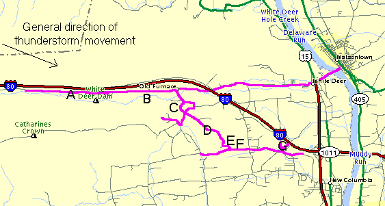
White Deer Township, Union County, Damage SurveyI set out during the mid afternoon and was out until early evening, investigating the damage which was located about 6 miles southwest from my house (my house is about 3 miles north of Watsontown). See the map of the damaged area here . The roads that have a purple line on them is generally where I drove. The letters, A through G, indicate the notable areas of damage... in the order that it occurred. However, it should be known that trees were blown down along the entire path. Most roads in the area were blocked/closed for up to a day. Many telephone poles and telephone and power lines were blown down. Most people did not get service back for a day. It is one thing to hear about the damage, or even see pictures, but it is entirely different to actually be there, as I was. The whole environment just feels totally different to actually see the damage first hand, and talk with the people that went through the storm. To hear about a tree snapped in half is one thing, but to stand in front of it in person is something else. It makes you think of the tremendous force that the wind had to snap a large, healthy, oak tree... and to rip out the top of a maple tree. The main access road that is there is named "White Deer Pike", as it originates in the village of White Deer. I took this road (which runs parallel to, and just south of, Interstate 80) from Watsontown to past the White Deer Dam. Between Watsontown and where I-80 crosses over White Deer Pike, there was almost no damage - I saw a couple tree limbs snapped in residents yards. Once I crossed under I-80 and just past Old Furnace, the tree damage got a little bit more frequent, with limbs down, and a few trees snapped... but still nothing to get excited about. As I approached the letter "A", trees began to be snapped even more frequently. One large tree fell across the back part of a barn (by the "B" on the map), crushing a section of it. Part of the right side of a barn roof also collapsed at the same location from the thunderstorm downburst winds... borderline F0/F1 strength at this particular location. Note the man to the right of the barn, in a blue shirt. He was cutting up a fallen tree at the time. As I continued driving west on White Deer Pike (toward White Deer Dam), damage was noticeable on both sides of the road... in the form of snapped or uprooted trees and limbs. Some of the trees were large. In fact, at one home just after the letter "B", there were two large trees on each side of their driveway - both were snapped and splintered a couple feet above the base. Just past the White Deer Dam, about 3/4 of a mile of rather impressive tree damage occurred (lesser damage continued over a larger area). Most was centered at the "A", extending out on either side of it. There were no houses here. Many trees were downed -- about 60% of the downed trees were snapped and 40% were uprooted. One of the interesting things about the snapped trees was this: Some were snapped at the base, others near head level, and others 40 feet up. There was a few rows and clusters of uprooted trees shown, including this cluster of three. In some areas, it was a jungle of snapped trees and branches, while in other areas there was a snapped tree next to a standing one. For this one mile stretch, the road was completely covered in leaves, as it had been completely blocked for one day. Also in this area, almost every telephone/power pole was snapped! After walking around along the road and into the woods, it was clear that the beginning of the damage path, where this damage occurred, was completely from thunderstorm downburst winds. Every damaged tree in this area, whether snapped or uprooted, fell from northwest to southeast... the direction of the thunderstorm movement. Even when limbs were snapped off of the tops of tall trees, they would fall to the southeast side of the tree. Absolutely no convergence (which would indicate tornadic activity) was noted in this area. Although I wouldn't call the pattern strongly divergent (which is associated with downbursts), it didn't take long to notice the divergence in the damage. After I continued west past this damage area, no other damage was noted. I turned around and headed back to Old Furnace, then made a right onto Dyer road. A short distance down the road (by "C"), there was tree damage on either side. Numerous trees were snapped and uprooted here. Some had the tops snapped out of them, with the bottom portion of the trunk undamaged. Others pulled up large parts of earth as they were uprooted. A street sign had dents and small areas of leaves stuck to it. This was from tree branches, leaves and debris smashing into it. The damage area here was a few hundred feet wide, and it stood out because the damage was more enhanced than just 500 feet away. I continued south for a very short distance down the road, and took some time to make a left and right turn at the intersection. To the right, I turned onto another back road... Shady Road. A short way up the road, several trees and limbs were downed. Some were uprooted, but most were snapped. On Hill Road, to the left of the intersection, I found a few trees down, but most of this area was fields. One of the trees was at least 2 feet in diameter, and was snapped a few feet above the base. A small shack less than 100 feet away was obliterated, with the debris blown in one direction down into a ravine. I now got back to the main road (Furnace road ) and continued south until I approached the "D" area. At one of the only houses here, a children's swing set was laying on the ground in front of a grove of trees... bent and twisted. I learned that it had been thrown across the yard, out of the damage track. A cloths line was also destroyed, a small shed overturned, and a few trees snapped a few hundred feet from this location. As I continued down Furnace road, it met up with New Columbia road (by the "E") At the corner, there was a damaged farm. He had numerous trees down on his large area of property. One of the trees by his house was not downed, but completely defoliated! This was hard to determine whether it was from the quarter to half dollar size hail that fell or the wind. I talked with the owner and he told me what it was like to go through the storm. "It got real black real quick", he said. "The heavy rain started and the wind came within seconds. I couldn't see anything out the window. It was just black. There was dirt and pine needles blowing up against the windows. You always hear people say the sound is like a freight train. That is the best way to describe it I guess. It was just a loud roar, between the wind and hail. And the rain... it was so heavy. You wouldn't believe it..." Besides the trees down, the roof of his large barn collapsed (see pictures 1 and 2) . A smaller shed/shack next to it also had the wall and roof closest to the barn collapse. Across the street from his house, lay several large trees that were downed. Most were cleaned up the day before, and stand with just the bottom part of the trunk left. Branches and limbs from trees were cut up and put into piles like this on the side of the road, so vehicles could get through. The owner of the property told me that if I had gotten there yesterday I would have seen the tremendous amount of earth that was pulled up as a tree was uprooted. On New Columbia road, by "F", a large section of a corn field was mostly flattened by the strong wind in excess of 60 mph. On a different field, quarter size hail destroyed 1500 acres of soy bean crops. I continued east on New Columbia road until I reached Deitrich road (near "G"). I made a left here. A short distance up the road there was another damaged farm. The owner had a barn on one side (left side) of the road and his house directly across the road. The back side of the barn roof was ripped off, and parts of it were thrown across the road and hundreds of feet onto the front and backyards of the owners house. The main rafters holding the roof together were found on the opposite side of the barn of where it was ripped off of... as is seen in this photograph. From inside the barn, you could see a 2x4 that was hurled through the plywood floor. Moving across the road toward his house, debris was scattered across the yard. In this picture, you will see pieces of the sheet metal roof scattered about (also note the downed tree limbs from the top of the trees). One sheet of metal was wrapped around the limb of a tree, while other pieces came to rest along side the road. A maple tree several feet away from his house had the top ripped completely off. Numerous other trees were also downed, most snapped or split, across his property. The power pole in front of his house was also snapped in half, and the TV antenna on top of his house was bent. The owner told me that he had been watching TV just before the storm hit, and saw the warning for his area. As soon as the wind and hail started, he and his two dogs went into the basement until the severe thunderstorm passed. At this farm, the strongest/damaging winds did not quite reach the ground... as is sometimes the case with downbursts and gustnadoes. The strongest winds at this location, estimated around 70-80 mph, were at and above roof level. Trees were snapped or ripped off at roof level, the power pole was snapped halfway up, the TV antenna was bent, and the barn roof blown off - nothing at the ground was damaged - windows were intact, as was siding, and no trees were snapped on the ground. One limb was split just above the ground (link to picture above), but by the condition of the tree and the size of the limb, winds of no more than 60 mph (probably closer to 55 mph) were needed to do this. At this location, I'd say top winds on the ground were 45-55 mph, and top winds at and above roof level were 65-75 mph, possibly approaching 80 mph. This was the last notable area of damage. Scattered to widely scattered tree damage occurred until near the town of New Columbia. I should note that almost no convergence (which would indicate a tornado/gustnado) was found along the 7-8 mile long damage path. Most, if not all, of the damage I surveyed clearly showed divergence... indicative of downburst winds. All debris was blown in the same direction, including trees falling in the same direction (generally northwest to southeast).
Email: BowEchoCPA@suscom.net |
