
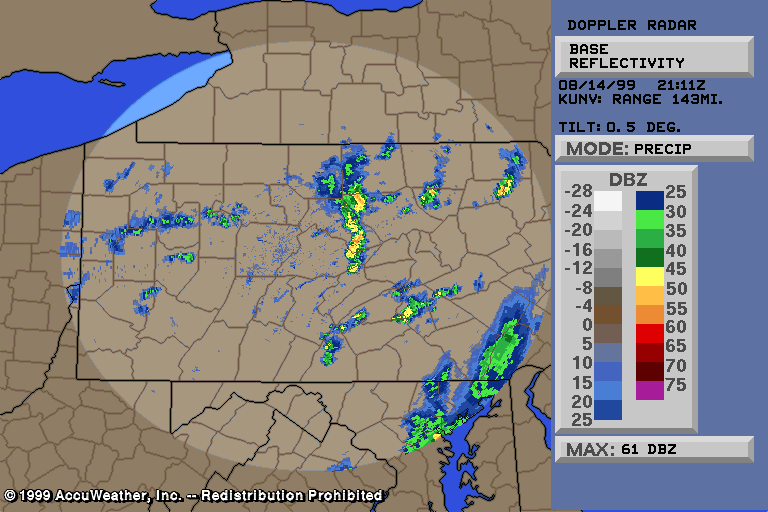
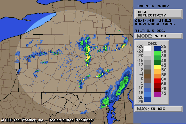
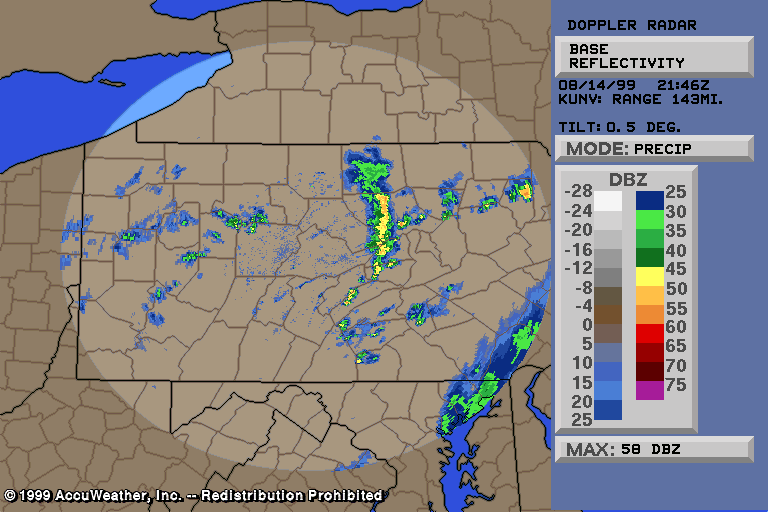
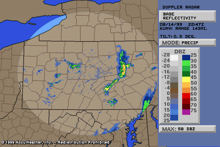
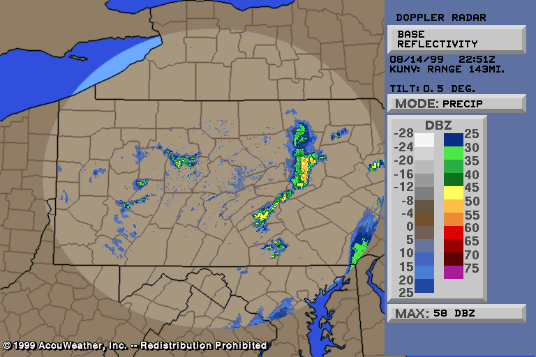
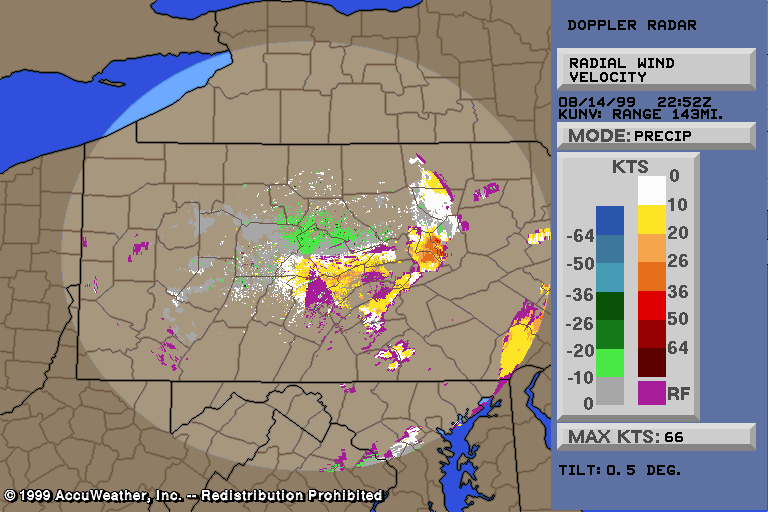
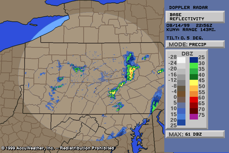
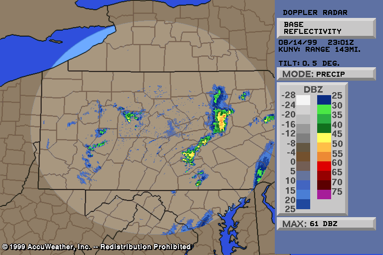
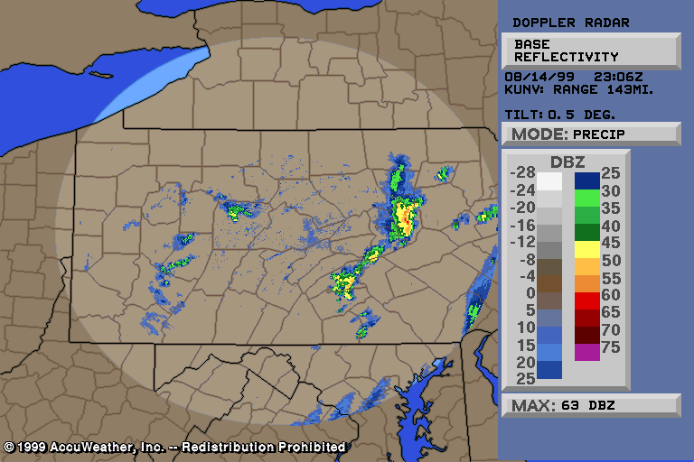
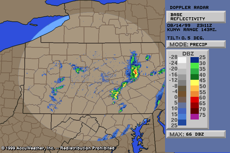
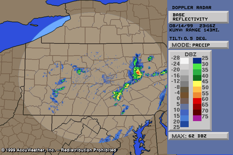
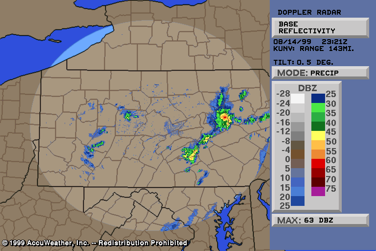
August 14, 1999 Severe ThunderstormsThunderstorms developed along and ahead of an approaching cold front, most during the late morning and afternoon. Some isolated severe thunderstorm cells formed across the Lower Susquehanna Valley... but the most intense damage came from a line of thunderstorms which moved over the Middle Susquehanna Valley. This paper will focus on that. Before learning about the damage, have a look at the various radar images from the line of thunderstorms... which evolved into a bow echo: Radar reflectivity data at 5:11 pm indicated the line of thunderstorms... from northwest Lycoming county south through Clinton county and to the Centre/Mifflin county border. An interesting feature to note in Clinton county is the presence of a RIN (Rear Inflow Notch). A severe thunderstorm warning was issued for southern Clinton county a few minutes ago pertaining to these storms. Radar at 5:21 pm showed the line bowing out in two areas... in northwest Lycoming county and southern Clinton county. Strong winds were occurring with this line of thunderstorms. Most people were seeing gusts as high as 35-40 mph.... while a few select locations were receiving thunderstorm wind gusts over 50 mph... with isolated trees and limbs being snapped. 5:46 pm reflectivity data showed the line of strong thunderstorms now from western Union and Snyder counties.... north through Lycoming county. Strong, gusty winds continue with these storms... and in some cases they are locally damaging... downing trees, limbs, and power lines in a few locations. 5:51 pm reflectivity data. Strong thunderstorm winds at a minimum of about 40 mph continue. Again, damaging wind is occurring in a few select locations at this time as well. Between 5:50 and 6:45 pm... the entire line of thunderstorms formed a bow echo as it moved over the Mid Susquehanna Valley. The strong thunderstorm wind gusts became increasingly higher and more widespread along and east of US Route 15 and the Susquehanna River. Radar at 6:47 pm showed the bow echo in the Mid Susquehanna Valley. At and near the apex of the bow echo... which is between Danville and Bloomsburg on the radar image linked just above... widespread thunderstorm wind gusts of 40-50 mph are occurring. Several areas in western Columbia and eastern Montour counties... the strongest part of the bow echo now... are seeing gusts of 50-60 mph. This is resulting is sporadic trees, limbs, and wires being downed. 6:51 pm radar data. The bow echo continues to produce strong gusty winds... now across all of western Columbia county and southern Montour county. It is proving to be damaging in a few spots with trees and tree limbs snapping and power lines being downed. The situation is becoming more and more serious with each passing minute... and shortly a path of widespread damaging thunderstorm winds would occur along and near US Route 11 in Columbia county. 6:52 pm velocity data showed the very strong winds with these storms in far western Columbia county near the Montour/Columbia county border. 6:56 pm reflectivity data shows a line of severe thunderstorms in Columbia county. Widespread thunderstorm wind gusts over 50 mph are now occurring... with embedded areas reaching 60 mph and tree damage occurring. 7:01 pm radar data. The thunderstorms were now producing widespread 45-55 mph winds in Columbia county where the storms are indicated on the radar image linked in the sentence above. 7:06 pm radar data indicates an area of severe thunderstorms with large hail and damaging winds in Columbia county. It is around this time when the most widespread damage is beginning to occur. Thunderstorm wind gusts are reaching 60 mph over a large area (i.e., several miles). Radar at 7:11 pm continues to show an intense area of severe thunderstorms with large hail and damaging winds in east-central Columbia county... just west of Berwick... in the vicinity of Mifflinville. Vicious, very dangerous, downburst thunderstorm winds and large hail is occurring right about now in and around the town of Mifflinville (see my damage survey below). 7:16 pm radar. Severe thunderstorms continue to produce widespread damaging winds in eastern Columbia county. 7:21 pm radar image. Severe thunderstorms continue... causing wind damage from Mifflinville to Berwick... and in surrounding, rural areas of Mifflin Township. At 7:26 pm... Berwick is being slammed by large hail... damaging winds... and absolutely torrential rainfall. Severe thunderstorms have also now moved into far western Luzerne county... and thunderstorm winds caused wind damage in and around
the Nescopeck area.
Where the storms first became severe... in southern Clinton county... a few trees were downed in Porter Township. Then as the line of thunderstorms moved farther east/southeast... toward the area where I live... thunderstorm winds caused pockets of wind damage. Along US Route 15 in eastern Union county north of Lewisburg... several trees were snapped alongside the highway. In Northumberland county... several trees and limbs were snapped... bringing down power and cable lines. In Delaware Township... a tree was snapped and fell across Crawford Road (TR 648). At the corner of SR 1001 (Musser Lane) and SR 54... a large tree was snapped and fell across SR 1001. It pulled down power and cable lines which fell across SR 54... and a utility pole was pushed over and leaning significantly. Both roads were closed for numerous hours. Several feet north of SR 54 along SR 1001... two other trees were snapped on two separate people's property. Then, along SR 1005 (Seagrave Drive) at least 2 trees and a few small branches were snapped. Within the borough of Watsontown... a large tree limb was snapped out of a tree in a person's front yard. Being that the yard was quite small, as it is in town, the large limb took up much of the property. It is very fortunate that there were no children playing there, or something of like. In the Milton area... the PP&L sub-station was knocked out... resulting in the outage of all seven lines going out to surrounding areas. Thousands of people were without power through the night... including nearly 6,000 customers in the borough of Milton alone. Traffic signals stopped working... and the Fire-Police were called in to direct traffic. Farther southeast... in Montour county... it is very likely that there were several trees downed in the county. But as in northern Northumberland county described in the paragraph above, they were just simply not reported to the NWS. There are, however, two reports that I am aware of (one from NWS); a tree was snapped in Washingtonville... and a large tree was downed just outside of Danville. In Columbia county, this is of course where the worst damage occurred. Isolated, sporadic, downed trees and limbs likely occurred across much of the county. However... the most widespread damage was centered in and around Mifflinville in east-central Columbia county. Damage continued through the Berwick area... and in Mifflin Township just south of the two towns. Damage also likely occurred just north of the two towns... in South Centre, North Centre, and Briar Creek Townships. However, the damage survey that I completed was focused primarily along and south of US Route 11. My findings are below: By far, Mifflinville was hit the hardest. Everywhere you look there was damage. Almost every single street in the town had trees down along or on them. Railroad tracks also had trees down on them. Dozens and dozens... over 100... of trees and limbs were down in and around Mifflinville. One side of a barn roof was torn off... and it was tossed over the top of the building coming to lay across one road. A couple other buildings suffered relatively minor roof damage... with a few pieces of sheet metal flying off. One business had siding peeled off. Several trees hit houses and other structures... causing damage to them. Two sheds were flattened by trees... while one house in particular had considerable damage to its corner as a tree crushed it. Several vehicles were hit by trees... one being crushed and the others damaged. Corns fields took a big hit... with numerous stalks snapped/bent. On US Route 11 just north and northeast of Mifflinville... portable toilets (used when doing construction there) were knocked over... construction signs were thrown around... and trees fell across the major highway. A large advertisement billboard was blown down and around... now just mangled pieces of steel. Quite a few road signs... such as speed limit ones... were bent at the ground. I was surprised at how many of these were bent actually. Some were 3 and 4 in a row. Then in the Berwick area damage was not as widespread... but still it was not isolated either. Trees, limbs, and lines were down across the town. Again signs were blown down... an antenna bent... and siding ripped off the side of a house. On one street... a tree snapped and completely blocked the road. It took down power lines and a utility pole as well. Thunderstorm winds was the culprit... probably as high as about 70 mph. However, downburst wind of 60 mph was felt across the entire town... unlike in some other cases where wind that strong is much more localized. The widespread nature of 60+ mph winds was the reason that the entire town and surrounding area experienced similar damage. Most debris was blown west to east... corn all down in a straight line. Actually, over the town and surrounding township... there appeared to be a classic fanning out of the damage... with a strongly divergent pattern at times. But for a time over just a few blocks in the town of Mifflinville, I began to have second thoughts. There was no clear evidence of a gustnado... but the way some of the damage occurred it did not show as much divergence. It is possible that a strong eddy or two spun up at corners of buildings. Also can't rule out a brief gustnado along the leading edge of the bow echo... but thunderstorm winds and associated divergence dominated by far. There was certainly not enough evidence to classify the damage as anything but thunderstorm winds. See an LSR from NWS-CTP for some of the damage reports. As always, and this time was no different, there is damage that was not reported to NWS or just did not appear on the LSR. A complete listing of all images/text available for this event can be found here. Included are numerous radar images not linked above
Email: BowEchoCPA@suscom.net |
