John Reynolds / Gypsy Dreams
MILE" 982"
 Another nice anchorage a few miles south is on the S side of the
Jensen Beach Bridge. As long as you don't get to far W near the shore there is plenty
of water. Just tuck yourself in amongst the assortment of derelict vessels. There is a city
park right there at shore to tie up your dingy. Jensen beach has a bit more character
within walking distance. There is a big Publix grocery easy walking distance and many
shops & restaurants along shore. The main part of town is about 4 blocks S of the bridge.
If you can find a place to tie up there it would be more convent to dingy there rather than
beach your dingy in the park. There is a big Boat Yard there along with bait & tackle shops
so you should be able to find a spot. Sorry I left before I checked everything out. I will be
back though. It looked like a fun place. A few good-looking pubs right there.
Another nice anchorage a few miles south is on the S side of the
Jensen Beach Bridge. As long as you don't get to far W near the shore there is plenty
of water. Just tuck yourself in amongst the assortment of derelict vessels. There is a city
park right there at shore to tie up your dingy. Jensen beach has a bit more character
within walking distance. There is a big Publix grocery easy walking distance and many
shops & restaurants along shore. The main part of town is about 4 blocks S of the bridge.
If you can find a place to tie up there it would be more convent to dingy there rather than
beach your dingy in the park. There is a big Boat Yard there along with bait & tackle shops
so you should be able to find a spot. Sorry I left before I checked everything out. I will be
back though. It looked like a fun place. A few good-looking pubs right there.
MILE"993"
 At the risk of overcrowding a favorite spot, don't miss an overnight anchorage at Peck Lake.
It's a wide spot on the ICW just S of the St. Lucie Inlet. A Beautiful little anchorage with
a narrow strand of State Park beach between you and the Ocean and a wonderful long
strand of beach that goes all the way to the inlet. Across the inlet from the point is some
of the most expensive real estate in Florida. If you want to walk an empty beach this is a
pretty good spot. There are always a few sunbathers near the access point but walk a little
ways and you'll be by yourself. Just on the W side of Peck Lake is a very fancy development
that has a little store with limited supplies but ice. You'll see their little shuttle pontoon-boat
taking people back and forth to the beach.
At the risk of overcrowding a favorite spot, don't miss an overnight anchorage at Peck Lake.
It's a wide spot on the ICW just S of the St. Lucie Inlet. A Beautiful little anchorage with
a narrow strand of State Park beach between you and the Ocean and a wonderful long
strand of beach that goes all the way to the inlet. Across the inlet from the point is some
of the most expensive real estate in Florida. If you want to walk an empty beach this is a
pretty good spot. There are always a few sunbathers near the access point but walk a little
ways and you'll be by yourself. Just on the W side of Peck Lake is a very fancy development
that has a little store with limited supplies but ice. You'll see their little shuttle pontoon-boat
taking people back and forth to the beach.
MILE "832"
 Halafax River, Daytona Beach just north of marker #45 east side
off the channel anchor in 7 feet of water. The bottom is soft and good holding tide is
1 foot .
Halafax River, Daytona Beach just north of marker #45 east side
off the channel anchor in 7 feet of water. The bottom is soft and good holding tide is
1 foot .
MILE "878"
 Titusville Harbor at last report was allowing only 24 hour stop over in the
harbor. There are 2 marina here one with a lift and shopping across the street.
Titusville Harbor at last report was allowing only 24 hour stop over in the
harbor. There are 2 marina here one with a lift and shopping across the street.
MILE "885"> You can anchor south of the bascule bridge at Addison Pt. You will find 7 to 9 feet of water
either side of the bridge . Pick the best side for the weather. Tide in this area is almost
nil bottom is mud fair holding.
You can anchor south of the bascule bridge at Addison Pt. You will find 7 to 9 feet of water
either side of the bridge . Pick the best side for the weather. Tide in this area is almost
nil bottom is mud fair holding.
MILE "914"
 Indian Harbor Beach is after marker #102 and almost to the bridge
turn to port and head across to the harbor entrance. Favour the right entering and anchor
in 12 feet of water .Tide is minimal and the bottom is soft.
There is a dingy at the marina and shopping at a near by mall.
Indian Harbor Beach is after marker #102 and almost to the bridge
turn to port and head across to the harbor entrance. Favour the right entering and anchor
in 12 feet of water .Tide is minimal and the bottom is soft.
There is a dingy at the marina and shopping at a near by mall.
Mile "951"
> Vero Beach marker #137 is on the port side guide your self into the
channel and follow the markers into the harbor. Anchor north of the marina in 10 feet or
better water . the bottom is mud and good holding no tide .I bought some chain on special
at the marina and did a good impression of Jacob Marilee getting it back to the boat.
Vero Beach marker #137 is on the port side guide your self into the
channel and follow the markers into the harbor. Anchor north of the marina in 10 feet or
better water . the bottom is mud and good holding no tide .I bought some chain on special
at the marina and did a good impression of Jacob Marilee getting it back to the boat.
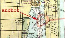
MILE "1014"
> Lake Worth at marker #27 turn to port and follow marked channel off the
ICW and north into a quiet anchorage. At the northern end you can beach a dingy and
follow the road for a short walk to a well supplied mall. Bottom is soft and good holding.
Lake Worth at marker #27 turn to port and follow marked channel off the
ICW and north into a quiet anchorage. At the northern end you can beach a dingy and
follow the road for a short walk to a well supplied mall. Bottom is soft and good holding.
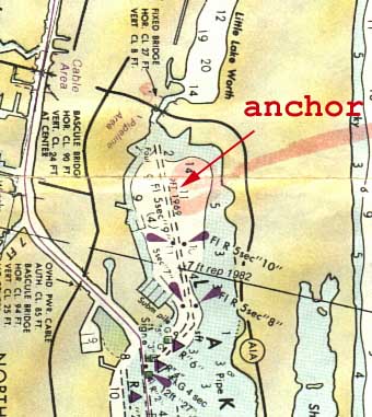
MILE "1018"
>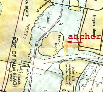 Peanut Island at Lake Worth Inlet is after marker #43 follow the south
shore of the island past the Coast Guard station and around the west side to anchor in 10 to
15 feet of water . The bottom is sand and good holding. Set your hook and expect to
swing when the tide change. You can dingy to a park on the west shore of the ICW and
its a short to the highway to shop. This is a good anchorage to get ready to make a crossing
of the gulf stream to West End in the Bahamas.
Peanut Island at Lake Worth Inlet is after marker #43 follow the south
shore of the island past the Coast Guard station and around the west side to anchor in 10 to
15 feet of water . The bottom is sand and good holding. Set your hook and expect to
swing when the tide change. You can dingy to a park on the west shore of the ICW and
its a short to the highway to shop. This is a good anchorage to get ready to make a crossing
of the gulf stream to West End in the Bahamas.
 Fernandina Beach Harbor Anchorage is off the ICW between marker
#24n to #26n . Anchor in 8 feet of water and avoid the shoal an the west shore.
Tide is 6 feet and the bottom is soft mud .The Florida Welcome station and marinas offer
the traveller a pleasant chance to refresh and reprovision.
Fernandina Beach Harbor Anchorage is off the ICW between marker
#24n to #26n . Anchor in 8 feet of water and avoid the shoal an the west shore.
Tide is 6 feet and the bottom is soft mud .The Florida Welcome station and marinas offer
the traveller a pleasant chance to refresh and reprovision.  The South Amelia River provides a pleasant anchorage
between marker #39 and #41 . Ease in to the east shore and anchor Ľ mile above the
Harrison Creek . Water is 10 to 15 feet deep with a mud bottom and tide is 5 feet .
The South Amelia River provides a pleasant anchorage
between marker #39 and #41 . Ease in to the east shore and anchor Ľ mile above the
Harrison Creek . Water is 10 to 15 feet deep with a mud bottom and tide is 5 feet .  Pine Island anchorage is at marker #25 turn to port and proceed
about Ľ of a mile off the ICW . Anchor in 12 feet of water the bottom is soft mud and
good holding. Tide here is only 2 feet.
Pine Island anchorage is at marker #25 turn to port and proceed
about Ľ of a mile off the ICW . Anchor in 12 feet of water the bottom is soft mud and
good holding. Tide here is only 2 feet.  St.Augustine is after the Bridge of the Lions . Anchor off the Municipal
Yacht Pier well clear of the channel and the west shore to avoid the shoals. The bottom
is hard and difficult to get a bite on, set two anchors up and down stream for a 4 foot tidal
change. The current here is swift and its not uncommon to drag anchor if not set properly,
use plenty of scope.Groceries are 6 blocks west on King st across from the post office.
You can tie up your dingy at the floating dock.
St.Augustine is after the Bridge of the Lions . Anchor off the Municipal
Yacht Pier well clear of the channel and the west shore to avoid the shoals. The bottom
is hard and difficult to get a bite on, set two anchors up and down stream for a 4 foot tidal
change. The current here is swift and its not uncommon to drag anchor if not set properly,
use plenty of scope.Groceries are 6 blocks west on King st across from the post office.
You can tie up your dingy at the floating dock.