MILE "82"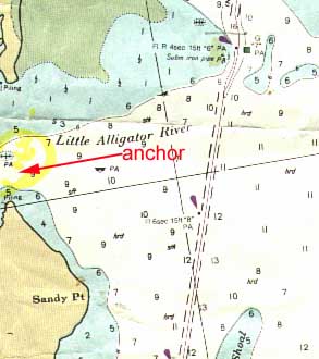 Little Alligator River is to starboard at red marker "8". Proceed about 2 miles off the ICW and anchor just around the point. Stay 200 yd. off the shore to as you round the point and you should be in water charted at 9 ft. It is not recommended to venture too deep into the bay here without charts. The ICW chart ends at the point and wrecks can be seen aground inside the bay.
MILE "84"
Little Alligator River is to starboard at red marker "8". Proceed about 2 miles off the ICW and anchor just around the point. Stay 200 yd. off the shore to as you round the point and you should be in water charted at 9 ft. It is not recommended to venture too deep into the bay here without charts. The ICW chart ends at the point and wrecks can be seen aground inside the bay.
MILE "84"
 If you need some provisions, fuel or just a break, there is a restaurant and a gas station at the western shore by the bridge. Anchor on either side of the bridge before moving on. This is a fair weather anchorage as it provides protection only from the west.
MILE "102"
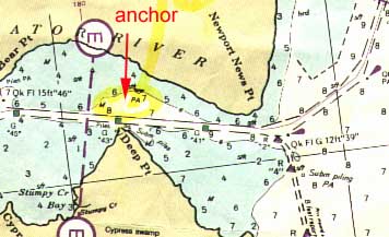 Across the ICW from Deep Point is what appears to be a mooring for tugs or barges (possibly used to wait out storms on). This is a good anchorage and easy to get at, but it is exposed to south east winds and gets uncomfortable when the weather is from that direction.
MILE "105"
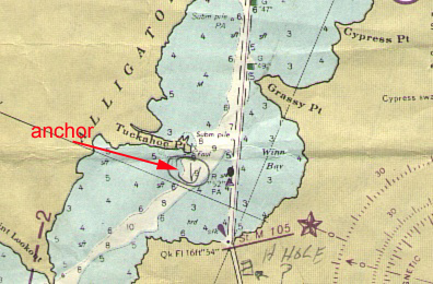 Further along is Tuckahoe Point, one of the most beautiful spots to spend a night in. Stay in the ICW until you are half way between Grassy Point and Tuckahoe Point then turn south with Grassy Point directly off the stern. Stay at least 100 yd. off Tuckahoe Point and anchor here. You should have no problem setting your anchor, as the bottom is soft mud and fair holding. There is no significant tide.
MILE "127"
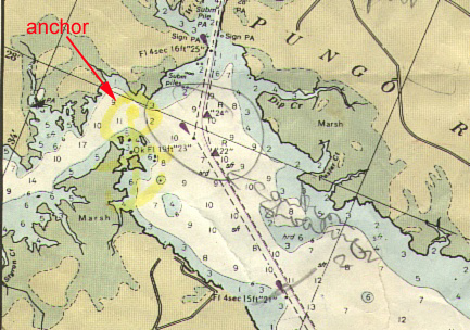 Head north off green marker "23" about half a mile. You can anchor in 10 to 12 ft. of water. Watch the depth here and avoid getting too close to the shore. The anchorage is in a marsh with not much protection from the wind but the bottom is mud and good holding. Tide range is minimal.
MILE "135"
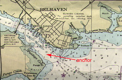 The Belhaven anchorage is located behind the breakwall on the port side side. The bottom is mud and fair to poor holding so set your anchor well. After the last 100 miles of remote anchorages, you might be ready for a rest with an opportunity to provision and explore. An excellent buffet can be found at the River Forest Marina. The dock master will direct you to where you can tie up the dinghy when you come ashore. For a small fee you can rent a golf cart to go into town and shop.
MILE "140"
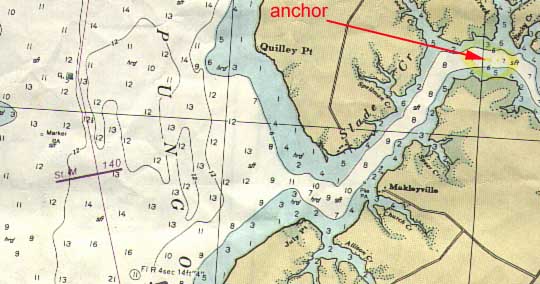
Slade Creek is unmarked but easy to enter and provides good protection in most weather. The bottom is mud and good holding. You are in a marsh with some high points of land to beach a dingy on.
MILE "175"
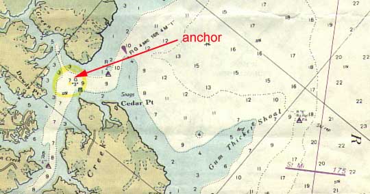 Broad Creek is to starboard off red lighted marker "4". It is well marked and a pleasant anchorage can be found there. If you work your way in, your rewards will be good holding and good protection. The tide here is about 2 ft.
MILE "203"
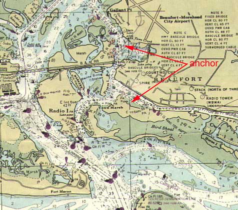 Beaufort, North Carolina is a popular seaport for boats travelling offshore as well as along the ICW route. There are two anchorages in the vicinity. To get to the first one, turn to port at marker "35", into Town Creek. It seems as this anchorage catches the overflow from the main anchorage which is across from the town docks in Taylor Creek. To get to the Taylor Creek Anchorage continue along past Town Creek through the bridge and turn to port at marker "11". Both anchorages are well served by small shops near by. The town dock has a vehicle available on loan if you need to shop further inland. The bottom is sand and good holding. Two anchors are needed here, as it is usually crowded. The tide is about 3 ft. The dingy dock is on the eastern end of the municipal marina.
MILE "229"
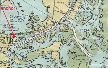 Swansboro anchorage is to the starboard at red ICW marker "46C". Go past the harbour and anchor off the bridge in 12 ft. of water. The current runs strong here. The bottom is sand and good holding, with a tide about 2 ft.
MILE "244"
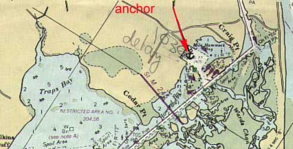 Craig Pt. Anchorage is in Mile Hammock Bay, to starboard at red marker "66". Entrance to the bay is over a 5 ft. bar. The depth inside is 8 to 10 ft. with a tide of about 2 ft. The holding is good if you can get the anchor set in the clay bottom. The bay is part of the Marine Corps complex and civilians are not allowed ashore.
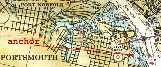 Portsmouth Naval Hospital is to starboard as you pass red lighted bouy "36" on the way south. Anchor here as close in as your draft will allow (tide is about 3 ft.). The bottom is good holding. This is a popular stop before continuing down the ICW, in spite of the wake created by the heavy commercial traffic. The marina here has fuel, a restaurant, and a store with boating supplies and staples
 Further south is Blackwater Creek at red marker "46". Depth at the entrance is 6 ft. but the bottom is soft and the holding good. Feel your way in and anchor in the quiet creek.
 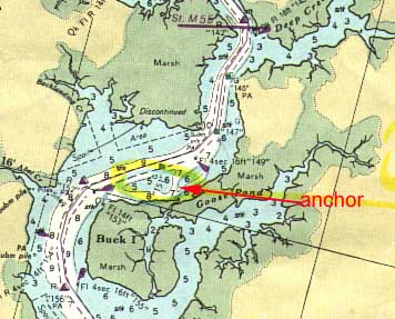 Buck Island anchorages are on both the north and south side of the island. Green marker "153" marks the entrance to the north anchorage. Leave the channel and marker to starboard. Anchor off the island's north shore with the 5 ft. shoal to the north of you. The southern anchorage is in 7 ft. of water between green markers "157" and "159". Anchor here to the west of the channel. Both anchorages are exposed to wind. The southern anchorage is also exposed to waves brought in by northerly winds. The bottom is good holding and the tide is less than 1 ft.
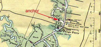