
Page 2
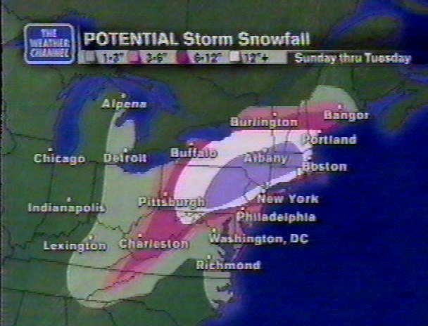
Sunday March 4th:
 |
A Winter Storm Warning was posted.
SPECIAL WEATHER STATEMENT
National Weather Service New York NY
1030 AM EST Sun Mar 4 2001
A winter storm warning remains in effect from late this afternoon through Tuesday morning
A coastal flood watch remains in effect from late Monday into Tuesday for the entire Tri-State region coastline.
A low pressure center over Tennessee will move east northeast this afternoon and tonight, reaching the mid Atlantic coast by daybreak Monday. This low will then intensify as it drifts northeastward over the Western Atlantic during Monday. The low will pull away from the coast during Tuesday.
Our region can expect snow to begin late this afternoon and continue into Tuesday. Although the bulk of the precipitation is expected to stay as snow, somewhat milder air may intrude along the coast causing the snow to change over to or mix with sleet for awhile during Monday. There is even a chance that it could change over to or mix with rain if the track of the storm changes just a bit. At any rate, a change over to sleet would reduce the snowfall amounts across coastal locations.
The storm is still expected to perform a loop while it is over the coastal Atlantic waters during Monday. Colder air will move back in while this occurs so any sleet or rain would change back to snow along the coast late Monday and Monday night.
Therefore, for New York City and Long Island the scenario looks something like this. Snow beginning late today, perhaps changing to sleet and rain during the day Monday, going back over to snow Monday night. Most of the accumulating snow will occur late Monday and Monday night into early Tuesday. Total accumulation by Tuesday is expected to range between 6 and 12 inches.
Coastal Connecticut will most likely not see any rain but could see the snow mix with or change over to sleet during the day Monday. It will go back over to snow late Monday and Monday night. Total accumulation by Tuesday is expected to range between 12 and 18 inches.
Interior portions of the Tri-State including the lower Hudson Valley, northeast New Jersey and interior Connecticut will remain all snow. As such, total accumulations by Tuesday is expected to range between 12 to 24 inches.
 |
The 3 PM Winter Storm Warning by the NWS seemed to have the storm nailed down.
SNOW SPREADING ACROSS THE REGION WILL CONTINUE TONIGHT. THE SNOW IS EXPECTED TO ACCUMULATE BETWEEN 2 AND 4 INCHES OVERNIGHT BEFORE IT MIXES WITH SOME SLEET. DURING THE DAY MONDAY...A MIX OF SLEET AND FREEZING RAIN DURING THE MORNING...CHANGING TO MAINLY PLAIN RAIN. AS SUCH NO ADDITIONAL ACCUMULATION IS EXPECTED DURING THE DAY. MONDAY EVENING THE RAIN CHANGES TO SLEET THEN BACK TO ALL SNOW. BY DAYBREAK TUESDAY 3 TO 6 INCHES IS POSSIBLE. DURING TUESDAY THE SNOW WILL CONTINUE WELL INTO THE AFTERNOON...THEN GRADUALLY TAPER OFF. FINAL SNOWFALL ACCUMULATIONS ARE EXPECTED TO RANGE BETWEEN 6 AND 12 INCHES. IN ADDITION...A STRONG NORTHEAST WIND WILL DEVELOP MONDAY INTO TUESDAY WHICH WILL MAKE TRAVEL EVEN MORE DIFFICULT.
| Time | Conditions | Temperature | Wind | Barometer| 10 AM | Overcast | 35.8 degrees | NE 4-8 mph | 30.19 F | 2 PM | Overcast | 34.6 degrees | E 5-10 mph | 30.16 F | 5 PM | Overcast | 33.5 degrees | E 4-8 mph | 30.16 S | 10 PM | Light Snow | 30.5 Degrees | NE 2-6 | 30.04 F | |
 |  |  |  |
It didn't start to snow until @ 8:45 PM & it was very light & ended @ 10:15 PM. It now looked like the overnight snow would only be 2 or 3 inches. Monday Night into Tuesday seemed to be the worst period. Snowfall was now expected to be 6-10 inches for Long Island, almost a foot for New York City, & away from the coast up to 2 feet. Winds on Monday Night into Tuesday could gust to over 50 mph. The storm was slowly developing off the Virginia coast. It would slowly move south of Long Island on Monday, but the Upper Level Low would keep it from going out to sea. In fact the storm would do a loop and intensify rapidly. 11:30 PM-Winter Warning Statement:
LOW PRESSURE OFF THE VIRGINIA COAST WILL INTENSIFY OVERNIGHT & SLOWLY MOVE TO THE NE. THE LOW WILL STALL SE OF LONG ISLAND MON AFTERNOON INTO MON NIGHT...BEFORE MOVING AWAY FROM THE AREA ON TUESDAY.
A WINTER STORM WARNING IS ISSUED WHEN SEVERE WINTER WEATHER IS EXPECTED TO OCCUR. HEAVY SNOW AND/OR ICE ARE FORECAST TO ACCUMULATE IN THE AFFECTED AREAS CAUSING HAZARDOUS DRIVING CONDITIONS. THOSE WITH TRAVEL PLANS IN THE WARNING AREA ARE ADVISED TO CHOOSE AN ALTERNATE ROUTE...OR SHOULD USE EXTREME CAUTION IF TRAVEL IS UNAVOIDABLE.
BERGEN NJ-EASTERN PASSAIC NJ-NORTHERN FAIRFIELD CT- NORTHERN MIDDLESEX CT-NORTHERN NEW HAVEN CT-NORTHERN NEW LONDON CT- NORTHERN WESTCHESTER NY-ORANGE NY-PUTNAM NY-ROCKLAND NY- WESTERN PASSAIC NJ-
..THE NATIONAL WEATHER SERVICE CONTINUES A WINTER STORM WARNING THROUGH TUESDAY...
LIGHT SLEET & FREEZING RAIN WILL CHANGE TO SNOW AGAIN LATE TONIGHT. THEN...SNOW WILL CONTINUE THROUGH MUCH OF TUESDAY. SOME SLEET WILL MIX WITH THE SNOW AGAIN FOR A WHILE MON MORNING. BY THE TIME THE SNOW TAPERS OFF LATE TUESDAY...A TOTAL OF 1 1/2 TO 2 FEET OF SNOW WILL HAVE FALLEN. IN ADDITION...A STRONG NE WIND WILL DEVELOP MON INTO TUES WHICH WILL MAKE TRAVEL EVEN MORE DIFFICULT.
SOUTHERN FAIRFIELD CT-SOUTHERN MIDDLESEX CT-SOUTHERN NEW HAVEN CT- SOUTHERN NEW LONDON CT-SOUTHERN WESTCHESTER NY-
..THE NATIONAL WEATHER SERVICE CONTINUES A WINTER STORM WARNING THROUGH TUESDAY...
LIGHT SLEET & FREEZING RAIN WILL CHANGE TO SNOW AGAIN LATE TONIGHT. MIXED SNOW & SLEET WILL EVENTUALLY CHANGE TO ALL SNOW DURING THE DAY MONDAY...WITH SNOW THEN CONTINUING INTO TUESDAY. BY THE TIME THE SNOW TAPERS OFF LATE TUESDAY...A TOTAL OF 9 TO 15 INCHES OF SNOW WILL HAVE FALLEN. STRONG NE WINDS WILL DEVELOP MON & CONTINUE INTO TUES WHICH WILL MAKE TRAVEL EVEN MORE DIFFICULT.
BRONX NY-ESSEX NJ-HUDSON NJ-KINGS (BROOKLYN) NY-NASSAU NY- NEW YORK (MANHATTAN) NY-QUEENS NY-RICHMOND (STATEN IS.) NY-UNION NJ-
..THE NATIONAL WEATHER SERVICE CONTINUES A WINTER STORM WARNING THROUGH TUESDAY...
LIGHT SLEET & FREEZING RAIN WILL CHANGE TO SNOW AGAIN LATE TONIGHT. MON WILL BRING A MIXED BAG OF PRECIPITATION TO START...WITH SNOW...SLEET & SOME RAIN CHANGING TO ALL SNOW LATE IN THE DAY. THE SNOW WILL THEN CONTINUE INTO TUESDAY. BY THE TIME THE SNOW TAPERS OFF LATE TUESDAY...A TOTAL OF 8 TO 14 INCHES OF SNOW WILL HAVE FALLEN. STRONG NE WINDS WILL DEVELOP MON & CONTINUE INTO TUES WHICH WILL MAKE TRAVEL EVEN MORE DIFFICULT.
NORTHEAST SUFFOLK NY-NORTHWEST SUFFOLK NY-SOUTHEAST SUFFOLK NY- SOUTHWEST SUFFOLK NY-
..THE NATIONAL WEATHER SERVICE CONTINUES A WINTER STORM WARNING THROUGH TUESDAY...
LIGHT SLEET & FREEZING RAIN WILL CHANGE TO SNOW AGAIN LATE TONIGHT. MON WILL BRING A MIXED BAG OF PRECIPITATION TO START...WITH SNOW...SLEET & RAIN CHANGING TO ALL SNOW LATE IN THE DAY. THE SNOW WILL THEN CONTINUE INTO TUESDAY. BY THE TIME THE SNOW TAPERS OFF LATE TUESDAY...A TOTAL OF 6 TO 12 INCHES OF SNOW WILL HAVE FALLEN. STRONG NE WINDS WILL DEVELOP MON & CONTINUE INTO TUES WHICH WILL MAKE TRAVEL EVEN MORE DIFFICULT. It looked like Monday Night into Tuesday would be a real stormy period.
March 5th Page 3 |
