
Friday - March 2nd: All week the computers had been all over the place as to whether a major storm, possibly a blizzard, would develop off the East Coast and which way it would go. Most of the time it looked like Long Island might only get some fringe effects. On the morning run of the computer models, things started to look a little more serious, but still nothing solid in the way of a forecast. Still the NWS didn't want to take any chances and issued the following:
| SPECIAL WEATHER STATEMENT - WINTER STORM OUTLOOK NATIONAL WEATHER SERVICE NEW YORK NY 300 PM EST FRI MAR 2 2001 THERE IS A POTENTIAL FOR A MAJOR WINTER STORM FROM LATE SUNDAY THROUGH TUESDAY SYNOPSIS THE LATEST COMPUTER MODELS ARE FORECASTING A LOW PRESSURE SYSTEM TO FORM OVER THE GULF COAST STATES DURING SATURDAY AS HIGH PRESSURE NORTH OF THE GREAT LAKES BUILDS SOUTHEAST. ALTHOUGH THERE ARE SOME DIFFERENCES IN FORECAST PROJECTIONS...THIS LOW IS FORECAST TO GRADUALLY INTENSIFY AS IT MOVES TOWARD THE NORTHEAST. THIS STRONG LOW IS THEN FORECAST TO MOVE SLOWER AS IT CIRCULATES OFF THE SOUTHERN NEW JERSEY COAST MONDAY AND MONDAY NIGHT. THIS NOREASTER HAS THE POTENTIAL TO PRODUCE HEAVY SNOW...HIGH WINDS AND COASTAL FLOODING FROM SUNDAY NIGHT POSSIBLY THROUGH EARLY TUESDAY. HEAVY SNOW DISCUSSION BASED ON THE CURRENT FORECAST...SNOW IS EXPECTED TO SPREAD NORTHEAST ACROSS THE REGION BY SUNDAY AFTERNOON. THIS STORM HAS THE POTENTIAL FOR PRODUCING AT LEAST 6 INCHES OF SNOW THROUGHOUT THE REGION. HIGH WIND DISCUSSION WINDS WILL BECOME NORTHEAST DURING SATURDAY NIGHT AND INCREASE TO AROUND 25 MPH BY SUNDAY AFTERNOON. WIND SPEEDS MAY REACH GALE FORCE...NEAR 40 MPH ALONG THE COAST DURING SUNDAY NIGHT. COASTAL FLOODING DISCUSSION PERSISTENT AND INCREASING NORTHEAST WINDS WILL CAUSE TIDES TO RISE DURING SUNDAY. THERE IS THE POTENTIAL FOR MINOR TIDAL FLOODING BY SUNDAY NIGHT. MORE SIGNIFICANT COASTAL FLOODING IS POSSIBLE STARTING MONDAY. THIS COULD BECOME A DANGEROUS NOREASTER. |
This was the current thinking on what might happen.A Low Pressure was developing in the western Gulf of Mexico move
east northeastward across the gulf coast states by Saturday. However this Low Pressure would weaken, only to have another one from California follow right behind it. Though it was small, it carried a lot of energy. An Upper Level Low was located over Maine. The second Low Pressure would be strengthening and move into the Southeast on Sunday. The Upper Level
Low across New England would move westward then south into the Ohio Valley early Monday causing the Low Pressure to deepen considerably as it was off the Carolina coast and move very slowly Monday. This would result in heavy snow Sunday night & Monday across the mid-Atlantic into southern New England with very strong winds, tides 2-4 feet above normal with coastal flooding & beach erosion. The snow may not end until Tuesday morning. 1-2 feet of snow with wind gust over 70 mph along the coast. March 3rd: Early Saturday morning, Long Island was placed under a Winter Weather Watch. Most of the computer models agreed that a major storm would hit the East Coast. They now mainly disagreed as to how hard. The 3 PM Watch Statement said:
THE NATIONAL WEATHER SERVICE HAS ISSUED A WINTER STORM WATCH FOR LATE SUNDAY AFTERNOON INTO TUESDAY... A Coastal Flood Watch was also posted at 3 PM. THE NATIONAL WEATHER SERVICE HAS ISSUED A COASTAL FLOOD WATCH FOR LATE MONDAY...
A LOW PRESSURE SYSTEM CURRENTLY LOCATED OVER THE GULF COAST STATES WILL MOVE NEWARD OVER THE NEXT FEW DAYS. AS THE LOW MOVES OFF THE VIRGINIA COAST EARLY MONDAY...IT IS EXPECTED TO DEVELOP RATHER RAPIDLY INTO A STORM.
NORTHEASTERLY WINDS WILL DEVELOP ACROSS OUR REGION SUN IN ADVANCE OF THIS SYSTEM...AND CONTINUE TO STRENGTHEN OVER THE NEXT COUPLE OF DAYS. SUCH WINDS WILL PILE WATER UP ALONG THE TRI-STATE COASTLINE DURING THIS TIME FRAME. TIDES WILL THEREFORE INCREASE...RISING TO BETWEEN 2 1/2 & NEARLY 3 1/2 FEET ABOVE NORMAL FOR THE HIGH TIDE CYCLE MONDAY EVENING. THIS WOULD LEAD TO AT LEAST MINOR COASTAL FLOODING DURING THIS CYCLE. THE FLOODING THREAT SHOULD ESCALATE TO MODERATE OR WORSE FOR THE CYCLES MON NIGHT & TUESDAY.
It now was looking like a dangerous situation could develop. Talk of snow up to 2 feet or more was mentioned by several local weather forecasters. Saturday's weather was overcast, with some brightening during the midday hours and mild in the mid 40's, but at 3:30 PM, the winds went East and the temperature started to slowly drop. The colder air moving in.
A MAJOR WINTER STORM IS BECOMING INCREASINGLY LIKELY FOR THE TRI-STATE REGION. SNOW IS EXPECTED TO BEGIN IN OUR REGION SUNDAY AFTERNOON AND POSSIBLY CONTINUE INTO TUESDAY. VERY STRONG WINDS AND HEAVY SNOW IS EXPECTED TO DEVELOP IN OUR AREA DURING MONDAY AND CONTINUING INTO MONDAY NIGHT. SUCH WINDS WOULD CREATE NEAR BLIZZARD LIKE CONDITIONS. THIS STORM HAS THE POTENTIAL TO PRODUCE IN EXCESS OF A FOOT OF SNOW ACROSS OUR REGION BEFORE IT FINALLY DEPARTS OUT TO SEA DURING TUESDAY.
REMEMBER...A WINTER STORM WATCH IS ISSUED WHEN SEVERE WINTER WEATHER IS POSSIBLE...BUT NOT IMMINENT. AT THE TIME...THERE IS A POTENTIAL FOR SIGNIFICANT SNOW. FUTURE DRIVING AND WALKING CONDITIONS MAY BECOME HAZARDOUS...SO IT IS IMPORTANT TO MONITOR THE LATEST FORECASTS.
NOW WOULD BE A GOOD TIME TO SEE IF YOU ARE PREPARED FOR A MAJOR WINTER STORM.
ADDITIONALLY...WITH A PROLONGED PERIOD OF NORTHEASTERLY WINDS...COASTAL FLOODING AROUND TIMES OF HIGH TIDE COULD BECOME A PROBLEM BY AS EARLY AS THE MONDAY EVENING CYCLE.
IF YOU LIVE NEAR THE COAST AND ARE SUBJECT TO COASTAL FLOODING...NOW WOULD BE A GOOD TIME TO REVIEW YOUR PLANS IN THE EVENT OF MODERATE OR GREATER COASTAL FLOODING.
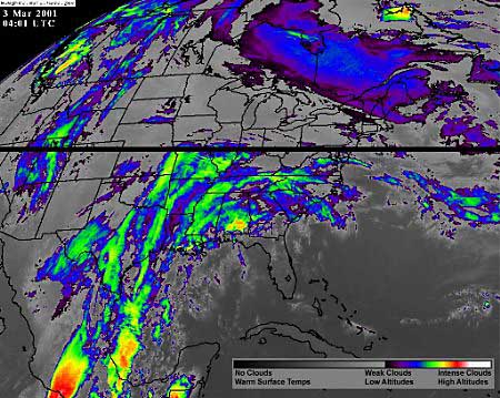 |
| From the Mid-Atlantic to the Northeast corridor, meteorologists were watching on March 2, 2001, for the formation of what could be the biggest snowstorm to hit the East Coast in decades, the National Weather Service said. This enhanced color infrared satellite image shows a low pressure system moving up from the Gulf of Mexico and 'a cold area' coming down from Canada that could combine in the Carolinas and create a severe snowstorm. The black bar is missing data from the satellite. (NASA via Reuters) |
| Page 2 |
| Home |
