The Rover Files Expedition Page

"Do it. Do it now. Whatever it is, don't wait until you have the time, or until you retire. Your "golden years" are not a reward for years of service; vacations are not prizes accorded to those who work the hardest. Instead, toil is a means to an end -- don't put off reaching that end if you don't have to. Success is doing what you enjoy, not having the resources to do it without the ability." ...Uncle Roger
On this page you will find photos and stories of my various weekend excursions, longer extended expeditions and other things of interest to all Land Rover owners.
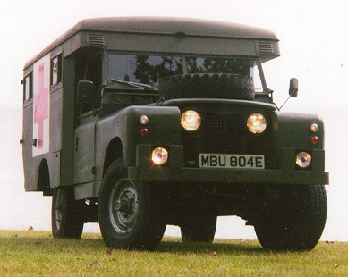
The First Expedition in the Ambulance!
The first excursion I made in my Ambulance was in early October of 1998. Myself and a friend set out on our annual hunting/camping trip to the coastal plain of North Carolina. I barely knew the vehicle and had only been driving it for about three weeks! But I had no need to worry as the only miss-hap that we had on the entire excursion was a leaky roof vent which I fixed by promptly climbing up onto the roof and tapeing up with duct tape! The below picture is of my Rover in a Sweet potatoe(Yam) field somewhere east of Raleigh, NC. Myself and my navigator had gotten a late start, and having driven until we were tuckered out we quickly decided on this remote agricultural field as our camping spot. This was the first time I camped in the old meat wagon!

The following pictures were taken on the north bank of the Pamlico River about 10 miles east of Bath, NC where we camp.
It sure is an imposing beast is it not?

Cades Cove Tennessee.
In early March of 1999, myself and two friends went to Cades cove to do some camping and wildlife photography. Cades cove is located in the south west quadrant of the Great Smokey Mountains National Park near the boarder between North Carolina and Tennessee(See inset map below for location). It is an area that is known not only for its friendly wildlife and grand scenery but also for its rich human history. You can get a frequently updated, semi-live, birds-eye view of the Cades Cove area of the park from the weather observation camera high atop Look Rock Tennessee by clicking:HERE
It is a grand place to spend some down time.

My comrade has a snack.

One of the things that you hope never happens!! On the way back to Boone after our camping trip the left front tyre was flattened by a rather large screw ...bollocks I say!!!

Spring 1999 Gulf Coast Excursion
In late may of 1999 myself and a friend set out on a 10 day road (and off-road) journey that would take us through many of the Southernmost States of the USA.
Day 01.
I started in my hometown of Boone, North Carolina, picked up my co-pilot/navigator in Asheville, NC and we headed west to Tennessee. We had plotted our course many weeks ahead of time but as always we were open for change and chance. We had no real schedule since you really can't with a Series Land Rover! On day one we made it to a small campground just east of Chattanooga, Tennessee(see maps below).
Day 02:
We dropped out of Tennessee into Alabama where we visited the National Aeronautics and Space Administration's Huntsville museum and Space Camp facility. Later that afternoon we checked out a very interesting native american Archaeological cave site in northern Mississippi. From there we pressed on and found a campground just inside the Mississippi state line where we endured our first thunderstorm--luckily just allot of rain with no tornados!!
Day 03:
We drove the entire length of the Natchez Trace Parkway in Mississippi. It was a leisurly cruise since the speed limit on all parkways in the states is 45mph. On the way, we stopped at several very interesting native american indian mounds. Upon arrival in Natchez, Mississippi--I pulled the Rover into a petrol station to ask for directions to a market. Mark and I hopped out of the Rover, I went inside to ask the clerk for directions and Mark went to call his girlfriend. I had not been inside for more than ten seconds when a man stuck his head in the door and said "is that your truck that's on fire?"--ON FIRE!!! The words sent a chill down my spine--I didn't even reply--I just ran out the door to find clouds of smoke billowing out from under the bonnet of my still running Land Rover!! I quickly jumped inside and shut it off--the cab was full of smoke! I grabbed the extinguisher and ran around to the front of the vehicle and raised the bonnet--smoke just rolled out--but there were no flames?!? It was then I realized the problem--the smoke had the distinctive smell of an electrical fire! I searched around and found that a wire that runs from a junction block behind the grille to somewhere in the engine harness had shorted against the horn mount and simply reverted back to its primal elements ie: carbon and smoke! The only thing left of the wire was just that--carbon, smoke and little lumps of what must have once been the actual copper wire! Since I was tired and hungry, it was late and we still had not re-supplied our food stores I did what any normal Series Rover owner would do in the same situation--I cut the remainder of the wire free, taped the ends off with electrical tape and--since everything still worked normally--we drove on! We finally found a market, some food and petrol so we then made a beeline for the Natchez campground just outside of town. Once there we had a nice dinner and turned in before 10pm.
Day 04:
After awaking and preparing to set out for the Mississippi river I found that the engine would not turn over? I made a quick check of the engine bay but found no obvious problems. As we were hungery and wanted to get on the road before it became too hot I opted to try the hand crank to start the beast. It turned over on the third spin of the crank---hhhmmmm??? We jumped in ahd headed out. our first destination before the river was the Emrald Mound National Historic site. It is a huge earthen temple mound--I believe it is the second largest in the USA--that was built by pre-historic Native Americans(more on the mound later). Below is a picture of the very impressive mound.

After touring the mound we took some time to make a quick track-rod end adjustment and prepared to get back on the Parkway. Unfortunatly the Warthog would not start---again!!! I noticed that the lights were still bright and the battery read 12v on the voltmeter--mighty strange! The battery was fairly new so I ruled it out. I then checked the battery leads--no corrosion there! I traced the starter leads to the button and then to the started--and there it was, a loose starter lead!! I tightenined it up and the old beast cranked right up! So we were off once again. Shortly, we crossed the Mississippi river (unfortunatly it was on a bridge--my Rover is not THAT amphibious) for the first time(and a first for both of us)--it really was not as wide as I thought it would be--but still an impressive site. After we crossed the river we were in Louisiana. We drove a few miles south along the Great River Road until we came to an area where, on one side of the road the farms seemed to streach off as far as the eye could see and on the other--the levee that keeps the mighty Mississippi from inundating the farmland with it's annual spring floods. We continued south for awhile until I saw a dirt road leading up the berm--I couldn't resist--so up we went! The road connected to another dirt track that ran along the top of the levee for as far as we could see! I decided to follow it. The drive along the top of the levee was slow but grand--as we drove we could see the River--which was in a low flood stage--off to the left and the farms to the right. The river was heavily traveled by boats and barges of all shapes and sizes. Many of the farms had multitudes of crop dusting light-aircraft swarming above them like bees--it was quite a site! I couldn't resist the urge to take a couple of side roads that led off into the riparian habitat next to the river. we stopped for a rest at this nice spot below.

Further downriver we drove through a small community of shantys built on flimsy stilts up to approx. 15 feet above the ground!! I also crossed a couple of flooded roads-see pictures below--but unfortunatly we never saw any Alligators! (If you like Alligators and other animals then check out my Wildthings page by clicking:HERE)
. We then ascended back up onto the levee where we met a HUGE piece of farm machinery! After squeezing past the behemoth, we continued south.
In the next six pictures you can follow the Warthog as she wallows across a flooded road--just a stones throw from the Mississippi river--somewhere in Louisana!


MAPS of the Gulf Coast Excursion with other locations that I have spoken about.
The first map is of the North American continent. Our journey took place within the area in the inset red box.

This next map is an enlargement of the inset area with our route highlighted in purple. The yellow points are where we camped. The blue/gray area in the Southern Appalachian Mountains is the Great Smoky Mountains National Park--where Cades Cove is located. The yellow box on the coastal plain of North Carolina is surrounding the region known as the Outer Banks--a very beautiful and special place to me. I have also indicated the town of Boone, NC that I currently call home. If you would like to see a nice "earth from space" photo with the location of Boone and it's relation to the rest of this side of the World click::HERE)

This is the legend for both maps.

I will have more on the Gulf Coast excursion in the near future.
To go to the Expedition Page Two--Click:HERE
Please, if you have any questions, comments or feedback just let me know by signing my guestbook below--thanks!


