
1. Grant 31222, Mecklenburg NC, ent. 9 Aug 1779, sur. 8 Mar 1780, iss. 22 Oct 1782. Issued to William Waddington, being 50 acres of land on the south side of Rocky River. The metes and bounds are: from a Beach (at the bank of said river) south 47 east 30 to two b. o. (Robert Davis’s beginning corner of a new survey), (with his line) north 80 east 59 to large pine (Davis’s other corner), (with his other line) south 50 east 60 to b. j. (on said line, (with his and James Love’s conditional line) north 26 east 40 to w. o. sapling, north 12 west 36 to b. o. sapling, north 53 west 9 to r. o. sapling (his own old corner on the bank of a small branch ) with or near his own line) north 77 west 111 to stake, then to begin. CC: William McAnulty, Charles McKindley.
2. Grant 3598, Mecklenburg NC, ent. Jan 17 1785, sur. 3 Apr 1786, iss. 7 Aug 1787. Issued to Archibald McCurdy, being 7 acres on the south side of Rocky River. As written in the survey warrant, this small tract “joined the land he bought of James Love joining Samuel Waddington’s land including vacant land between the plantations.” The metes and bounds are: from a big w. o. (by the turn hole and his own old corner), (up the river) north 88 west 20 to p. o. (Samuel Waddington’s corner), (up the said line) south 44 west 30 to b. j., south 38 east 36 to pine (by his own old line), then (along his line) to begin. CC: Adam Watson, William Bolch.
3. Grant 3167, Mecklenburg NC, ent. 25 Feb 1779, sur. 17 Mar 1780, iss. 22 Oct 1782. Issued to James Love, being 180 acres on the “west side of Rocky River”. A “swirl hole” is located near western boundary of this land where it intersects Rocky River. The eastern end is near a ford that crosses the river. The metes and bounds are: from a large w. o. (near William McAnulty’s land) north 23 west 59 to a w. o. sapling (near Waddington’s line), north 7 east 124 small pines (on river bank at swirl hole), (Down river as it meanders to a w. o. near a the Ford), south 31 east 100 to S.
Deed 14-88, Mecklenburg NC, 24 Oct 1788, prv’d Jul 1792. John Love and wife Elizabeth to John White. Two adjoining tracts totaling 330 acres were conveyed. The written metes and bounds identify this as being the same land as grant #3640. The other piece of land is a 30-acre portion of grant lying north of Rocky River (see section A in grant # 3224 below). Wit: James Ross, Archibald White.
4. Grant # 3741, Mecklenburg NC, ent. 28 Nov 1785, sur. 4 Feb 1786, iss. 26 Nov 1789. Issued to Archibald McCurdy, the warrant to survey describes the land as: “on the s. and east side of the plantation he bought of James Love on the open line joining Charles McCommon, Charles McKinley, and William Mcanulty.” The metes and bounds are: from a s. o. (his own old corner) north 31 west 100 to small w. o. (on the bank of the river), east (down the river) 88 poles to two hic. and p. o. (on the bank of river), south 41 east 30 to p. o., south 7 east 54 to p. o. (Charles McCommon’s corner), (with his line) south 30 east 52 to pine ( by said McCommon’s corner), south 42 east 72 to b. j. (by the Big Road), south 30 west 34 to b. o. (on the road), (along William McAnulty line) north 70 west 140 to a black (near his own old line), then to begin. CC: Luke Vickery, Joseph McCommons.
5. Grant # 475, Mecklenburg NC, ent. 16 Jul 1811, sur. 1 Oct 1814, iss. 29 Nov 1815. Issued to John S. McCurdy, being 30 acres “on the south bank of Rocky River joining David Bradshaw, Isble Davis, William McNulty Dec., Joseph McCommons, and his own lands.” This tract fills gaps between grant number 3741, 3167, 3122, and 3613. The metes and bounds are from a hic. (on the river bank). South 18 west 109 to pine, south 17 east 58 to b. j. (on said Davies line), south 52 east 19 to h. (his own corner), south 61 east 22 to p. o. (said McAnulty’s corner), north 48 east 11 to h., south 74 east 215 to b. o., south 28 west 12 to two b. j. (on side of the wagon road), north 57 east 76 to w. o., south 67 west 40 to b. j., north 30 to h., south 85 east 34 to b. o., north 11 west 45 to b. j. (on sd. McCommon’s line), south 52 west 60 to b. j. (his corner), north 61 west 32 to (another corner), north 57 to s. p. (his other corner), north 70 west 32 to stake (on bank of river), 9up said river) north 61 west 42 to stake, south 41 east 30 to p. o., south 13 east 120 to stake, south 52 east 68 to b. j. (by the wagon road), south 30 west 34 to b. o., north 70 west 140 to b. j., north 44 east 107 to stake, south 65 west 173 to stake, north 23 west 59 to w. o., north 7 east 125 to two pines (on bank of river at Archibald MCCurdy’s old corner), up said river to begin. CC: William S. McC___, Jeremiah Right.
6. Grant # 48, Cabarrus NC, ent. 16 Oct 1793, sur. 25 Nov 1794, iss. 28 Aug 1795. Issued to Charles McCammond, being 36 acres on the south side of Rocky River. The metes and bounds are: from b. o. (his own corner (in Thomas Watson’s line on the Indian Path, running thence with said Watson’s line) south 41 west 64 to stake, south 23 west 21 to hic. sapling, south 81 west 45 to pine (in his own line), (with said line) north 50 east 80 to b. o. (the same course 20 poles) to stake (his old corner), (with his other line) north 39 west 100 to stake (on bank of said river opposite to a pine on the north bank White’s corner, (down the meanders of the river) to a w. o (on bank of river near the ford his own corner of the old survey), (with his own line) south 16 west 100 to hic. grub (his other corner, then (with his other line) to begin. CC: Charles Dorton, Charles McCommond.
7. Grant # 3119, Mecklenburg NC, ent. 1 Jun 1779, sur. 10 Mar 1780, iss: 22 Oct 1782. Issued to Charles McCammon, being 195 acres on the south side of Rocky River “opposite the mouth of Coldwater Creek.” The metes and bounds are: from a b. o. on Thomas Watson’s line near the Indian Path, running with the line) north 41 east 14 to hic. grub (said Watson’s corner), (with his other line) north 88 east 42 to two pines (Watson’s other corner), with another line of his) south 88 east 61 to a w. o. sapling (another corner of said Watson), (with another line of his) north 69 east 64 to b. o. (another corner of said Watson), north 10 west 64 to w. o. sapling (on bank of river), up said river to r. o. on bank, west 57 to b. o. sapling, north 24 west 48 to ash (on bank of river), up the river to w. o. and ash (on bank of river), south 16 west 100 to hic. grub, then to begin. CC: Charles Dorton, John Love. [Note the cut-out section of this tract where the lines exclude a cut-out section along the river. When plotted on the index map, points where corners of various tracts abut the Indian trail can be connected showing that the route of the path crossed within the cut-out section. Why? Though granted much later in 1824 as Cabarrus Grant # 584, we have to ask if it was previous owned. Or was there an Indian camp or burial ground located in this section. For some reason, this section was respected and not granted as part of Grant # 3119.
8. Grant # , Mecklenburg NC, ent. _____, sur. 18 Aug 1780, iss. ____. Issued to Thomas Watson, being 135 acres on the waters of Horse Branch. he metes and bounds are from two pines (his own and Charles McCammon’s corner, running then with McCammon’s line) south 88 west 42 to hic. grub (his other corner near the old Indian path), (with his other line) south 41 west 103 to b. o. (near said path near John Love) south 34 to b. o. sapling, south 54 east 100 to stake (near Charles McKindley), north 83 east 47 to large hic., south 60 east 86 (crossing two branches of the horse branch to a corner of the place he lives on) to a stake, (with his own line) north 108 to stake (his other corner, (with his other line) west 92 to stake (another corner of his), (with his own line) north 103 to begin. CC: John Love, Charles Dorton.
9. Grant # 3192, Mecklenburg NC, ent. 8 Jan 1780, sur. 18 Mar 1780, iss. 9 Oct 1783. Issued to Thomas Watson, being 150 acres “on both sides of Horse Branch including where he now lives.” The metes and bounds are: from an ash (near mouth of said branch) north 53 west 58 to b. o., (with Charles McCammon’s entry) south 69 west 64 to small w. o., (with McCammon’s entry) north 80 west 61to two pines, south 103 to stake, east 92 to stake, south 108 to stake, (with his and Mary McCracken’s conditional line, south 60 east 78 to pine, (with his and Charles Dorton’s conditional line) north 3 west 178 to small b. o., then to begin. CC: Charles Dorton, John Love.
10. Grant # _________________, Issued to Robert Davis, being 95 acres situated on Reedy Creek. The warrant to survey is for 95 acres “between his own field that’s on the Plum Branch and apiece of land that is disputed between Hugh Campbell and Joseph Bigger including the timber ridge.” The metes and bounds are: from a b. o. (his own old corner, running with his line) east 94 to p. o. & pine, (with Samuel Waddington’s entry) south 63 west 146 to b. o., south 35 east 26 to b. j., south 63 west 40 small b. o., south 35 east 34 to b. o., south 36 west 32 to b. j. (Hugh Campbell deceased corner, (with his line) south 48 west 38 to two small b. o. and hic. (on a road), (with said road) north 20 west 46 to p. o., north 35 west 20 to b. j., north 4 west 50 to b. j., north 16 east 40 to p. o., north 11 east 54 to pine (on or near his own old line), (with said line) south 53 east 52 to small b. o. and hic. (by the old corner), (with the old line) north 16 east 200 to stake, then to begin. CC: Andrew Cimens Davis, Alexander Davis.
11. Grant # 3135, Mecklenburg NC, ent. 25 Feb 1779, sur. 8 Mar 1780, iss. 22 Oct 1782. Issued to Robert Davis, being 100 acres on the waters of Rocky River. The metes and bounds are: from two b. o. (on or near his own old line running, thence with William Waddington’s Entry) north eighty east 59 to large pine, (with said Waddington’s entry) south 50 east 79 to hic. (at the head of a draft), south 116 to w. o. sapling & pine, west 94 to stake, then to begin. CC: Charles McKindley, William McAnulty.
12. Grant # 3052, Mecklenburg NC, ent. 2 Aug 1779, sur. 3 Mar 1780, iss. 22 Oct 1782. Issued to William McAnulty, being 156 acres on the waters of Reedy Creek. The metes and bounds are: from two b. j. (on the Indian path, running thence with Charles McKindley’s entry) south 30 west 132 to b. o., (with said McKindley’s entry) south 22 west 33 to b. o. (David McKindley’s corner), (with this line) north 58 west 66 to b. j. (near said McKindley’s other corner), north 45 west 127 to w. o. sapling, north 16 east 101 to hic. (near Robert Davis & James Love’s entries), south 61 east 106 to stake, then to begin. CC: Charles McKindley.
13. Grant # 3613, Mecklenburg NC, ent. 4 May 1779, sur. 3 Mar 1780, iss. 7 Aug 1787. Issued to Charles McKindley, being 200 acres on the head of Horse Branch. The metes and bounds are: from a w. o. (on the east side of the flint hill) north 177 (crossing Horse Branch) at 139 to small b. j., north 28 east 190 to w. o. saplings (In a small grassy hollow) south 54 west 81 to two small b. j. (on the side of the Indian path, William McAnulty’s corner), (with McAnulty’s line) south 30 west 132 to b. o. (said McAnulty’s other corner), (with his other line) south 22 west 33 to b. o. (David McKindley’s corner), then to begin. CC: Samuel White, William MCAnulty.
14. Grant # 139 Cabarrus NC, ent. 24 Mar 1780, sur. 17 Feb 1795, iss. 5 Dec 1798. Issued to Aaron Wallace, being 52 acres on the Horse Branch of Rocky River. From a small w. o. (Charles McCinley’s corner, running with his line, south 68 west 40 to b. j., north 38 to hic., south 85 east 32 to small b. o. (Thomas Watson’s corner, running with his line) south 54 east 100 to b. j. (his corner), north 83 east 38 to small pine (on Mary Armstrong’s line), (with her line)south 28 west 136 (crossing said branch) to small b. o. (her corner), north 80 west 3 to small b. o. (on said McCinly’s line), (crossing said branch) (along his line) to begin. CC: James Watson, David Watson.
15. Grant 3670, Mecklenburg NC, ent. 1 Jan 1787, sur. 15 May 1787, iss. 26 Nov 1789. Issued to Charles McKindley, being 21 acres situated on Horse Branch. The metes and bounds are: from a small b. o. (on his own old line and John and George McCracken corner, and runs with their line) south 76 east 54 to pine (said McCracken’s corner), (with his line) south 60 to b. j. (McCracken’s corner), (with their line) west 54 to a small b. j. (on his own old line), then to begin. CC: Aaron Walker, Charles McKindley.
16. Grant # 3219, Mecklenburg NC, ent. 6 Mar 1779, sur. 23 Mar 1780, iss. 9 Oct 1783. Issued to John & George McCracken, being 247 acres on both sides of Horse Branch, a Branch of Rocky River. The metes and bounds are: from a hic. (on Thomas Watson’s line, and running with said line) north 60 west 151 (crossing the branch) to large hic. (Watson’s corner), south 26 west 141 (crossing the branch) to b. o. sapling (on or near Charles McKindley’s line), south 73 east 60 to stake, south 81 to long b. j., west 58 to b. j., south 43 to b. j. (near Archibald White), east 214 to b. o. & w. o. (near Thomas Winchester), then to begin. CC: Samuel White, Joseph McCammon.
17. Grant # 3725, Mecklenburg NC, ent. 13 Mar 1786, sur. ---, iss. 26 Nov 1789. The warrant of land for “John McCracken described the land as “joining Thomas Watson, James Bledsoe, and the plantation that belongs to the orphans of Samuel McCracken, deceased.” The survey is John and George McCracken, being 50 acres on the waters of Horse Branch. The metes and bounds are: from a hic. (their own old station corner), south 56 east 40 to pine, north 65 east 60 to hic., south 13 east 50 to pine, (near Thomas Winchester’s line) south 40 west 128 to stake (on their own old open line about twenty pole from a small pine marked for a corner), then to begin. CC: William Speers, John McCracken. The shape of this tract, seen as an extension of grant #3219 above, offers a visual key that will later be used in understanding a complicated duplication of entries surrounding the same area. As shown in the break-out that follows, three tracts entered by different people overlap in ways hard to describe in words.
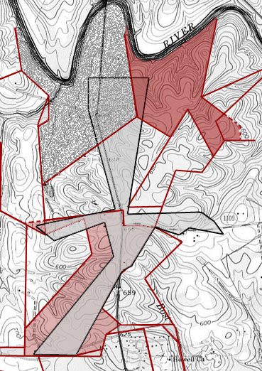
Concerning the sprawling gray tinted tract outlined in black. Issued to Charles Dorton. Though entered 15 years later than the tract above, this piece of 150 acres was issued and filed in the same shuck using the same file number s that above. Metes and bounds identify the western line of the northern portion of this tract as joining his old open line. Note how this tract overlaps the earlier entry known as grant # 51. And notice the notch cut out in the southwest side. Wrapping around lands of Mary, and later John McCracken, this shape clearly mates with grant # 3725. Nearly ten years after this tract was issued, you can see the same shape cut out of a tract issued to Jonathan Osborn. And though seemingly a bit wider, both tracts follow three nearly identical lines adjoining Jacob Smith to the east.
Concerning the light red tinted tract lying under the gray tract discussed above. Issued to Jonathan Osborn in 1804, this tract clearly encompasses a major portion of the same lands issued to Charles Dorton. In ________, Jonathan Osborn and Charles Dorton jointly sold the southern portion of this land to Christian Fogleman.
Concerning the darker red shaded area located on the south bank of Rocky River. Issued in 1814 to Silas Shinn and Samuel Morris, this tract overlaps Charles Dorton’s earlier grant (dark gray textured) and lies under his later grant (gray tinted). There is no later deed for this land in the name of Shinn or Morris
19. Grant #746, Cabarrus County NC, ent. 26 Feb 1853, sur. 22 Nov 1853, iss. 6 Apr 1854. Issued to Martin Boger, being 8 ľ acres lying on the south side of Rocky River “at the mouth of Horse Branch.” This tract matches perfectly the cut-out area in grant # 51 issued to Charles Dorton. The metes and bounds are: from a Pine (Boger’s own corner) north 11 east 122 to Stake (Darcus Dorton’s corner on bank of river), (up the meanders of the river) to Stake (on bank of river, Boger’s own corner), then south 65 east 16 to begin. CC: Martin Boger, Dan’l P. Boger.
20. Grant # 425, Cabarrus NC, ent. 3 Mar 1809, sur. 21 Jun 1809, iss. 18 Dec 1810. Issued to Silas Shinn and Samuel Morris, being a “plantation pr tract” of 245 acres on both sides of Rocky River. This is a unique plat in that surrounding land owners are drawn in and not just written in description. The metes and bounds are: from a stake by r. o (Biggers corner) south 20 east (crossing the river) to ash, (same course with Boger’s line) 140 to b. o. stump (Boger’s corner), (his other line) south 56 east 80 to pine (his other corner), (his line again) due south 40 to b. o., west 47 w. o. & b. j., south 25 west 32 to Stake (Charles Dorton’s corner), (with his line) north 35 west 90 to stake (his other corner), (with other line) south 15 west 130 to b. o. (his other corner), (with Jacob Smith’s entry) north 50 west 80 to b. o. (Dorton’s corner), (with his line) north 34 west 140 to hic. & w. o. on bank by the bank of river, cross river to a gum, then to begin (with Bigger’s lines). C.C.: ___________________, ______________.
21. Grant # 670, Cabarrus NC, ent. 18 Apr 1837, sur. 2 Nov 1837, iss. 26 Apr 1838. Issued to Alexander Dorton, being 75 Ľ acres on the waters of Rocky River. From a dead pine (William Watson’s corner, running with his line) north 6 west 75 to hic. (david Dorton’s corner), (with his line) north 58 east 117 to b. o. (Archibald H. Howell’s corner), (with his line) south 50 east 64 to b. o. (said Howell’s corner), (with Polly Dorton’s line) south 25 west 74 to b. j. (her corner), south 74 west 108 to begin. CC: Mare Dorton, Charles Dorton.
Grant # 51, Cabarrus NC, ent. 20 Oct 1794, sur. ---, iss: 28 Aug 1795. Note that this grant is not shown on the key map as it crosses over so many other tracts. Issued to Charles Dorton, papers for this tract of 150 acres are held and filed in the same shuck or envelop as the previous grant identified as grant # 51. The warrant to survey is for land on Rocky River “joining the following lands viz: in between Thomas Watson’s and Daniel Bogger’s lines and his own lines, also to John McCrackin’s and Barenhart Houseman’s lines, also to Isaac Breden’s lines joining the lines of the aforesaid persons lands wherever vacant.” The survey is for land on the south side of Rocky River and the waters of Horse Branch. Beginning at the western most corner and running south and east, the metes and bounds are: from a pine (Thomas Watson’s corner) south 50 east 18 to w. o., south 60 east 25 to pine (John McCrackin’s corner), (with McCrackin’s line) north 65 east 85 to hic. (his other corner), (with his other line) south 14 east 52 to pine (his other corner), (with another of his line’s) south 40 west 198 to b. o. (in Thomas Winchester’s line), (with said line) east 62 to p. o. (in said line), north 24 east 152 to pine, north 47 east 12 to small b. o., north 30 east 52 to pine (on side of hill), south 79 east 41 to b. j., north 48 east 14 to pine knot (in side of road & Barnhart Houseman’s corner), (with a line of his) north 56 east 8 to pine (said Houseman’s corner), (with another line of his) south 64 east 54 to b. j. (in houseman’s line), north 30 west 22 to pis.(in Isaac Breeden’s line), north 58 west 22 to small pine, south 86 west 64 w. o.(said Breeden’s corner), south 88 west 40 to w. o. (his own old corner), west 26 to stake (his other corner), with his open line (north 10 east 220 (running past the beginning corner) to stake, west 98 to stake, south 50 to stake (in the open line of his other survey), (with open line) south 18 east 160 to stake (a corner of said survey), south 78 west 90 to stake, then to begin. CC: Jacob Smith, Andrew Dorton. From the metes and bounds of this tract, it can be determined that the open line in the other tract in File 51 runs north 18 degrees west.
22. Grant # 327, Cabarrus NC, 17 Jan 1804, sur. ---, iss. 22 Nov 1805. Issued to Jonathan Osbourne, being 100 acres. The metes and bounds are: from a pine (Jno. Bradshaw’s corner) south 49 east 52 to pine, (with three of said Bradshaw’s corners) north 63 east 83 to sas. South 15 east 52 to pine, south 42 west 138 to pine, west 68 to pine, south 5 west 52 to p. o., east 84 to pine, north 80 east 64 to b. j. (Green’s corner), north 12 east 40 to b. j., north 60 east 24 to hic., north 44 west 42 to b. j., north 24 east 60 to hic., north 47 east 12 to w. o., west 40 to hic., north 20 to stake, then to begin. CC: Joseph Howell, Hamilton Russell.
Deed 7 220, Cabarrus NC, 11 Jan 1810, prv’d Apr 1810. Christian and wife Polly (O) Fogleman sold 40 acres to Samuel Weddington. This was the land “divided from the tract of land of Christian Fogleman formerly belonged to Jonathan Osborn & Chs. Dorton. Wit: Rob’t C. White, Melcher Fogleman.
23. Grant # _____, Cabarrus NC, ent ___________________________. Issued to Jacob Smith, being 50 acres on the south side of Rocky River on Lick Branch. From 2 ashes (on the Lick Branch) west 85 to stake, north 44 west 42 to stake, north 24 east 65 to pine, north 44 east 12 to b. j., north 30 east 52 to pine, south 79 east 49 to b. j. (in his own old line), south 44 west 65 to stake, then south 32 east 104 to begin. CC: John McKracking, Charles Dorton.
24. Grant # 05, Cabarrus NC, ent. 12 apr 1787, sur. 18 Feb 1793, iss. ---. Issued to Samuel Waddington, being 100 acres on the waters of Reedy Creek, a branch of Rocky River. The warrant to survey is for land “bounded by Robert Davis on the north, Will McAnulty on the east, David McKindley on the south, Robert Campbell on the so. West, and Joseph Spears. The metes and bounds are from a b. j. north 45 east 40 to p. o., east 26 to b. j., (along John McKinly’s line) north 55 east 82 to b. j., (with said McCinly’s line) north 36 east 60 to d. w., (near William McAnulty’s line) north 36 west 74 to pine (Robert Davis corner), (with his line) south 63 west 146 to p. o. (his corner), (with his line) south 35 east 26 to b. j. (said Davis’s corner), (with Davis line) south 63 west 32 to small b. o., south 35 east 86 to begin. CC: William McAnulty, David McCinly
25. Grant # 23, Cabarrus NC, ent. 12 Jun 1787, sur. 20 Feb 1793, iss. 9 Jul 1794. Issued to John McKindley, being 32 acres on he waters of Reddy and Anderson Creeks. The metes and bounds are: from a pine (David McCinly’s corner, running with his line) south 47 west 108 to r. o. , (with said line) south 58 west 83 to stake (near said McCinly’s old corner, (by his line) south 46 east 84, to stake by his old corner), (with said line) east 100 to hic., south 24 west 48 to b. j. (Joseph Bigger’s corner), (with said line) north 75 west 38 to b. j., west 44 to b. j., north 34 to s. o. (Bigger’s corner), with said line) north 46 west 84 to hic. (his corner), north 50 west 20 to b. j. (Samuel Waddington’s corner) (with his line) north 45 east 40 to p. o., east 26 to b. j., (with Waddington’s line) north 55 east 82 to b. j., north 36 east 60 to d. w. (Waddington’s corner), then to begin. CC: Samuel Waddonton, William McCinulty
26. Grant # 3174, Mecklenburg NC, ent. _______, sur. 10 Apr 1780, iss. _______. Issued to David McKindley, being 228 acres on the head waters of Anderson Creek. The metes and bounds are: frpm a b. o. north 58 west 60 ( with William McAnulty’s entry) to small w. o., south 65 west 55 to pine, south 47 west 108 to r. o. (on the Indian path, south 58 west 83 to hic. , south 46 east 84 (with Hugh Campbell & Joseph Bigger’s entry) to s. o., east 126 to long b. o. , north 62 east 109 to w. o., north 18 east 60 to small b. o. (by a pond), with Charles McKindley’s entry) to begin. CC: Samuel White, Charles McKindley.
27. Grant # 3137, Mecklenburg NC, ent. 20 Feb 1779, sur. 6 Mar 1780, iss. 22 Oct 1782. This tract was entered in 1779 by Hugh Campbell. Indicating Hugh died ca. 1780, the survey was made that year for 109 acres to be issued to “Robert Campbell, son of Hugh Campbell Late Dec’d.” Being situated on Reedy Creek, the metes and bounds are: from a w. o. (John Cromwell’s beginning corner near the Poplar Spring Branch, running with Cromwell’s line) south 40 east 88 to stake (in said line), (with his and Joseph Bigger’s conditional line) north 30 east 76 to w. o. sapling, (with said conditional line) north 53 ˝ east 23 to b. o., (with conditional line) north 35 east 73 to b. j. sapling (on David McKindley’s line), with said line, north 46 west 28 to hic. (said McKindley’s corner), north 64 west 82 to b. j., south 49 west 65 to b. o., then to begin. CC: Alexander Lewis, John Campbell.
28. Grant # 3051, Mecklenburg NC, ent. 2 Apr. 1779, sur. 6 Mar 1780, iss. 22 Oct 1782. Issued to Joseph Bigger, being 190 acres situated on the waters of Anderson Creek. The metes and bounds are: from a stake (John Cromwell’s corner on Francis Newell’s line, running then with Cromwell’s line) running north19 west 80 poles to w. o. (his other corner), (with his other line) north forty west 28 to stake (on said line Hugh Campbell’s corner), (with Campbell’s line) north 30 east 76 to small w. o. (his other corner), (with his other line) north 53 ˝ east 23 to b. o. (another corner of his), (with another line of his) north 35 east 73 to small b. j. (on David McKinley’s line), (with said line) south 46 east 56 to r. o. (his corner), south 48 to r. o. sapling, east 82 to stake (on his own line), (with said line) south 12 west 96 to large white (his own corner of the place he lives on), (with his other line) east 88 to stake (on said line), south 49 west 114 to stake (on Francis Newell’s line), (with said line) north 15 west 102 to stake, then to begin. CC: William Newell, Alexander Lewis.
29. Grant # 3053, Mecklenburg NC, ent. Sep 1779, sur. 3 Mar 1780, iss. 22 Oct 1782. Issued to Joseph Bigger, being 200 acres situated on Anderson’s Creek and includes “the improvement where he lives.” The metes and bounds are: from large w. o. ( a corner of Francis Newell, running then near Newell’s line) east 163 to small b. j. sapling (on Thomas Stuart’s line), (with Stuart’s line) north 29 east 68 to w. o. (Stuart’s corner near the bank of the creek), (with his other line) north 42 east 86 (passing Stuart’s corner hickory 36 poles) to small hickory, (with Samuel White’s entry) north 57 west 73 to b.j., (with White’s entry west 25 to w. o. sapling, (again with White’s entry) north 65 west 47 (crossing a small branch) to hic. Grub, south 85 west 88 to hic., then to begin. CC: _____________________, _______________________
30. Grant # 3156, Mecklenburg NC, ent. 16 Aug 1779, sur. 4 Mar 1780, iss. 22 Oct 1782. Issued to Archibald White Senior, being 128 acres on the waters of Anderson Creek. The metes and bounds are: from a b. j. (on the south side of the flint hill) south 20 east 120 to small b. j. (said Archibald White’s & Stuart corner of the plantation he lives on), west 112 to small hic. (Joseph Bigger corner), (with Bigger’s line) north 57 west 73 to b. j. grub (his other corner), (with his other line) west 25 (crossing a small branch) to two small w. o. (another corner of his), (with another line) north 65 west 47 to hic. Grub (another corner of said Biggers), north 18 to pine, north sixty east ninety (near David McKindley) to b. j., then to begin. CC: Samuel White, Archibald White Junior.
31. Grant 3123 Mecklenburg NC, ent. 25 Feb 1779, sur. 28 Feb 1782, iss. 22 Oct 1782. Issued to Francis Newell, being 308 acres on both sides of Anderson’s Creek near the Golden Spring. The metes and bounds are: from a w. o. (Thomas McFadon’s corner near the Golden Spring, then with McFaddon’s line) north 82west 55 to r. o. (McFaddon’s corner), (with his other line) south 85 west 78 to w. o. (his corner), (another of his lines) north 50 west 64 (crossing a branch ) to hic. (McFaddon’s corner), with another of his lines) south 64 west 20 to w. o. (on McFaddon’s line), (with Robert MCEachen’s entry) north 34 west 70 to b. j. sapling, (with McEachen’s entry) north 12 west 98 to b. o. grub, (with John Cromwell’s entry) north 58 east 97 to hic., (with Joseph Bigger’s entry) north 87 east 142 to w. o. and b. o. saplings, (with William Newell’s entry) south 15 east 76 to w. o. sapling, (with William Newell’s entry) south 17 east 56 to w. o. sapling, (with William Newell’s entry) south 8 east 84 (crossing the creek at 53 poles) to r. o. , then to begin. CC: Robert MCEachen, William Newell.
Deed 14-212, Cabarrus NC, 28 Jan 1837, prv’d Jan 1840. William Newell (Trustee of Seneca Turner) to Green H. Swearinger. As marked off on the plat above, this 80-acre parcel is situated west of the red dashed line in William Newell’s tract. It appears to also be a portion of the Coble purchase. Wit: Wm. H. Archibald, Dan’l A. Penick.
Deed 4-27, Cabarrus NC, 8 Mar 1797, prv’d Apr 1801. John Stewart to Charles McKindley. Being 53 acres situated on the west side of the creek and north of the red dashed line drawn in the plat above. The parcel is described as being “divided from John Stewart’s tract and taken from the west end of said tract.” Note that at the time of this conveyance, the point where the creek crosses the northern bounds of William Stuart’s original grant is known as “the bank of Bigger’s mill creek.” Wit: Samuel White. Jur: John White.
34. Grant # 3118, Mecklenburg NC, ent. 2 Aug 1779, sur. Mar 8 1780, iss. 22 Oct 1782. Issued to Archibald White Senior, being 300 acres situated on Anderson’s Creek. The metes and bounds are: from a long w. o. north 88 west 96 (with John Caldwell’s entry) to b. o. grub (on Caldwell’s old line), (with Caldwell’s line) south 72 west 42 (crossing his own spring branch) to b. o. (in his line), (with Thomas Stuart’s entry, north 22 west 38 to b. o., (with Stuart’s entry) north16 west 148 to small b. j., north 60 to b. j., north 76 east 53 to w. o., north 19 east 44 to b. o. and small pine, then to begin. CC: Robert McEachern, Hugh Campbell.
35. Grant # 299, Cabarrus NC, ent. 20 Jul 1802, sur. ---, iss. 13 Dec 1803. Issued to Archibald White, being 58 acres situated on Anderson’s Creek. The warrant to survey was for land “joining Peggy Green, John McClelland, and his own lands.” The metes and bounds are: from a stake (in his own old line) south 88 east 54 to a stake (his own old corner), (with his own old line) north 61 east 38 to p. o. (his own old corner), north 17 west 190 to b. j., north 47 west 10 to pine (his own old corner)
Concerning the grey rectangular shape. Issued to Russell Hamilton in 1812, the grey shaded tract lies on top of the same lands earlier entered by Thomas Winchester. If taxes for land are not paid, and if there is no buyer at the ensuing court ordered land sale, then the land would revert back to the state for reissuance. Though no record appears supporting that this happened, in 1812 Russell Hamilton was issued a grant encompassing lands earlier owned by Margaret Green.
Concerning the land outlined in bold black lines. Deed 10-196m Joseph P McGillicutty sold to Andrew Carriker the lands outlined in bold black lines. This shape included and mimicked that first owned by Thomas Winchester. The tract now encompasses a small entry to the east made by William Hamilton in 1805. I have yet to find land records indicating when or how William Hamilton lost control of the land.
Deed 1-62, Cabarrus NC, 19 Oct 1793, prv’d ---. Henry (H) Cagle to Margaret Green. being 120 acres “including Thomas Winchester’s old improvement and being an entry of said Winchester’s.” Wit: Wm. Polk. Jurat: Joseph Howell.
Deed 10-186, Cabarrus NC, 20 Mar 1823, prv’d Apr 1824. Andrew Karricker to William Bost, now containing 368 acres situated on the Lick Branch, being the lands outlined in black as discussed in the preceding cut-out. This tract includes Winchester’s grant # 3301, as is overlaid by Hamilton’s grant # 470, and further encompasses Hamilton’s grant # 471 to the east. Wit: Geo Little, Polly Little
Deed _46, Cabarrus NC, 6 Feb 1829. John Black, Martin Boger, and James White divided the “lands of William Bost amongst the heirs at law.” The tract outlined in black was divided horizontally into four tracts (see red dashed line in the overlay). The northern tract was given to Jackson Bost. The next tract to the south was given to Wilson Bost. The next tract was given to William Bost. The southern most tract was given to Caroline Bost.
38. Grant # 471, Cabarrus NC, ent. 18 Jan 1814, sur. 8 May 1814, 28 Nov 1814. Issued to Russell Hamilton, being 23 acres situated on Rocky River and joining Joseph Howell and Jacob Smith. The metes and bounds are: from a s. o. (bank of a branch, said Howell’s corner) south 50 west 43 to small pine (in his own old line), (with said line) north 12 west 177 to ash (his own and said Smith’s corner) south 37 east 54 to small pine (Howell’s corner), east 18 to s. o. (Howell’s corner), south 5 west 24 to pine, south 39 west 22 to pine, south 41 east 19 to p. o. (on creek bank), down courses of creek to begin. CC: Jacob Smith, Joseph Howell.This tract was later acquired by William Bost who then sold it to Andrew Karriker. As is identified in the overlay, this land makes up the eastern bounds of the tract outlined in black.
39. Grant 464 Cabarrus NC, ent. 18 Jan 1814, sur. ---, iss. 28 Nov 1814. Issued to Joseph Howell, being 5 acres on the south side of Rocky River joining Russell Hamilton and his own lands. Metes and bounds are: from a s. o. (on branch bank, his own and Hamilton’s old corners) north 14 west 10 to s. o. (his other corner), south 5 west 24 to pine ( Hamilton’s corner), south 37 west 22 to pine, south 41 east 19 to p. o. (on bank of the Lick Branch), down said branch to begin. CC: Jacob Smith, Russell Hamilton.
40. Grant # 289, Cabarrus NC, ent.20 Jul 1803, sur. ---, iss. 13 Dec 1803. Issued to John McClelland, being 58 acres lying on the waters of Anderson’s Creek. The metes and bounds are: from a w. o. (Arch’d White’s corner, then with said line) north 88 west 40 to pine (Jno. McClelland’s corner), (with his line) south 53 east 68 to r. o. (his own corner), (with his line) north 73 east 70 to p. o. (his other corner in a hollow), north 6 east 18 to pine, south (actually north) 37 west 28 to pine, formerly a hic. ( Archibald White’s beginning corner), north 90 to stake (said White’s corner), north 88 west 54 to stake (in said White’s line), then (with said line) to begin. CC: Archibald White, Thos. McClelland
41. Grant # 277, Cabarrus NC, ent. 19 Jan 1802, sur. ---, iss. 19 Jan 1802. Issued to John Howell, being being 59 acres on both sides of the Lick Branch. From a small p. o. (Margeret Green’s corner), then nmorth 10 west 25 to pine knot, north 51 east 50 to hic. (on bank of said branch), east 40 to pine, south 9 west 90 to hic. (James Love’s corner), (with his line) south 20 west 40 to pine, north 75 west 70 to b. o. grub (in A. White’s line), (with said line) north 13 to b. o. (his corner), south 70 west 160 to p. o. (his other corner), north 64 ˝ east 202 to begin. CC: Jonathan Osborne and Henry Howell.
42. Grant # 3732, Mecklenburg NC, ent. 18 Nov 1785, sur. 27 Feb 1787, iss. 26 Nov 1789. Issued to Archibald White, being 100 acres situated on the waters of Anderson’s Creek.
The metes and bounds are: from a hic. (by Adam Eager line) north 90 to stake, north 61 east 38 to p. o. (George “Bladshaw” Bledsoe corner), (with his line) north 70 east 160 to small b. o., south 80 to stake, then to begin. CC: Adam Eager, Archibald White.
43. Grant # 563 Cabarrus NC, ent. 30 Mar 1822, sur. 5 Sep 1822, iss. 13 Sep 1822. Issued to John White Senr., being 31 acres “of vacant land on the waters of Anderson’s Creek.” The metes and bounds are: from a small hic. (James W. Morgan’s line and a corner of Sally P. McClelland) west (actually east) 20 to p. o. (a corner of said Morgan’s and on John Carother’s corner), north 6 west 12 w. o. (John Carother’s corner), east 158 to stake (a corner of sd. Carother’s & on James Love’s line), north 53 west 82 to w. o. (on his own line), south 65 east (actually west) 130 to b. o. (his own corner), then to begin. CC: John Clay, Josiah P. White.
44. Grant # 3126, Mecklenburg NC, ent. 2 Aug 1779, sur. 28 Feb 1780, iss. 22 Oct 1782. Issued to Thomas McFaddon, being 133 acres adjoining the Barony line on the waters of Anderson’s Creek. The warrant is for land adjoining “John Dickson, Francis Newell and including the Golden Spring.” The metes and bounds are: from a w. o. (on the Barony running with Wm. Newell’s entry) north 14 to b. j., (with said Newell’s line) north 16 west 18 to b. j., south 75 west 38 to w. o., (with Francis Newell’s entry) north 82 west 55 to r. o., (with said entry) south 85 west 78 to w. o., with said entry) north 55 west 64 (crossing the creek) to hic., (with Robert McEachren’s entry up said creek) south 55 west 5 150 to hic. grub (at head of spring in the old field) south 29 east 35 to stake (on bank of small branch on the Barony line), then to begin. CC: Robert McEachren, James Black.
Deed 8-56, Cabarrus NC, 18 Feb 1805, prv’d Oct 1811. John McDowell of Abbeville County SC to Archibald McLarty. This is twelve acres “granted to Hanah McFaddon by a sheriff’s deed and from her to John McDowell by a deed of conveyance.” This tract (outlines in solid red) adjoins the dower land and is south of grant # 3126. Wit. Robert Griffin, Daniel Sossamon. Jurat: John McClellan.
Loose Estate Record, Cabarrus NC, 26 Nov 1799. Division of the dower for Hannah, widow of Thomas McFaddon Dec’d. As is outlined in red dashes, the northern corner of the dower was once part of Thomas McFaddon’s grant # 3126. The dower also nests within the U shape of deed 8-54 above. The metes and bounds are: from a w. o. (on the Barony line) south 18 east 66 to b. o., south 77 east 68 to stake, north 30 east 64 to stake (in pile of stones), north 55 west 31 to hic. (on road side), north 23 west 77 to b. o. sapling, then to begin. Committee to lay off land: Will’m McAnulty, Archibald White, Wm. Harris, Volentine Kirkpatrick, Sam’l McCurdy, David White, Robert Davis, John White, Samuel Waddington, Benjamin Cochran, David Taylor.
46. Grant # 105, Cabarrus NC, ent. 6 Jul 1797, sur. ---, iss. 7 Dec 1797. Issued to Samuel White, being 60 acres on both sides of the south fork of Anderson’s Creek. The metes and bounds are: from a large s. o. (his own old corner, running with his line) north 40 west 37 to a b. o. (his other corner), (with his other line) north 1 west 43 to p. o. (his & William Newell’s corner), (with said Newell’s line south 74 west 60 to large hic. (Newell’s corner), south 46 west 28 to pine, south 322 east 12 to b. j., south 42 ˝ east 100 (crossing the creek bank) to large pine, south 83 east 38 to p.o., north 57 east 110 to b. j., north 4 east 8 to stake, west 120 to stake, then north to begin. CC: Charles McKindley , Aaron Wallace.
47. Grant 3127, Mecklenburg NC, ent. 16 Aug 1779, sur. 2 Mar 1780, iss. 22 Oct 1782. Issued to Samuel White, being 80 acres situated on both sides of the middle and south forks of Anderson’s Creek. The metes and bounds are from a large s. o. (on south side of south fork) north 40 west 37 (crossing the south fork) to b. o. sapling, north 1 west 43 to w. o. (William Newell’s corner), (with Newell’s line) north 17 west 45 (Crossing the middle fork of sd. creek) to b. o. (his other corner),north 34 east 60 to w. o. sapling (William Stuart’s corner), north 83 east 32 to stake (his own old corner of the land he bought of John Caldwell), (with his other old line south 25 east 103 (crossing the middle fork of said creek) to b. o. (his other old corner), (with his other old line) south 40 east 40 (crossing the south fork of said creek) to stake (another old corner), then to begin. CC: Robert McEachern, Hugh Campbell.
48. Deed (not recorded, but accounted for as expressed in a later conveyance), 10 Feb 1765. Arthur Dobbs Esq. to John Anderson. Being 233 acres on Anderson Creek. This may very well be the man for whom Anderson Creek is named.
(west of red dashed line) Deed 2-342, Mecklenburg NC, 13 Dec Sep,prv’d _____. John Caldwell and Elizabeth his wife to Samuel White. Being 33 acres divided (west side of dashed line) from John Caldwell’s tract. The metes and bounds are from a stake (in the field above Samuel White’s house, running with the old line) south 25 east 103 (crossing the creek at 36 pole) to b. o. (said Caldwell’s other corner), (with another line) south 40 east 40 (crossing the south fork of said creek) to a bank (at the foot of a steep pine hill), north 7 west 160 (crossing the middle fork at 106) to stone (near a branch on said line), south 60 west 68 to begin. Jurat: John Carothers. . Note that the first line of this smaller parcel is the same as the last line of the larger tract it was cut from. The length of the line as described for the larger tract is 55 chains or 220 poles. Measured in poles, the same line in this small parcel is nearly half the length, being 103 poles. Note: based on this observation, and line measurements for surrounding lands, I have corrected the larger tract on the index map by drawing the shape as if one chain equals 2 poles. Jurat: John Carothers.
Deed 12-401, Mecklenburg NC, 23 Sep 1784, prv’d Oct. 1784. John Caldwell (farmer) and wife Elizabeth to William Edger and his son Adam. Being two tracts. With the expressed exception of the exclusion of 33 acres sold to Samuel White above, the first tract is 200 acres remaining from the land purchased of John Anderson. John Caldwell received the second tract as a Secretary of State land grant.
Deed 7-265, Cabarrus NC, 3 Jan 1798 prv’d _____. William Edger to John McLellan, being 96 acres (north of the red dashed line) on the fork of Anderson’s Creek. One of two tracts conveyed, this tract bounds Samuel White to the west and the dividing line between Adam and William Edger to the south. The northern portion of this tract was later included as part of land (15-463, Cabarrus) conveyed 28 Feb 1840 from David N. McEachern to Andrew Carriker. At that time, land descriptions indicate a road ran through the northern portion of the tract. Wit: John Newell, Charles McKinley.
50. Grant # 474, Cabarrus NC, ent. 18 Jul 1808, sur.---, iss. 24 Nov 1815. Being 125 acres issued to John Carothers. Joining John McClellan, James Love, and his own land. The metes and bounds are from a w. o. (his own and McLellan’s corner and with McLellan’s line) north 6 west 124 to pine (sd. John McLellan’s corner), east 152 to stake (on James Love’s line), (with his line) south 54 east 28 to pine (sd. Love’s corner), then south 44 west 86 to w. o. (in a branch), south 17 west 62 to b. o, (his own corner), then (with his line) to begin. CC: Archibald White, Thomas McClellan
51. Grant 396, Cabarrus NC, ent. 17 Jul 1798, sur. 17 May 1800, iss. 21 Dec 1801. Issued to John Corothers, being 16 acres on he north side of Anderson Creek adjoining his own and Samuel McGurdy lands. The metes and bounds are from a b. o. (his own corner) south 82 west 100 to s. o. (his other corner), (with his other line) south 51 west 56 to w. o. (another of his corners on McCurdy’s line), (with said McCurdy’s line north 18 west 22 to hic. (McCurdy’’s corner), (With another of McCurdy’s lines) north 45 east east 75 to w. o. (his own, Sam’l McCurdy’s, & John McClellan corner). (with his own old line) to begin. Samuel McCurdy, David Si___.
Deed 10-146 Cabarrus NC, 4 Jan 1824, prv’d ____. Moses Clay, John Clay, Hiram Brown, & Charles Townsend to William Bost.
Deed 20-229, Cabarrus NC, __________________. John Carothers to William Bost.
53. Grant # 3185, Mecklenburg NC, ent. 17 Aug 1779, sur. 22 Mar 1780, iss. 9 Oct 1783. Issued to Christopher Osborn, being 155 acres on both sides of Anderson’s Creek. The warrant to survey is for land “below John Coruther’s land and joining his own line on the other side and joining James Ashmore’s land.” The metes and bounds are: from a gum (his own old corner on the dividing line between tract number two & tract number five) north 40 west 28 (with John Carother’s line) to small w. o. (on said line), north 14 east 140 (crossing said creek) to stake, north 52 east 106 to small pine, south 14 east 248 to w. o. (by a water pond on or near his own line), then (with or near his own line) to begin. CC: Joseph Howell, Ephraim Barker.
6101 Ballou Court
Copyright © 2009 by George G. Thomas
2000 Tax Map for Cabarrus County

Land surrounding and to the west of present day Howell Baptist Church on Highway 601 has a complicated title history:
Raleigh, North Carolina
27609