
 |
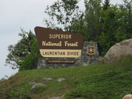
The sign at the left is an easy iindication one has reached
the Laurentian Divide. The divide is in a road cut about 4 miles north
of Virginia on Highway 53. In the roadcut it is easy to see the granite
part of the granite-greenstone terrane of northern Minnesota. The
greenstone (Ely Greenstone) is a particular name for a chlorite shist
metamorphic rock. The granite is part of a batholith. A batholith is a large discordant rock formation formed underground as molten rock cut across layers of pre-existing rock and slowly cooled. Because it cooled slowly, insulated by the ground above it, larger crystals of granite rocks were formed instead of the fine grained crystals of rhyolite. The Giants Range goes from just north of Hibbing (The "Hill of Three Waters" is in the Hull-Rust Mine) to Babbit and rises from 200 to 400 feet above the surrounding area. |
| The intrusions ("wavy" parts) and inclusions (more angled and
smaller parts) of the rocks combined with the metamorphic changes make
the geologic time table difficult to determine. Radiometric
determinations of the rocks place the time of formation about 2.6
billion years ago. About 1.8 billion years ago the Biwabik Iron
Formation was placed on top of these older rocks and then about 11,000
years ago glaciers left the landforms we see today. The lighter colored rock is called tonalite and the darker is diorite. Other dark more angular patches are metamorphosed volcanic or sedimentary rock that the grantitic magma intruded. Tonalite2 is a rock intermediate between granite and diorite (a different website than just above). For most people the differentation between tonalite and granite could only be made by chemical analysis of the minerals. |
 |
 |
 |
1.
Geology Plaque placed by the Minnesota
Geological Society, 1998


