
 |
The first view getting off the bus. Notice the large boulders as well as the very fine sand and about everything in between. The boulders are well rounded showing the amount of abrasion before they were deposited here. While the boulders have been piled here by the mine operators, the presence of both the large and small material is evidence of the lack of sorting that would occur in an outwash plain. In a situation of an outwash plain larger material would settle out first extending to smaller material as the velocity of the water decreased. |
| This is a sample of pillow basalt. Note the rounded patterns in the rock that indicate it was formed from lava that cooled quickly in the presence of water. The light colored stripe at the left of the rock is an intrusion of granite. This is a common occurrence in the basalt formations along the North Shore of Lake Superior. Rocks of this type indicate that they were moved here from the north east, the direction of the St. Louis Sublobe. |  |
 |
This photo is of a
large boulder
of mostly gabbro with intrusions of granite. Gabbro is large
grained
igneous rock formed deep inside the earth (intrusive) where cooling can
occur slow enough to form the large crystals.
The rock below right is a basaltic rock with granite intrusions, common in the Duluth Complex. |
 |
 |
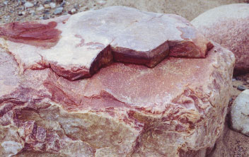
| The rocks above and right are quartzite, a metamorphic rock that is formed when sand (quartz) is pressed together with heat and pressure. A similar rock of orthoquartzite is a sedimentary rock that is cemented with silica. An example is Sioux Quartzite from southwestern Minnesota. Additional information on Sioux Quartzite will be at the end of this presentation. |  |
 |
This rock is a
metamorphic rock,
most probably Ely Greenstone. Just because it has "Ely" in the
name
doesn't mean that it came from Ely, MN. It is a classification of
metamorphic rocks that have outcrops at the surface in Ely but also
form
the bedrock of much of northern and northwestern MN. The bedrock
is folded into synclinal structures with granulite gneisses and is
crosscut
by granite. The Greenstone belts form linear trends from SW to NE
across much of northwestern MN. Komatiite is very distinctive of
the greenstone belts. It is a rock that is the volcanic
equivalent
of peridotite. It becomes liquid about 1600oC, a much higher
temperature
than the basalt (1400oC) that is released from volcanoes today.
The
greenstones also have a pillow formation. The Tower Soudan iron mine lies in these greenstone belts but all of the other mines that make up what is known as "The Range" were formed differently and is the subject of our next two stops. (Class notes from Dr. Kroeger) |
 |
The photo at the left is of iron
containing
rock. The iron bands (darker colored areas) are likely hematite
while
the reddish bands are jasper, a form of chert that contains iron oxides
to give it the reddish color. These are both forms of quartz.
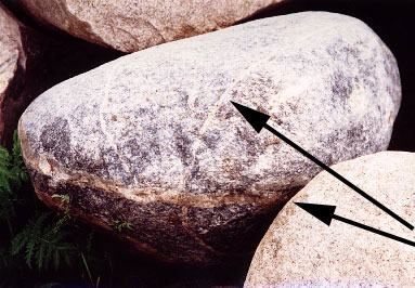
The rock at the right is an amphibole shist, also a metamorphic rock. This particular sample has a large intrusion of feldspar (the arrows). |
 |


