Don't think of it as an ad, it's more like a billboard...to enhance the downtown experience? Good excuse?
Back to General Info
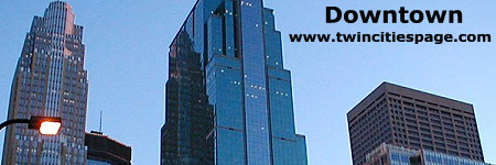
Minneapolis

Visual aids: Detailed downtown map | Downtown cores diagram | Diagram of downtown area | Huge overhead view (unlabeled) | Huge overhead view (labeled) | Height List
- Area : Downtown Minneapolis is located upstream from Saint Paul, huddling the Mississippi in the central part of the city boundaries (it is slightly north of center). Downtown Minneapolis is considerably larger than Saint Paul, especially since more people consider the downtown core to be fairly expansive. Downtown is often considered to be the area bordered by I-94 to the south and the Mississippi River to the north. While the east/west borders are not definite, most would consider 3rd Ave. N to be the western border since it runs next to Highway 394 and includes the Warehouse District. To the east, figuring in the Metrodome, the boundary would be at approximately 11th St, marking an area that covers around 2 square miles. With this set of boundaries, there are still complications, because north of I-94 lies the Elliott Park and Loring Park neighborhoods, adjacent but not included in the downtown core.
- Population : There is an official Downtown East and Downtown West neighborhood. Collectively, they hold only 4,709 people. Usually, when looking at Minneapolis, people consider the adjacent neighborhoods, including Elliott Park, Loring Park, North Loop, Steven Square, and sometimes the Nicollet Island and St. Anthony West neighborhoods across the river. If you could up all the neighborhoods together, the population count swells up to 26,815 in the downtown vicinity. With the exception of Steven Square, every neighborhood adjacent to downtown and in downtown itself has experienced growth since 1990, with the leader being Downtown East, increasing over 400% in the last 10 years.
- Accessibility : Being the largest city in Minnesota means downtown Minneapolis has the best accessibility in the metro area. I-94 approaches from the east, runs along the distant southern edge of downtown’s reach, then takes a turn and runs north, allowing it another run by downtown. Highway 394 comes from the western metro, straight up alongside the Warehouse District before ending onto Washington Ave., a major artery. Highway 35W also approaches downtown from the northeast, running along the eastern edge of the area, by the Metrodome, merging briefly with I-94 before splitting off to the straight south, dividing Minneapolis into two halves. Approaching from the south is particularly impressive since the view is great from here. Besides those highways, Minneapolis has a set of major roads, including Hennepin, Nicollet, Washington, Portland, and University on the other side of the river. Hennepin Ave. is one of Minneapolis?most historical and important roads. It is known as Laurpenteur Ave. in neighboring Ramsey County, becoming Hennepin once in Minneapolis, heading through downtown, and down south to the chain of lakes, stopping at Lakewood Cemetery, the city’s largest and most famous cemetery. In downtown, it is a major entertainment and cultural spot. Sleaze and award-winning theaters all blend together to become a focus of downtown energy. Nicollet Mall neighbors Hennepin briefly when starting at Washington Ave. It heads south, with a dozen blocks built for the pedestrian as it winds through downtown. After Nicollet Mall ends, Nicollet Ave. continues, heading straight south all the way into Bloomington, terminating along the bluffs of the Minnesota River, nearly 13 miles to the south. Portland Ave. is the third north/south thoroughfare that slices through the city, beginning near the Mississippi, and heading south to the far end of Bloomington, like Nicollet. The two most important east/west arteries are Washington Ave. and University Ave., north of the Mississippi. What is interesting is that Washington actually meets University and goes through the heart of the U of M, heading across the Mississippi through downtown and north, following the river into northern Minneapolis. University Ave. is perhaps the most important link between the Twin Cities. University begins near 35E northeast of downtown Saint Paul. Heading west, it heads through the entire west half of the city, veering at a northwest angle into Minneapolis, continuing along the north end of the U of M. Following the Mississippi, it runs parallel to downtown before following the river north into the deepest parts of Anoka County, miles to the north. Many of these, for the exception of Nicollet and Hennepin, serve as conduits for travel, little more. Only in a relatively small area of downtown is there a deep concentration of retail.
- Business Core : Minneapolis has one of the largest compilations of corporate towers in the state, many of which are used by huge companies like Wells Fargo, U.S. Bank, Pillsbury, AT&T, Piper Jaffray, Target Corp, Multifoods Corp., and American Express. Many of the top employers are all heavily concentrated in a small portion on downtown, between 3rd St. S and Nicollet (east and west). To the north and south it is difficult to impose limits, because that is where corporations like American Express and Target are expanding into. Roughly, it would be in between 5th and 10th Ave. S, but with Target Plaza North and South rising, the boundaries will expand again.
- Retail Core : Undoubtedly, the highest concentration of retail is found within a core of about 6 blocks, with Nicollet Mall making an extension to the south. City Center, Gaviidae Common, Crystal Court, Baker Center, and Northstar Center combine to form a group of nearly 400 stores, as many as Mall of America. Dayton’s and various other stores front along the northern three-fourths of Nicollet Mall, which adds greatly to the retail core. Every block is connected to each other via skyway. More retail opportunities surround this core, but not in the numbers this small area encompasses.
- Historical Core : The primary historical core is the Warehouse District, composing the northwestern part of downtown. It has a collection of old Warehouses and small commercial buildings, the ruins of what was an active place in the 1800’s and early 1900’s. The district does offer good shopping and cultural opportunities, but Warehouse District hasn’t stayed as well preserved as the Lowertown area in Saint Paul. Still, it is one of the few places in downtown where tall glass towers haven’t invaded. There is also a secondary core, but it doesn’t operate as one. City Hall and the Telephone Building make up the southern edge of this column of historical structures that heads to the river. This includes the Milwaukee Depot, Grain Exchange, Flour Exchange, and many old warehouses along the river that are being renovated into new uses. This is important enough to consider a second core, because it has a healthy concentration of buildings that remain well preserved.
- Cultural Core : In Minneapolis, this is quite difficult to define exactly. Definitely, Hennepin Ave. and the Warehouse District are the easiest places to mark. The Orpheum and State Theaters, two of Minnesota’s top attractions, front on Hennepin, along with a variety of cafes, bars, and sleazy entertainment. It is a street with much character, which attracts a diverse crowd. The Warehouse District contains a large amount of local theaters and trendy cafes. This can definitely be counted towards a cultural core, especially since it has the Target Center, highlighting sports culture. Orchestra Hall is nearby, yet another core in its own. Across the river, out of downtown, the historic St. Anthony neighborhood is the oldest in the city and makes a worthwhile cultural and historical core in its own.
- Major Buildings : Minneapolis has the 10 tallest office buildings in Minnesota inside its dense core. There are actually two towers locked in a tie for first place. Those are the IDS Tower, Philip Johnson’s 1973 masterpiece, and U.S. Bank Place, a 1992 experiment in glass geometry (done by a student of I.M. Pei). There is an unconfirmed statement that U.S. Bank Place may actually be slightly taller than records say, and was kept quiet as not to take away from IDS. Nevertheless, the two towers soar 775 feet above the ground, sharing the skies with a third tower. Only a mere foot shorter, Wells Fargo Center is a stunning art-deco beauty designed by Cesar Pelli. It was built in 1987 to replace the old headquarters that burned down in a disastrous 1982 fire. These three titans dominate Minneapolis together in a complementary trio. The fourth tallest building is the Multifoods Tower, part of City Center, an 80’s upscale mall, and cousin to Town Square in Saint Paul (designed by the same company, Oxford Properties). While bland and uninteresting to locals, its drastic height of 668 feet makes anyone seem small and timid. Piper Jaffray is the fifth tallest building, noted for its bright blue glass and stepped roof. It stands 572 feet tall. Pillsbury Center and Dain Rauscher Plaza are the only other two complexes to break the 500-foot mark. Minneapolis has many other noteworthy corporate towers. The two most recent entries are American Express and Target. American Express was formerly known as Investors Diversified Services (IDS!) and with the name change and new century rolling around, they decided to construct a new 1 million square foot tower next to U.S. Bank Place, complimenting it with a similar façade. Target Corporation is working on a new tower at the end of Nicollet Mall called Target Plaza South. It will expand the ever-growing collection of corporate towers in the city. AT&T is present here as well, building a huge glass tower commonly called the artichoke. Across the street is Minneapolis?most famous skyscraper, Foshay Tower. This 447-foot tall building is based off of the Washington Monument. Wilbur Foshay was a young man with a dream of building the ultimate skyscraper in Minneapolis, based off his favorite monument. Foshay Tower opened in 1920 in what seemed like a bright future for the broker. However, Foshay’s fortunes fell soon after, but the tower remains with his namesake and a huge obelisk that demonstrates that not all of yesteryear’s Minneapolis is gone. Besides the towers, there is a variety of other important attractions downtown. Alongside Nicollet Mall is Orchestra Hall, a modern home for the Minnesota Symphony and one of Minnesota’s top cultural buildings. The Metrodome and Target Center are two sports arenas, each flanking one side of downtown. While a Twins or Vikings game is going down in the Metrodome, the Target Center is having a Timberwolves game, or even the Minnesota Lynx (our WNBA team). Along Hennepin Avenue is the Orpheum Theater, perhaps the city’s most known. Minneapolis covers a variety of realms from business to entertainment.
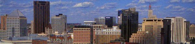
Saint Paul
Visual aids: Detailed downtown map | Lowertown diagram | Labeled skyline diagram (NEW!) | Downtown cores diagram | Diagram of downtown area | Huge overhead view (unlabeled) | Huge overhead view (labeled) | Height List
- Area : The downtown area occupies an area along the northern banks of the Mississippi in the south-central area of the city. It runs along the river for roughly a mile and extends north of the river for about two-thirds of a mile, making the downtown very compact. It is about eighty blocks extending form Kellogg Boulevard east to the edge of Lowertown at Broadway St, near the Lafayette St. Bridge that crosses the river, heading down to South St. Paul.
- Population : As of 2000, downtown proper had a population of 5,896, growing by slightly over 33%. Downtown is growing rapidly with the construction of many new condominiums and apartment buildings. It is the fastest growing neighborhood in the city by a wide margin.
- Accessibility : St. Paul is easily accessible by I-94 that runs east/west, connecting it directly to Minneapolis and many eastern suburbs. I-94 runs between the downtown area and the government campus. I-35E approaches downtown from the north, merging with I-94 at the northeast edge of downtown, and separating from I-94 at the western edge of downtown, veering southwest towards Mall of America and the International Airport. Robert and Wabasha streets run right through downtown and offer easy access from the south. Saint Paul is not incorporated well into the street grid. Many streets end near downtown or are completely cut off by the highways, which nearly makes downtown into an island. Only major streets run over I-94 or I-35W to connect downtown to the rest of the city. The only neighborhood that mixes with downtown is West Seventh (Pop: 10,412), which is anchored by the street of the same name, a rather minor road inside the core itself.
- Major Streets : There are relatively few major streets downtown. The area tries to keep the image of a more tight knit community, so the widths of streets are kept relatively conservative. The most important streets are Kellogg, Wabasha, and Robert. Kellogg approaches from the northwest, running by the Cathedral of St. Paul and the Minnesota History Center, down to the X-Cel Energy Center, and then curves off to run along the course of the Mississippi, on top of the bluff. It is downtown's widest street and most importantly a traffic corridor. Wabasha is downtown's premier shopping street. It starts right at the Soldier's Memorial on the capitol grounds, crossing I-94, heading south through downtown over the Mississippi and on to the south edge of the city (becoming Concord St. along the way). Wabasha has a collection of stores, most importantly Daytons, that runs along its course. To the east, Robert St. is much the same as Wabasha, only that it primarily serves as another traffic corridor. Beginning at University, the most important east/west street in the city, Robert heads south through downtown, marking the extreme western edge of Lowertown. It heads down through the southern side of the city, through West St. Paul and beyond into Inver Grove Heights, an extreme southern suburb. The city also has a collection of less vital, but important streets, including Cedar, E. 4th, and E. 5th. Cedar runs north/south through downtown and up alongside the capitol, while 4th and 5th run east/west, holding a majority of the street retail outside of Wabasha.
- Business Core : The business core of downtown could be considered in the shape of a square, bounded by Wabasha (west), Robert (east), E. 7th (north), and E. 5th (south). In these nine blocks, the heaviest concentration of business can be found, including Piper Jaffray, MN Life, Ecolab, Fifth Street Center (formerly Wells Fargo), and U.S. Bank. All nine blocks are directly connected to each other via skyway. This lies in the central third of downtown. To the east is the cultural center of downtown and to the west lies Lowertown, the residential and historical core of downtown.
- Retail Core : One can consider two commercial cores of the downtown area, both connected through Daytons at E. 6th and Wabasha. The street level commerce stretches along a three block stretch of Wabasha starting at E. 7th, where the Children's Museum sits, heading southward to E. 4th St. Seventh Place is an extension of this shopping area, a one-block arcade in between 6th and 7th. Daytons take shoppers inside to the skyway core of the shopping area. While World Trade Center and Galtier Plaza have lost the edge in retail, shopping opportunities still persist in Fifth Street Center (formerly Wells Fargo), U.S. Bank and Town Square. This makes an L shaped indoor shopping core. Stores are located throughout downtown, but these areas contain the highest concentration of stores, about 70-90 altogether (estimate).
- Residential Core : Saint Paul's downtown concentration is focused in and around Lowertown. Galtier Plaza, Kellogg Square Apartments and the Pointe of St. Paul are downtown's largest residential buildings. Galtier and Kellogg Square both sit in the realm of Lowertown, which has a high concentration of renovated apartments and condominiums. More modern projects like Mears Park Apartments, Essex on the Park, and the upcoming Sibley House are all being or have been built in Lowertown, solidifying its hold on the residential market downtown.
- Historical Core : The historical center of downtown can truly be considered Lowertown. A majority of the buildings date from the late 1800's and many have been preserved and renovated for modern use. The core of Lowertown is centered around Mears Park and to the immediate east of it. Lowertown takes up over 25 blocks, making up the eastern third of downtown. There is also another secondary core on the opposite end of downtown. Headlined by the Landmark Center, Rice Park is the city's oldest park and has such prestigious neighbors as the St. Paul Hotel and the Public Library/James J. Hill Reference Library, all nearly 100 years old. It has recently been hailed for the renovation of the Minnesota Club, a historic building, and the continued use of the old Roy Wilkins Auditorium, even though opponents clamor for a replacement.
- Cultural Core : The cultural core of downtown is Rice Park. The Ordway Theater, Landmark Center, and Public Library all border the park, making it an important front yard and gathering space for groups. It extends west to the Science Museum on the riverfront and east to the Children's Museum down E. 7th. The cultural core could be considered to extend up Kellogg to the Cathedral and Historical Society at the top of Summit Hill, marking a small core out of downtown. The capitol is a very important cultural building as well, so there is a nice distribution of cultural sites around the downtown area. Lowertown makes a good secondary center for downtown, especially around the Union Depot and Mears Park, where many small events pertaining to the arts take place, such as the annual Saint Paul Art Crawl.
- Major Buildings : The tallest building in Saint Paul is the World Trade Center at 470 feet. It is included in the business district of downtown and was formerly an important retail center. It has lost that distinction, but it is renovating its interior space into more business and office space. Galtier Plaza is the second tallest building downtown, reaching 443 feet into the air. It is a mixed-use project that was meant to headline Lowertown. It incorporated three historical buildings into its facade, and provided a large group of condominiums and apartments over a business/retail core. Much like the World Trade Center, its retail prominence has dropped considerably and has realized that office space currently provides a much more profitable commodity. The third tallest building is the First National Bank Building. This is a historic art-deco building, built at the start of the Great Depression. Its most noticeable feature is the 50-foot tall 1st sign at the top of the building. Even though the top of the rigging reaches above the World Trade Center to a height of 511 and 1/2 feet, it is not included in the height of the building itself. The height of the rigging is supposedly 100 feet, making the building 411 and 1/2 feet tall. The fourth tallest building downtown was formerly considered the Landmark Center near Rice Park. Actually, for many years, the height on the internet has been misconstrued, and recent checks into city records show it to be much shorter than thought. The fourth tallest building is actually the Pointe of Saint Paul, the tallest all-residential building in the city. It is 340 feet tall and sits at the extreme northern edge of downtown. The fifth tallest building, thought to be Ecolab, has also been proven to be shorter than expected. City records show that the fifth tallest building actually is U.S. Bank Center, which was built as the American National Bank Building. It is now the headquarters of Firstar Minnesota, and stands 338 feet tall. Other important buildings include St. Paul Companies (the city’s only remaining Fortune 500 Company), Kellogg Square Apartments, Ecolab Plaza, and the City Hall/Ramsey County Courthouse.
- Comments : Currently, Saint Paul is experiencing a residential boom. The Essex on the Park and Sibley House Apartments at the northern edge of Lowertown is currently under construction. The Sibley House Condominium Tower is slated to rise later this year, which will actually end up with extra stories added on to it because of popular demand. In Lowertown, the James J. Hill Warehouse is being renovated into new condominiums, adding more residential units to the area. By 2010, the city hopes to have 20,000 residents downtown. A streetscaping program is also making progress, currently closing part of Kellogg Blvd. to add a more aesthetically pleasing look. The only other large project going on is the building of a new parking ramp called the Capital Center Plaza. This will add about 900 reserved spaces to the downtown parking scene, leased in monthly contracts to employees. It will also form an important skyway link, finally creating a third loop in the system. Office space is being added to the World Trade Center and Galtier, which has been met with success so far.
Back to General Info