Index Dutch Bronze Age
Index first farmers in the Netherlands
Deze pagina is er ook in het Nederlands
Friesland in the time of emperor August
The North of the Netherlands was probably Teutonic during the reign of the Roman emperor August en was only partly inhabited by means of the influence of sea and swamps.
The map below is a probable view on various places and tribes from about 2000 years ago, as people in the Middleages thought. Under the map are some remarks by Rik Eckhart (to whom I owe my gratitude for his contribution and research) and also by me.
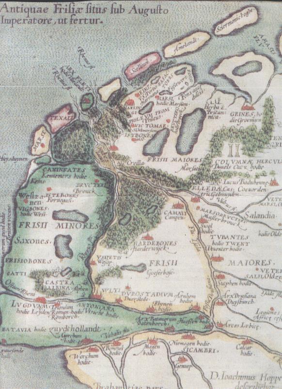
Remarks by Rik Eckhart:
- "I thought this map has been a fraud until I read this spring (2004, H) that dendrochronolic research proved that the 'Roman' schips from Woerden and de Meern have been made by Dutch Oaks, just after 150 C.E.."
- "When he (= Abraham Ortelius) took in a new map in the 'Theatrum' in 1579, he inserted also his first historic map of the Netherlands in ancient times: 'Antiquae Frisiae Situs sub Augusto Imperatore, ut fertur' (The seat of ancient Frisia under Emperor Augustus, as has been supposed). At first he didn't know who was the original author of that map (he adds "ut fertur" to its title), but in 1593 he found out that Joachim Hoppers, a Fries and high official in the reign of Charles V (1519-1555), was the author."
- But the fact remains that that map was probably a copy of an original which in fact was much older.
Remarks by me:
- I found out that the copy of the map has been made in 1579 (See Orteliusmaps http://www.orteliusmaps.com/images/5044.htm and http://www.orteliusmaps.com/stocklists/fullstock.html#Low_Countries,_17_Provinces )
- The other name for Utrecht, Antoniana, is remarkable. This makes me think about Constantinopel which first was called Byzantium and later was renamed after emperor Constantine. And Lelingrad/St. Petersburg. Was it simply renamed by a devoted consul of the Romans after emperor Antonius?
- Sicambri is the name of the tribe that lived near Nijmegen, not another name for Nijmegen.
- Columnae Hercules: this name is located near the palce where once stood a Bronze Age temple (Bargeroosterveld). This was een small (± 2,50 m. x 2,50 m. x 2,50 m.) wooden structure, found in a swamp near a place where swamp iron ore had been found, in the province Drenthe.
- "hodie": this name is added after many names of cities and comes from the Latin for "Present/today". It may indicate that the author in the Middle ages used the name that was common at that time.
- "bones": this is also a strange word with an unknown meaning.
- Zeeland is missing on the map. Is that because of the large Elizabethsvloed (a flood which flooded large parts of the SW Netherlands) somewhere in the 14th century?
- The name "Castra Albina" stands for the Roman castellum that was located in Alphen a/d Rijn at that time.
- The Caninefatae or "onion-lords" lived -from my point of view- more south because onions can't be grown in the old sea clay (North-Holland) but indeed in the South-Holland sand near Leiden, Noordwijk and Lisse. The area where dutch tulips grow nowadays.
- The map hasn't been changed during the copying in the 16th century, because Dordrecht fails. Dordrecht was an important city since the 13th century.
- The map was changed during the copying in the 8th century, because for example Durostadium / Wijk bij Duurstede was filled in. A place that was sacked by the Vikingers around that time.
Remarks of a specialist of Cartographica Neerlandica:
- "The map ... is a part of Ortelius' Frisia Occidentalis
and pretends to give a view over Friesland during the reign of emperor
August, but it is in fact a reasonable view over Friesland of about 2000 years B.C.E.,
so 4000 years ago.
There is more about West Friesland and this extra map on my website." - Rik's remarks on this:
"4000 years ago seems really far back. My motivation to the authenticy of this map is the fact that it shows high trees in the area of the IJsselmeer and below Texel. That seems unbelievable and Ortelius doens't repeat that in his own, later maps, but appears to be correct after all." .... "what happens when you take down 40 meter high oaks and make boats of them? The swampy land will loose its soil by erosion and will eventually get overflooded by the sea. That way the IJsselmeer formed and the islands (Waddeneilanden) changed their location" (in opposite to their original location, H).
Of course your remarks are very welcome.
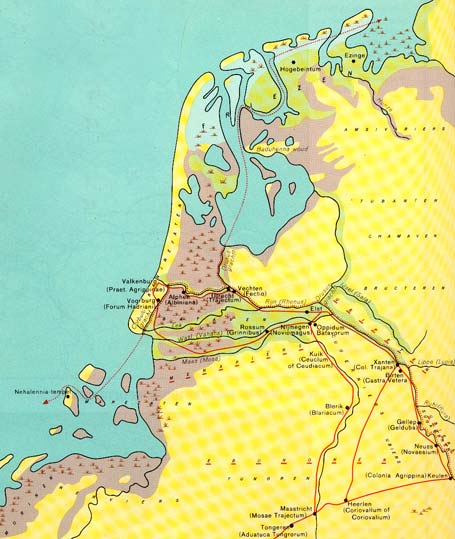
The Netherlands in the Iron Age
Source: H. Binnendijk (1968): Hettema's Grote Historische Schoolatlas (Zwolle):
Sources:
- Sonnema Beereburg advertising material
- Rik Eckhart
- http://www.orteliusmaps.com/images/5044.htm
- www.orteliusmaps.com/book/ort81.html
- "De Bataven, verhalen van een verdwenen volk" (book)
Editor/co-author: Hans.
Deze pagina is er ook in het Nederlands