
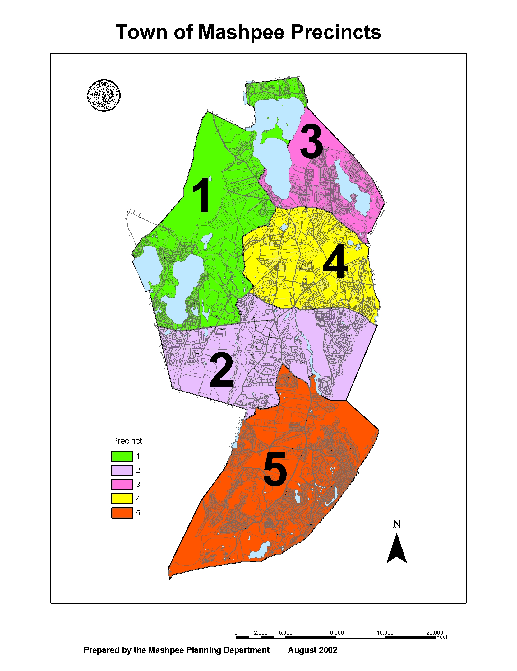
Voting Precincts in Mashpee
Precinct 1
Census 2000 – Precinct 1 (Population 2,690)
Beginning at the Mashpee/Falmouth town line at the northern side line of Nathan Ellis Highway (Route 151), thence easterly along said side line to the western shore of the Quashnet River, thence northerly along said western shore to the southern side line of Old Barnstable Road (Barnstable-Falmouth Road), thence easterly and northeasterly along said side line and continuing along the southern side line of Lowell Road to Great Hay Road, thence northerly along Great Hay Road and northeasterly along Simon Lowe Road to the western side line of Lovell’s Lane, thence northeasterly along said side line and across Main Street (Route 130) to the northern side line of Main Street, thence northwesterly along said north side line to the northern side line of Sturgis Lane, thence northeasterly along said side line and continuing on the same course to the western shore of Mashpee Pond thence southerly, easterly and northerly along the shore of Mashpee Pond to its northern intersection with the Mashpee/Sandwich town line, thence northerly, westerly, southerly, westerly and southwesterly along the Mashpee/Sandwich town line to its intersection with the Mashpee/Falmouth town line, thence southeasterly along said Mashpee/Falmouth town line to the point of beginning.
Precinct 2
Census 2000 – Precinct 2 (Population 2,580)
Beginning at the Mashpee/Falmouth town line at the northern side line of Nathan Ellis Highway (Route 151), thence easterly along said side line to the western shore of the Quashnet River, thence northerly to the southern side line of Old Barnstable Road (Barnstable-Falmouth Road), thence easterly along said side line and across Falmouth Road (Route 28) to its southern side line, thence easterly along the southern side line of Falmouth Road and the southern side line of Quinnaquisset Avenue to the intersection of the Mashpee/Barnstable town line and the shore of Shoestring Bay, thence southeasterly along the western shore of Shoestring Bay and westerly and northerly along the eastern shore of the Mashpee River to a point opposite Pem Lane, thence westerly by a straight line to the northern side line of Pem Lane and following said side line to the eastern side line of River Road, thence southerly and westerly along said side line and its projection to the western side line of Great Neck Road South, thence northerly along said side line to the eastern side line of Great Hay Road, thence southerly along said side line to Holland Mill Road, thence westerly and southwesterly along Holland Mill Road to the northern side line of Old Ockway Road, thence westerly along said side line to the Mashpee/Falmouth town line, thence northerly, westerly and northerly along said town line to the point of beginning.
Precinct 3
Census 2000 – Precinct 3 (Population 2,511)
Beginning at the Mashpee/Barnstable town line on the northern side line of Main Street (Route 130), thence northwesterly along said northern side line to the northern side line of Sturgis Lane, thence northeasterly along said side line and continuing on the same course to the western shore of Mashpee Pond, thence southerly, easterly and northerly along the shore of Mashpee Pond to its southern intersection with the Mashpee/Sandwich town line, thence easterly, northerly and easterly along said town line to its intersection with the Mashpee/Barnstable town line, thence southeasterly and southwesterly along said town line to the point of beginning.
Precinct 4
Census 2000 – Precinct 4 (Population 2,627)
Beginning at the Mashpee/Barnstable town line on the northern side line of Main Street (Route 130), thence northwesterly along said northern side line to a point opposite the western sideline of Lovell’s Lane, thence across Main Street to said side line and continuing along said side line to Simon Lowe Road, thence westerly along Simon Lowe Road and southerly along Great Hay Road to the southern side line of Lowell Road, thence southwesterly along said side line to the southern side line of Old Barnstable Road (Barnstable-Falmouth Road), thence easterly along said side line and across Falmouth Road (Route 28) to its southern side line, thence easterly along the southern side lines of Falmouth Road and Quinnaquisset Avenue to the intersection of the Mashpee/Barnstable town line and the shore of Shoestring Bay, thence along said town line northerly, westerly, northerly, and easterly to the point of beginning.
Precinct 5
Census 2000 – Precinct 5 (Population 2,538)
Beginning at the Mashpee/Falmouth town line at the northern side line of Old Ockway Road, thence southerly along said town line to Nantucket Sound, thence easterly and northeasterly along Nantucket Sound to the Mashpee/Barnstable town line, thence westerly, northwesterly and northeasterly along said town line to the intersection of said town line with the southern side line of Quinnaquisset Avenue and the shore of Shoestring Bay, thence southeasterly along the western shore of Shoestring Bay and westerly and northerly along the eastern shore of the Mashpee River to a point opposite Pem Lane, thence westerly by a straight line to the northern side line of Pem Lane and following said side line to the eastern side line of River Road, thence southerly and westerly along said side line and its projections to the western side line of Great Neck Road South, thence northwesterly along said side line to the eastern side line of Great Hay Road, thence southerly along said side line to Holland Mill Road, thence westerly and southwesterly along Holland Mill Road to the northern side line of Old Ockway Road, thence westerly along said side line to the point of beginning.
