

If you have made it to my home page, congratulations. You are either certifiably insane or a climber.There is probably no difference. The purpose of these pages is to let those that know me follow my journeys through the Cascades and it's fantastic mountain peaks. This is a work in progress and I hope to include itineraries, route notes and possibly a few pictures. There are no special skills here, no hard bodies or desperate moves, just a joyfulness in the creation around us.
Unless otherwise noted, routes are as listed in Beckey's "Cascade Alpine Guide" series with comments here being additions, errors or variations to his descriptions.
I begin with Mt Si(4176') on April 22, 2000. Nancy Maring. This is a main stay of the conditioning peaks. An all too urban atmosphere, it's proximity to the work-a-day world make it, none the less, a good early season outing with 4 miles of trail culminating at the "Haystack" which provides good views of the Snoqualmie Valley and early season rock climbing.
Spire Rock, April 30, 2000. Rock climbing instruction.
Wilkeson practice area, May 6, 2000. Mike Calder, Nancy Maring. A short section of sandstone cliffs northeast of Wilkeson (travel past the Wilkeson school and turn right at the second major uphill road. Park at the right branch of a wye in the road with a gate about 30yds away. Do not drive through the gate even if it is open -temporarily. Walk down the road about 1/4mi and take a trail to the left that begins at a culvert. There is a trail up from the gravel pit but has been largely overgrown and harder to spot), the area has lost some of it's appeal with most of the routes now being bolted or "hammered" in the crux areas. An interesting asset are the numerous mini finger holds caused by years of hunters and target shooters proving they CAN hit the broad side of a barn (or at least a cliff). Still, there is plenty of room to practice most rock technique except overhangs on fairly solid rock that comes into shape early in the season and dries rapidly after rains. Post outing: fully eight more routes have been bolted. At times the fixed pro hangs up the rope of climbers following traversing routes. Use caution here before making serious moves to avoid getting snagged mid move. The best (highest rated) routes are tward the east end of the cliff and , again, most are bolted.
Mt Garfield(5519')-South Route, May 13, 2000. Mike Calder Taking up the triangle formed by the Taylor River and the Middle Fork of the Snoqualmie River, Garfield has more of a "bad boy" reputation than it's 5519' would imply. Routes are all strenuous and those who fail to use caution are treated accordingly. Three fatalities and numerous injuries are recorded. Yet, most routes are not extremely technical. Water on route is in short supply late in season. Post outing: Ok, so we whimped out. We climbed as far as the "Y". A warm sunny day and substantial snow in the #1 & #2 gullies looked like an avalanche or soft snow slide just waiting to happen. Life is to short to take the risk. In this case, the next stop is straight down about 1000 feet of sheer rock in the Great Canyon. Do not laugh at the time estimates presented by Becky. They are very valid for climbers in reasonable shape and definitely not exaggerated. The route description is fair and in many areas there is a fair amount of surveyor's tape to guide you. Be aware that the "blazed" trail between the road and the first basin is poorly marked and often is a bit of a bushwack. Getting "on trail" as soon as possible is a key to reasonable times and enjoyable outing. "Veggie belays" are the order of the day. The climb schematic is by no means drawn to anything other than psychological scale with the portion from the slabs up greatly exaggerated. The route often follows a lower track than the ridge tops shown in the schematic and the glade saddle might probably be bypassed. The wooded ramp and key ledge are not technically intimidating but, don't be lulled into a false sense of security, rope up. A slip from this ledge sends one on a fast trip down the Great Canyon where hopes of survival are slim. Since the #1 & #2 gulleys face south, if they contain snow it is best to wait for cold weather or a melt out.
Noble Knob or Yakima(6231') & Naches Peaks May 28, 2000 weather dependent. Nathan Horne, Ashley Horne, LeAnne Horne, John Horne, Alan Chopay, Dick Chopay, David Celmer, Chelsea Celmer, Caitlin Celmer, . Noble Knob is a trail hike approx. 13mi from the Buck Creek parking area. Good views into Mt Rainier and the southern Cascades. Naches and Yakima Peaks are pleasant scrambles which begin directly from the parking area atop Chinook Pass. There are no technical difficulties however the ridge route to Naches is a bit airy in places. Post outing: Fog, rain and falling snow on the ascent and descent broke briefly while on the summit to allow views of the closely surrounding peaks. Snow depths are near 10' in the basin areas tapering to around 2' on the the higher slopes with slight cornicing on the north sides. The summit block is snow free. First time peak summits for Ashley(12), John and Alan. Bad weather precluded a Naches Peak try.
Florence Peak(5501') and Howard Peak(5720') June 4,2000 High points along the Alki Crest the peaks offer pleasant scrambling and a chance for multiple summits with minimal effort. Great views onto Mt Rainier and the Ptarmigan Ridge. Post outing: Warm and Sunny. For an interesting change from Becky, when taking the Boundary Trail from the Carbon River ranger station, leave the trail before crossing the first major creek. Turn left and ascend southeasterly to a ridge top and follow the ridge to Sweet Peak(minor rock scrambling to get on top) Sweet Peak offers a "sweet" view of the Carbon River and on into to Puget Sound basin. Continue on the ridge generally south/southeast to Florence Peak which is actually two peaks perhaps 50 yds apart. Continue again along the ridge south/southeast over or around several minor high spots to Howard Peak. The north/northeast side of the ridge is cliffs in many places. Northeast of Howard is a nearly equal height peak that overlooks Ranger Creek and Rust Ridge(an approach to Arthur Peak). Howard Peak has extremely gentle slopes, almost flat meadows on top, except for cliffs protecting either side of a northerly ridge leading to Rust Ridge. There is a steep but safe scramble route to Arthur however. Tolmie Peak lookout is clearly visible from Howard as well as the start of the Becky route from Tolmie down. Note that Becky's 4000 ft mark on the boundary trail can also be reached by taking the logging road up Tolmie Creek and then taking the jeep trail to the left which continues along the creek to just before a sizable swamp (avoid the swamp). After crossing the creek, at the end of the trail, take the fall line uphill to intersect the trail or continue to the ridge to intercept the route(about 400 ft to the trail or 1400 ft to the ridge crest). Return as per the approach but take care on route finding after leaving Sweet Peak. There are substantial rock outcroppings and numerous small ridges to place you just far enough from the trail to be nasty. The top down route of Becky is a bit whimpy but is best done if one has transportation on both ends beginning at Mowich Lake and takes the liesurely stroll to visit Tolmie Peak and then continue down the ridge. It is probably better to resist the urge to follow Tolmie Creek down to the Carbon River since this will place you in the middle of a nasty swamp.
Tyee Peak(6030'), Sluiskin Mountain-Chief(7015',+? June 21, 2000 Tyee is a just because high pointeast of the Yellowstone cliffs. Sluiskin Mountain is a ridge of rock outcroppings south east of Windy Gap. Both are accessed by the northern loop trail. Post outing: This turned out to be a very long trying event. The trip is 20+ miles rt and has 2 miles added each way due to the park service not replacing the Lower Carbon Bridge.(Note that the road to Ipsut Campground is again beginning to wash out.) Snow is in abundance from Yellowstone Cliffs Camp and with low clouds blowing through, whiteout conditions prevailed from time to time. Beckey's description on approach is right on. Do note, though, that if snow is on the ground, stay away from the scrub trees and head for a rock rubble at the base of the Squaw. The broad gulley between Squaw and Chief is un mistakable but is quite steep, at or near 45 degrees. Definitely best to do this with snow both for climbing and for the great fast descent glissade. The summit block of the Chief is a staired recess that almost begs for a "B" grade movie god to step out on the high platfom and begin dictating. The class 3 rock only goes that if you carry a spare "Depends" or are prepared for double cycling your next climbing clothes laundry. The number of rappel slings might attest that this is not solely my opinion. The class 3 stuff is probably the dangerous scree slope on the NW corner of the block. I would suggest that the fractured north wall on the inside of the "amplitheater" is the more sound rock with about 15' of easy class 4. Time precluded doing the squaw but, at this date a steep snow slope wirh a 30' rock scramble would appear to put you on top. You probably should allow an hour rt from the Chief. As Beckey noted, at least with snow, dropping over the back(south) side of the Squaw and heading for the Elysian Fields and contouring around Pacific Pont to meet the Wonderland trail might be a nice alternative. Tyee is a walkup.
Cupola Rock(6600') June 24, 2000. Nancy Maring. Probably the most sound piece of climbing rock around the Chinook Pass area, Cupola Rock is an outcropping of the ridge that leads through Sourdough Gap and is immediately east of the gap as approached by the Pacific Crest Trail at 2.5 miles from Chinook Pass parking area. From the west, the ascent gulley listed by Becky as class 3 is easy enough but, most people prefer a rope and indeed rappel slings attest to this. A single rope rappel from a sturdy tree at the top of the gulley will drop you into a 10' deep chimney that scrambles down to the beginning point. The other routes begin on the east side where the notch Becky mentions is located. Route 1 appears to have the first move missing, possibly broken away since the initial ascent. The south face and SE arete offer interesting 5.+ climbs but protection above the first pitch is slim. Post Outing: The area still has substantial snow in the bowl just before Sheep Lake. To there the trail is easy to follow. From there on, pick a point and follow your nose. Tendency is to go high. Judging from the number of slings on the route, Cupalo is getting a lot more traffic recently and again these slings say people aren't comfortable calling this a class 3 route. Lots of hand and foot holds and an endless variety of paths up the descent gulley. Watch for sharp edges that catch the rope. First real rock outing for Nancy. Great job! Close in. We'll visit again and try new routes. As the weather clears, the views south to the Goat Rocks, Adams, St Helens, etc. are glorious.
Mt Agnes(8115')-NE ridge(AsaPeak) route July 1-4, 2000. Mike Calder. A tough approach, by 1987, only fourteen parties had summited. Bridge washouts four years ago make crossing Agnes "Creek" difficult if this years river flows are equal to last year's. At 5.6 the climb is not as much technically demanding as strenuous. Although over 8100ft, Agnes is nearly forgotten but watches over the Agnes drainage like a towering ghost gaining 6000ft in 2mi. Postponed.
Crystal Peak(6615'), Crystal Lake July 9, 2000. A decidedly non-technical outing, both destinations are on trail all the way. The trailhead is located just before the Whire River entrance to Mt Rainier at what used to be the highway maintence shed (now removed and used for additional parking). The trail, which branches at about 1 mile, to the two destinations is forested for the first half and then opens up as you reach higher elevations. This area is within the park and park rules apply. A few yards shy of the summit, note the old footings of the now removed lookout. Post outing: Wild flowers are in full bloom and the animals are out enjoying the first real summer weather. The peak is close in and relatively easy so expect heavy hike traffic. Use the cars in the parking area to gage. This is one of the best views available of the White River as it exits the park all the way up through the moraines of the Emmons Glacier and up the climbing route to the summit of Rainier. Take the time to relax at pretty Crystal Lake. Continue past the lower lake to the clear waters of the upper lake cradled in a craggy cirque. The views a very alpine and the area has few rivals attainable with so little effort.
Lundin Peak(6057) West Ridge. July 16,2000. Mike Calder. A long scramble to the west ridge via Commonwealth Basin from the PCT trailhead at Snoqualmie Pass. Sound rock but only one short pitchof class 5+ one class 4 pitch or two pitches of class 4 depending on the route taken. Post outing: Having now taken bothe the Commonwealth Basin and Alpentol approaches, I would recommend the Alpentol approach after the snows are gone. The basin approach is a bushwack and talus scramble. A note from a party who climbed in May said the going was easier with snow and the 1500 glissade desent was fantastic.
Owyhigh Lake and Tamanos Mountain(6850') July 17,2000. Nancy Maring. A strictly tourist hike on good trails to the lake then scramble to the rounded peak of Tamanos. Post outing: Excellent weather. Only patches of snow remain on the sheltered slopes. Great views of the Cowlitz Chimneys, Govenor's Ridge and Double Peak plus, of course, Mt Rainier. About 9mi rt.
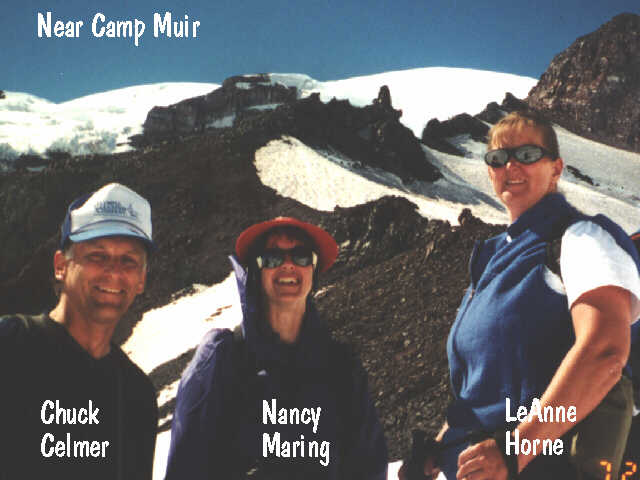
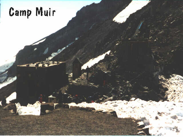
Camp Muir- Mount Rainier (c 10000') July 22,2000. Mike Calder, Nancy Maring, LeAnne Horne. This is the tourist version of climbing the mountain. Camp Muir is located on a ridge extension of Gibralter Rock which separates the Nisqually and Ingraham glaciers. Ascent is directly from paradise on trails to about Pebble Creek in mid summer and the balance on perpetual snow of the Muir snowfield the rest of the way. It is a continual upward pull taking 4-7 hours. There are no technical demands her but one should always exercise good judgement and caution when traveling this high on The Mountain. Although not a glacier, some smaller crevassing occurrs when there is extensive melting in some of the later parts of summer, depending on the year. BE CAREFUL OF THE WEATHER. Weather changes quickly and sometimes dramatically on the mountain and can become life threatening if not taken seriously. Post outing: Weather strikes again. The snow was in excellent condition. Steps were solid throught. The overcast of the Paradise parking lot opened up to nearly cloudless upperlevel skies in late afternoon. The areas below moon rocks deteriorated and by late afternoon were at near whiteout. Take extra equipment. We noticed several hikers who were dangerously ill-prepared, starting out for Muir too late in the evening with no backup plan and hiking/snowboarding alone. Great job Nancy and LeAnne on your first trip up the snow field.
Double Peak(6207') August 6,2000. Visible from just south of Cayuse Pass, Double peak poses a rocky outline amid the declining heights of the southerly high points tward SR12. and is much more rocky than Shriner to the SE. Good views of Cowlitz Chimneys, Tamanos and Govenors Ridge. Post outing: While one can certainly park and descend from the highway where Beckey notes, the Owyhigh Lakes Trail is so pleasant that the extra length is a good warm up or cool down for the climb. Park across the road from the trail marker. Note too that the reference to the map and the "k" on the topo depends on which scale map is used. At this time, the creek mentioned as the point to ascend is dry having gone underground a few yards uphill. But, this is the first drainage with a log crossing. Turn up immediately after crossing. There is considerable bushwacking through a variety of thorned brush near the base of the rocky outcropings. Keep just on the edge of the rock(circling north and west) and ascend to the edge of the basin, turn south and ascend a E/W ridge then contour NW around the east side of a hill marked 5795' and continue to contor to a gulley just below the SE face of the SW peak. Scramble the ridge and a short rock section to the top. Note that from a small flat half way up the rock, one can drop over to the north side and continue up or descend to a traverse to the NE peak. It also appears that it is possible to ascend the broad gulley between the two peaks to climb both although a short (10' to 15') class 4 rock may be encountered. The southwest face of the NE peak appears to be a moderate rock scramble.
Hessong Rock (6400') & Mt Pleasant(6453') August 13,2000. These are the two high points of the ridge north of Spray Park in the Mowich Lake area of Mt Rainier Park. More of a hike than a climb. Take the Spray Park Trail to a point midway between the two peaks. The secondary trail to the ridge saddle is visible from here. Post outing: The wild flowers of Spray park are in full bloom and worth the visit just for themselves. Plan extra time for this day outing and visit senic Spray Falls then after climbing Hessong then Pleasant, continue down the NE flanks of Pleasant tward Knapsack Pass and return to Mowich Lake or ascent to Fay Peak. Hessong Rock is ok by the Becky route but the NW Ridge can involve hard snow in late summer. My perferred route is to take the eastern most gulley on the south side - an easy scramble. Several other gullies and the west ridge offer 4th class routes on "iffy" rock. Take some time here to check out all the ledges and gulleys if you can talk the resident goat heard into sharing them with you. Both hessong and Pleasant offer great sites to route find your north Rainier climbs. Mt Pleasant itself offers no difficulties but is a relaxing place to stop for lunch.
Yakima Peak(see May 28, 2000) Nathan Horne Post outing: This is the first summit for Nathan(5 1/2yr). A great job for those short little legs. Wild flowers and huckleberries are at near prime. PLEASE...save SOME huckleberries for the bears (Nathan's request) so they don't get mad at us.
Castle Peak-Mowich(6116') Sept.-2-2000. Jake Parslow, Wayne Parslow. A mild scramble to a truncated summit north east of Mowich Lake and not viewable from there. Post outing: There is a option to take the Wonderland Trail from the lake to just before the Eunice Lake trail then just contour east to Castle. This is no great savings in time or energy and the objective peak is not in view during most of the traverse. Descent is definitely best done moving southwest through largely treeless slopes tward the north end of the lake thus avoiding the sidehill traverse back to the trail.(Foggy conditions put us on the peak viewable from Mowich lake. This is the southern extension of the ridge that is Castle Peak. See Sept 23 for notes on actual Castle summit.)
Mt Adams, south Spur(12,276'). Sept.-3/4-2000. This is the non-technical route taken by tourists and nonclimbers. It is highly populated and promoted by the forest service. New for 2000 is the Cascade Volcano Pass supposedly collected to make improvements to the roads, trails and safety of the climb route. Similar to Camp Muir hike but a bit more remote. Post outing: Even in bad weather (rain low and snow above 6000'), there are a lot of people on the trail. The route is well marked following an old mining road to the Crescent Glacier moraine and is generally dotted with numerous cairns from there to Lunchcounter. Water is sparce late in the season. If crowds are heavy or weather is bad, one might consider camping at the stone wind breaks just before setting on to the glacier. They are somewhat more protected from the wind and most climbers like to move to Lunch counter before stopping. The down side is that you need to climb the glacier in the morning before making the final, steeper 3000'. ******This is my page so I get to whine and here goes. The explosion of cheap, readily available gear has led to an explosion of "climbers" in the mountains with little or no training and who really should not be there. On this trip alone, I encountered three seperate groups who placed themselves in jeopardy or were injured (One person required an overnight stay and was helicoptered out the next morning just as the cloud cover came in again.) because of this. We need to realize that although the mountains can bring us experiences that lift the emotions magically, open the world of nature to our urban eyes and impart a near spiritual encounter to the soul, they are wholely indifferent to our presence. In an instant, your life can be changed forever...or ended. Be safe, be prepared and live to tell you grandchildren about your adventures. *********
First Mother,(6540'). Sept. 12, 2000. The highest point of Mother Mountain, First mother is near the far SW end of the ridge. From Knapsack Pass and Mist Park, the entire ridge is somewhat cliffy and there is considerable talus. Post trip: The entire route to First Mother is now a climber's trail to the summit. There are no difficulties or route finding. There are however several high points along the ridge before you get to the summit which might fool a climber. The true summit is fairly rounded to the north but breaks abruptly to a face on the south. Work around the intermediate high points on the north and ascend just north of the drop off. I continued NW attempting to traverse to Second Mother by dropping back north then along the ridge and down the talus slope on the south, through a short chimney,up to the ridge, back again to thenorth side and around several pinacles to the end of the easily scrambled route. This is at a place marked "M" on the topo and almost directly south of a large volcanic plug. At this point, First Mother Mountain is divided from Second Mother Mountain by a large saddle that appears to be guarded by cliffs on either side. It appears a rappel would be needed to continue. From the talus slope below First Mother, it appears that there might be a possibility of making a low traverse around the pinacles just mentioned and passed the saddle, picking a way through the cliffs on the south side of Second Mother.
Second Mother - North Ridge Route,(6389') and Castle Peak,(6116'). Sept, 23, 2000. This is the Ipsut Creek approach to the north side of Mother Mountain. Follow Beckey's info to start and wing it from there. The basins that are easily traversed when snow covered are probably covered with scrub brush in the fall. Post outing: Begin as per Beckey. Do not stay along the creek but on the ridge immediately west. When the ridge runs into a rock face, either ascend an open book to moderate open woods(if water isn't flowing) or move a bit right and circle around this obstacle to the same slopes. Moving up and to the left, one soon encounters a large (extremely brushy if not snow covered) basin on the east slopes of the north ridge. Ascend to the ridge (fairly steep but forested) and continue southerly to a meadow at around 4800'on the west ridge side. Ascend a gulley through a rockey face with a sharp pinaclethen back to the east side of the ridge. Continue along the ridge near the crest to a point which intersects Beckey's route. Continue up the north ridge direct to the summit (no register). To traverse to Castle Peak, descend from the summit of Second Mother via the approach to the first notch/gulley facing west. Descend this gulley and head tward a small lake to the NW. Keep above the lake and below the cliffs at the base of a shelf running north from Second Mother.(approx 5500') Contour around the northe side of the volcanic plug to the SE side of a small lake in the basin between Castle and Mother mountain. From the lake ascend easy heather and huckleberry slopes to the saddle between Castle and the high point visible from Mowich Lake. Pick up a climber's trail that leads to the north side of Castle Peak and crests the summit flat about midway. The summit is on the north end. To return, backtrack to the saddle, and contour on the north side of the high point seen from Mowich(needs a name) which will put you on the ridge directly above the lake. Descend fairly open, wooded slopes using game trails and a flatish drainage almost road sized to the Wonderland trail just north of the lake. Take the trail back to Ipsut Pass and from there down the trail to Ipsut campground. Note:any snow encountered on the north side of Mother mountain at this time is hard snow or ice.
Eagle Peak(5958') Oct 7, 2000. Nancy Maring. An easy 3.5 mi trail hike to Eagle Peak saddle then a short, nontechnical rock scramble to the summit.
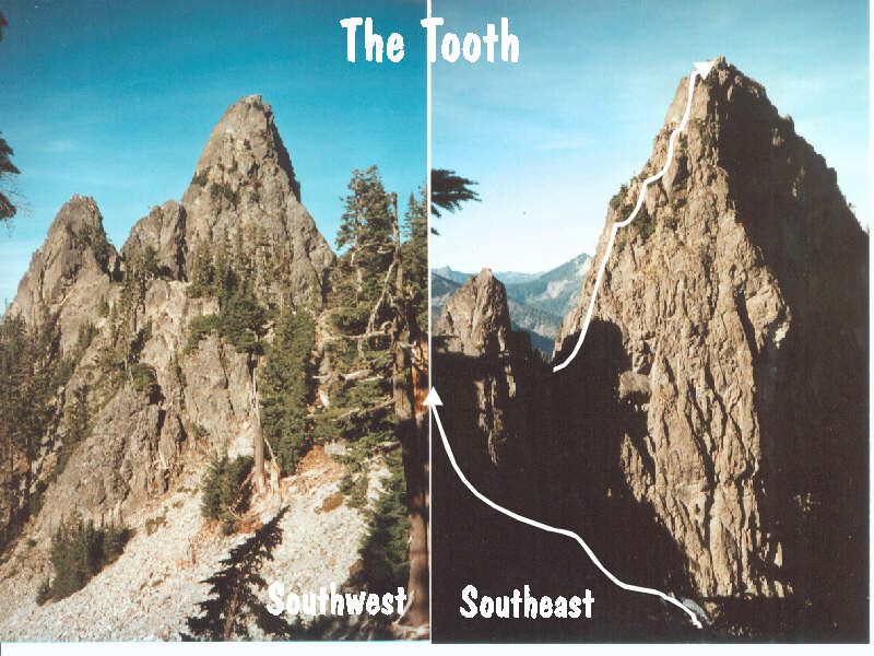
The Tooth (5604') South Face May 12, 2001 Nancy Maring, Mike Calder, Wayne Parslow. On the ridge line connecting Denny Mt on the south and Chair Peak on the north, the tooth is a pinacle that, in it's day was a substantial undertaking. With todays equipment and techniques the climb is a pleasant sport route which sees heavy trafic during the spring through fall seasons. Approach from Alpental/Source Lake then up the basin on the east side of the Tooth. Ascend a gulley on south of a small pinacle south of the Tooth proper then circle back around it's southwest side to Pineapple Pass and the start of the route. Straight forward routefinding and low class five climbing to the top. Take a map of the area to enjoy spotting yourself among the familiar peaks of the area. Post outing: There is still substantial snow in the east side basin and approach trail. All the talus is covered and glissading the descent is a joy. American Alpine Club was holding a climbing class here both Friday and Saturday of this week and also next. Expect LONG waits if you are not first on the rock. Hearing commands is extremely difficult here when the winds pick up. Suggest shorter pitches or run out the whole 60m of rope to avoid placing belay station directly under vertical wall below scrub trees.
Fay Peak (6492') May 20, 2001. The most visible point east of Mowich Lake is a short scramble from the basin just below Knapsack Pass. Take the trail (or follow the ridge line if snow covers the trail to the basin mentioned above. Ascend moderate snow slopes east of a prominent rock outcropping. Two horizontal rock bands divide the slope with the gradient steeper above the second. An ice axe is a requirement, crampons if the snow is hard. In late season the upper snow field remains while the lower melts to reveal the underlying talus. If snow covers the route, one may glissade virtually the ridgeline to the lower basin. Note that the upper rock band almost crosses the descent route and care should be given to avoid it in a glissade. Once on the east ridge, it is a very easy, short scramble to the ample summit. A pefect place for a summit nap and unsurpassed views of the NW ridges of Mt Rainier.
Old Desolate, (7130'). June 3, 2001. A large ridge of what would appear to be mounded talus, Old desolate has very little vegetation and is therefore very identifiable from Moraine Park. Keep slightly to the right of the creek descending from it at the lower level. Post Outing: Making this hike is definitely more enjoyable with the snow cover of late spring. Snow chutes lead virtually to the ridge crest. Take ski poles or ice axe to avoid the holes and slanted rock just under the snow surface. Although not really talus, the rocky surface is highly fractured completely to the surface. The more easterly side is more sheer than the Moraine Park approach side. Note that the highest point shown on the far easterly end of the ridge is not the summit but the more centrally seated rise. Snow is on the trail to Moraine Park and is drifted to 5-7' in the gulleys. Lower trails should be snow free soon.
Mt Garfield(5519') June 14,2001 See may 13,2000. Post Trip: Rain and dense fog caused a turn around of this solo attempt just before the key ledge.
Ipsut conditioner. June 24,2001 Hike trails from Ipsut Campground to Ipsut Pass and ?. Post trip: After the pass I hiked to Mowich Lake on mostly clear trails but there are still several feet of snow on the road into the lake. Met a Ranger who said the road had 4' of snow in places but they hoped to open the road bu July 4th. Another hiker who had followed me up expressed an interest in visiting Spray Park. Ranger suggested the trail was "a bit sketchy" from the park to the pass to Seattle Park. Turns out the trail is burried under several feet of snow from Spray park on and an unusually prominent summer storm with snow and white out conditions turned us back at the pass from possibly making the route down Cataract Valley. A team of two had set up camp at Spray Park during the white out enroute to the Ptarmigan Ridge but, followed us up mas far as the pass.
Naches Peak(6457'), June 30, 2001. Nancy Maring. Easy hike/scramble from the Chinook Pass parking lot via the North ridge. No difficulties except a 8' step near the summit. Large flat summit area perfect for views and summit naps. Post Trip: Descent down to the slopes below the summit rock then around the south shoulder and back via the south ridge tward PCT taking a snow gulley to intersect the trail sooner. Note, there are several rock gulleys on the east that could make interesting class 3 routes up the final rock. Also, when descending from the south shoulder, beware of cliffs. The south east tending ridge has a trail on it but ther is one direct route through the cliffs at a fairly steep class 3 gulley. From the top, the gulley separates around a large stone with the left side being easiest. Keep an eye out for the resident goats on the east flanks.
Mt Rainier(14,411'), July 8-10,2001 Jeanette Higgins, Lisa Corkum. Emmons Glacier Route...Glacier Basin, Emmons Flats, summit. Three days with ascent from Emmons Flats and return to the car in one day. This is the least technical route on the mountain however, this year, with low snow conditions, there is the probability of more crevassing. Post Trip: Cimb leader got sick (me) and we were forced to return before reaching Emmons Flats. Note that the Interglacier is extremely crevassed compared to other years and snow bridges are collapsing causing the route to change continually. Many slips into crevasses have been reported this weekend and at least one extraction was required.
Garfield July 28, 2001. Another recon in good weather this time. The route is viewable and fairly obvious from just before the "wooded ramp" but, discretion says that soloing this is probably not a good idea. There are several spots that, while not extremely technical, deserve the respect of a rope for exposure reasons. It is a long bounce into the Great Canyon. Viewing from this point and below though, there does appear to be a posible Great Canyon route for a couple of hardy souls.
Natural Bridge/Windy Gap August 12,2001. A trail hike from Ipsut Creek across the Carbon River (lower foot bridge has been replaced this year but heavy heat induced melting threaten to wash it out again). The route is far easier to find with the snow off the trail and the steep forested trail, so bleak in bad weather, is a pleasant shaded stroll in the hot summer. Wild flowers abound on the slopes below the Yelolowstone Cliffs and around Windy Gap. The natural Bridge is a short otherwise unworthwhile diversion from the normal trail on a short spur that goes nowhere. The bridge itself is situated below any real advantageous view point and is somewhat disappointing as it straddles a somewhat wooded ravine. Do, however take the time to scramble down the few feet from the view point and carefully walk out across the bridge. It an excellent place to enjoy your lunch while viewing the lakes below and the northeast corner of the park. Use care. A fall from the bridge would be disasterous.
Exit 38 - "Club Paradiso"- Lush. August 19,2001. Nancy Maring A first venture into the highly popular sport rock climbing area located between North Bend and Snoqualmie Pass. There is an excellent web link at Deception Crags.com with pictures, route descriptions and ratings. A nice diversion if time or orhter circumstances make alpine climbs out of reach. Most climbs are mid 5's and are not top roped unless first lead. A fair number of climbs are located right along the old railroad grade/bike trail (as are the crowds and foot/bicycle traffic) while some of the more challenging routes are found at outcroppings along the Mt Washington Trail.
Liberty Bell - Becky route (7720') August 26,2001. Mike Calder. A familar view on postcards of the North Cascades National Park, Liberty Bell is as impressive in person as it is in the photographs and it's proximity to the road makes it an irresistible draw to rock climbers. The Becky route (first ascent)is relatively moderate and is one of the shortest routes to the summit. Views are somewhat blocked to the south by the higher, nearby South Early Winter Spire but breath taking none the less. Cameras are definitely to be on your list. The "wine spires" to the east, Dome and Glacier to the south and the Pickets to the northwest are all very evident. Post outing: The route is extremely obvious but if there is a question, look for pitons at the crux moves. The rappel route is notorious for hanging up the rope on double rope rappels. Use a single rope and use an intermediate ledge as the second rappel anchor. A resident heard of goats is quite climber friendly and not a bit afraid of looking through you pack belongings if you don't take precautions.
The Tooth (5604') South Face Sept 2, 2001 (see May 12, 2001) Nancy Maring. With last winter's snows melted away, the approach from the end of the trail near Source Lake entails dancing with the talus in the gulleys feeding the lake and in the upper Great Scott Bowl. Post trip: Because of the frequent climber traffic, there are numerous approach "routes" through the talus and forested ridge beyond trails end. In the upper bowl, there is a hikers trail on the extreme left of the talus to about 2/3 of the way up. Water at this time of year needs to be carried. On the actual climb, each of the four pitches are almost exactly 30 meters and therefore the route could be done in two pitches with a 60M rope but, communications are nearly impossible without radios and for that reason the four pitches would be recommended. From the summit, note not only the local Snoqualmie Pass area but great views into the extreme reaches of the Middle fork Snoqualmie, Mt Stuart, Glacier and an "ariel" view of Mt Rainier to the south. This is the first alpine lead for Nancy. Great job!.
Camp Muir (10,000') Sept 11,2001. Due to low snow fall during the last winter and warm dry weather this summer, the upper Muir snowfield is reported to be crevassed with appropriate route changes to accomodate. Post outing: Despite the east coast terrorist activities, the weather was perfect and the usual summer tourists were gone. As expected, the route has shifted to the east side of the snow field to avoid major crevassing further to the west side. Still, at this point, 24 fissures were encountered ranging from 1/2" to several feet wide actually crossing the track. All are easily negotiated and cause no problem. There are several water ice patches enroute. There is insufficient snow to become slushy in the afternoons but the ice melts into puddles and rivulets on top of the ice making parts of the track a bit soggy. RMI was requestingtheir clients to use crampons and rope up from the moon rocks level on. An interesting side line to the low snow and high melt rates is that in several places, the underlying silt that has been dammed up under the snow and ice has melted free and burst out from under the ice layer to form small (20' to 50') mud flows along the melt water drainages. In places this is on or crosses the track. The Nisqually Glacier, especially the lower sections, is especially melted back and broken up. Ice along the moraine is black with debris and eroded into miniature hodoos.
Exit 38 September 15, 2001. Nancy Maring. Post outing. It is hard to beat this area for the mix of climbs and ease of approach AND ..get this...lots of parking. Visiting the deceptioncrags.com site or having a guide book will make chosing your routes easier. Take along your best belay buddie and stretch your limits. It will definitely show up in your alpine climbs. Be sure to leave early to avoid the bulk of the crowds and be willing to spend a little time after and between climbs to see some really good climbers. It can be humbling.
Cupola Rock (6600') September 22,2001 Wayne Parslow, Gary Stone. See June 24, 2000. Post outing: Nothing new here. A pleasant revisit of a familar summit via the easier route. As always, great views and good weather doesn't hurt. First time up for Gary and Wayne. Note that Wayne and Mike Calder (previous climb) feel that the route is definitely class 5. There is approximately 30 meters of roped travel and a single rope will suffice for the rappel (either a 50 or 60 meter).
South Early Winter Spire(7807')October 14,2001. Nancy Maring. An easy rock climb in one of the best rock climbing areas of the state with the advantage of an extremely short approach. The most difficult moves are on the start and at an exposed traverse on the third pitch. There are easier moves around those places if you so desire...just look around the corner. Be awaqre of loose rock while crossing the gulley near the summit. Post outing: The first snow of the season blanketed the area and a layer of fog hovered around the peaks so, for safety, we opted not to rock climb or do the alternate of a Whistler Mtn scramble. We did make the hike to Blue Lake high in the bowl above the trails to Liberty Bell and the Spires. Beautiful alpine setting and a suprising amount of foot traffic for that itme of year.
Nobel Knob. November 24, 2001 Nancy Maring Eric, Renz. My standard conditioning trail going to near the peak with a short scramble to the top. Good views if weather permits. Post outing: Nice cool crisp weather but clouds obscuring the distant views. Approximately 24" of new snow at the summit and a chance to try out snow shoes. This is the first time out with us for Eric. The trail is in excellent condition with only two trees across the trail and little debris.
Camp Muir (10.000'), December 29-30, 2001. Nothing new here except a chance to see the drastic change in snow conditions from the dry summer browns to early winter white. The snow enroute is perfect and, on this weekend at least, the weather was equal to any August/September day. The full moon would have made a summit attempt very desirable. There are lots of people at the lower elevations but few venture above Peble Creek. RMI was teaching a climbing seminar with two small groups so the solo experience was far from solitary.
Mowich Lake. January 5, 2002. Gordie McGougan. Again nothing new. The approach road is snowed in about 1/4 mile before the Paul Peak Trailhead with spots between there and the Evans Creek ORV park that have enough snow to make it questionable for low clearance passenger cars. The lake is completely frozen and has seen only moderate foot traffic. There are three to four feet of snow depending on drifting conditions. Grindstone trail is well flagged and is the desired route except for some cc skiers.
Pitcher Peak(5933') April 6,2002. For some reason, this peak seems always to be shrouded in fog at this time of year. Snow will stop vehicular traffic three miles from the river. Note that the new bridge is completed and open for travel. All washouts have been repaired and the road is passable to McGilvery Creek when the snow melts. Road side alders have been trimmed back on the main road but not yet on the Summit Lake section. Snow is very wet and in the McGilvery homestead area are up to five ft deep. The approach gulley is relatively stable but may be prone to avalanching. The wooded ridge to the left is safe but has sections of measured 45 degree snow (generally 40 degree). Be sure to take a moment to get your bearings while in McGilvery basin incase fog blows in. Not much to see today with a biting snow and wind on the summit.
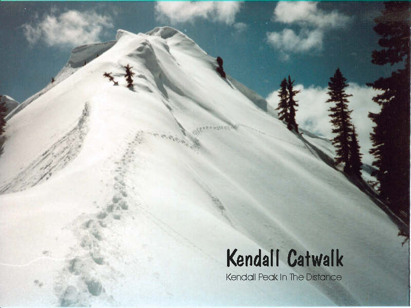
Kendall Catwalk PCT Snoqualmie Pass. April 28, 2002. Spring is here but there is still plenty of snow in the mountains. The Commonwealth parking lot is unplowed and soft snow makes snowshoes desirable almost immediately. The ski slopes have no skiers and there are few, as yet, hiker/snowshowers for the spring. Most tracks take off willy nilly from the parking lot and you need to take your own or be prepared to deviate from the normal PCT. The exposed slopes under Kendall Peak have much snow and several layers of crust which is quite stable for individuals or small groups but larger groups might do well to stay high to avoid avalanche danger. The catwalk itself is under much corniced snow. On this date, the warm sun and clear skies showed off all the neighboring peaks in high contrast to the blue skies. The original intent was to take the alternative route mentioned by Beckey from just beyond the catwalk then along the ridge to Red Mountain. It should be noted that, at least from a distance, there appears to be an erosion in the ridge that leaves a sheer 40'+ wall along the ridge and following down the south side into an active avalanche chute. This should be checked out in summer before trying a winter ascent of Red by this route. The solitude of the area now is sharp contrast to the summer hordes that will be there in a month or two.
Old Baldy Mountain (5795') May 11, 2002. A somewhat mellow hill just NE of the Carbon River entrance to the MRP. Access is via the newly completed bridge (left) over the Carbon River just before the park entrance. Turn right after crossing the bridge and follow the road to the second righthand fork(turns down hill and has a gate. The approach trail is an old logging spur across the road and is a passable jeep road a good portion of the way. Post trip: Take the jeep trak to just before the highest point the map shows crossing Kennedy Creek, a flats of sorts, (following the road to the end will skirt the next ridge east and end up at Suprise Lake. The road may have been extended here after Beckey's early editions.). Turn left up an old cat track(road?) and follow it till you pass a small pond and are looking at the ridge below the false summit. After attaining the ridge, stay slightly left of the crest until a single rotten rock block with a small tree growing out of it is seen. This avoids the unpleasantness of falling down the cliffs if there is snow. Pass the rock on the uphill side and move over to the right side of the crest for easy going and a straight shot to the false summit. The saddle between the false and true summits is long and gentle climbing more abruptly as one approaches the main summit. Winds whip snow over and around this ridge making for a somewhat exposed but not dangerous traverse. The crest is knife edged when covered with snow but, the drop off is fairly gently to the north and not bad to the south. The summit boasts views up and down the Carbon River and magnificent views of Rainier from Camp Schurman to the Puyallup Cleaver. Fun and relatively easy.
Carbon RIver/ Mowich area May 19,2002. Nancy Maring Just a fun conditioning hike and a chance to get up close and personal with the Carbon Glacier. We talked with one of the climbers who descended the glacier after an aborted attempt on Liberty Ridge due to high winds and blowing snow. It was this person's 4th unsucessful attempt. His good judgement showed up the following week when three persons died after summiting that route and being caught in bad weather.
Mt Rainier Circle (7200' to 10,500') June 8-11,2002. This is an attempt to recreate the trip discussed by Dee Molenar in "Challenge of Rainier". We will be changing a bit, beginning at Paradise rather than White River camp ground and we will try to cross the Emmons Glacier from Dissappointment Cleaver to Camp Schurman. A trip to Old Baldy on May 11 showed the west and north sections of the rout to be in excellent shape. Post trip?: cancelled due to lack of interest.
Red Mountain (5890') June 9,2002. Red Mountain is a smallish peak heading the Commonwealth Basin directly north of Snoqualmie Pass. It's red rock is in sharp contrast to the silver grey granite of surrounding peaks and it's sheer north face makes it identifiable from great distances. Post outing: Approaching from Commonwealth basin, currently snow is encountered at the main road (parking lots are not cleared) and is part of travel to the summit except for a couple of rock bands exposed on the ridge. The rock is somewhat loose and crumbly so care should be taken while directly on the somewhat exposed ridge. While snow still covers the ground, there is a slightly more steep but all snow route to the left of the ridge. No difficulties and the summit, although exposed, is fairly large and has large rocks for the typical "summit lounge". Great views of Thomson, Lehma, Lundin and Snoqualmie. A relatively easy three hours from the car to the summit.

Gunn Peak (6240'). June 15,2002 A highly eroded rock ridge located north of Barclay Creek and the town of Baring on Hwy 2 Stevens Pass. There is substantial local relief and the climb is continually up. Post climb: I find the description posted in B eckey's to be confusing as did another group of climbers encountered at the trailhead. This is partly due to references to clearcuts 25 to 30 years past. Here's chucks route description: Take the Barclay Creek road (directly north of the Baring grocery store)ignoring all branches, for around 3.6 miles. At this point one can see Barclay Creek just below the road. Just ahead of this siting is a 90 degree spur that heads to the creek. It is obviously short and one is better off parking on the main road. Just upstream from where the spur USED to cross the creek, there is a "U" shaped log jam crossing the creek. During times of high runoff, it would not be advisable to ford the creek. After crossing the creek, head due north or back along the creek across from the spur (brushy) and pick up the old spur or the old trail running parallel to the creek. Take the old trail left (west) until you meet with a northward skid road marked with a blazed alder. Take this skid road through what "USED" to be the clearcut and find a climbers trail that begins at it's end.(This is crutial to having a trail to follow rather than cross country around the waterfall.) The climbers trail can be takento the base of the rock buttress mentioned by Beckey or may be taken a bit higher. Drop into the gulley along the buttress and take it up to the notch left of a small gendarme. (This gulley is supposed to be class two but you might be more comfortable calling it class three. Drop down from the notch and cross a SMALL stream bed and up the other side on obvious ledges. Either continue up the ledges to gain the top of a small ridge that fronts the next MAJOR drainage or continue around and down into the drainage. In either case, looking uphill at a saddle, with a rocky peak to the right, the saddle is the ridge crest Beckey mentions. The rocky peak is PT 5760. Attain the crest and turn left and traverse the basin under Gunn Lake saddle to a scree gulley that eventuall turns right. (before making the traverse, note the notch in the Gunn skyline. This is the point where you need to be when you turn left to the summit.) On this trip I encounter the previous mentioned party a number of times an would wait to put some spacing between us. Eventually, at the ridge to 5760, I opted out and just scrambled 5760. A nice little hill with a craggy feel. There is a pushy little face on the west but circling to the east side, there is a easy class 3 to the top. (Note that the whole south face below the summit block is strewn with aluminum from some long forgotten air mishap. Judging from the debris and the size of the peak at that point, another 100' left or right and the pilot would have gotten away unscathed.) Views from here to Merchant, Gunn and Baring are fantastic. For Gunn 6 hrs is moving fairly fast, add an extra hour or two.
Unicorn (6917'). June 23, 2002. Nancy Maring. The highest of the Tatoosh Range, Unicorn is easily visible from the Paradise area of Mt Rainier Park as well as many places on the Stevens Canyon Road. As it's name implies there is a solitary rock outcrop on the top looking vaguely like a unicorn horn as it slopes up from the southern ridge. Approach is via the Bench/Snow Lake trail scrambling up the obvious feed gulley slightly west then south to the ridge crest below the summit block. In summer, after snows melt, there is a climbers trail that runs to the left side of the gulley/basin. The final rock can be scrambled on the south east or a short rock pitch on the south which is also the descent rappel route. Post outing: There is still snow covering the approach from the cars up. It is in good shape but melting rapidly before Bench Lake. Unicorn Creek is completely covered with snow and offers a good glissade both from the saddle and down the chute to Snow Lake. The summit block was shrouded in fog and we turned around at it's base.(Sun reappeared as we hit the cars and the view to Unicorn was, again, unobstructed.)
Echo Rock(7862') July 7,2002. Visible from Spray Park looking tward Mt Rainier, Echo Rock appears craggy and it's bright red color is obvious. Approach from the Spray Park trail at the pass to Seattle Park. Post outing: Mowich Lake road is still closed for snow but is mostly melted out. Trails are snow free till uphill of Eagles Roost and are largely snow covered from the lower parts pf Spray Park on but are easily followed if one has been in the area before. Newcomers could find themselves wandering a bit. Despite record late snows, the approach to Echo is quite bare. The snow on the Russel Glacier is in good shape and reasonable hiking shoes are sufficient. The easy scramble route starts by reaching the rocks via a scree slope on the south and picking your way up the easyrock and "trail" to the summit (10-15 min from the base). The technical level is 0 but the loose and crumbling rock requires you to pay attention. (Note that the obvious west gulley is both harder to get to due to the large moat and very loose. Probably not extremely safe.)
Wenatchee River. July 13, 2002. LeAnne Horne, John Horne, Ashley Horne, Nancy Maring. Ok, so Remlec's world isn't ALL rock, ice and snow. We are using the guide service, River Riders, to raft the Wenatchee River between Leavenworth and Cashmir, WA. They will supply all required items and lunch. Prices seem very reasonable compared to some outfitters. This service is also one of the few that welcomes the youthful (Nathan is 8 ... almost). Post outing: Wet and Wild. The day started out extremely hot, very muggy and uncomfortable. We arrived at out departure point and found everything very well organized with wet suits and booties being distributed and lunch being served. (BBQ ribs, hamburgers, (veggie burgers for vegetarians by prior request), lots of fruit, salads and cool drink or water. After being assigned a guide we carried our raft to the water and got introductions and the beginnings of some instruction. Once we got out on the water, we got more instruction and a chance to practice on the more mild waters upstream of Leavenworth. Clouds were gathering quickly and rain began to fall just as we were getting fully underway. As an added bonus, bolt lightning and booming thunder rang from the hills along with the rains that drastically cooled of the temperature. Virtually out of nowhere comes the first rapids ... a hole really ... that I'm sure woke everyone up and got them wondering if they remembered all the "man overboard" scenerios the guide had given us. Nathan was not amused. We continued down river, a little rapids, a little calm till we hit the Peshastin Flats. This is about half way through the trip and a very gentle section. Time to play. Water fights between boats(by mutual consent only). The "rodeo ride" where a rafter holds a rope, stands on the tube and lets the rafters spin the boat around and try to dislodge him. Several of the "cowboys" got "throwed". Past Peshastin, there is a portage around a small dam and a series of class three rapids. We were told that the river was running pretty fast and it would be one of the better rides. It was definitely wet. Each of the rapids is named, "meat grinder", "suffocator", etc but the only on we will really remember is "SnapDragon" a class three where our intrepid Ashley sat on the front of the raft like a hood ornament, feet out and seat in. Up close and personal with the river. There were several flips of rafts and the accompanying inflatable kayaks but no problems. We took out at the landing at Cashmir City Park and loaded busses for the ride back to Leavenworth. By this time Nathan had begun to enjoy himself and dubbed the trip awesome. I recommend the trip and the service to anyone remotely interested. They also raft other rivers ... easier and more challenging. There are several campgrounds (fee charged) in the Icicle Creek valley or hotels and inns in town (pricey but THEY have showers.)
Bruces Thumb & Roto-Wall. July 14, 2002. Nathan Horne, Nancy Maring. Right along the Icicle Creek Road, there is zero walking to solid climbing opportunities. There is NOTHING remote about these areas and you are just as likely to find families with dogs and babies and chairs as seasoned climbers but for what the area is, you can get lots of practice on mid fifth class rock. Post outing: Nathan spent several hours at Bruces Thumb working on friction climbs and lowerin off the rock. Nancy spent her time giving him pointers and a different perspective on climbing. Nancy and I moved on to Roto-Wall for the afternoon where we worked on setting pro on several of the mid 5th class routes. Buggs were gone but the rocks in the afternoon sun were scorchers. Climbing from daybreak till noon is best right now. Eat breakfast after it gets hot.
Mt Washington - east ridge (6255'). July 27,2002. Mike Calder. Mt Washngton sits at the north end of Lake Cushman on the Olympic Penninsula. It is part of the Washington/Pershing massif. The route is not extremely technical at class4 but is long considering that extensive logging in the area has built roads quite high in the area. The east ridge is attained by following the Jefferson Pass trail to a small saddle then taking a climbers trail west to and along the ridge, deviating from its top to get around local rock outcroppings. The route deviates from the ridge greatly in the Big Creek cirque which is entered to avoid a large headwall and is reattained via a gulley with a large chalkstone (30' viewable from the road). A more exact east ridge route is to take the first gulley to a ridge saddle then climb a small summit (perhaps class4) directly above the chalkstone gulley and meet the normal route there. Expect a rappel in either case. Post climb: a newer section of trail has been put in place leaving Jefferson Pass and before reaching the ridge. This avoids an unpleasant ascent and descent of a loose gulley that continually washes out. The ridge trail is loosely defined and marginally flagged. We chose the right side of the large chock stone and the upper chock stone variations to attain the ridge from Big Creek Basin. The move up and over the chock stone is the only place that a belay or pro is required on the route. Turning left along the ridge, the tendency is to follow to the high point (the nose) but the route is actually three terraces down where a small ledge leads to the 10' rappel or down climb. From there the route looks to follow the ridge and then take a severe vertical pitch or descend rock slabs and ascend an extremely steep snow chute. Without giving everything away, take the ridge route and trust that everthing unfolds nicely. Winds and clouds came in as we approached the summit but, opened enough to show what great views of the interior of the range has. One could descend the route, but that would require a number of rappels and down climbing. A better alternative is to take the ridge further on down and descend to the first gulley as described earlier. This can be done less rope in it's entirety. I suspect that most people choose to descend the basic climbing route (guide book #1) which is all trail and nontechnical. This may be a requirement for people without the skills or equipment to do the previous routes but, it is extremely unsavory. While initially a ridge trail, dropping down the gulleys and side hills, it seems like an unending series if scree gulleys and one often finds hinmself glissading the stuff unwillingly. This route also lacks the benefit of the hiking trail (as opposed to a climber's trail) on the initial mile ore so to Jefferson Pass. You will meet the road just past the junction of the Mt Ellinor road and will need to hike back to the car.
Exit 38 (Snoqualmie Pass Highway) August 4, 2002. Mike Calder, Nancy Maring. Rock climbing practice.
Puget Sound Upclose August 9-11. Nancy Maring, Sandy Maring, North Cascades Institute, instructors and students with Vashon Island Kayaking. What's happening here with this is water stuff? In a diversion, we took an informal tour of the marine biology from Vashon to Blakely Rock. Starting off Friday we a stayed at a youth hostal. Saturday we started by exploring the Fern Cove estuary along the shoreline then took to kayaks to Blake island where we had lunch on the south beach. On departure, yours truely practiced wet exits inadvertantly. That task achieved, we sailed on to the northwest tip of Blake Island to camp for the night. In the morning we paddled toward Bainbridge Island and around Restoration Point and on to Blakely Rock which sits off Bainbridge and is mostly covered at high tide. The currator of the Seattle aquarium was our guide and instructor here for a tour through tidal pools and the marine life within them.
Washington Pass (Liberty Bell, South Early Winter Spire, ?) August 17/18, 2002. Nancy Maring, Mike Calder, Ann Ziegler, Morgan, Lyman, Anastacia H. A return for some of us and a new set of opportunities for others. This is a chance to encounter some of the best rock in the North Cascades with little effort. Approaches are short and routes are mid fifth class up. We are looking for sure to do Liberty Bell via the Beckey route and South Early Winter Spires via the South Arete. Post outing: We left the Blue Lake parking lot around 11:00am. This was almost too late for a group this size. I would suggest that for multiple rope groups, either arrive VERY early or the night before. A 6:00 - 7:00 am start makes for a leisurely day. Even in the moderate warmth of this weekend, the aproach gulley extracted a suprising amount of energy. The upper sections of the col just below the notch were a concern to a few. About 75 yds from the start of the route Nancy needed to turn back due to a recurring knee injury. At this point also, we were hit by nasty cool winds and some precipitation. A lesser equipted rope team turned back. Things can get ugly reral fast a mile or more from the road and over 6500'. We reassigned the ropes to reflect our injured climber and proceeded. Communications were lost at the second pitch as winds kept commands from being heard for nearly a half hour. We had a radio set but, one unit went down with the injured climber. (I should have made sure that teams had better rope signals and that the belayers kept enough slack to feel those signals.) The next pitch and scramble to the top was uneventful. After a bit on top we descended the rappel route to the notch at dusk with me last in near darkness. We were able to pick our way down the more sticky portions of the upper col and past that, the moon was out bright enough to allow us to trace the climbers trail to nearly the main trail without lights. After that it as just a short hike back to the cars and the dinner Nancy was working on. The next morning at breakfast, we realized that on whole, the group had expended more energy than expected and opted not to climb Early Winter Spire in favor of going to Leavenworth and spending the afternoon on the roadside rock. A generally satisfying outing and a good climbing effort by people who, except for Mike and myself, are not trad climbers or trad rope leaders.
Sheep Lake, Cupola Rock. Dick Chopay, Nathan Horne. August 30-31, 2002. Mostly an overnight outing with an easy rock trip to Cupola Rock as a bonus. Parking at Chinook is always crowded but more so on this Labor Day weekend. The mostly flat trail was unexpectedly uncrowded for the hike in and there were only three other campers around the lake. Late afternoon the skies were clear but the wind blew fairly hard. During the night the continued winds snapped an aluminum tent pole and tore out a tie down loop from the tent. In the morning things were calm again. Due to the proximity of the cars and the mild terrain, I slipped back to the car to bring up breakfast supplies for french toast. Dick stayed around the camp area while Nathan and I went for Cupola Rock. This was Nathan's first alpine rock climb and we chose an easy route to the top. Nathan did an excellent job with his short 8yr old body. The peak still sees only a few climbers a year or at least climbers who sign in. The weekend hikers began to come in and many were at Sourdough Gap, often watching the "odd people" climbing Cupola. A full length rappel brings us down into the chimney near the beginning point. For some reason, most climbers appear (from the slings in place) to choose to down climb half the descent route then rappel across the chimney which is a non technical walk up. Once back to the trail, it's a liesurely hike back to the lake, then the cars. On the way back to the cars, the expected throng of holiday hikers and campers began to drift in as well as a lot of day hikers just visiting the park but closer to the parking lot. Get out early if you are going to camp at this lake during a holiday. It is too close and easy to have any solitude at such times.
Tolmie Peak(5939') September 21,2002. Nancy Maring. A pleasant hike from Mowich Lake by trail to Tolmie Lookout. A Short scramble leads to the true summit perhaps 500' further along the ridge. No problems and there are fewer hikers. Views on the North faces of Rainier are the best available with so little effort. A true Kodak moment. Post trip: HUCKLEBERRIES! Take take time to pick a few huckleberries, sit by pretty Eunice Lake and watch the raptors glide on the air currents. This is definitely a "family trip" not a hardcore outing.
Mt Garfield -Main Peak (5519') September 28,2002. After past visits, I said I wouldn't solo this peak but, here I am again. Other climbing partners have all bailed so, it's now or never. The class 4 rating is well within my range and I suspect there are just little mind games going on knowing of past problems. Post outing: The trail is reasonably well flagged despite rumors to the contrary. Still, it is easy to get off route if attention is not paid. I seemed to be moving incredibly slowly but arrived at the "forested ramp" an hour sooner than expected and kept that through to the "Y". The "key ledge is not as bad as might be expected but the compacted tree needles give little footing an a slip here would certainly be fatal. Exercise caution and good technique. It is amazing that the original party even saw this as a/the route option. Crossing from the 1 to the 2 gulley covers the same exposure and bad footing as the key ledge but has more trees. No problems getting into gully 2 or proceeding up initially. As you get higher the gulley narrows and the rock from Leaning Spire overhangs the rock from Main Peak. At this point I found myself working up and to the right of the gulley as is the route Beckey gives. Doing this bypasses the steps and chimneys further up the gulley. Perhaps similar in difficulty except where the mentioned route is reincountered. There is a bit of a vertical bushwack as you climb over and around scrub trees and rock to the left and into the gulley leading from the col to the summit. This gulley is gained about half way to the summit where a goat/hiker path takes you to the top. Arrival here too about an hour ahead of expectations. Great views to the north and east as well as a view of the Snoqualmie peaks from the north. Be sure to check out the summit register. There are a couple of heavy weight names in NW climbing there. The register was placed in 1987. Although I noticed a few rappel slings in odd places on ascent, it still appears that going down the gulley is best. The problem with my route is that not having climbed up, I didn't know what to expect for down climbing an therefore probably rappelled more than needed. There are fixed rappel stations (look for 2 pitons each) at the beginning of each of the two "steps". Final note going back. Although flagged, most of the flags were placed going up with little attention to visibility in both directions. Getting off track in the huckleberry bushes is common.
>p>Moraine Park. October 19,2002. Char Okazaki. Just a few miles east of Ipsut Creek campground along the wonderland trail, this is a plesant mountain stroll along the Carbon River past the glacier snout view point and on up and through the park enroute to Mystic Lake. Post outing: After reaching Moraine Park, we opted to turn east and up tward Old Desolate under clouds and a misty drizzle. With little hope of clearing and the accompanying views, we stopped at the half way flats which, on a clear day, would give views onto the Elysian Fields below. The fall colors are out at their maximum and Char even mistook their intensity across the valley for a ray of sunshine illuminating them.
Kendal Catwalk. November 16.2002. Nancy Maring. A first outing of the winter season. Rain was falling at the parking lot which was bare and wet but quickly turned to snow as we gained altitude. There were several people on trail but the marginal weather left most people drinking coffee at home. There were occassional sun breaks with glaringly white views of Commonwealth Basin and Guye Peak but most of the time there was clouds and snow. The accumulated snow in protected areas around the catwalk was 18" and crossing the catwalk was no problem. One of the people we leap frogged the trail with was named Bors Vesterby. Under a protected section of trail we stopped for a short lunch and he shared cookies and a view of his project to photograph and display, in a reasonable internet format, all of the ferns in their natural habitat, that are found in the Cascades. He has an excellent site at woodslore.org which also includes photos of various trips.
Mt Rainier Park, Paradise Area. January 4, 2003. Mary Vesper, Char Okazaki. A short snowshow trip from Paradise tward Panorama Point. Post Trip: Nasty Washngton weather. The roads to Paradise were bare and wet. The Longmire gate was open as we arrived at 8:30. There was a stiff breeze and rain at the parking lot with accumulated snow depth around 4'. Taking the Alta Vista / Glacier Vista route, we were in snow before reaching Alta Vista. We continued on under clouds and breezy snow to the base of the steepish step to Panorama Point and started up after seeing one group turn around and one group continue up. About half way up the wind and clouds set in and visibility was reduced to 100'. We did a quick, shallow snow pit and noticed the snow was completely unconsolidated and easily fractured. This, coupled with the zig/zag path of the group ahead, sent us back to the car. Winds and snow picked up and we were in whiteout conditions for a bit till it cleared up a before reaching the play area. Most of the groups we passed going down also turned around and were back at the cars shortly after us.
The Tooth, 5604' April 3, 2004. Mary Vesper, Char Okazaki, Frank McCracken. Standard route up the south face. A visit to an old friend. This will be the first technical rock fro Char and Frank, the first technical trad rope lead for Mary. With early spring conditions, approach could be either from the upper parking lot at Alpental or via the Snow Lake trail depending on avalanche conditions (Source Lake area). See comments and summer route picture above.
Norse Peak, 6858', October 2, 2004. Nancy Maring. Beginning at the upper Crystal Mt parking lot, take the Bullion Basin trail to Bullion Basin and continue to the Pacific Crest Trail. Turn left on the PCT and continue to the saddle that overlooks Cement Basin to the east. The PCT drops down and NE but ther is a smaller trail heading up the ridge on the left. This trail leads directly to the summit, a gently rounded past lookout site.A great spot for a bite of lunch and a summit nap. As these hikers show.
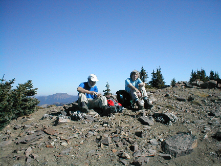
Of course on a great fall day, the views to Rainier are worth the hike by themselves.

This is a gentle hike in autumn with no snow and is kid appropriate with the one caveat that the area is National Forest and therefore open to hunting of a fairly large number of elk, deer and a few goats in the area. This is October and November but by November snows usually make this a winter outing anyway.
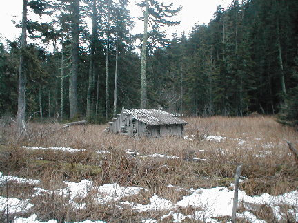
Pitcher Peak, 5933', December 25, 2004. Back again. There is virtually no snow. I was able to drive the access road to the start of off road travel and it was open to the parking area at the road's end. The summit too was almost snow free with just a foot or so on the windward slopes. For the first time I found the normally snow covered summit register. There appears to be some route finding problems. The key is to do what Beckey says but as you head up tward the notch as stated, when faced with a choice of left or right drainage forks, take the right. The objective notch really doesn't appear like one from below. it is a tight little spot where the wooded shoulder of Pitcher meets the lower, nerly horizontal, ridge. Once at the notch, anything that keeps below the rock outcroppings till a viable up route will work. It is mostly open forest. This picture is of the McGilvery cabin.
Little Si, Nancy Maring, Mike Calder, Alice Calder. February 13,2005. Just a short hike on very good trail from the new parking lot. The old Mt Si trail is also accessed from here by taking a spur. Well treed and should be cool in summer. Lots of rock to climb on bolted routes.
Old Baldy, 5795'. Mary Vesper. March 21, 2005. Familiar terrain. The current warm weather trend of 2005 has left the main road snowless to the road end trailhead. The jeep trail to Suprise Lake has some snow in shaded areas but easy going to the skid road tward the access ridge. The skid road continues to be overgrown but lack of leaves in early spring is a plus. The hill side from the skid road to the ridge top has patchy snow but is wonderful compared to chest high snow on my last visit or reports of head high brush in summer. The ridge is snowfree except the last uphill push. Summit rocks are bare. The bowl just east of the peak is completely snow free and is a pleasant shortcut to following the ridge back which is often done to avoid avalanche danger.
Bearhead 6089', East Bearhead 6052' traverse. TJ Schwertfeger, Mark Crowe. The unusually low 2005 snow pack left the road almost snowfree and passable with a passenger car (some high rocks in the road). the trail has snow in shaded areas and patches of ice tward the top from people compacted snow. Summit rocks are snow free but north slopes still have snow. TJ and Mark, intrepid souls, opted to make the traverse from Bearhead to East Bearhead rather than descend to the main trail and ascend up the clearer southern slopes of East Bearhead. We descended slightly via trail from the summit of Bearhead then worked down and eas through cliffs to the large basin between the Main and East summits. We worked up to the ridge one high point west of East Bearhead but there is significant erosion of the ridge between the two and I chose not to take the potentially exposed route along the ridge. The slopes on the north of the objective showed signs of avalanche so we opted to again climb down through the cliffy area and ascend the open southern slopes to the summit. East, west and south sides are snow free. (From the summit we saw that a set of elk tracks we had seen where we chose not to take the snow route, had traversed the far outside edges of the north bowl and crossing the ridge just east of the summit.) The ttraverse is not difficult but does take longer than just heading down the trail.
Mt Shuksan 9131'. April 2-3 2005. Char Okazaki. Sulphide Glacier. After last September's "character builder" in constant rain, we're hoping for good weather and a summit. We will again take the Shannon Ridge trail and Sulphide Glacier route. It is not technically any problem but we'll trade that for a better probability of a summit. Again, the low snow year means crevasses could already be melting out or never have really filled in to any depth.
Thanks for visiting my page. A few of the more current pictures are posted in slightly higher resolution at http://picasaweb.google.com/remlec2. Please visit again and feel free to drop me a message.
