|
Trail of Tears
State Park
3,415 acres
4 Trails: 10 miles (2 loops), Two 2 miles, .5
I-55 and MO 177
Cape Giradeau
Contact:
429 Moccasin Springs, Jackson, 63755
573-334-1711
|
Trail of Tears State Park
55 and MO 177. Contact: 429 Moccasin Springs, Jackson, 63755. 573-334-1711.
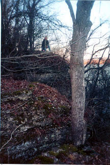
 This park is 3,415 acres and includes a portion of the Trail of Tears Historic Trail that was used by the Cherokee Indians, forced to march from Tennessee to Oklahoma.
The park offers peaceful and serene settings. It is characterized by a narrow band of loess-covered hills that support a distinct type of forest. Trees of oak and hickory, eastern forest species, such as, beech, tulip, poplar and cucumber magnolia characterize the park and Vancill Hollow Natural Area as an Appalachian mountain style forest. Majestic hardwood forests, ravines, side hollows and many pristine natural features are seen in the natural areas of Vancill Hollow and Indian Creek Wild Area. Elk and deer once roamed these forests where the open qualities are declining, therefore burns are prescribed to restore the park. Trail of Tears is a natural area of beauty and diversity.
This park is 3,415 acres and includes a portion of the Trail of Tears Historic Trail that was used by the Cherokee Indians, forced to march from Tennessee to Oklahoma.
The park offers peaceful and serene settings. It is characterized by a narrow band of loess-covered hills that support a distinct type of forest. Trees of oak and hickory, eastern forest species, such as, beech, tulip, poplar and cucumber magnolia characterize the park and Vancill Hollow Natural Area as an Appalachian mountain style forest. Majestic hardwood forests, ravines, side hollows and many pristine natural features are seen in the natural areas of Vancill Hollow and Indian Creek Wild Area. Elk and deer once roamed these forests where the open qualities are declining, therefore burns are prescribed to restore the park. Trail of Tears is a natural area of beauty and diversity.
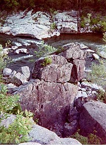
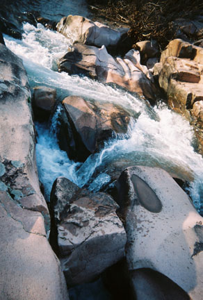
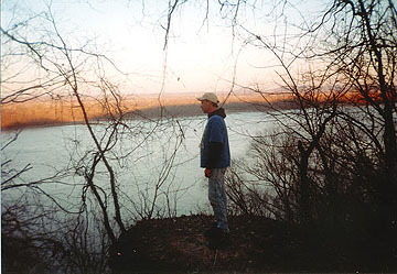
There are several picnic sites, campsites in wooded areas near the Mississippi River, fishing in the River or Lake Boutin. Bushyhead Memorial is located within the parks boundaries and is tribute to the Cherokee who died on the trail. TOT has many trails for hiking, backpacking and primitive camping. This rugged and scenic park offers numerous trails overlooking the Mississippi River. The bluffs and cliffs along the river are noted for the bald eagle roosting sites.
4 Trails:
 Peewah Trail (10 miles) access to the Indian Creek Wild Area and along the Mississippi River. This trail offers a sense of solitude, in Indian Creek Wild Area there are junglelike forests in the lowlands, floodplain forests, and wild flowers, in bloom, along the ridges and deep within the hollows. Nearby limestone bluffs tower above the river. It is moderately difficult to hike and is for both day use and overnight camping. The trail is divided into 4 segments where shorter hikes are created by various loops and segments. There is a 1.5 mile roundtrip, 3.4 mile loop and a 6 mile trail or 4.5 mile loop via the connector marker.
Sheppard Point (2 miles) ascends to a beautiful bluff top that overlooks the Mississippi River. This is a rugged trail and difficult terrain.
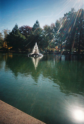
Lake Trail (2 miles) winds around Lake Boutin.
Nature Trail (.5 miles) where hikers may see white tailed deer, rabbits and squirrels.
Peewah Trail (10 miles) access to the Indian Creek Wild Area and along the Mississippi River. This trail offers a sense of solitude, in Indian Creek Wild Area there are junglelike forests in the lowlands, floodplain forests, and wild flowers, in bloom, along the ridges and deep within the hollows. Nearby limestone bluffs tower above the river. It is moderately difficult to hike and is for both day use and overnight camping. The trail is divided into 4 segments where shorter hikes are created by various loops and segments. There is a 1.5 mile roundtrip, 3.4 mile loop and a 6 mile trail or 4.5 mile loop via the connector marker.
Sheppard Point (2 miles) ascends to a beautiful bluff top that overlooks the Mississippi River. This is a rugged trail and difficult terrain.
Lake Trail (2 miles) winds around Lake Boutin.
Nature Trail (.5 miles) where hikers may see white tailed deer, rabbits and squirrels.
Return to Top
Maintz Wildlife Preserve
adjacent to Duck Creek
This park reminiscent of the deep south. The largest hardwood area of swamp remaining in MO. Here the otter play among cypress and tupleo white yellow-crowned night herons walk the shorelines. Duck Creek is home to snow geese and eagles. You can hike, bird-watch, canoe or fish.
Apple Creek Conservation Area
HWY 61, 6 miles east on State Route CC.
This park is 2,082 acres and includes a 5 mile trail. This trail is formed on the northern border for 2.5 miles by the Apple Creek stream, it also contains steep hills and valleys. Primitive camping is available in the area.
Return to Top
Cape Woods Conservation Area
HWY 55
This park is 38 acres and includes the Cape LaCroix Recreational Trail, a 4.2 mile trail of moderate skill level. This trail provides hiking and biking while near the attractions of Cape Giradeau. Skaters and skateboarders are also welcome!
Return to Top
Return to Top
|