
Survey data taken from a book by Dr. John Anderson,
called The Piercing of the Yokut Shield
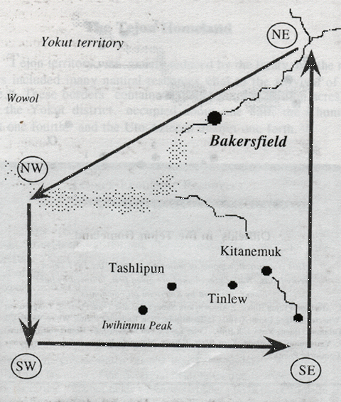
Size of Reservation "The 1851 Tejon treaty protected approximately 1.2 million acres, in the valley and foothills surrounding the contemporary town of Bakersfield [California]" (page 23)
Major River "The major drainage in the homeland was the Tubatulabal (Kern) river, which flooded large areas of the reservation including the Tulamne (Buena Vista) and Hometwoli (Kern) lakes. " (page 23).
Tulamni & Hometwoli Lakes These lakes were located south of Bakersfield, California. The Hometwoli lake is now dry, due to agricultural use of the Kern River waters. The Tulamni lake is now a recreational boating lake called Buena Vista.
Survey Markers: "The NE corner began at Lake Isabella. the NW corner was near McKittrick. The SW corner near Cuyama, and the SE corner at the top of the Kootsetahovie (Tejon) pass" (page 23).
Sacred Peak Iwihinmu (Pine) mountain, sacred center of the Chumash cosmos, was a prominent boundary marker on the southern border" (page 23).
Borbour The American diplomat, authorized to sign a sereis of 1851 treaties with native governments of California. Borbour's guidelines from Washington included instructions ot negotiate cession of potentially gold-bearing mountain lands, for territorial guarantees (by the federal government) of smaller native homelands occupying most of the lowlands in the San Joaquin (Central) valley" (from the glossary, page 41).
About this Map: "This is a concept map drawn to illustrate the author's interpretation of the 1851 Tejon treaty language. It is not an official map endorsed by either the federal or state government.
In subsequent years, the federal government surveyed a 50,000 acre 'reduced' Tejon Indian Reservation which was called Sebastian by the federals. This reservation's western border lay near the foot of the Grapevine grade of highway 5, with the bulk of the Indian lands stretching east along the foothills of what is now the Tejon Ranch.
Then the Tejon Indian lands were arbitrarily reduced again to 25,000 acres. The heart of this reduced homeland was Kootsetahovie (Tejon) canyon, where the Tejon Indians maintained their adobe homes surrounded by gardens and grazing lands for their stock.
And thereafter for generations, this dwindling fragment of the original Tejon lands was continuously reduced, until all of the Indian land title was absorbed by the legal title of the Tejon Ranch and the Tejon Indians were scattered [John Anderson, June 1, 2001].
for a free download through the John M. Anderson Library Project.
Back to Homepage
Fort Tejon
Seven Villages
