

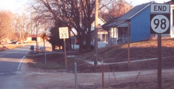
NORTH End: Stop sign, IA 16 and V64, Van Buren County

Facing north on 98

Facing north on 98

Facing west on 16
V64 is not signed in any direction, nor are there any signs for 16 and 98 on V64.

Facing west on 16
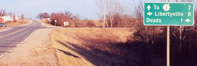
Facing east on 16
Photo by Jason Hancock

Facing east on 16

Facing west
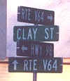
SOUTH End: Clay St., Leando, Van Buren County
Facing south on 98
Photo by Jason Hancock
From what I could tell, IA 98 is the only paved road in Leando and possibly also Douds. The latter disincorporated sometime in the 1960s while the former has been a non-town for longer than that.
Facing southeast
Photo by Jason Hancock
Why did IA 98 live?
On July 1, 2003, every state spur died - except for one. Emerging unscathed from the purge was IA 98, a less-than-2-mile road that serves two unincoporated towns. Correspondence from the DOT informed me that 98, IA 316 south of Runnells, and IA 930 in Boone County were classified as "access routes." Access to or from what, I'm not entirely sure, but for two of those, they end shortly after crossing the Des Moines River. Because 316 is the only DOT-controlled bridge between US 65 and IA 14, and 98 the only one between US 63 and IA 1, they may have been kept on the books because of their bridges. There may be precedent: IA 411, a short-lived highway, went north from US 6 in Marengo just across the Iowa River, perhaps existing only for construction of a bridge.
Pictures by Jason Hancock: Fifth, eighth, and ninth, 3/16/02
Pictures by me: First-fourth, sixth, and seventh, 5/10/05, on my first stop in Van Buren County
Page created 5/12/02; last updated 5/18/05
