

WEST End: T intersection, IA 149, Keokuk County

Facing west on 78
Why doesn't 78 continue? Because 149 was here first, that's why. It wasn't until the late 1940s that 78 made it this far west, but 149 had been here since 1926. The layout here is also that of US 63 and IA 96, where the road on the "vertical bar" of the T intersection continues on the "crossbar", only this time the vertical bar heads north.

Facing west on 78


Facing east, but heading north, on 149

Facing south on 149

Facing south on 149
EAST End: Stop sign, US 61 and H22, Louisa County

Facing east on 78

Facing east on 78

Facing east on 78
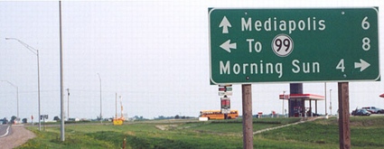
Look very closely (or look below) for the peeled-off pair of nines on this LGS. When IA 99 was decommissioned, two of the directions' LGSs peeled away the numbers; southbound 61 had the entire line peeled off. This is different from changed LGSs on IA 330 or US 30 in Marshall County; for those, lines were covered up with a strip of wood.
Facing south on 61
Photo by Jason Hancock
This is the LGS that had its entire "To 99" line peeled off. Oakville would be an acceptable substitution for an eastward destination. This intersection is (was) the location of the village of Newport, which only lives today by a small notation on the county map and the "Newport Junction Ampride" there in the background. The store sells Sterzing's potato chips, generally available within a 70-mile radius of Burlington, although they may show up elsewhere if you're lucky.

Facing south on 61
Photo by Jason Hancock
The Des Moines County line is a mile south of here.

Facing north on 61

Facing north on 61
Pictures by Jason Hancock: Tenth and eleventh, 6/22/02
Pictures by me: Top six, 5/10/05; seventh and eighth, 6/16/06; ninth, twelfth, and thirteenth, 10/29/04, during my first trip to Louisa and Des Moines counties
Page created 3/22/02; last updated 9/16/06
