

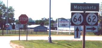
WEST End: Two-way stop*/T intersection, IA 64/Platt St., Maquoketa, Jackson County
*SB 62 and WB 64 stop; EB 64 doesn't

Facing south, but heading west, on 62

Facing south, but heading west, on 62

Facing east on 64


Facing east on 64

Facing east on 64
The signs in this assembly are reverse what they usually are. In addition, eastbound traffic does not have to stop.


The vertical nature of the left sign may make you think that both 62 and the Scenic Byway are ahead and right, but only the byway is.
Facing west on 64 (2002)
Photo by Jason Hancock

Facing west on 64 (2007)
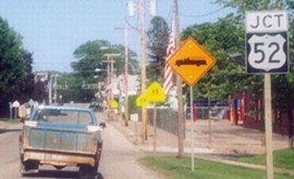
After 80 years of 61 being a mile west of 62's end, it seems odd to add a sign directing to it now. On the other hand, this gives us an assembly with a 61-62-64 sequence. (No connections with 63 and 65, though.)
*Original Number, Original End*
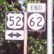
EAST End: Stop sign/T intersection, US 52/1st St., Bellevue, Jackson County
Facing east on 62
Photos by Jason Hancock
The left picture is three blocks before the right, which is at the very end. In this area, 52 is right alongside the Mississippi River.

Wider view of end signage

Facing northeast
From the end of 62, you can enter a city parking lot right by the river. South of Dam No. 12, shown in the background, the river narrows considerably.

Facing north on 52
From start to finish as the crow flies, 62 covers about 11.5 miles east-west and 13 miles north-south, but is signed east-west.

Both of the other assemblies are on the far left of this picture.
*Original Number, Original End*
Pictures by Jason Hancock: Ninth, eleventh, and twelfth, 5/26/02
Pictures by me: First-eighth and tenth, 8/31/07; 13th-16th, 4/18/06
Page created 7/21/02; last updated 11/26/07
