

(1957-July 1, 2003)
WEST End: Stoplight, US 34 and X40, West Burlington, Des Moines County
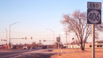
Facing north, but heading west, on 406
Photo by Jason Hancock

Facing east on 34
Photo by Jason Hancock

Facing east on 34, post-decommissioning, pre-new 34
This is on what most likely is the earliest rural four-lane divided highway in Iowa, in use as part of 34 for 60 years. (And in places, the asphalt looks it.)

Facing south on unmarked X40
EAST End: Stoplight, Gear Avenue, West Burlington, Des Moines County
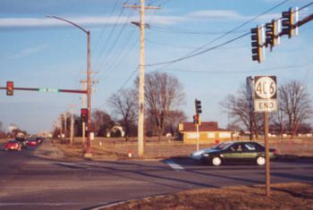
Facing east on 406
Photo by Jason Hancock
This is the farthest east "bottom 'End'" in Iowa (being near the Mississippi River will do that).

Above "End" sign from a slightly different angle
Photo by Jason Hancock
"Agency Road" is the street name for 406's route. A map titled "Federal Roads in Iowa Territory" in the book Transportation in Iowa shows two roads surveyed in 1839. One went near today's US 151, IA 1, US 218 and then at an angle from Mount Pleasant to Keosauqua, "Military Road". The other went from Burlington through Danville and over to Agency City, "Agency Road". This street keeps that historic road name alive, although today the route to Agency is US 34.
The two roads intersected in a place marked "Washington". Washington was about equidistant from Mt. Pleasant and Keosaqua and directly west of Burlington. I have been told that Washington is an old name for Hillsboro, which one site says was platted in 1840.
Last seen: 2003 (Burlington inset)

Pictures by Jason Hancock: First, second, fifth, and sixth, February 2002
Pictures by me: Third and fourth, 8/14/05
Page created 5/13/02; last updated 6/18/07
