

(1935-July 1, 2003)
NORTH End: Lanesboro, Carroll County

Facing northeast, but heading north, on 286
Contrary to previous belief, 286 does not make it to N47 on the east side of Lanesboro. Rather, it curves northeast in town, probably following a street that once paralleled the railroad, and then ends abruptly by the elevator (right) and fire station (left), a few hundred yards short of the intersection with N47. As an added note, N47 goes both ways from the intersection, and changes to E19 when the paved road turns east. According to the final road transfer list, 286 clocks in at the tiniest shade under 10 miles, 9.93 to be exact - approximately 1 1/4 football fields short.

Facing southwest, but heading south, on 286
Just past its beginning, 286 goes a little more westerly, but will curve more before leaving (see below).

Coming into downtown, 286 angles slightly more and then will turn northeast again. Notice the water tower on the right, much more visible at the north end. The leaving-town LGS, unlike most spurs, lists a town, Glidden, instead of a highway.
Junction N41


Facing north on 286
Two miles west of Lanesboro, 286 heads east from the rest of its route. Only westbound (southbound) 286 has a stop sign at this standard T intersection. The east-west part of 286 is now E16 as N41 continues north.
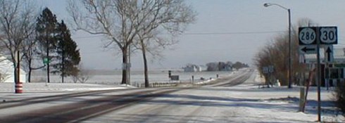
SOUTH End: Stop sign, US 30 and N44, Glidden, Carroll County

Facing south on 286
Facing south on 286
Photos by Nathan Bush


Facing west on 30
Facing east on 30
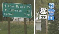
LGS on 30, a few feet behind the above picture
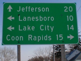
A rare sight in Iowa: Four destinations on one LGS. Coon Rapids is reached via N44, which creates the very rare situation of two different county roads coming to the same intersection.
Last seen: 2003

All pictures by me: Top four (plus enlargement), 5/7/03; fifth, eighth, and ninth, 6/29/03; tenth and eleventh, 12/23/01
Page created 3/4/02; last updated 12/18/03
