

(1931-July 1, 2003)
WEST End: Stop sign/T intersection, US 63, Howard County
All of Dennis Swanson's pictures are pre-decommissioning; mine are post-decommissioning.

Facing west on 157 (use your imagination)

Facing west on 157
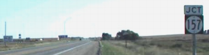
Facing south on 63
Photo by Dennis Swanson

Same post on 63 today
It's A21 because A23, unmarked on the state map, does come into Lime Springs from the southwest.

Facing south on 63
Photo by Dennis Swanson

Facing north on 63
Facing north on 63
Photo by Dennis Swanson

63 shield in above picture, facing north
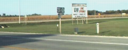
Facing east at beginning of 157
Photo by Dennis Swanson

Facing east
Lime Springs - home of Lidtke Mill and alleged destination of travelers on 63 around the New Hampton bypass.

Uh...no. In fact, US 157 doesn't even exist.

Yikes! The first time I ever saw $2 non-premium gas in Iowa. The gas station had vending machines for both the Waterloo Courier and Des Moines Register, but four miles up the road at the state line in Chester, the Phillips 66 carried the Rochester Post-Bulletin. This intersection is 1 1/2 times as far from Waterloo as it is Rochester.
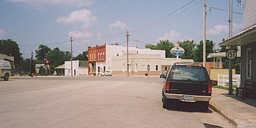
EAST End: Main St., Lime Springs, Howard County
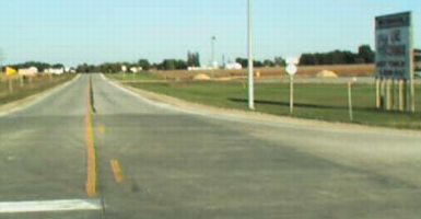
Facing northeast, but heading east, on 157
Photo by Monte Castleman
In Lime Springs, 157 turns southeast to match all the other streets in town, set to parallel the old railroad alignment. Right at the end, though, according to Monte Castleman, "it then turns left to end at the central business district at a five-way intersection." The turn was evident after decommissioning by the way the two directions that weren't 157 had stop signs. A pole to the left, out of the picture, has mile marker 1. Although IA 327's north end was closer to the Minnesota border, on the whole 157 was the northernmost spur in the state.

Facing northeast
To be accurate, it's not quite a five-way intersection, but two roads come together on the east side close enough for it to be considered one. (Note the stop signs.) At left is the first sign for A23 since entering town; it ran into 157 about three blocks behind the camera.
Last seen: 2003

While studying maps of the area, an interesting question arises: What's up with 157 being created in 1931? The year is later than logic would dictate, because this is what the dates look like:
| Number | Year created |
| 154 | 1926 (last of year) |
| 155 | 1927 |
| 156 | 1928 |
| 157 | 1931 |
| 158 | 1930 (first of year) |
The 1930 signing spree goes from 158 to 207 - 50 routes! - but 157 does NOT show up on a 1931 map I have. It does mark 1930 routes 158 and 159, but stops there. The realignment of IA 59, now US 63, between IA 9 and the Minnesota line merited the creation of a spur into Lime Springs, but the number incongruity remains. To be fair, maps in those days weren't always up to date, so it's entirely possible the realignment did happen on time to fit in with the scheme of things. Perhaps a more interesting sidelight is that one route was created in 1927, one in 1928, and none in 1929, and then the numbers just exploded.
Pictures by Dennis Swanson: Third, fifth, seventh, and ninth, 9/27/02
Thirteenth picture by Monte Castleman: Spring 2002
Pictures by me: First, second, fourth, sixth, eighth, tenth-twelfth, and fourteenth, 5/19/04
Page created 9/1/02; last updated 6/1/04
