

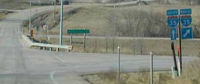
WEST End: I-35 exit 36 and R35, Clarke County
Facing west on 152
Photo by Neil Bratney
Highway 152 just barely edges out to be an east-west highway; the north-south distance between its ends is about .7 miles and the east-west distance is .9 miles as the crow flies. Its total length is about 1.3 miles. Its sole purpose is to connect I-35 and US 69 where they are the smallest distance apart.

Facing west on 152

Facing west on 152
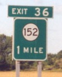
This is one of only four 152 shields on the entire route. The others are the east "End" sign and one in either direction at the route's beginnings.

Facing south on 35
Left photo by Jason Hancock
This sign, simple as it is, would be more accurate if it read "East 152; North R35". At least that would make the sign wider than the exit tabs. :-)


Facing north on 35
SOUTH End: Stop sign, US 69, city limits of Osceola, Clarke County

Facing east on 152
The speed limit on the entire route is 45 MPH, with no shoulders. There is also a greater number of houses along it than would be in most rural areas, in part due to its proximity to Osceola.

Facing north on 69


Facing north on 69


Facing south on 69
Of course Osceola isn't in Osceola County. That would be too obvious.
Top picture by Neil Bratney: 1/20/02
Fourth picture by Jason Hancock: 7/13/03
Pictures by me: Second, third, and fifth-thirteenth, 4/25/05
Page created 1/13/02; last updated 4/26/05
