

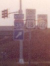
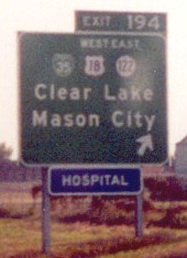
WEST End: I-35/IA 27 exit 194, Clear Lake, Cerro Gordo County

Facing west on 122/Business 18


Facing west on 122/Business 18, before and after the northbound 35 onramp
In 2003, the 27 shields were under I-35 (bottom center, top photo). Like signs around Waterloo, this has been changed so 27 gets its own sets. It's a bit misleading to have the 18 arrows as they are on the left assembly because the "left" is the same turn as southbound 35 and 27, which are marked with ahead arrows here. The better solution would be to have a simple ahead arrow under 18, and then after the northbound onramp (right photo), split it into "East 18 <-; West 18 ^".

Facing west on 122/Business 18
Right photo by Jason Hancock
The photo at right shows this assembly before IA 27, with everything on one pole.

Facing east on 18
This direction is also the north end of Business Loop I-35 though there is no signage for it.

Facing east on 18, which becomes 122
Signs on bridge before IA 27
Photo by Jason Hancock
The business route does not get signed on this older BGS, which uses a rare (for green signs) non-cutout shield for IA 122.


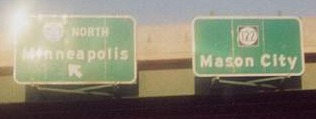
Facing north on 35
BGSs in both directions use mini-shields instead of full-sized ones, because the addition of IA 122 precluded full-size shields with directions on the sign that previously only held a US 18 shield at the top. Notice how the direction tags are on plates and "bolted" onto the signs, and Business 18 is missing.
Facing south on 35
Photo by Jason Hancock
The business route is only signed in one direction, as most in Iowa are. The resulting clutter prevents Business 18 from being included on the SB signs, although it could have been included on the NB sign. Otherwise, one interstate business route, one US business route, one US highway and one state highway would all be on the BGS!

Facing east on 122/Business 18
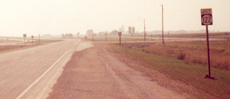
EAST End: City limits of Mason City, Cerro Gordo County

Facing east on 122
Photo by Chris Geelhart
Highway 122 has a unique sort of "hanging end". For most other routes that have/had hanging ends - that is, not ending at another signed route or intersection - they ended at the entrance to the city. Instead, 122 goes through the city and then ends at the limits. This end is 4.5 miles from US 65, and about 2.5 miles from any significant development.

Facing west on 122
Photo by Chris Geelhart
The commission meeting to turn over the relevant parts of 107 and 122 to Cerro Gordo county was Feb. 18, after the county had accepted the routes on Dec. 30, 2002.
[Old] EAST End (2001-03): City limits of Nora Springs, Floyd County


Facing east on 122
Photos by Jason Hancock
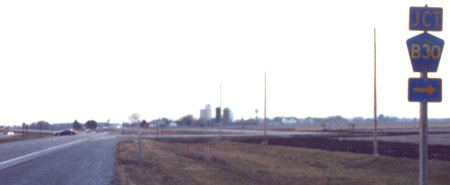
The LGS, obviously, dates back to US 18. Now it's on County Road B30, which is a road that people won't be using to get to Madison.

Facing west on 122
Photo by Jason Hancock
Because the west city limits of Nora Springs run right up to the Cerro Gordo line, and the route was only turned over in rural Floyd County, it was logical to just put the east end on the far side. The segment through Nora Springs was turned over on July 1, 2003.
[Old] EAST End (1999-2001): Stop sign, US 18(/IA 27), Floyd County

Facing east on 122, now B30
Photo by Jason Hancock
While the 122 designation was given Dec. 6, 1999, the connection to the expressway did not open until summer 2000. (The area had to be reconfigured as 18 deviated from its pre-expressway alignment.) Just off the left side of the picture is the hard right to the road behind the signs.
Highway 122 intersected IA 27 here for less than three months. Jason Hancock reports that in September 2001, as 27 was being signed, 122 was still up, but by the end of the year this portion had become B30.
Facing west on 18/27
Photo by Jason Hancock
Compare to the photo below. This was the fourth example on this site where signs have been (re)moved since the pictures were taken. The other pre-2003 examples were 218/380 near old 412 east, the LGS on old 218 near 58's old end at Dan Deery in Cedar Falls, and the change in position of the "End" sign for 279 south.
Facing west on 18
Photo by Jason Hancock
Iowa 122 used to continue US 18's old route through Nora Springs and Rudd, merging back with 18 near Rudd. This photograph became the first on this site of an end that is not the same now.

Facing east on 18
These big street signs appeared before intersections on the expressway part of 18 to increase visibility.
�Pictures by Jason Hancock: Fifth, eighth, eleventh, and 20th, 9/2/00; 15th-19th, 11/17/02<
Pictures by Chris Geelhart: 13th and 14th, 7/2/03
Pictures by me: First and 12th, 3/22/03; sixth and seventh, 7/16/05; second-fourth, ninth and tenth, 5/28/06; 21st, 7/31/05�
Page last updated 7/11/06
